
Maumee River
Encyclopedia
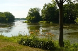
The Maumee River is a river
in northwestern Ohio
and northeastern Indiana
in the United States
. It is formed at Fort Wayne, Indiana
by the confluence of the St. Joseph
and St. Marys
rivers, and meanders northeastwardly for 137 miles (220.5 km) through an agricultural
region of glacial moraines before flowing into the Maumee Bay
of Lake Erie
at the city of Toledo, Ohio
. It was designated an Ohio State Scenic River on July 18, 1974.
. As early as 1671, French colonists called the river was called Miami du Lac, or Miami of the Lake (in contrast to the "Miami of the Ohio" or the Great Miami River
). Maumee is an anglicized spelling of the Ottawa
name for the Miami Indians
, Maamii.
The Battle of Fallen Timbers
, the final battle of the Northwest Indian War
, was fought 3/4 mile (1.2 km) north of the banks of the Maumee River. After this decisive victory for General Anthony Wayne
, Native Americans ceded a twelve mile square
tract around Perrysburg
and Maumee
to the United States
by the Treaty of Greenville
in 1795. Lands north of the river and downstream of Defiance
were ceded in 1807
, and the rest of the Maumee River valley was ceded in 1817
.
Prior to the development of canal
s, portage
s between the rivers were important trade routes. US forces built forts such as Fort Loramie, Fort Recovery
, and Fort Defiance
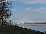
. In honor of General Wayne's victory on the banks of the Maumee, the primary bridge crossing the river near downtown Toledo is named the Anthony Wayne Suspension Bridge.
A dispute over control of part of the Maumee River region led to the so-called Toledo War
between Ohio
and the Michigan Territory
.
. In the nineteenth century, settlers struggled to drain it to convert the fertile land to farmland, altering an important habitat for migrating birds and a variety of wildlife. The wetlands was the remains of Glacial Lake Maumee
, the proglacial
ancestor of Lake Erie.
, grain
, and coal
. However, about 12 miles (19.3 km) upstream, in the town of Perrysburg, Ohio
, the river becomes much shallower and supports only recreational navigation above that point. The abandoned Miami and Erie Canal
paralleled the Maumee between Defiance, Ohio
and Toledo; portions of its towpath
are currently maintained for recreational use. The Wabash and Erie Canal
continued on from Defiance to Fort Wayne, crossing the "summit" to the Wabash River
valley. Both were important pre-railway transportation methods in the 1840-60 period. The Miami and Erie was north of the river, until it crossed an aqueduct
and turned south at Defiance, headed for Cincinnati. The Wabash canal was south of the Maumee until it reached Fort Wayne.
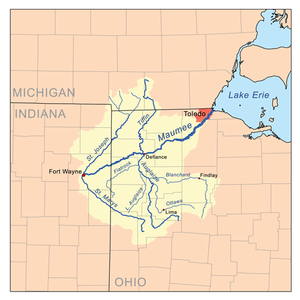
of any Great Lakes
riverwith 8316 square miles (21,538.3 km²). Its watershed includes a portion of southern Michigan
. In addition to its source tributaries
the St. Joseph and St. Marys rivers, the Maumee's principal tributaries are the Auglaize River
and the Tiffin River
, which join it at Defiance from the south and north, respectively.
run up the Maumee River is one of the largest migrations of riverbound walleyes east of the Mississippi. The migration
of the walleye normally starts in early March and runs through the end of April. Although the first week of April is "historically" the peak of the migration, it varies according to environmental conditions. When river flows rise due to snow melt-off and the river water temperature reaches 40 - 50 degrees Fahrenheit
, the migration begins. Walleye come to spawn from the western end of Lake Erie
, and the Detroit River
and Lake St. Clair
in Michigan. The most popular method of fishing for the migrating walleye is by wading out into the river and casting.

River
A river is a natural watercourse, usually freshwater, flowing towards an ocean, a lake, a sea, or another river. In a few cases, a river simply flows into the ground or dries up completely before reaching another body of water. Small rivers may also be called by several other names, including...
in northwestern Ohio
Ohio
Ohio is a Midwestern state in the United States. The 34th largest state by area in the U.S.,it is the 7th‑most populous with over 11.5 million residents, containing several major American cities and seven metropolitan areas with populations of 500,000 or more.The state's capital is Columbus...
and northeastern Indiana
Indiana
Indiana is a US state, admitted to the United States as the 19th on December 11, 1816. It is located in the Midwestern United States and Great Lakes Region. With 6,483,802 residents, the state is ranked 15th in population and 16th in population density. Indiana is ranked 38th in land area and is...
in the United States
United States
The United States of America is a federal constitutional republic comprising fifty states and a federal district...
. It is formed at Fort Wayne, Indiana
Fort Wayne, Indiana
Fort Wayne is a city in the US state of Indiana and the county seat of Allen County. The population was 253,691 at the 2010 Census making it the 74th largest city in the United States and the second largest in Indiana...
by the confluence of the St. Joseph
St. Joseph River (Maumee River)
The St. Joseph River is an tributary of the Maumee River in northwestern Ohio, and northeastern Indiana in the United States, with headwater tributaries rising in southern Michigan. It drains a primarily rural farming region in the watershed of Lake Erie. It shares its name with the St...
and St. Marys
St. Marys River (Indiana)
The St. Marys River is a tributary of the Maumee River in western Ohio and eastern Indiana in the United States. Prior to development, it was part of the Great Black Swamp. Today, it drains a primarily rural farming region in the watershed of Lake Erie....
rivers, and meanders northeastwardly for 137 miles (220.5 km) through an agricultural
Agriculture
Agriculture is the cultivation of animals, plants, fungi and other life forms for food, fiber, and other products used to sustain life. Agriculture was the key implement in the rise of sedentary human civilization, whereby farming of domesticated species created food surpluses that nurtured the...
region of glacial moraines before flowing into the Maumee Bay
Maumee Bay
Maumee Bay on Lake Erie is located in the U.S. state of Ohio, just east of the city of Toledo. The bay and the surrounding wetlands form most of the Maumee River basin, and in 1975 part of the area was incorporated into Maumee Bay State Park. The park is not huge, covering , but its wetlands...
of Lake Erie
Lake Erie
Lake Erie is the fourth largest lake of the five Great Lakes in North America, and the tenth largest globally. It is the southernmost, shallowest, and smallest by volume of the Great Lakes and therefore also has the shortest average water residence time. It is bounded on the north by the...
at the city of Toledo, Ohio
Toledo, Ohio
Toledo is the fourth most populous city in the U.S. state of Ohio and is the county seat of Lucas County. Toledo is in northwest Ohio, on the western end of Lake Erie, and borders the State of Michigan...
. It was designated an Ohio State Scenic River on July 18, 1974.
History
Historically the river was also known as the "Miami" in United States treaties with Native AmericansNative Americans in the United States
Native Americans in the United States are the indigenous peoples in North America within the boundaries of the present-day continental United States, parts of Alaska, and the island state of Hawaii. They are composed of numerous, distinct tribes, states, and ethnic groups, many of which survive as...
. As early as 1671, French colonists called the river was called Miami du Lac, or Miami of the Lake (in contrast to the "Miami of the Ohio" or the Great Miami River
Great Miami River
The Great Miami River is a tributary of the Ohio River, approximately long, in southwestern Ohio in the United States...
). Maumee is an anglicized spelling of the Ottawa
Ottawa (tribe)
The Odawa or Ottawa, said to mean "traders," are a Native American and First Nations people. They are one of the Anishinaabeg, related to but distinct from the Ojibwe nation. Their original homelands are located on Manitoulin Island, near the northern shores of Lake Huron, on the Bruce Peninsula in...
name for the Miami Indians
Miami tribe
The Miami are a Native American nation originally found in what is now Indiana, southwest Michigan, and western Ohio. The Miami Tribe of Oklahoma is the only federally recognized tribe of Miami Indians in the United States...
, Maamii.
The Battle of Fallen Timbers
Battle of Fallen Timbers
The Battle of Fallen Timbers was the final battle of the Northwest Indian War, a struggle between American Indian tribes affiliated with the Western Confederacy and the United States for control of the Northwest Territory...
, the final battle of the Northwest Indian War
Northwest Indian War
The Northwest Indian War , also known as Little Turtle's War and by various other names, was a war fought between the United States and a confederation of numerous American Indian tribes for control of the Northwest Territory...
, was fought 3/4 mile (1.2 km) north of the banks of the Maumee River. After this decisive victory for General Anthony Wayne
Anthony Wayne
Anthony Wayne was a United States Army general and statesman. Wayne adopted a military career at the outset of the American Revolutionary War, where his military exploits and fiery personality quickly earned him a promotion to the rank of brigadier general and the sobriquet of Mad Anthony.-Early...
, Native Americans ceded a twelve mile square
Twelve Mile Square Reservation
The Twelve Mile Square Reservation, also called the Twelve Mile Square Reserve, was a tract of land in Ohio ceded by Indians to the United States of America in the Treaty of Greenville in 1795...
tract around Perrysburg
Perrysburg, Ohio
As of the census of 2000, there were 16,945 people, 6,592 households, and 4,561 families residing in the city. The population density was 1,899.2 people per square mile . There were 6,964 housing units at an average density of 780.5 per square mile...
and Maumee
Maumee, Ohio
Maumee is a city in Lucas County, Ohio, United States. It is a suburb of Toledo along the Maumee River. The population was 14,286 at the 2010 census. Maumee was also declared an All-America City by the National Civic League in June 2006.-Geography:...
to the United States
United States
The United States of America is a federal constitutional republic comprising fifty states and a federal district...
by the Treaty of Greenville
Treaty of Greenville
The Treaty of Greenville was signed at Fort Greenville , on August 3, 1795, between a coalition of Native Americans & Frontiers men, known as the Western Confederacy, and the United States following the Native American loss at the Battle of Fallen Timbers. It put an end to the Northwest Indian War...
in 1795. Lands north of the river and downstream of Defiance
Defiance, Ohio
As of the census of 2000, there were 16,465 people, 6,572 households, and 4,422 families residing in the city. The population density was 1,562.4 people per square mile . There were 7,061 housing units at an average density of 670.0 per square mile...
were ceded in 1807
Treaty of Detroit
The Treaty of Detroit was a treaty between the United States and the Ottawa, Chippewa, Wyandot and Potawatomi Native American nations. The treaty was signed at Detroit, Michigan on November 17, 1807, with William Hull, governor of the Michigan Territory and superintendent of Indian affairs the sole...
, and the rest of the Maumee River valley was ceded in 1817
Treaty of Fort Meigs
The Treaty of Fort Meigs, also called the Treaty of the Foot of the Rapids, was signed September 29, 1817 between the chiefs and warriors of the Wyandot, Seneca, Delaware, Shawnee, Potawatomi, Ottawa and Chippewa, tribes of native Americans and the United States of America, represented by Lewis...
.
Prior to the development of canal
Canal
Canals are man-made channels for water. There are two types of canal:#Waterways: navigable transportation canals used for carrying ships and boats shipping goods and conveying people, further subdivided into two kinds:...
s, portage
Portage
Portage or portaging refers to the practice of carrying watercraft or cargo over land to avoid river obstacles, or between two bodies of water. A place where this carrying occurs is also called a portage; a person doing the carrying is called a porter.The English word portage is derived from the...
s between the rivers were important trade routes. US forces built forts such as Fort Loramie, Fort Recovery
Fort Recovery
Fort Recovery was a United States Army fort begun in late 1793 and completed in March 1794 under orders by General "Mad" Anthony Wayne. It was located on the site of the present-day village of Fort Recovery, Ohio, United States, on the Wabash River within two miles of the boundary with...
, and Fort Defiance
Fort Defiance (Ohio)
Fort Defiance was ordered built by General "Mad" Anthony Wayne in August 1794 at the confluence of the Auglaize and Maumee rivers. It was the last of a line of defenses constructed by American forces in the campaign leading to the Northwest Indian War's Battle of Fallen Timbers on August 20,...
. In honor of General Wayne's victory on the banks of the Maumee, the primary bridge crossing the river near downtown Toledo is named the Anthony Wayne Suspension Bridge.
A dispute over control of part of the Maumee River region led to the so-called Toledo War
Toledo War
The Toledo War , also known as the Michigan-Ohio War, was the almost entirely bloodless boundary dispute between the U.S. state of Ohio and the adjoining territory of Michigan....
between Ohio
Ohio
Ohio is a Midwestern state in the United States. The 34th largest state by area in the U.S.,it is the 7th‑most populous with over 11.5 million residents, containing several major American cities and seven metropolitan areas with populations of 500,000 or more.The state's capital is Columbus...
and the Michigan Territory
Michigan Territory
The Territory of Michigan was an organized incorporated territory of the United States that existed from June 30, 1805, until January 26, 1837, when the final extent of the territory was admitted to the Union as the State of Michigan...
.
Natural history
The watershed of the Maumee River was a large wetlands known as the Great Black SwampGreat Black Swamp
The Great Black Swamp, or simply Black Swamp, was a glacially caused wetland in northwest Ohio, United States, extending into extreme northeastern Indiana, that existed from the end of the Wisconsin glaciation until the late 19th century...
. In the nineteenth century, settlers struggled to drain it to convert the fertile land to farmland, altering an important habitat for migrating birds and a variety of wildlife. The wetlands was the remains of Glacial Lake Maumee
Glacial Lake Maumee
Glacial Lake Maumee was a proglacial lake that was an ancestor of present-day Lake Erie. It formed about 14,000 years ago. As the Erie Lobe of the Wisconsin Glacier retreated at the end of the last ice age, it left meltwater in a previously-existing depressional area that was the valley of an...
, the proglacial
Proglacial lake
In geology, a proglacial lake is a lake formed either by the damming action of a moraine or ice dam during the retreat of a melting glacier, or by meltwater trapped against an ice sheet due to isostatic depression of the crust around the ice...
ancestor of Lake Erie.
Transportation
The mouth of the river at Lake Erie is wide and supports considerable commercial traffic, including oilPetroleum
Petroleum or crude oil is a naturally occurring, flammable liquid consisting of a complex mixture of hydrocarbons of various molecular weights and other liquid organic compounds, that are found in geologic formations beneath the Earth's surface. Petroleum is recovered mostly through oil drilling...
, grain
GRAIN
GRAIN is a small international non-profit organisation that works to support small farmers and social movements in their struggles for community-controlled and biodiversity-based food systems. Our support takes the form of independent research and analysis, networking at local, regional and...
, and coal
Coal
Coal is a combustible black or brownish-black sedimentary rock usually occurring in rock strata in layers or veins called coal beds or coal seams. The harder forms, such as anthracite coal, can be regarded as metamorphic rock because of later exposure to elevated temperature and pressure...
. However, about 12 miles (19.3 km) upstream, in the town of Perrysburg, Ohio
Perrysburg, Ohio
As of the census of 2000, there were 16,945 people, 6,592 households, and 4,561 families residing in the city. The population density was 1,899.2 people per square mile . There were 6,964 housing units at an average density of 780.5 per square mile...
, the river becomes much shallower and supports only recreational navigation above that point. The abandoned Miami and Erie Canal
Miami and Erie Canal
The Miami and Erie Canal was a canal that connected the Ohio River in Cincinnati, Ohio with Lake Erie in Toledo, Ohio. Construction on the canal began in 1825 and was completed in 1845. It consisted of 19 aqueducts, three guard locks, and 103 canal locks. Each lock measured by and they...
paralleled the Maumee between Defiance, Ohio
Defiance, Ohio
As of the census of 2000, there were 16,465 people, 6,572 households, and 4,422 families residing in the city. The population density was 1,562.4 people per square mile . There were 7,061 housing units at an average density of 670.0 per square mile...
and Toledo; portions of its towpath
Towpath
A towpath is a road or trail on the bank of a river, canal, or other inland waterway. The purpose of a towpath is to allow a land vehicle, beasts of burden, or a team of human pullers to tow a boat, often a barge...
are currently maintained for recreational use. The Wabash and Erie Canal
Wabash and Erie Canal
The Wabash and Erie Canal was a shipping canal that linked the Great Lakes to the Ohio River via an artificial waterway. The canal provided traders with access from the Great Lakes all the way to the Gulf of Mexico...
continued on from Defiance to Fort Wayne, crossing the "summit" to the Wabash River
Wabash River
The Wabash River is a river in the Midwestern United States that flows southwest from northwest Ohio near Fort Recovery across northern Indiana to southern Illinois, where it forms the Illinois-Indiana border before draining into the Ohio River, of which it is the largest northern tributary...
valley. Both were important pre-railway transportation methods in the 1840-60 period. The Miami and Erie was north of the river, until it crossed an aqueduct
Aqueduct
An aqueduct is a water supply or navigable channel constructed to convey water. In modern engineering, the term is used for any system of pipes, ditches, canals, tunnels, and other structures used for this purpose....
and turned south at Defiance, headed for Cincinnati. The Wabash canal was south of the Maumee until it reached Fort Wayne.
Watershed
The Maumee has the largest watershedDrainage basin
A drainage basin is an extent or an area of land where surface water from rain and melting snow or ice converges to a single point, usually the exit of the basin, where the waters join another waterbody, such as a river, lake, reservoir, estuary, wetland, sea, or ocean...
of any Great Lakes
Great Lakes
The Great Lakes are a collection of freshwater lakes located in northeastern North America, on the Canada – United States border. Consisting of Lakes Superior, Michigan, Huron, Erie, and Ontario, they form the largest group of freshwater lakes on Earth by total surface, coming in second by volume...
riverwith 8316 square miles (21,538.3 km²). Its watershed includes a portion of southern Michigan
Michigan
Michigan is a U.S. state located in the Great Lakes Region of the United States of America. The name Michigan is the French form of the Ojibwa word mishigamaa, meaning "large water" or "large lake"....
. In addition to its source tributaries
Tributary
A tributary or affluent is a stream or river that flows into a main stem river or a lake. A tributary does not flow directly into a sea or ocean...
the St. Joseph and St. Marys rivers, the Maumee's principal tributaries are the Auglaize River
Auglaize River
The Auglaize River is a tributary of the Maumee River in northwestern Ohio in the United States. It drains a primarily rural farming area in the watershed of Lake Erie. The name of the river either comes from a Shawnee phrase meaning "fallen timbers" or a French term for "frozen water."It rises in...
and the Tiffin River
Tiffin River
The Tiffin River is a tributary of the Maumee River in northwestern Ohio in the United States. Headwater tributaries of the river rise in southeastern Michigan. The river drains a primarily rural farming region in the watershed of Lake Erie. Early French traders called the river Crique Féve,...
, which join it at Defiance from the south and north, respectively.
Islands
There are several small islands in the section of the Maumee River in northwest Ohio. The names of the islands are:- Indian Island - near Farnsworth Park west of ToledoToledo, OhioToledo is the fourth most populous city in the U.S. state of Ohio and is the county seat of Lucas County. Toledo is in northwest Ohio, on the western end of Lake Erie, and borders the State of Michigan...
- Missionary Island - actually several islands; near Farnsworth Park west of Toledo
- Granger Island - near Waterville, OhioWaterville, OhioWaterville is a village in Lucas County, Ohio, United States, along the Maumee River. The population was 4,828 at the 2000 census.-Geography:Waterville is located at ....
- Butler Island - near Side Cut Metropark
- Bluegrass Island - part of Side Cut Metropark
- Audubon Island - the largest island in the Maumee River, formerly McKee's Island or Ewing Island, part of SideCut Park
- Marengo Island - near Maumee, OhioMaumee, OhioMaumee is a city in Lucas County, Ohio, United States. It is a suburb of Toledo along the Maumee River. The population was 14,286 at the 2010 census. Maumee was also declared an All-America City by the National Civic League in June 2006.-Geography:...
- Horseshoe Island - near Walbridge Park in Toledo
- Clark Island - near Walbridge Park in Toledo
- Corbutt Island - in Toledo
- Grassy Island - near Cullen Park in Toledo
- Preston Island - near Defiance, Ohio
Walleye run
According to the Ohio Department of Natural Resources, the annual walleyeWalleye
Walleye is a freshwater perciform fish native to most of Canada and to the northern United States. It is a North American close relative of the European pikeperch...
run up the Maumee River is one of the largest migrations of riverbound walleyes east of the Mississippi. The migration
Fish migration
Many types of fish migrate on a regular basis, on time scales ranging from daily to annually or longer, and over distances ranging from a few metres to thousands of kilometres...
of the walleye normally starts in early March and runs through the end of April. Although the first week of April is "historically" the peak of the migration, it varies according to environmental conditions. When river flows rise due to snow melt-off and the river water temperature reaches 40 - 50 degrees Fahrenheit
Fahrenheit
Fahrenheit is the temperature scale proposed in 1724 by, and named after, the German physicist Daniel Gabriel Fahrenheit . Within this scale, the freezing of water into ice is defined at 32 degrees, while the boiling point of water is defined to be 212 degrees...
, the migration begins. Walleye come to spawn from the western end of Lake Erie
Lake Erie
Lake Erie is the fourth largest lake of the five Great Lakes in North America, and the tenth largest globally. It is the southernmost, shallowest, and smallest by volume of the Great Lakes and therefore also has the shortest average water residence time. It is bounded on the north by the...
, and the Detroit River
Detroit River
The Detroit River is a strait in the Great Lakes system. The name comes from the French Rivière du Détroit, which translates literally as "River of the Strait". The Detroit River has served an important role in the history of Detroit and is one of the busiest waterways in the world. The river...
and Lake St. Clair
Lake Saint Clair (North America)
Lake St. Clair is a fresh-water lake named after Clare of Assisi that lies between the Province of Ontario and the State of Michigan, and its midline also forms the boundary between Canada and the United States of America. Lake St. Clair includes the Anchor Bay along the Metro Detroit coastline...
in Michigan. The most popular method of fishing for the migrating walleye is by wading out into the river and casting.
Cities and towns along the river
- Antwerp, OhioAntwerp, OhioAntwerp is a village in Paulding County, Ohio, United States, along the Maumee River. The population was 1,740 at the 2000 census.Antwerp is the nearest village to the Six Mile Reservoir, the site of the Reservoir War in 1887. Antwerp is the birthplace of Asa Long, the English draughts player...
- Defiance, OhioDefiance, OhioAs of the census of 2000, there were 16,465 people, 6,572 households, and 4,422 families residing in the city. The population density was 1,562.4 people per square mile . There were 7,061 housing units at an average density of 670.0 per square mile...
- Florida, OhioFlorida, OhioFlorida is a village in Henry County, Ohio, United States, along the Maumee River. The population was 246 at the 2000 census.-Geography:Florida is located at ....
- Fort Wayne, IndianaFort Wayne, IndianaFort Wayne is a city in the US state of Indiana and the county seat of Allen County. The population was 253,691 at the 2010 Census making it the 74th largest city in the United States and the second largest in Indiana...
- Grand Rapids, OhioGrand Rapids, OhioGrand Rapids is a village in Wood County, Ohio, United States, along the Maumee River. The population was 1,002 at the 2000 census. Grand Rapids is served by a branch of the Weston Public Library....
- Maumee, OhioMaumee, OhioMaumee is a city in Lucas County, Ohio, United States. It is a suburb of Toledo along the Maumee River. The population was 14,286 at the 2010 census. Maumee was also declared an All-America City by the National Civic League in June 2006.-Geography:...
- Napoleon, OhioNapoleon, OhioAs of the census of 2000, there were 9,318 people, 3,813 households, and 2,470 families residing in the city. The population density was 1,668.1 people per square mile . There were 4,066 housing units at an average density of 727.9 per square mile...
- New Haven, IndianaNew Haven, Indiana-Demographics:As of the census of 2000, there were 12,406 people, 4,900 households, and 3,415 families residing in the city. The population density was 1,522.0 people per square mile . There were 5,141 housing units at an average density of 630.7 per square mile...
- Perrysburg, OhioPerrysburg, OhioAs of the census of 2000, there were 16,945 people, 6,592 households, and 4,561 families residing in the city. The population density was 1,899.2 people per square mile . There were 6,964 housing units at an average density of 780.5 per square mile...
- Rossford, OhioRossford, OhioRossford is a city in Wood County, Ohio, United States, along the Maumee River. The population was 6,406 at the 2000 census. The town includes the intersection of Interstate 75 and the Ohio Turnpike.- History :...
- Toledo, OhioToledo, OhioToledo is the fourth most populous city in the U.S. state of Ohio and is the county seat of Lucas County. Toledo is in northwest Ohio, on the western end of Lake Erie, and borders the State of Michigan...
- Waterville, OhioWaterville, OhioWaterville is a village in Lucas County, Ohio, United States, along the Maumee River. The population was 4,828 at the 2000 census.-Geography:Waterville is located at ....
See also
- Great Black SwampGreat Black SwampThe Great Black Swamp, or simply Black Swamp, was a glacially caused wetland in northwest Ohio, United States, extending into extreme northeastern Indiana, that existed from the end of the Wisconsin glaciation until the late 19th century...
- List of Indiana rivers
- List of Ohio rivers
- USS Maumee (AO-2)USS Maumee (AO-2)The second USS Maumee was laid down as Fuel Ship No. 14 on 23 July 1914 by Navy Shipyard, Mare Island, Calif.; launched 17 April 1915; sponsored by Miss Janet Crose; and commissioned 20 October 1916, Lt. Comdr. Henry C. Dinger in command...
— a fleet oiler built in 1915.
Further reading
- Arthur Benke & Colbert Cushing, "Rivers of North America". Elsevier Academic PressAcademic PressAcademic Press is an academic book publisher. Originally independent, it was acquired by Harcourt, Brace & World in 1969. Reed Elsevier bought Harcourt in 2000, and Academic Press is now an imprint of Elsevier....
, 2005 ISBN 0-12-088253-1
External links
- Maumee River Wakeboard & Ski Site
- Maumee Valley Heritage Corridor
- EPA Maumee River site
- Maumee River Basin Commission (Indiana)