
Treaty of Detroit
Encyclopedia


Treaty
A treaty is an express agreement under international law entered into by actors in international law, namely sovereign states and international organizations. A treaty may also be known as an agreement, protocol, covenant, convention or exchange of letters, among other terms...
between the United States
United States
The United States of America is a federal constitutional republic comprising fifty states and a federal district...
and the Ottawa
Ottawa (tribe)
The Odawa or Ottawa, said to mean "traders," are a Native American and First Nations people. They are one of the Anishinaabeg, related to but distinct from the Ojibwe nation. Their original homelands are located on Manitoulin Island, near the northern shores of Lake Huron, on the Bruce Peninsula in...
, Chippewa, Wyandot and Potawatomi
Potawatomi
The Potawatomi are a Native American people of the upper Mississippi River region. They traditionally speak the Potawatomi language, a member of the Algonquian family. In the Potawatomi language, they generally call themselves Bodéwadmi, a name that means "keepers of the fire" and that was applied...
Native American
Native Americans in the United States
Native Americans in the United States are the indigenous peoples in North America within the boundaries of the present-day continental United States, parts of Alaska, and the island state of Hawaii. They are composed of numerous, distinct tribes, states, and ethnic groups, many of which survive as...
nations. The treaty was signed at Detroit, Michigan
Detroit, Michigan
Detroit is the major city among the primary cultural, financial, and transportation centers in the Metro Detroit area, a region of 5.2 million people. As the seat of Wayne County, the city of Detroit is the largest city in the U.S. state of Michigan and serves as a major port on the Detroit River...
on November 17, 1807, with William Hull
William Hull
William Hull was an American soldier and politician. He fought in the American Revolution, was Governor of Michigan Territory, and was a general in the War of 1812, for which he is best remembered for surrendering Fort Detroit to the British.- Early life and Revolutionary War :He was born in...
, governor of the Michigan Territory
Michigan Territory
The Territory of Michigan was an organized incorporated territory of the United States that existed from June 30, 1805, until January 26, 1837, when the final extent of the territory was admitted to the Union as the State of Michigan...
and superintendent of Indian affairs the sole representative of the U.S.
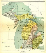
With this treaty, the First Nations ceded claim to a large portion of land in what is now Southeast Michigan
Southeast Michigan
Southeast Michigan, also called Southeastern Michigan, is a region in the Lower Peninsula of the U.S. state of Michigan that is home to a majority of the state's businesses and industries as well as slightly over half of the state's population, most of whom are concentrated in Metro...
and northwest Ohio
Ohio
Ohio is a Midwestern state in the United States. The 34th largest state by area in the U.S.,it is the 7th‑most populous with over 11.5 million residents, containing several major American cities and seven metropolitan areas with populations of 500,000 or more.The state's capital is Columbus...
. The boundary definition in the treaty began with the "mouth of the Miami river of the lakes" or what is now known as the Maumee River
Maumee River
The Maumee River is a river in northwestern Ohio and northeastern Indiana in the United States. It is formed at Fort Wayne, Indiana by the confluence of the St. Joseph and St. Marys rivers, and meanders northeastwardly for through an agricultural region of glacial moraines before flowing into the...
at Toledo, Ohio
Toledo, Ohio
Toledo is the fourth most populous city in the U.S. state of Ohio and is the county seat of Lucas County. Toledo is in northwest Ohio, on the western end of Lake Erie, and borders the State of Michigan...
. From there the boundary ran up the middle of the river to the mouth of the Auglaize River
Auglaize River
The Auglaize River is a tributary of the Maumee River in northwestern Ohio in the United States. It drains a primarily rural farming area in the watershed of Lake Erie. The name of the river either comes from a Shawnee phrase meaning "fallen timbers" or a French term for "frozen water."It rises in...
at what is now Defiance, Ohio
Defiance, Ohio
As of the census of 2000, there were 16,465 people, 6,572 households, and 4,422 families residing in the city. The population density was 1,562.4 people per square mile . There were 7,061 housing units at an average density of 670.0 per square mile...
, then due north until it intersected a parallel of latitude at the outlet of Lake Huron
Lake Huron
Lake Huron is one of the five Great Lakes of North America. Hydrologically, it comprises the larger portion of Lake Michigan-Huron. It is bounded on the east by the Canadian province of Ontario and on the west by the state of Michigan in the United States...
into the St. Clair River
St. Clair River
The St. Clair River is a river in central North America which drains Lake Huron into Lake St Clair, forming part of the international boundary between the Canadian province of Ontario and the U.S. state of Michigan...
.
This north-south line would become the Michigan Meridian
Michigan Meridian
The Michigan Meridian is the meridian used as a reference in the Michigan Survey, the survey of the U.S. state of Michigan in the early 19th century. It is located at 84 degrees, 22 minutes and 24 seconds west longitude at its northern terminus at Sault Ste...
used in surveying of Michigan lands. The intersecting parallel of latitude crossed the meridian at the northeast corner of what is now Sciota Township
Sciota Township, Michigan
Sciota Township is a civil township of Shiawassee County in the U.S. state of Michigan. The population was 1,801 at the 2000 census.-Geography:...
in Shiawassee County
Shiawassee County, Michigan
-Transportation:-Demographics:As of the census of 2000, there were 71,687 people, 26,896 households, and 19,849 families residing in the county. The population density was 133 people per square mile . There were 29,087 housing units at an average density of 54 per square mile...
in the middle of the border with Clinton County
Clinton County, Michigan
-Demographics:As of the census of 2000, there were 64,753 people, 23,653 households, and 17,976 families residing in the county. The population density was 113 people per square mile . There were 24,630 housing units at an average density of 43 per square mile...
. From this point the treaty boundary ran northeast to White Rock
White Rock, Michigan
White Rock is a tiny unincorporated community of Sherman Township at the southeast corner of Huron County in the U.S. state of Michigan. The community is at the mouth of White Rock Creek on the shore of Lake Huron...
in Lake Huron, then due east to the international boundary with what was then Upper Canada
Upper Canada
The Province of Upper Canada was a political division in British Canada established in 1791 by the British Empire to govern the central third of the lands in British North America and to accommodate Loyalist refugees from the United States of America after the American Revolution...
, and then along the international boundary through the St. Clair River, Lake St. Clair, the Detroit River and then into Lake Erie to a point due east of the mouth of the Maumee River, and finally west back to the point of beginning.