
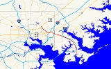
Maryland Route 151
Encyclopedia
Maryland Route 151 is a state highway
in the U.S. state of Maryland
. Known for most of its length as North Point Boulevard, the state highway runs 10.8 miles (17.4 km) from 7th Street in Sparrows Point north to U.S. Route 1
(US 1) in Baltimore. MD 151 is a four- to six-lane divided highway that connects the communities of Edgemere
and Dundalk
on the Patapsco River Neck of southeastern Baltimore County
with industrial areas in Sparrows Point and East Baltimore. MD 151 was originally constructed in the early 1920s from Sparrows Point to Edgemere. The highway was connected to Baltimore by the Baltimore County portion of MD 20
, a number also assigned to the highway from Rock Hall
to Chestertown
in Kent County
. During World War II, MD 151 was extended north through Dundalk on a new divided highway parallel to MD 20 and through East Baltimore on an expanded Erdman Avenue to connect the Bethlehem Steel
complex at Sparrows Point with MD 150
and US 40
. In the late 1960s and early 1970s, Interstate 695
(I-695) was constructed parallel to MD 151 through Dundalk.
. Sparrows Point Boulevard continues south to a gate south of F Street. MD 151 heads northeast as a four-lane divided highway. The state highway leaves the steel complex by crossing over the Patapsco & Back Rivers Railroad and Wharf Road, which is MD 151B and with which MD 151 has a modified trumpet interchange. At Sparrows Point Road, MD 151's name changes to North Point Boulevard and the highway curves north to bypass Edgemere. The state highway intersects MD 158
(Bethlehem Boulevard), which heads east toward North Point Road. North Point Road heads south through Edgemere toward North Point State Park
and Fort Howard
. Just north of MD 158, MD 151 has a partial interchange with I-695 (Baltimore Beltway), which includes a ramp from MD 151 to northbound I-695 and a loop ramp from southbound I-695 to MD 151. The movements to and from the Francis Scott Key Bridge
are made via MD 158 to the west.
MD 151 passes under a rail line owned by Norfolk Southern Railway
and intersects Wise Avenue before passing through the North Point Village
neighborhood of Dundalk, where the highway is paralleled by North Point Road on the east. At Cove Road, a connector to the parallel I-695, North Point Road switches to the west side of MD 151. The area north of North Point Village, where Patapsco River Neck narrows to a width of 1 miles (1.6 km) between the Back River
and Bear Creek, was the site of the Battle of North Point
, a September 12, 1814 engagement that was part of the encompassing Battle of Baltimore
in the War of 1812
. At Bread and Cheese Creek
, northbound MD 151 crosses to the east side of I-695, which runs in the median of the state highway. Northbound MD 151 and northbound I-695 and the southbound directions of each highway are connected to each other by ramps. Northbound MD 151 crosses over I-695 and has a U-turn ramp before the highway's partial interchange with the ramps between I-695 and the northern end of MD 157
(Merritt Boulevard). There is no access from northbound MD 151 to MD 157. The state highway continues northwest along the southern edge of the Eastpoint Mall
ahead of its cloverleaf interchange with MD 150 (Eastern Avenue), then enters an industrial area where the highway intersects the Canton Railroad
at grade.
MD 151 enters the city of Baltimore just west of its intersection with Rolling Mill Road and Kane Street. The state highway passes under I-95, a Norfolk Southern Railway railyard, and the Amtrak Northeast Corridor. At North Point Road, MD 151's name changes to Erdman Avenue and the highway veers west to pass under CSX
's Philadelphia Subdivision. The state highway veers northwest at its crossing of I-895 (Harbor Tunnel Thruway) just before the highway's cloverleaf interchange with US 40 (Pulaski Highway), which also includes a ramp from southbound MD 151 to southbound I-895. Connections between eastbound US 40 and northbound MD 151 are made via Mapleton Avenue just east of I-895. MD 151 continues northwest concurrent
with US 40 Truck as a six-lane boulevard between the Armistead Gardens
neighborhood to the east and industrial facilities on the west. The state highway passes by Archbishop Curley High School
and through the Belair-Edison
neighborhood before reaching its northern terminus at US 1 (Belair Road), onto which US 40 Truck turns west. Erdman Avenue continues northwest as a two-lane street along the eastern edge of Clifton Park
to MD 147
(Harford Road).
to recommend MD 151 and MD 20 from Sparrows Point to Baltimore be expanded from 20 to 40 ft (6.1 to 12.2 m) in width.
Modern MD 151 was constructed between 1940 and 1944 as a defense access project to better connect Baltimore with Bethlehem Steel's steel mills and shipyards at Sparrows Point. MD 151 was reconstructed and extended north as a four-lane divided highway from Sparrows Point to Wise Avenue in Dundalk between 1940 and 1942. This construction included the highway's bypass of Edgemere; the bypassed portion of Sparrows Point Road from the expanded highway east to MD 20 was designated MD 718 by 1946. In Baltimore, Erdman Avenue was expanded to a divided highway from US 1 to US 40 and extended south to North Point Road by 1942; MD 151's underpasses of the Baltimore and Ohio Railroad
(now CSX) and Pennsylvania Railroad
(now Amtrak) and its interchange with US 40 were completed at that time. MD 151 from Wise Avenue to the Baltimore City line was constructed between 1942 and 1944; this work included the cloverleaf interchange with MD 150.
With the construction of modern MD 151, MD 20 was split into several disjoint segments of North Point Road: one from near Fort Howard to MD 151 in Edgemere, another along the northbound side of MD 151 from Edgemere to North Point Village, a third on the southbound side MD 151 from North Point Village to the MD 150–MD 151 interchange, and a fourth between MD 151 and US 40 in Baltimore. The Baltimore City segment was removed from the state highway system in 1956. The portion of MD 20 from near Fort Howard to MD 718 in Edgemere was transferred to county maintenance in 1987. The remaining portions of MD 20 and MD 718 in Edgemere were removed from the state highway system around 1999.
MD 151's interchanges with Wharf Road in Sparrows Point and with MD 20 and Bethlehem Boulevard in Edgemere were built by 1963. The state highway's partial interchange with Merritt Boulevard was constructed in 1969 and the crossover interchange with I-695 was built in 1971. I-695 was completed between Merritt Boulevard and MD 151 in Edgemere in 1974. In 1999, as part of the reconstruction of I-695 from the Key Bridge to Edgemere from a two-lane viaduct to a four-lane surface freeway, MD 151's interchange with MD 20 and MD 158 in Edgemere was reduced to a standard intersection and the highway's present partial interchange with I-695 was built.
!County
!Location
!Mile
!Destinations
!Notes
|-
|rowspan=8|Baltimore
|rowspan=2|Sparrows Point
|0.00
|7th Street west / Sparrows Point Boulevard south
|Southern terminus
|-
|0.53
|Wharf Road
|Interchange; unsigned MD 151B
|-
|rowspan=2|Edgemere
|1.72
|
|
|-
|1.89
|
|I-695 Exit 42; southbound exit from and northbound entrance to I-695
|-
|rowspan=4|Dundalk
|5.43
|
|I-695 Exit 40; northbound entrance and exit
|-
|5.57
|
|I-695 Exit 40; southbound entrance and exit
|-
|6.12
|
|Interchange; no exit from northbound MD 151
|-
|6.85
|
|Interchange
|-
|rowspan=3 colspan=2|Baltimore City
|8.70
|
|I-895 Exit 13
|-
|8.85
|
|Interchange; south end of concurrency with US 40 Truck
|-
|10.80
|
|Northern terminus
State highway
State highway, state road or state route can refer to one of three related concepts, two of them related to a state or provincial government in a country that is divided into states or provinces :#A...
in the U.S. state of Maryland
Maryland
Maryland is a U.S. state located in the Mid Atlantic region of the United States, bordering Virginia, West Virginia, and the District of Columbia to its south and west; Pennsylvania to its north; and Delaware to its east...
. Known for most of its length as North Point Boulevard, the state highway runs 10.8 miles (17.4 km) from 7th Street in Sparrows Point north to U.S. Route 1
U.S. Route 1 in Maryland
U.S. Route 1 is the easternmost and longest of the major north–south routes of the United States Numbered Highway System, running from Key West, Florida to Fort Kent, Maine. In the U.S...
(US 1) in Baltimore. MD 151 is a four- to six-lane divided highway that connects the communities of Edgemere
Edgemere, Maryland
-Demographics:As of the census of 2000, there were 9,248 people, 3,530 households, and 2,513 families residing in the CDP. The population density was 855.6 people per square mile . There were 3,764 housing units at an average density of 348.2/sq mi...
and Dundalk
Dundalk, Maryland
-Demographics:As of the census of 2000, there were 62,306 people, 24,772 households, and 16,968 families residing in the CDP. The population density was 4,689.5 people per square mile . There were 26,385 housing units at an average density of 1,985.9 per square mile...
on the Patapsco River Neck of southeastern Baltimore County
Baltimore County, Maryland
Baltimore County is a county located in the northern part of the US state of Maryland. In 2010, its population was 805,029. It is part of the Baltimore-Washington Metropolitan Area. Its county seat is Towson. The name of the county was derived from the barony of the Proprietor of the Maryland...
with industrial areas in Sparrows Point and East Baltimore. MD 151 was originally constructed in the early 1920s from Sparrows Point to Edgemere. The highway was connected to Baltimore by the Baltimore County portion of MD 20
Maryland Route 20
Maryland Route 20 is a state highway in the U.S. state of Maryland. The state highway runs from Beach Road and Lawton Avenue in Rock Hall east to MD 291 in Chestertown. MD 20, which connects Chestertown with several villages in western Kent County, was designated one of the original state roads...
, a number also assigned to the highway from Rock Hall
Rock Hall, Maryland
Rock Hall is a town in Kent County, Maryland, United States. The population was 1,396 at the 2000 census.The town is a center for the fishing, crabbing, and oystering industries in Kent County as well as a home to marinas that cater to the pleasure craft that sail the Chesapeake Bay...
to Chestertown
Chestertown, Maryland
Chestertown is a town in Kent County, Maryland, United States. The population was 4,746 at the 2000 census. It is the county seat of Kent County. The ZIP code is 21620 and the area codes are 410 and 443...
in Kent County
Kent County, Maryland
Kent County is a county located in the U.S. state of Maryland, on its Eastern Shore. It was named for the county of Kent in England. Its county seat is Chestertown. In 2010, the county population was 20,197...
. During World War II, MD 151 was extended north through Dundalk on a new divided highway parallel to MD 20 and through East Baltimore on an expanded Erdman Avenue to connect the Bethlehem Steel
Bethlehem Steel
The Bethlehem Steel Corporation , based in Bethlehem, Pennsylvania, was once the second-largest steel producer in the United States, after Pittsburgh, Pennsylvania-based U.S. Steel. After a decline in the U.S...
complex at Sparrows Point with MD 150
Maryland Route 150
Maryland Route 150 is a state highway in the U.S. state of Maryland. Known for most of its length as either Eastern Avenue or Eastern Boulevard, the state highway runs from U.S. Route 40 in Baltimore east to Graces Quarters Road in Chase in eastern Baltimore County. MD 150 connects Baltimore...
and US 40
U.S. Route 40 in Maryland
U.S. Route 40 in the U.S. state of Maryland runs from western Maryland to Cecil County in the state's northeastern corner. With a total length of over , it is the longest numbered highway in Maryland. Almost half of the road overlaps with Interstate 68 or Interstate 70, while the old alignment...
. In the late 1960s and early 1970s, Interstate 695
Interstate 695 (Maryland)
Interstate 695 is a -long full beltway Interstate Highway extending around Baltimore, Maryland, USA. I-695 is officially designated the McKeldin Beltway, but is colloquially referred to as either the Baltimore Beltway or 695...
(I-695) was constructed parallel to MD 151 through Dundalk.
Route description
MD 151 begins at an intersection with 7th Street within the former Bethlehem Steel complex, which is now owned by SeverstalSeverstal
OAO Severstal Russian: Северсталь, "Northern Steel") is a Russian company mainly operating in the steel and mining industry, centred in the northern city of Cherepovets. Severstal is listed on the RTS and LSE. As of 2009, it is the largest steel company in Russia according to The Metal Bulletin....
. Sparrows Point Boulevard continues south to a gate south of F Street. MD 151 heads northeast as a four-lane divided highway. The state highway leaves the steel complex by crossing over the Patapsco & Back Rivers Railroad and Wharf Road, which is MD 151B and with which MD 151 has a modified trumpet interchange. At Sparrows Point Road, MD 151's name changes to North Point Boulevard and the highway curves north to bypass Edgemere. The state highway intersects MD 158
Maryland Route 158
Maryland Route 158 is a state highway in the U.S. state of Maryland. Known as Bethlehem Boulevard, the state highway runs from Riverside Drive in Sparrows Point east to North Point Road in Edgemere. MD 158 parallels Interstate 695 along the northern edge of the former Bethlehem Steel complex...
(Bethlehem Boulevard), which heads east toward North Point Road. North Point Road heads south through Edgemere toward North Point State Park
North Point State Park
North Point State Park is a Chesapeake Bay waterfront park located in Edgemere, MD. The park is situated on the grounds that once were the home of Bay Shore Amusement Park, which was one of the premiere amusement parks in Maryland from 1906 - 1947...
and Fort Howard
Fort Howard (Maryland)
Fort Howard is the name of a former military installation in Baltimore County, Maryland, near the present-day settlement of Fort Howard.This park's historical significance is its connection with the War of 1812 and largest invasion of the United States in history on the morning of September 12, 1814...
. Just north of MD 158, MD 151 has a partial interchange with I-695 (Baltimore Beltway), which includes a ramp from MD 151 to northbound I-695 and a loop ramp from southbound I-695 to MD 151. The movements to and from the Francis Scott Key Bridge
Francis Scott Key Bridge (Baltimore)
The Francis Scott Key Bridge, also known as the Outer Harbor Bridge or simply the Key Bridge, is a continuous truss bridge spanning the Patapsco River in Baltimore, Maryland, USA. The main span of is the third longest span of any continuous truss in the world.The bridge was opened in March 1977...
are made via MD 158 to the west.
MD 151 passes under a rail line owned by Norfolk Southern Railway
Norfolk Southern Railway
The Norfolk Southern Railway is a Class I railroad in the United States, owned by the Norfolk Southern Corporation. With headquarters in Norfolk, Virginia, the company operates 21,500 route miles in 22 eastern states, the District of Columbia and the province of Ontario, Canada...
and intersects Wise Avenue before passing through the North Point Village
North Point Village, Dundalk, Maryland
North Point Village is a small neighborhood in Dundalk, Maryland. North Point Village appears on the Middle River U.S. Geological Survey Map...
neighborhood of Dundalk, where the highway is paralleled by North Point Road on the east. At Cove Road, a connector to the parallel I-695, North Point Road switches to the west side of MD 151. The area north of North Point Village, where Patapsco River Neck narrows to a width of 1 miles (1.6 km) between the Back River
Back River (Maryland)
Back River is a tidal estuary in Baltimore County, Maryland, located about east of the city of Baltimore. The estuary extends from the community of Rosedale, southeast for about to the Chesapeake Bay...
and Bear Creek, was the site of the Battle of North Point
Battle of North Point
The Battle of North Point was fought on September 12, 1814, between General John Stricker's Maryland Militia and a British force led by Major General Robert Ross. Although tactically a British victory, the battle delayed the British advance against Baltimore, buying valuable time for the defense of...
, a September 12, 1814 engagement that was part of the encompassing Battle of Baltimore
Battle of Baltimore
The Battle of Baltimore was a combined sea/land battle fought between British and American forces in the War of 1812. It was one of the turning points of the war as American forces repulsed sea and land invasions of the busy port city of Baltimore, Maryland, and killed the commander of the invading...
in the War of 1812
War of 1812
The War of 1812 was a military conflict fought between the forces of the United States of America and those of the British Empire. The Americans declared war in 1812 for several reasons, including trade restrictions because of Britain's ongoing war with France, impressment of American merchant...
. At Bread and Cheese Creek
Bread and Cheese Creek
Bread and Cheese Creek is a tributary of the Back River in Baltimore County, Maryland. The creek is long, with headwaters just east of the Baltimore city line. It flows east through Baltimore County before emptying into the Back River, which flows into the Chesapeake Bay...
, northbound MD 151 crosses to the east side of I-695, which runs in the median of the state highway. Northbound MD 151 and northbound I-695 and the southbound directions of each highway are connected to each other by ramps. Northbound MD 151 crosses over I-695 and has a U-turn ramp before the highway's partial interchange with the ramps between I-695 and the northern end of MD 157
Maryland Route 157
Maryland Route 157 is a state highway in the U.S. state of Maryland. The state highway runs from MD 158 in Sparrows Point north to North Point Road in Dundalk. MD 157 is an L-shaped highway serves as the primary highway through Dundalk and from Dundalk to Interstate 695...
(Merritt Boulevard). There is no access from northbound MD 151 to MD 157. The state highway continues northwest along the southern edge of the Eastpoint Mall
Eastpoint Mall
Eastpoint Mall is a mall in Dundalk, Maryland. The mall currently has 140 stores, including its anchors Sears and JC Penney.The food court at the mall has been the site of retirees from World War II to reminisce....
ahead of its cloverleaf interchange with MD 150 (Eastern Avenue), then enters an industrial area where the highway intersects the Canton Railroad
Canton Railroad
The Canton Railroad is a Class III switching and terminal railroad, operating in eastern Baltimore City and Baltimore County. It serves the Helen Delich Bentley Port of Baltimore and local shipping companies, and connects with two Class I railroads: CSX Transportation and the Norfolk Southern...
at grade.
MD 151 enters the city of Baltimore just west of its intersection with Rolling Mill Road and Kane Street. The state highway passes under I-95, a Norfolk Southern Railway railyard, and the Amtrak Northeast Corridor. At North Point Road, MD 151's name changes to Erdman Avenue and the highway veers west to pass under CSX
CSX Transportation
CSX Transportation operates a Class I railroad in the United States known as the CSX Railroad. It is the main subsidiary of the CSX Corporation. The company is headquartered in Jacksonville, Florida, and owns approximately 21,000 route miles...
's Philadelphia Subdivision. The state highway veers northwest at its crossing of I-895 (Harbor Tunnel Thruway) just before the highway's cloverleaf interchange with US 40 (Pulaski Highway), which also includes a ramp from southbound MD 151 to southbound I-895. Connections between eastbound US 40 and northbound MD 151 are made via Mapleton Avenue just east of I-895. MD 151 continues northwest concurrent
Concurrency (road)
A concurrency, overlap, or coincidence in a road network is an instance of one physical road bearing two or more different highway, motorway, or other route numbers...
with US 40 Truck as a six-lane boulevard between the Armistead Gardens
Armistead Gardens, Baltimore
Armistead Gardens is a neighborhood in the Northeast District of Baltimore. It is located north of Pulaski Highway and east of Erdman Avenue, between Herring Run Park and the East District neighborhood of Orangeville ....
neighborhood to the east and industrial facilities on the west. The state highway passes by Archbishop Curley High School
Archbishop Curley High School
Archbishop Curley High School, is a Roman Catholic men's high school located in the Roman Catholic Archdiocese of Baltimore in the USA. It is affiliated with the Franciscan religious order and is named in honor of Archbishop Michael J. Curley , who served as the tenth Archbishop of Baltimore from...
and through the Belair-Edison
Belair-Edison, Baltimore
Belair-Edison is a neighborhood in the Northeastern part of Baltimore, Maryland, United States. It is located along Harford and Bel Air Roads, above Sinclair Lane, bounded on its eastern and northern side by Herring Run Park...
neighborhood before reaching its northern terminus at US 1 (Belair Road), onto which US 40 Truck turns west. Erdman Avenue continues northwest as a two-lane street along the eastern edge of Clifton Park
Clifton Park, Baltimore
Clifton Park is a public urban park located in the Belair-Edison neighborhood in the northeast section of Baltimore, Maryland. USA. It is roughly bordered by Erdman Avenue to the northeast, Sinclair Lane to the south, Harford Road to the northwest and Belair Road to the southeast...
to MD 147
Maryland Route 147
Maryland Route 147 is a state highway in the U.S. state of Maryland. Known as Harford Road, the state highway runs from U.S. Route 1 in Baltimore north to US 1 and US 1 Business in Benson. MD 147 is an alternate route to US 1 between Baltimore and Bel Air, the county seat of Harford County...
(Harford Road).
History
MD 151 was originally assigned only to Sparrows Point Road, which was improved as a concrete road from the southern end of the highway at the Bethlehem Steel complex to North Point Road in Edgemere by 1921. North Point Road was also built as a concrete road from Edgemere to the North Point community in Dundalk by 1921. That highway, which was designated MD 20 in 1927, was extended south toward Fort Howard and north from North Point to US 40 in Baltimore in 1923. By 1934, heavy traffic between Baltimore and Sparrows Point led the Maryland State Roads CommissionMaryland State Highway Administration
The Maryland State Highway Administration is the state agency responsible for maintaining Maryland numbered highways outside of Baltimore City...
to recommend MD 151 and MD 20 from Sparrows Point to Baltimore be expanded from 20 to 40 ft (6.1 to 12.2 m) in width.
Modern MD 151 was constructed between 1940 and 1944 as a defense access project to better connect Baltimore with Bethlehem Steel's steel mills and shipyards at Sparrows Point. MD 151 was reconstructed and extended north as a four-lane divided highway from Sparrows Point to Wise Avenue in Dundalk between 1940 and 1942. This construction included the highway's bypass of Edgemere; the bypassed portion of Sparrows Point Road from the expanded highway east to MD 20 was designated MD 718 by 1946. In Baltimore, Erdman Avenue was expanded to a divided highway from US 1 to US 40 and extended south to North Point Road by 1942; MD 151's underpasses of the Baltimore and Ohio Railroad
Baltimore and Ohio Railroad
The Baltimore and Ohio Railroad was one of the oldest railroads in the United States and the first common carrier railroad. It came into being mostly because the city of Baltimore wanted to compete with the newly constructed Erie Canal and another canal being proposed by Pennsylvania, which...
(now CSX) and Pennsylvania Railroad
Pennsylvania Railroad
The Pennsylvania Railroad was an American Class I railroad, founded in 1846. Commonly referred to as the "Pennsy", the PRR was headquartered in Philadelphia, Pennsylvania....
(now Amtrak) and its interchange with US 40 were completed at that time. MD 151 from Wise Avenue to the Baltimore City line was constructed between 1942 and 1944; this work included the cloverleaf interchange with MD 150.
With the construction of modern MD 151, MD 20 was split into several disjoint segments of North Point Road: one from near Fort Howard to MD 151 in Edgemere, another along the northbound side of MD 151 from Edgemere to North Point Village, a third on the southbound side MD 151 from North Point Village to the MD 150–MD 151 interchange, and a fourth between MD 151 and US 40 in Baltimore. The Baltimore City segment was removed from the state highway system in 1956. The portion of MD 20 from near Fort Howard to MD 718 in Edgemere was transferred to county maintenance in 1987. The remaining portions of MD 20 and MD 718 in Edgemere were removed from the state highway system around 1999.
MD 151's interchanges with Wharf Road in Sparrows Point and with MD 20 and Bethlehem Boulevard in Edgemere were built by 1963. The state highway's partial interchange with Merritt Boulevard was constructed in 1969 and the crossover interchange with I-695 was built in 1971. I-695 was completed between Merritt Boulevard and MD 151 in Edgemere in 1974. In 1999, as part of the reconstruction of I-695 from the Key Bridge to Edgemere from a two-lane viaduct to a four-lane surface freeway, MD 151's interchange with MD 20 and MD 158 in Edgemere was reduced to a standard intersection and the highway's present partial interchange with I-695 was built.
Junction list
{|class=wikitable!County
!Location
!Mile
!Destinations
!Notes
|-
|rowspan=8|Baltimore
Baltimore County, Maryland
Baltimore County is a county located in the northern part of the US state of Maryland. In 2010, its population was 805,029. It is part of the Baltimore-Washington Metropolitan Area. Its county seat is Towson. The name of the county was derived from the barony of the Proprietor of the Maryland...
|rowspan=2|Sparrows Point
|0.00
|7th Street west / Sparrows Point Boulevard south
|Southern terminus
|-
|0.53
|Wharf Road
|Interchange; unsigned MD 151B
|-
|rowspan=2|Edgemere
Edgemere, Maryland
-Demographics:As of the census of 2000, there were 9,248 people, 3,530 households, and 2,513 families residing in the CDP. The population density was 855.6 people per square mile . There were 3,764 housing units at an average density of 348.2/sq mi...
|1.72
|
|
|-
|1.89
|
|I-695 Exit 42; southbound exit from and northbound entrance to I-695
|-
|rowspan=4|Dundalk
Dundalk, Maryland
-Demographics:As of the census of 2000, there were 62,306 people, 24,772 households, and 16,968 families residing in the CDP. The population density was 4,689.5 people per square mile . There were 26,385 housing units at an average density of 1,985.9 per square mile...
|5.43
|
|I-695 Exit 40; northbound entrance and exit
|-
|5.57
|
|I-695 Exit 40; southbound entrance and exit
|-
|6.12
|
|Interchange; no exit from northbound MD 151
|-
|6.85
|
|Interchange
|-
|rowspan=3 colspan=2|Baltimore City
|8.70
|
|I-895 Exit 13
|-
|8.85
|
|Interchange; south end of concurrency with US 40 Truck
|-
|10.80
|
|Northern terminus
Auxiliary routes
- MD 151A is the designation for the 0.07 mile (0.1126538 km) one-lane ramp from northbound MD 151 to eastbound Sparrows Point Road between Sparrows Point and Edgemere.
- MD 151B is the designation for Wharf Road, which runs 0.6 mile (0.965604 km) from its interchange with MD 151 north to its intersection with MD 158 in Sparrows Point. Wharf Road's trumpet interchange with MD 151 includes an intersection with county-maintained Wharf Road, which continues south along Jones Creek, and a teardrop median on the north side of the interchange between the road and the southbound MD 151 interchange ramps.