
Maryland Route 158
Encyclopedia
Maryland Route 158 is a state highway
in the U.S. state of Maryland
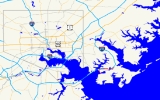
. Known as Bethlehem Boulevard, the state highway runs 2.35 miles (3.8 km) from Riverside Drive in Sparrows Point east to North Point Road in Edgemere
. MD 158 parallels Interstate 695
(I-695) along the northern edge of the former Bethlehem Steel
complex at Sparrows Point and connects MD 157
with MD 151
. Bethlehem Boulevard was constructed as a four-lane divided county highway with several interchanges in the late 1950s. The highway was designated MD 158 in the early 1990s. When I-695 was completely rebuilt and expanded from two to four lanes through Sparrows Point and Edgemere in the late 1990s, MD 158 was also reconstructed as a mostly two-lane highway without interchanges.
) on Bear Creek in Sparrows Point. The two-lane state highway curves east and closely parallels the northbound lanes of I-695 (Baltimore Beltway); the two highways are separated by a Jersey barrier
. After the highways cross mud flats, MD 158 veers away from the Beltway, expands to a four-lane divided highway, and receives a ramp from the northbound Interstate. The state highway meets the southern end of MD 157 (Peninsula Expressway), which provides access to southbound I-695, which heads toward the Francis Scott Key Bridge
. Beyond an entrance to the steel complex and a ramp to northbound I-695, the divided highway reduces to two lanes and again closely parallels the Beltway and meets the northern end of Wharf Road, which is unsigned MD 151B. The two highways curve northeast, then diverge as MD 158 temporarily becomes an undivided highway as it crosses over the Patapsco & Back Rivers Railroad. The state highway intersects MD 151 (North Point Boulevard) before reaching its eastern terminus at North Point Road, which heads south as the main street of Edgemere.
at modern US 40
north to Creswell Road near Riverside in Harford County
. This state highway was constructed by 1915 and removed from the state highway system in 1956. Bethlehem Boulevard was built as a four-lane divided highway between 1957 and 1959. The highway's original western terminus was at Dundalk Avenue, which crossed Bear Creek on a drawbridge from Dundalk
. Both the Dundalk Avenue bridge and the 1960-built Peninsula Expressway drawbridge were toll bridges through 1977; the Dundalk Avenue bridge was removed around 1985.
Bethlehem Boulevard was built with four interchanges. The western terminus of the highway was a trumpet interchange with Tin Mill Road (now Riverside Drive) where the mainline continued northwest as Dundalk Avenue across the drawbridge. Bethlehem Boulevard had a cloverleaf interchange with the Peninsula Expressway that featured a wide split in the median. East of the Peninsula Expressway interchange was a partial interchange with Wharf Road that offered access from Wharf Road to and from the west. The fourth junction was a partial interchange with MD 151 that allowed access between Bethlehem Boulevard to the west and MD 151 to the north. Eastbound Bethlehem Boulevard continued east to MD 20 (North Point Road). When MD 695 (now I-695) was completed as a two-lane freeway on a viaduct parallel to Bethlehem Boulevard from Edgemere to the Key Bridge in 1977, the only changes to the interchanges were two pairs of ramps from the west at the Peninsula Expressway interchange and from the east at the MD 151 interchange.
Bethlehem Boulevard was brought into the state highway system as MD 158 around 1991 concurrent with MD 157 being assigned to the Peninsula Expressway south of Bear Creek. Between 1995 and 1999, I-695 was transformed from a two-lane freeway on a viaduct to a four-lane surface-level freeway between Edgemere and the Key Bridge. As part of the project, MD 158 was reconstructed. Most of the state highway was reduced to two lanes and relocated parallel to I-695 instead of passing under the Interstate Highway. In addition, all four of MD 158's interchanges were removed. Westbound MD 158 at its interchange with MD 157 became a collector-distributor lane for westbound I-695's interchange with MD 157.
.
{|class=wikitable
!Location
!Mile
!Destinations
!Notes
|-
|rowspan=4|Sparrows Point
|0.00
|Riverside Drive
|Western terminus
|-
|1.07
|
|
|-
|1.20
|
|I-695 Exit 43
|-
|1.52
|Wharf Road south
|Unsigned MD 151B
|-
|rowspan=2|Edgemere
|2.21
|
|
|-
|2.35
|North Point Road
|Eastern terminus
State highway
State highway, state road or state route can refer to one of three related concepts, two of them related to a state or provincial government in a country that is divided into states or provinces :#A...
in the U.S. state of Maryland
Maryland
Maryland is a U.S. state located in the Mid Atlantic region of the United States, bordering Virginia, West Virginia, and the District of Columbia to its south and west; Pennsylvania to its north; and Delaware to its east...
. Known as Bethlehem Boulevard, the state highway runs 2.35 miles (3.8 km) from Riverside Drive in Sparrows Point east to North Point Road in Edgemere
Edgemere, Maryland
-Demographics:As of the census of 2000, there were 9,248 people, 3,530 households, and 2,513 families residing in the CDP. The population density was 855.6 people per square mile . There were 3,764 housing units at an average density of 348.2/sq mi...
. MD 158 parallels Interstate 695
Interstate 695 (Maryland)
Interstate 695 is a -long full beltway Interstate Highway extending around Baltimore, Maryland, USA. I-695 is officially designated the McKeldin Beltway, but is colloquially referred to as either the Baltimore Beltway or 695...
(I-695) along the northern edge of the former Bethlehem Steel
Bethlehem Steel
The Bethlehem Steel Corporation , based in Bethlehem, Pennsylvania, was once the second-largest steel producer in the United States, after Pittsburgh, Pennsylvania-based U.S. Steel. After a decline in the U.S...
complex at Sparrows Point and connects MD 157
Maryland Route 157
Maryland Route 157 is a state highway in the U.S. state of Maryland. The state highway runs from MD 158 in Sparrows Point north to North Point Road in Dundalk. MD 157 is an L-shaped highway serves as the primary highway through Dundalk and from Dundalk to Interstate 695...
with MD 151
Maryland Route 151
Maryland Route 151 is a state highway in the U.S. state of Maryland. Known for most of its length as North Point Boulevard, the state highway runs from 7th Street in Sparrows Point north to U.S. Route 1 in Baltimore...
. Bethlehem Boulevard was constructed as a four-lane divided county highway with several interchanges in the late 1950s. The highway was designated MD 158 in the early 1990s. When I-695 was completely rebuilt and expanded from two to four lanes through Sparrows Point and Edgemere in the late 1990s, MD 158 was also reconstructed as a mostly two-lane highway without interchanges.
Route description
MD 158 begins at a tangent intersection with Riverside Drive, which follows the western edge of the former Bethlehem Steel complex (now owned by SeverstalSeverstal
OAO Severstal Russian: Северсталь, "Northern Steel") is a Russian company mainly operating in the steel and mining industry, centred in the northern city of Cherepovets. Severstal is listed on the RTS and LSE. As of 2009, it is the largest steel company in Russia according to The Metal Bulletin....
) on Bear Creek in Sparrows Point. The two-lane state highway curves east and closely parallels the northbound lanes of I-695 (Baltimore Beltway); the two highways are separated by a Jersey barrier
Jersey barrier
A Jersey barrier or Jersey wall is a modular concrete barrier employed to separate lanes of traffic. It is designed to both minimize vehicle damage in cases of incidental contact while still preventing crossover in the case of head-on accidents....
. After the highways cross mud flats, MD 158 veers away from the Beltway, expands to a four-lane divided highway, and receives a ramp from the northbound Interstate. The state highway meets the southern end of MD 157 (Peninsula Expressway), which provides access to southbound I-695, which heads toward the Francis Scott Key Bridge
Francis Scott Key Bridge (Baltimore)
The Francis Scott Key Bridge, also known as the Outer Harbor Bridge or simply the Key Bridge, is a continuous truss bridge spanning the Patapsco River in Baltimore, Maryland, USA. The main span of is the third longest span of any continuous truss in the world.The bridge was opened in March 1977...
. Beyond an entrance to the steel complex and a ramp to northbound I-695, the divided highway reduces to two lanes and again closely parallels the Beltway and meets the northern end of Wharf Road, which is unsigned MD 151B. The two highways curve northeast, then diverge as MD 158 temporarily becomes an undivided highway as it crosses over the Patapsco & Back Rivers Railroad. The state highway intersects MD 151 (North Point Boulevard) before reaching its eastern terminus at North Point Road, which heads south as the main street of Edgemere.
History
The original MD 158 was Belcamp Road from the Bush RiverBush River (Maryland)
Bush River is a tidal estuary in Harford County, Maryland, located about 15 mi northeast of Baltimore. The estuary extends from the community of Riverside, south for about 9 mi , to the Chesapeake Bay...
at modern US 40
U.S. Route 40 in Maryland
U.S. Route 40 in the U.S. state of Maryland runs from western Maryland to Cecil County in the state's northeastern corner. With a total length of over , it is the longest numbered highway in Maryland. Almost half of the road overlaps with Interstate 68 or Interstate 70, while the old alignment...
north to Creswell Road near Riverside in Harford County
Harford County, Maryland
Harford County is a county in the U.S. state of Maryland. In 2010, its population was 244,826. Its county seat is Bel Air. Harford County forms part of the Baltimore-Washington Metropolitan Area.-History:...
. This state highway was constructed by 1915 and removed from the state highway system in 1956. Bethlehem Boulevard was built as a four-lane divided highway between 1957 and 1959. The highway's original western terminus was at Dundalk Avenue, which crossed Bear Creek on a drawbridge from Dundalk
Dundalk, Maryland
-Demographics:As of the census of 2000, there were 62,306 people, 24,772 households, and 16,968 families residing in the CDP. The population density was 4,689.5 people per square mile . There were 26,385 housing units at an average density of 1,985.9 per square mile...
. Both the Dundalk Avenue bridge and the 1960-built Peninsula Expressway drawbridge were toll bridges through 1977; the Dundalk Avenue bridge was removed around 1985.
Bethlehem Boulevard was built with four interchanges. The western terminus of the highway was a trumpet interchange with Tin Mill Road (now Riverside Drive) where the mainline continued northwest as Dundalk Avenue across the drawbridge. Bethlehem Boulevard had a cloverleaf interchange with the Peninsula Expressway that featured a wide split in the median. East of the Peninsula Expressway interchange was a partial interchange with Wharf Road that offered access from Wharf Road to and from the west. The fourth junction was a partial interchange with MD 151 that allowed access between Bethlehem Boulevard to the west and MD 151 to the north. Eastbound Bethlehem Boulevard continued east to MD 20 (North Point Road). When MD 695 (now I-695) was completed as a two-lane freeway on a viaduct parallel to Bethlehem Boulevard from Edgemere to the Key Bridge in 1977, the only changes to the interchanges were two pairs of ramps from the west at the Peninsula Expressway interchange and from the east at the MD 151 interchange.
Bethlehem Boulevard was brought into the state highway system as MD 158 around 1991 concurrent with MD 157 being assigned to the Peninsula Expressway south of Bear Creek. Between 1995 and 1999, I-695 was transformed from a two-lane freeway on a viaduct to a four-lane surface-level freeway between Edgemere and the Key Bridge. As part of the project, MD 158 was reconstructed. Most of the state highway was reduced to two lanes and relocated parallel to I-695 instead of passing under the Interstate Highway. In addition, all four of MD 158's interchanges were removed. Westbound MD 158 at its interchange with MD 157 became a collector-distributor lane for westbound I-695's interchange with MD 157.
Junction list
The entire route is in Baltimore CountyBaltimore County, Maryland
Baltimore County is a county located in the northern part of the US state of Maryland. In 2010, its population was 805,029. It is part of the Baltimore-Washington Metropolitan Area. Its county seat is Towson. The name of the county was derived from the barony of the Proprietor of the Maryland...
.
{|class=wikitable
!Location
!Mile
!Destinations
!Notes
|-
|rowspan=4|Sparrows Point
|0.00
|Riverside Drive
|Western terminus
|-
|1.07
|
|
|-
|1.20
|
|I-695 Exit 43
|-
|1.52
|Wharf Road south
|Unsigned MD 151B
|-
|rowspan=2|Edgemere
Edgemere, Maryland
-Demographics:As of the census of 2000, there were 9,248 people, 3,530 households, and 2,513 families residing in the CDP. The population density was 855.6 people per square mile . There were 3,764 housing units at an average density of 348.2/sq mi...
|2.21
|
|
|-
|2.35
|North Point Road
|Eastern terminus