
Maryland Route 147
Encyclopedia
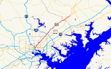
Maryland Route 147 is a state highway
in the U.S. state of Maryland
. Known as Harford Road, the state highway runs 18.81 miles (30.3 km) from U.S. Route 1
(US 1) in Baltimore north to US 1 and US 1 Business
in Benson
. MD 147 is an alternate route to US 1 between Baltimore and Bel Air, the county seat of Harford County
. The state highway is the main street of several neighborhoods in Northeast Baltimore and the Baltimore County
suburbs of Parkville
and Carney
. MD 147 is maintained by the Maryland State Highway Administration
in Baltimore and Harford counties and by the Baltimore City Department of Transportation within the city. Harford Road was a pair of turnpikes before the Baltimore–Carney portion of the highway was designated one of the original state roads. The Baltimore County section of MD 147 was constructed in the early 1910s and widened multiple times in the late 1920s and 1930s. The section of the state highway in Harford County was built in the late 1920s.
is accessed via southbound Aisquith a few blocks to the west. MD 147 heads northeast from US 1 as a five-lane road (three lanes northbound and two lanes southbound) that crosses over CSX
's Baltimore Terminal Subdivision. The state highway passes along the western edge of Clifton Park
, where the highway meets the southern ends of MD 542
(The Alameda) and MD 41
(Hillen Road). Within the Mayfield
neighborhood, MD 147 passes by Lake Montebello and through Herring Run Park, where the highway crosses the namesake stream. Beyond Argonne Drive, the state highway expands to six lanes and passes through Lauraville
, where the highway intersects Cold Spring Lane and Moravia Road. MD 147 reduces to four lanes and intersects Northern Parkway and the southern end of Old Harford Road in Hamilton before leaving the independent city
of Baltimore. MD 147 continues as the main street of Parkville, where the highway reduces to two travel lanes just north of Taylor Avenue. The state highway becomes four lanes again at Putty Hill Avenue and meets Interstate 695
(Baltimore Beltway) at a cloverleaf interchange
.
Outside of the Beltway, MD 147 gains a center turn lane through its intersection with Joppa Road in Carney, north of which the road reduces to two lanes. North of Cub Hill Road in the community of Cub Hill, the state highway leaves the suburban area and enters Gunpowder Falls State Park. MD 147 descends to Gunpowder Falls and makes a sharp curve to the east immediately north of the bridge over the stream. The state highway follows Gunpowder Falls and has a curvaceous ascent from the river valley before the roadway straightens out to pass through farmland with scattered subdivisions. MD 147 crosses Long Green Creek and has a sharp S-curve around a hill before intersecting Glen Arm Road. The state highway continues through the community of Fork
, at the center of which the highway meets Fork Road and Sunshine Avenue. East of Fork, MD 147 descends into the valley of Little Gunpowder Falls, which forms the Baltimore–Harford county line. The state highway continues northeast and crosses Rocky Branch before its intersection with MD 152
(Fallston Road). MD 147 heads into the community of Benson, the site of its northern terminus at a four-way intersection with US 1 and US 1 Business. US 1 heads north as the Bel Air Bypass and south as Belair Road, while US 1 Business heads east on Belair Road into the town of Bel Air.
The old turnpike along what is now Harford Road was resurfaced from Taylor Avenue northeast to Little Gunpowder Falls by 1915. The Harford County portion of Harford Road was reconstructed starting in 1926. The highway was completed as a macadam road from US 1 in Benson west to Rocky Branch in 1927. The remainder of Harford Road south to Little Gunpowder Falls was built as a concrete road in 1928. By 1930, the portion of Harford Road in Baltimore city and county was widened to a width of 20 feet (6.1 m). Harford Road was marked as MD 147 by 1933. Between 1936 and 1938, the tracks of a defunct interurban
were removed and the space used to widen MD 147 to a width of 46 feet (14 m) from the Baltimore city line to Carney. That portion of MD 147 was widened again with the addition of a 7 feet (2.1 m) wide concrete shoulder around 1940.
!County
!Location
!Mile
!Destinations
!Notes
|-
|rowspan=5 colspan=2|Baltimore City
|0.00
|
|Southern terminus
|-
|0.80
|
|
|-
|0.96
|
|
|-
|2.76
|Cold Spring Lane west / Moravia Road south
|
|-
|4.44
|Northern Parkway
|
|-
|rowspan=2|Baltimore
|Parkville
|6.53
|
|I-695 Exit 31
|-
|Carney
|7.12
|Joppa Road
|
|-
|rowspan=2|Harford
|rowspan=2|Benson
|17.72
|
|
|-
|18.81
|
|Northern terminus
State highway
State highway, state road or state route can refer to one of three related concepts, two of them related to a state or provincial government in a country that is divided into states or provinces :#A...
in the U.S. state of Maryland
Maryland
Maryland is a U.S. state located in the Mid Atlantic region of the United States, bordering Virginia, West Virginia, and the District of Columbia to its south and west; Pennsylvania to its north; and Delaware to its east...
. Known as Harford Road, the state highway runs 18.81 miles (30.3 km) from U.S. Route 1
U.S. Route 1 in Maryland
U.S. Route 1 is the easternmost and longest of the major north–south routes of the United States Numbered Highway System, running from Key West, Florida to Fort Kent, Maine. In the U.S...
(US 1) in Baltimore north to US 1 and US 1 Business
U.S. Route 1 Business (Bel Air, Maryland)
U.S. Route 1 Business is a business route of U.S. Route 1 in the U.S. state of Maryland. The highway runs from US 1 and Maryland Route 147 in Benson north to US 1 near Hickory. US 1 Business is the old alignment of US 1 through Bel Air, the county seat of Harford County. US 1 was originally...
in Benson
Benson, Harford County, Maryland
Benson is an unincorporated community in Harford County, Maryland, United States. Benson is located at the junction of U.S. Route 1 and Maryland Route 147 southwest of Bel Air. Benson has a post office with ZIP code 21018....
. MD 147 is an alternate route to US 1 between Baltimore and Bel Air, the county seat of Harford County
Harford County, Maryland
Harford County is a county in the U.S. state of Maryland. In 2010, its population was 244,826. Its county seat is Bel Air. Harford County forms part of the Baltimore-Washington Metropolitan Area.-History:...
. The state highway is the main street of several neighborhoods in Northeast Baltimore and the Baltimore County
Baltimore County, Maryland
Baltimore County is a county located in the northern part of the US state of Maryland. In 2010, its population was 805,029. It is part of the Baltimore-Washington Metropolitan Area. Its county seat is Towson. The name of the county was derived from the barony of the Proprietor of the Maryland...
suburbs of Parkville
Parkville, Maryland
-Demographics:As of the census of 2000, there were 31,118 people, 13,044 households, and 8,243 families residing in the CDP. The population density was 7,352.1 people per square mile . There were 13,550 housing units at an average density of 3,201.4 per square mile...
and Carney
Carney, Maryland
Carney is an unincorporated community and a census-designated place in Baltimore County, Maryland, United States. The population was 28,264 at the 2000 census.-Geography:Carney is located at ....
. MD 147 is maintained by the Maryland State Highway Administration
Maryland State Highway Administration
The Maryland State Highway Administration is the state agency responsible for maintaining Maryland numbered highways outside of Baltimore City...
in Baltimore and Harford counties and by the Baltimore City Department of Transportation within the city. Harford Road was a pair of turnpikes before the Baltimore–Carney portion of the highway was designated one of the original state roads. The Baltimore County section of MD 147 was constructed in the early 1910s and widened multiple times in the late 1920s and 1930s. The section of the state highway in Harford County was built in the late 1920s.
Route description
MD 147 begins at an intersection with US 1 (North Avenue) in Baltimore. The south leg of the intersection is one-way northbound Harford Avenue; southbound Harford Avenue toward Downtown BaltimoreDowntown Baltimore
Downtown Baltimore is the section of Baltimore traditionally bounded by Martin Luther King, Jr. Boulevard to the west, Mt. Royal Avenue to the north, President Street to the east and the Inner Harbor area to the south. It consists of four neighborhoods: Westside, City Centre, Inner Harbor, and...
is accessed via southbound Aisquith a few blocks to the west. MD 147 heads northeast from US 1 as a five-lane road (three lanes northbound and two lanes southbound) that crosses over CSX
CSX Transportation
CSX Transportation operates a Class I railroad in the United States known as the CSX Railroad. It is the main subsidiary of the CSX Corporation. The company is headquartered in Jacksonville, Florida, and owns approximately 21,000 route miles...
's Baltimore Terminal Subdivision. The state highway passes along the western edge of Clifton Park
Clifton Park, Baltimore
Clifton Park is a public urban park located in the Belair-Edison neighborhood in the northeast section of Baltimore, Maryland. USA. It is roughly bordered by Erdman Avenue to the northeast, Sinclair Lane to the south, Harford Road to the northwest and Belair Road to the southeast...
, where the highway meets the southern ends of MD 542
Maryland Route 542
Maryland Route 542 is a state highway in the U.S. state of Maryland. Known for most of its length as Loch Raven Boulevard, the state highway runs from MD 147 in Baltimore north to Interstate 695 and Cromwell Bridge Road near Towson. MD 542 is a four-lane divided highway that connects portions...
(The Alameda) and MD 41
Maryland Route 41
Maryland Route 41 is a state highway in the U.S. state of Maryland. Known for most of its length as Perring Parkway, the state highway runs from MD 147 in Baltimore north to Waltham Woods Road in Carney. MD 41 is a four- to six-lane divided highway that connects portions of Northeast Baltimore,...
(Hillen Road). Within the Mayfield
Mayfield, Baltimore
Mayfield is a small community in northeast Baltimore, Maryland. It is bounded by Erdman Avenue on the south, Chesterfield Avenue on the north, Crossland Avenue on the east and Lake Montebello on the north and west...
neighborhood, MD 147 passes by Lake Montebello and through Herring Run Park, where the highway crosses the namesake stream. Beyond Argonne Drive, the state highway expands to six lanes and passes through Lauraville
Lauraville, Baltimore
Lauraville is a neighborhood located in northeast Baltimore, Maryland. The neighborhood is bounded on the east by Harford Road, on the north by Echodale Avenue, on the south by Argonne Drive and Herring Run Park, and on the west side by Mount Pleasant Park and Morgan State University, with East...
, where the highway intersects Cold Spring Lane and Moravia Road. MD 147 reduces to four lanes and intersects Northern Parkway and the southern end of Old Harford Road in Hamilton before leaving the independent city
Independent city
An independent city is a city that does not form part of another general-purpose local government entity. These type of cities should not be confused with city-states , which are fully sovereign cities that are not part of any other sovereign state.-Historical precursors:In the Holy Roman Empire,...
of Baltimore. MD 147 continues as the main street of Parkville, where the highway reduces to two travel lanes just north of Taylor Avenue. The state highway becomes four lanes again at Putty Hill Avenue and meets Interstate 695
Interstate 695 (Maryland)
Interstate 695 is a -long full beltway Interstate Highway extending around Baltimore, Maryland, USA. I-695 is officially designated the McKeldin Beltway, but is colloquially referred to as either the Baltimore Beltway or 695...
(Baltimore Beltway) at a cloverleaf interchange
Cloverleaf interchange
A cloverleaf interchange is a two-level interchange in which left turns, reverse direction in left-driving regions, are handled by ramp roads...
.
Outside of the Beltway, MD 147 gains a center turn lane through its intersection with Joppa Road in Carney, north of which the road reduces to two lanes. North of Cub Hill Road in the community of Cub Hill, the state highway leaves the suburban area and enters Gunpowder Falls State Park. MD 147 descends to Gunpowder Falls and makes a sharp curve to the east immediately north of the bridge over the stream. The state highway follows Gunpowder Falls and has a curvaceous ascent from the river valley before the roadway straightens out to pass through farmland with scattered subdivisions. MD 147 crosses Long Green Creek and has a sharp S-curve around a hill before intersecting Glen Arm Road. The state highway continues through the community of Fork
Fork, Maryland
Fork is an unincorporated community in Baltimore County, Maryland, United States....
, at the center of which the highway meets Fork Road and Sunshine Avenue. East of Fork, MD 147 descends into the valley of Little Gunpowder Falls, which forms the Baltimore–Harford county line. The state highway continues northeast and crosses Rocky Branch before its intersection with MD 152
Maryland Route 152
Maryland Route 152 is a state highway in the U.S. state of Maryland. The state highway runs from an entrance to Aberdeen Proving Ground in Magnolia north to MD 146 near Taylor. MD 152 parallels the western edge of Harford County, connecting the communities of Joppatowne and Fallston with...
(Fallston Road). MD 147 heads into the community of Benson, the site of its northern terminus at a four-way intersection with US 1 and US 1 Business. US 1 heads north as the Bel Air Bypass and south as Belair Road, while US 1 Business heads east on Belair Road into the town of Bel Air.
History
MD 147's predecessor route was followed by a pair of turnpikes in the 19th century: the Baltimore and Harford Turnpike from Baltimore to the county line at Little Gunpowder Falls, and the Harford Turnpike from there to the Baltimore and Bel Air Turnpike at the spot 2.5 miles (4 km) west of Bel Air that became the community of Benson. The portion of Harford Road from North Avenue in Baltimore to Cub Hill was designated one of the original state roads by the Maryland State Roads Commission in 1909. The proposed state road continued along what are today a series of county routes: Cub Hill Road, Glen Arm Road, and Manor Road to its intersection with Long Green Road in the community of Unionville or Long Green. Harford Road was under construction by 1911 from North Avenue to Taylor Avenue and completed in 1912. From North Avenue to the old city limits near Lake Montebello, Harford Road was reconstructed with a 50 feet (15.2 m) vitrified brick surface. From the city limits to Taylor Avenue, the highway was built with a 15 to 18 ft (4.6 to 5.5 m) wide tarred macadam surface.The old turnpike along what is now Harford Road was resurfaced from Taylor Avenue northeast to Little Gunpowder Falls by 1915. The Harford County portion of Harford Road was reconstructed starting in 1926. The highway was completed as a macadam road from US 1 in Benson west to Rocky Branch in 1927. The remainder of Harford Road south to Little Gunpowder Falls was built as a concrete road in 1928. By 1930, the portion of Harford Road in Baltimore city and county was widened to a width of 20 feet (6.1 m). Harford Road was marked as MD 147 by 1933. Between 1936 and 1938, the tracks of a defunct interurban
Interurban
An interurban, also called a radial railway in parts of Canada, is a type of electric passenger railroad; in short a hybrid between tram and train. Interurbans enjoyed widespread popularity in the first three decades of the twentieth century in North America. Until the early 1920s, most roads were...
were removed and the space used to widen MD 147 to a width of 46 feet (14 m) from the Baltimore city line to Carney. That portion of MD 147 was widened again with the addition of a 7 feet (2.1 m) wide concrete shoulder around 1940.
Junction list
{|class=wikitable!County
!Location
!Mile
!Destinations
!Notes
|-
|rowspan=5 colspan=2|Baltimore City
|0.00
|
|Southern terminus
|-
|0.80
|
|
|-
|0.96
|
|
|-
|2.76
|Cold Spring Lane west / Moravia Road south
|
|-
|4.44
|Northern Parkway
|
|-
|rowspan=2|Baltimore
Baltimore County, Maryland
Baltimore County is a county located in the northern part of the US state of Maryland. In 2010, its population was 805,029. It is part of the Baltimore-Washington Metropolitan Area. Its county seat is Towson. The name of the county was derived from the barony of the Proprietor of the Maryland...
|Parkville
Parkville, Maryland
-Demographics:As of the census of 2000, there were 31,118 people, 13,044 households, and 8,243 families residing in the CDP. The population density was 7,352.1 people per square mile . There were 13,550 housing units at an average density of 3,201.4 per square mile...
|6.53
|
|I-695 Exit 31
|-
|Carney
Carney, Maryland
Carney is an unincorporated community and a census-designated place in Baltimore County, Maryland, United States. The population was 28,264 at the 2000 census.-Geography:Carney is located at ....
|7.12
|Joppa Road
|
|-
|rowspan=2|Harford
Harford County, Maryland
Harford County is a county in the U.S. state of Maryland. In 2010, its population was 244,826. Its county seat is Bel Air. Harford County forms part of the Baltimore-Washington Metropolitan Area.-History:...
|rowspan=2|Benson
Benson, Harford County, Maryland
Benson is an unincorporated community in Harford County, Maryland, United States. Benson is located at the junction of U.S. Route 1 and Maryland Route 147 southwest of Bel Air. Benson has a post office with ZIP code 21018....
|17.72
|
|
|-
|18.81
|
|Northern terminus