
.gif)
Interstate 695 (Maryland)
Encyclopedia
Interstate 695 is a 51.46 miles (82.8 km)-long full beltway Interstate Highway extending around Baltimore, Maryland, USA. I-695 is officially designated the McKeldin Beltway, but is colloquially referred to as either the Baltimore Beltway or 695. The route is an auxiliary route of Interstate 95
, intersecting that route southwest of Baltimore near Arbutus
and northeast of the city near White Marsh
. It also intersects other major roads radiating from the Baltimore area, including Interstate 97
near Glen Burnie
, the Baltimore–Washington Parkway (Maryland Route 295) near Linthicum
, Interstate 70
near Woodlawn
, Interstate 795
near Pikesville
, and Interstate 83
in the Timonium area. The 19.37 miles (31.2 km) portion of the Baltimore Beltway between I-95 northeast of Baltimore and I-97 south of Baltimore is officially Maryland Route 695, and is not part of the Interstate Highway System, but is signed as I-695. This section of the route includes the Francis Scott Key Bridge
that crosses over the Patapsco River
. The bridge and its approaches are maintained by the Maryland Transportation Authority
while the remainder of the Baltimore Beltway is maintained by the Maryland State Highway Administration
.
The Baltimore Beltway was first planned in 1949 by Baltimore County
; the state eventually took over the project and it became part of the Interstate Highway System planned in 1956. The length of the route from Maryland Route 2
south of Baltimore clockwise to U.S. Route 40
northeast of the city opened in stages from 1955 to 1962, providing an Interstate bypass of Baltimore. It was the first beltway in the United States to be built as part of the Interstate Highway System. Plans were made to finish the remainder of the route, with a diversion to the Windlass Freeway and the Patapsco Freeway, opened in 1973, following the cancellation of a more outer route that was to partly follow what is today Maryland Route 702
(Southeast Boulevard). The Outer Harbor Crossing over the Patapsco River, which was dedicated to Francis Scott Key
, who wrote The Star-Spangled Banner
, and its approaches were finished in 1977, completing the route around Baltimore. The approaches to the bridge were originally two lanes to accommodate a tunnel that was originally proposed to run under the river; in subsequent years, they were upgraded to a four-lane configuration compliant with Interstate Highway standards
, allowing for this portion of route to be signed as I-695 rather than MD 695. There are future plans for I-695 that include express toll lanes to ease traffic. In addition, the northeastern interchange with I-95 is currently being reconstructed to accommodate express toll lanes that are to be added to I-95.
, is four lanes wide. The route passes over Curtis Creek
on a pair of drawbridge
s here, which have 58 feet (17.7 m) of vertical navigational clearance and provide access for tall ships to a U.S. Coast Guard base further upstream. Continuing west through industrial areas into Anne Arundel County
, the route encounters the northern terminus of Maryland Route 10
(Arundel Expressway) at a directional interchange, where maintenance switches to the Maryland State Highway Administration
. The interchange includes access to the next interchange, with Maryland Route 2
(Ritchie Highway), a major north–south route between Baltimore and the southern suburbs, in Glen Burnie
. This interchange has access to northbound MD 2 in both directions and from northbound MD 2 to the westbound direction. Beyond MD 2, I-695 encounters Interstate 895 Spur, a short connector to Interstate 895
(Harbor Tunnel Thruway); this interchange provides access to southbound MD 2 from both directions and to the eastbound direction from southbound MD 2. Immediately past this interchange, I-695 comes to an interchange with the northern terminus of Interstate 97
, which terminates on the Beltway. At this point, the route officially becomes I-695.
The route continues west as a six-lane 55 mph (88.5 km/h) freeway, heading west into residential areas of Linthicum
. It interchanges with Maryland Route 648
(Baltimore Annapolis Boulevard), where 132,330 vehicles travel I-695 every day, before turning northwest and intersecting Maryland Route 170
(Camp Meade Road). The route encounters the Baltimore–Washington Parkway (Maryland Route 295) at a cloverleaf interchange
where the route’s signage changes from east–west to north–south at this interchange. It turns more to the north from here and heads into commercial areas, interchanging with Maryland Route 168
(Nursery Road) and Hammonds Ferry Road. Past this interchange, the route crosses the Patapsco River
into Baltimore County
and soon encounters a partial interchange with Interstate 895 (Harbor Tunnel Thruway) with access only from the southbound direction of I-695 to I-895 northbound and from I-895 southbound to the northbound direction of I-695. Past this interchange, I-695 heads north, interchanging with Hollins Ferry Road in Lansdowne
before passing under CSX’s Baltimore Terminal Subdivision and coming to an interchange with U.S. Route 1 Alternate (Washington Boulevard) in Arbutus
. A short distance later, I-695 comes to a semidirectional interchange with Interstate 95
.
Along this portion of I-695, the daily traffic counts range from a high of 134,095 vehicles at the interchange with MD 170 in Linthicum to a low of 43,100 vehicles at the Curtis Creek drawbridge in 2007.
’s Northeast Corridor
and comes to a partial interchange with U.S. Route 1
(Southwestern Boulevard), with a southbound exit and northbound entrance. From here, it continues northwest through residential areas of Catonsville
to an interchange with Maryland Route 372
(Wilkens Avenue). Narrowing to eight lanes total, with four lanes in each direction, beyond MD 372, the route continues through suburban neighborhoods before coming to an interchange with Maryland Route 144
(Frederick Road). At this point, I-695 narrows to seven lanes, with three southbound lanes and four northbound lanes. It continues north and interchanges with Edmondson Avenue before turning northwest and intersects U.S. Route 40
(Baltimore National Pike) near the defunct Westview Mall
, now a big-box complex. Beyond US 40, I-695 continues north through residential areas, narrowing to six lanes, with three lanes in each direction, before coming to a four-level stack interchange
with Interstate 70
in Woodlawn
.
Along this portion of I-695, the daily traffic counts range from a high of 216,940 vehicles at the interchange with I-70 in Woodlawn to a low of 179,390 vehicles at the interchange with I-95 in Arbutus in 2007.
(Security Boulevard), located near the Security Square Mall
and the headquarters of the Social Security Administration
. Continuing north, the road widens to eight lanes again and continues through a mix of suburban homes and business parks in Lochearn
. I-695 interchanges with Maryland Route 26
(Liberty Road) east of Randallstown
and resumes north, narrowing to six lanes. It intersects the southern terminus of Interstate 795
(Northwest Expressway), which serves as a bypass of Maryland Route 140
in the Owings Mills
area. The Baltimore Metro
's line to Owings Mills passes under I-695 within the interchange and runs in the median of I-795 as far as that town. At the I-795 interchange, the signage of route changes from north–south to east–west.
 From here, I-695 heads northeast as an eight lane road and enters Pikesville
, where it intersects MD 140 (Reisterstown Road) at a single-point urban interchange
. A short distance later, the road comes to a partial interchange with Maryland Route 129
(Park Heights Avenue), with an eastbound exit and westbound entrance. I-695 heads east to another partial interchange with Stevenson Road, which has a westbound exit and eastbound entrance. The Baltimore Beltway passes through heavily forested land as it encounters Greenspring Avenue
. Past this interchange, I-695 continues northeast through woodland before coming to an interchange with Interstate 83
(Jones Falls Expressway). The interchange includes connections to Maryland Route 25
(Falls Road), which heads into the open countryside north of Baltimore. Within this interchange, I-83 forms a concurrency
with I-695 and the roadway widens to ten lanes, with six for the Beltway and four for I-83. After running concurrently, I-83 splits from I-695 by heading north on the Harrisburg Expressway at a directional interchange.
Along this portion of I-695, the daily traffic counts range from a high of 228,300 vehicles along the I-83 concurrency to a low of 180,080 vehicles at the interchange with MD 129 in Pikesville in 2007.
, interchanging with Maryland Route 139
(Charles Street). The Baltimore Beltway heads through residential and commercial areas before coming to interchanges with Maryland Route 45
(York Road) near The Shops at Kenilworth
and Maryland Route 146
(Dulaney Valley Road). Continuing east, the Baltimore Beltway passes to the north of Goucher College
and comes to an interchange with Providence Road. I-695 turns southeast through residential areas past Providence Road and comes to an interchange with Maryland Route 542
(Loch Raven Boulevard) and Cromwell Bridge Road
. The road continues towards Parkville
, where it comes to a cloverleaf interchange with Maryland Route 41
(Perring Parkway) within commercial areas. The Baltimore Beltway continues through residential areas into Carney
, coming to another cloverleaf interchange with Maryland Route 147
(Harford Road). Continuing east into White Marsh
, the route encounters the western terminus of Maryland Route 43
(White Marsh Boulevard), a limited-access at-grade boulevard that provides access to White Marsh Mall
, US 1 and I-95.
I-695 turns south past MD 43 and interchanges with US 1 (Belair Road) south of White Marsh. The road continues southeast to an interchange with I-95 (John F. Kennedy Memorial Highway) a short distance after US 1 in Rossville
. This interchange with I-95 (to east of Baltimore city) is a fully directional interchange where the carriageways of both routes crossed over each other onto the opposite side, then crossed over each other again; at the site of each crossover, left-hand entrance and exit ramps were provided to eliminate the need for directional flyovers. In 2008, interchange reconstruction at the I-95 interchange removed the left-hand entrance from northbound I-95 to westbound I-695 with the remaining left-hand entrances to be removed by August 2009 as part of the construction of the I-95 Express Toll Lane Project; all exits and entrances were now on the right, and I-95's opposing roadways no longer crossed each other (but I-695's still did).
Along this portion of I-695, the daily traffic counts range from a high of 180,930 vehicles at the east end of the I-83 concurrency in Lutherville to a low of 110,143 vehicles at the interchange with I-95 in Rossville in 2007.
(Philadelphia Road). Between I-95 and MD 7, the route’s changes from east–west to north–south. Immediately after MD 7, the route interchanges with US 40 (Pulaski Highway) northwest of Essex
near The Centre at Golden Ring
. After US 40, I-695 crosses over CSX’s Philadelphia Subdivision and comes to a partial directional interchange with Maryland Route 702
(Southeast Boulevard). At this interchange, I-695 turns south onto the Windlass Freeway, crossing over the Northeast Corridor again within the interchange.
Running south along the Windlass Freeway, parallel to the Northeast Corridor, I-695, now narrowed to four lanes, turns west before making a sharp turn to the south, crossing over the railroad line twice. The road becomes the Patapsco Freeway and continues south to an interchange with Maryland Route 150
(Eastern Avenue) and Maryland Route 157
(Merritt Boulevard) near the Eastpoint Mall
. A short distance later, I-695 comes to an interchange with Maryland Route 151
(North Point Boulevard). From here, the route continues southeast along the Back River
into residential and industrial Dundalk
, interchanging with Cove Road. The route turns south, with the median briefly widening to include trees, before coming to another interchange with MD 151. Past MD 151, the Baltimore Beltway continues southwest through industrial areas, with maintenance switching to the Maryland Transportation Authority at the crossing of a CSX rail line. It comes to an interchange with MD 157 (Peninsula Expressway) and Maryland Route 158
(Bethlehem Boulevard) before heading west. The route runs past the Sparrows Point Industrial Complex before crossing over Bear Creek and interchanging with unsigned Maryland Route 695A (Broening Highway) south of the Dundalk Marine Terminal.
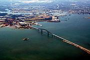 Beyond this interchange, the route comes to two-way toll plaza and ascends onto the Francis Scott Key Bridge
, which carries I-695 over the lower Baltimore Harbor and Patapsco River
. Unlike the Fort McHenry or Harbor Tunnels, HAZMAT
trucks are allowed to cross the Key Bridge. After crossing the Patapsco River over the bridge the route touches down within the Baltimore city limits and continues west through industrial areas. It comes to an interchange with Quarantine Road, which provides access to Maryland Route 173
, south of Curtis Bay
. By this point, the route’s signage changes from north–south to east–west. Past this interchange, the Baltimore Beltway continues west and returns to the Curtis Creek
drawbridges.
Along this portion of I-695, the daily traffic counts range from a high of 99,210 vehicles at the interchange with MD 7 in Rosedale to a low of 21,970 vehicles at exit 42 (MD 151) in Dundalk in 2007.
(Capital Beltway) around Washington, D.C.
, on which exit numbers are generally arranged by mileposts counterclockwise starting at the southern crossing of the Potomac River, the exit numbers for the Baltimore Beltway are arranged consecutively clockwise starting at Interchange #1 at Quarantine Rd, west of the Francis Scott Key Bridge crossing of the Patapsco River.
by 1956, increasing the speed of construction due to federal funds available.
The first part of the Baltimore Beltway to be completed was in December 1955 between MD 25 (Falls Road) and the Harrisburg Expressway (present-day I-83). In 1956, the next portion of the road between the Harrisburg Expressway and MD 45 (York Road) opened. Several more segments of the Baltimore Beltway would be built in the following years, with the section from MD 168 (Nursery Road) to the Glen Burnie Bypass (present-day I-97) opening in 1957; the portions from MD 45 to MD 542 (Loch Raven Boulevard), MD 7 (Old Philadelphia Road) to US 40 (Pulaski Highway), and from MD 168 to US 40 (Baltimore National Pike) opening in 1958; the segment from MD 2 (Ritchie Highway) to the Glen Burnie Bypass completed in 1960; the portion from US 1 (Belair Road) to MD 7 finished in 1961; and the portions from MD 542 to US 1 and from US 40 to MD 25 finished in 1962. At this time, the original length of the Baltimore Beltway, from MD 2 in the south clockwise to US 40 in the northeast, was fully completed and opened to traffic, providing the first Interstate-grade bypass of Baltimore and the first beltway in the United States built under the Interstate Highway System. A segment of the road completed in 1973 ran from MD 10 to MD 2, heading toward the Outer Harbor Crossing.
. Part of this alignment was completed south of US 40 in 1972 with a further extension to MD 150 opening as the Southeast Freeway (designated MD 702) by 1975. However, the Baltimore Beltway was diverted to two freeways not planned to be part of it. The first was the Windlass Freeway (Maryland Route 149), a route planned to run from I-95 at Moravia Road northeast to Chase
, paralleling US 40 to the south. The other freeway that was incorporated into the Baltimore Beltway was the Patapsco Freeway, a short connector from the Windlass Freeway southeast to the originally-planned Baltimore Beltway. Only the segment of the Windlass Freeway between MD 702 the planned intersection with the Patapsco Freeway south to MD 151 (North Point Boulevard) were constructed, opening to traffic in 1973.
Ramp stubs for the planned Windlass Freeway are present at the proposed west end at I-95 and Moravia Road, and at the present east end at the Southeast Freeway. The junction of the Windlass and Patapsco Freeways was originally built with provisions for extensions of each, but this has since been reconstructed.
Construction on the Outer Harbor Crossing, including the bridge, started in 1972 and was completed on March 23, 1977, completing the full Baltimore Beltway. The bridge was named the Francis Scott Key Bridge in honor of Francis Scott Key
, who wrote "The Star-Spangled Banner
," the national anthem
of the United States. By the early 1980s, the southern approach to the Key Bridge was dualized, with a second roadway constructed along with a second drawbridge over Curtis Creek. The northern approach was left as a two-lane viaduct in the Sparrows Point
area until a four-lane surface freeway was constructed along this portion, with interchanges reconfigured, following an $89.5 million project completed in January 2000. The Outer Harbor Crossing, as well as the entire Baltimore Beltway east of I-95, was first signposted as MD 695 because portions of it were a two-lane expressway not up to Interstate Highway standards
. Improvements to the road have allowed the entire Baltimore Beltway to be signed as I-695, even though all of I-695 between the junction of I-95 northeast of Baltimore and I-97 is officially considered MD 695 by the MDSHA.
. The footbridge had been closed to pedestrians since November 1996 due to complaints about vandalism and crime.
At Exit 33 (I-95/John F. Kennedy Memorial Highway), both highways cross over themselves so that all through traffic is on the left side of the road with left-hand entrance/exit ramps connecting the crossover sections. This interchange is currently being replaced by a more conventional flyover ramp interchange, as part of the I-95 expansion project under construction since 2007, eliminating the left-turn ramps and double crossovers. So far, several ramps have been completed, with the ramp from northbound I-95 to eastbound I-695 completed in September 2008, the ramp from westbound I-695 to northbound I-95 completed in October 2008, the ramp from northbound I-95 to westbound I-695 completed in November 2008 (eliminating the left-hand exit), and the ramp from eastbound I-695 to southbound I-95 was completed in May 2009. The ramps from southbound I-95 to both westbound and eastbound I-695 were completed in June 2009 and the ramp from westbound I-695 to southbound I-695 was completed in July 2009 and the ramp from eastbound I-695 to northbound I-95 opened in August 2009. In addition to rebuilding these ramps, the project will also add four ramps to service the express toll lanes being added to I-95.
There are long-term plans to add express toll lanes to I-695 to ease traffic congestion along the route. In addition, there are also plans to widen the portion of I-695 between I-83 and I-95 to the north of Baltimore. This road, which is to be widened to eight lanes, is currently in the design phase.
(inner loop) direction, in accordance with AASHTO guidelines.
{|class=wikitable
!County
!Location
!Mile
!Exit
!Destinations
!Notes
|-
|rowspan=10|Anne Arundel
|rowspan=5|Glen Burnie
|0.00
|colspan=3 align="center"|Curtis Creek Drawbridge over Curtis Creek
|-
|rowspan=2|0.76
|2
|
|
|-
|colspan=5 align="center"|Maintenance changes from MdTA
to MDSHA
|-
|1.67
|3A
|
|Access from I-695 east to MD 2 provided by MD 711.
|-
|2.17
|3B
|
|Access from I-695 east to MD 2 south and from MD 2 north to I-695 west provided by I-895B
.
|-
|Ferndale
|2.48
|4
|
|
|-
|rowspan=4|Linthicum
|3.24
|5
|
|
|-
|3.72
|6
|
|Eastbound exit, westbound entrance; split into exits 6A (North Linthicum) and 6B (Linthicum).
|-
|4.54
|7
|, Washington
|Split into exits 7A (Baltimore) and 7B (Washington).
|-
|4.92
|8
|
|Access between I-695 north and MD 168 provided by MD 969A.
|-
|rowspan=44|Baltimore
|rowspan=2|Lansdowne
|5.61
|8A
|
|Access from I-695 south to I-895 north and from I-895 south to I-695 north.
|-
|5.84
|9
|Hollins Ferry Road – Lansdowne
|Former MD 891
|-
|rowspan=3|Arbutus
|6.53
|10
|
|The exit from I-695 south to US 1 Alt. splits from exit 11B.
|-
|6.99
|11
|, Washington
|Split into exits 11A (Baltimore) and 11B (Washington).
|-
|7.76
|12A
|
|Inner Loop exit, Outer Loop entrance
|-
|rowspan=4|Catonsville
|8.72
|12
|
|Split into exits 12B (east) and 12C (west)
|-
|9.96
|13
|
|
|-
|10.44
|14
|Edmondson Avenue
|
|-
|11.19
|15
|
|Split into exits 15A (Baltimore) and 15B (Ellicot City).
|-
|rowspan=2|Woodlawn
|12.60
|16
|, Local Traffic
|Split into exits 16A (Local Traffic) and 16B (Frederick).
|-
|13.06
|17
| - Woodlawn
|
|-
|Lochearn
|15.60
|18
|
|Split into exits 18A (Lochearn) and 18B (Randallstown)
|-
|rowspan=4|Pikesville
|17.40
|19
|
|
|-
|18.37
|20
|
|
|-
|19.11
19.60
|21
|
|The two halves of this interchange, at MD 129 and Stevenson Road, are connected by MD 129A
.
|-
|21.01
|22
|Greenspring Avenue
|-
|rowspan=2|Brooklandville
|rowspan=2|22.74
|23A
|
|West end of concurrency with I-83
|-
|23B
|
|Traffic uses MD 25A
between I-695 and MD 25.
|-
|rowspan=2|Lutherville
|24.26
|24
|, York, PA
|East end of concurrency with I-83
|-
|24.88
|25
|
|
|-
|rowspan=5|Towson
|25.90
|26
|
|Split into exits 26A (Towson) and 26B (Lutherville) eastbound; access between I-695 eastbound and MD 45 south provided by MD 45A
.
|-
|26.53
|27
|
|Split into exits 27A (Towson) and 27B (north)
|-
|27.78
|28
|Providence Road
|
|-
|28.52
|29A
|Cromwell Bridge Road
|Former MD 567
|-
|28.69
|29B
|
|Exits 29A and 29B are combined on I-695 outer.
|-
|Parkville
|29.75
|30
|
|Split into exits 30A (south) and 30B (north)
|-
|Carney
|30.89
|31
|
|Split into exits 31A (Parkville) and 31B (Carney)
|-
|rowspan=2|Overlea
|31.35
|31C
|
|Eastbound exit, westbound entrance
|-
|32.52
|32
|
|Split into exits 32A (Overlea) and 32B (Bel Air)
|-
|Rossville
|34.07
|33
|
|Split into exits 33A (Baltimore, Washington) and 33B (New York)
|-
|rowspan=2|Rosedale
|35.26
|34
|
|
|-
|35.60
|35
|
|Split into exits 35A (Baltimore) and 35B (Aberdeen)
|-
|Essex
|35.95
|36
|
|
|-
|rowspan=11|Dundalk
|38.73
|38
|
|Split into exits 38A (Baltimore) and 38B (Essex) southbound; no access from northbound I-695 to westbound MD 150 or from eastbound MD 150 to southbound I-695
|-
|39.09
|39
|
|Southbound exit, northbound entrance
|-
|39.35
|rowspan=2|40
|
|Northbound exit, southbound entrance
|-
|40.05
|
|Southbound exit, northbound entrance
|-
|41.08
|41
|
|
|-
|43.56
|42
|
|Southbound exit, northbound entrance
|-
|43.81
|colspan=4 align="center"|Maintenance changes from MDSHA
to MdTA
at the east end of the bridge over a CSX Transportation
line.
|-
|44.74
|43
|
|
|-
|46.51
|44
|Broening Highway (MD 695A)
|Northbound exit, southbound entrance
|-
|46.92
|colspan=3 align="center"|Key Bridge
toll plaza
|-
|47.36
|
|
|A U-turn ramp (MD 695), connecting I-695 south to I-695 north. This is used by trucks to Dundalk via exit 44.
|-
|rowspan=2 colspan=2|Baltimore City
|48.23
|colspan=3 align="center"|Key Bridge
over Patapsco River
|-
|50.13
|1
| to Pennington Avenue, Fort Smallwood Road
|
|-
Interstate 95 in Maryland
Interstate 95 in Maryland is a major highway that runs diagonally from northeast to southwest, from Maryland's border with Delaware, to the Woodrow Wilson Bridge, briefly entering the District of Columbia before reaching Virginia...
, intersecting that route southwest of Baltimore near Arbutus
Arbutus, Maryland
As of the 2010 Census Arbutus had a population of 20,583. The racial and ethnic compositon of the population was 76.6% non-Hispanic white, 9.5% non-Hispanic black, 0.2% Native American, 2.1% Asian Indian, 6.5% other Asian, 0.1% Pacific Islander, 0.2% non-Hispanic from some other race, 2.3% from...
and northeast of the city near White Marsh
White Marsh, Maryland
White Marsh is an unincorporated community and a census-designated place in Baltimore County, Maryland, United States. The population was 8,485 at the 2000 census.- History :...
. It also intersects other major roads radiating from the Baltimore area, including Interstate 97
Interstate 97
Interstate 97 is an intrastate Interstate Highway located entirely within Anne Arundel County, Maryland, United States. It runs from Annapolis at the overlapped section of US 50, US 301, and the unsigned I-595 to Baltimore at the city's beltway...
near Glen Burnie
Glen Burnie, Maryland
Glen Burnie is a census-designated place in Anne Arundel County, Maryland, United States, and is a suburb of Baltimore. The population was 67,639 at the 2010 census...
, the Baltimore–Washington Parkway (Maryland Route 295) near Linthicum
Linthicum, Maryland
Linthicum is a census-designated place and an unincorporated community in Anne Arundel County, Maryland, United States. The population was 7,539 at the 2000 census. It is the approximate location of Baltimore-Washington International Thurgood Marshall Airport...
, Interstate 70
Interstate 70 in Maryland
Interstate 70 is a part of the Interstate Highway System that runs from Cove Fort, Utah to Baltimore, Maryland. In Maryland, the Interstate Highway runs from the Pennsylvania state line in Hancock east to the Interstate's eastern terminus near its junction with I-695 at a park and ride in...
near Woodlawn
Woodlawn, Baltimore County, Maryland
Woodlawn is an unincorporated community and a census-designated place in Baltimore County, Maryland, United States. The population was 36,079 at the 2000 census. It is home to both the headquarters of the Social Security Administration as well as the Centers for Medicare and Medicaid Services...
, Interstate 795
Interstate 795 (Maryland)
Interstate 795 , also known as the Northwest Expressway, is a nine-mile freeway linking Baltimore's northwestern suburbs of Pikesville, Owings Mills and Reisterstown, Maryland to the Baltimore Beltway...
near Pikesville
Pikesville, Maryland
Pikesville is a census-designated place in Baltimore County, Maryland, United States. Pikesville is just northwest of the Baltimore city limits. It is the northwestern suburb closest to Baltimore.The population was 29,123 at the 2000 census...
, and Interstate 83
Interstate 83
Interstate 83 is an Interstate Highway in the eastern United States. Its southern terminus is in Baltimore, Maryland at the Fayette Street exit; its northern terminus is in Harrisburg, Pennsylvania at Interstate 81....
in the Timonium area. The 19.37 miles (31.2 km) portion of the Baltimore Beltway between I-95 northeast of Baltimore and I-97 south of Baltimore is officially Maryland Route 695, and is not part of the Interstate Highway System, but is signed as I-695. This section of the route includes the Francis Scott Key Bridge
Francis Scott Key Bridge (Baltimore)
The Francis Scott Key Bridge, also known as the Outer Harbor Bridge or simply the Key Bridge, is a continuous truss bridge spanning the Patapsco River in Baltimore, Maryland, USA. The main span of is the third longest span of any continuous truss in the world.The bridge was opened in March 1977...
that crosses over the Patapsco River
Patapsco River
The Patapsco River is a river in central Maryland which flows into Chesapeake Bay. The river's tidal portion forms the harbor for the city of Baltimore...
. The bridge and its approaches are maintained by the Maryland Transportation Authority
Maryland Transportation Authority
The Maryland Transportation Authority is an independent state agency responsible for financing, constructing, operating, and maintaining eight toll facilities, currently consisting of two toll roads, two tunnels, and four bridges in Maryland...
while the remainder of the Baltimore Beltway is maintained by the Maryland State Highway Administration
Maryland State Highway Administration
The Maryland State Highway Administration is the state agency responsible for maintaining Maryland numbered highways outside of Baltimore City...
.
The Baltimore Beltway was first planned in 1949 by Baltimore County
Baltimore County, Maryland
Baltimore County is a county located in the northern part of the US state of Maryland. In 2010, its population was 805,029. It is part of the Baltimore-Washington Metropolitan Area. Its county seat is Towson. The name of the county was derived from the barony of the Proprietor of the Maryland...
; the state eventually took over the project and it became part of the Interstate Highway System planned in 1956. The length of the route from Maryland Route 2
Maryland Route 2
Maryland Route 2 is the longest state highway in the U.S. state of Maryland. The route runs from Solomons Island in Calvert County north to an intersection with U.S. Route 1 and U.S. Route 40 Truck in Baltimore...
south of Baltimore clockwise to U.S. Route 40
U.S. Route 40 in Maryland
U.S. Route 40 in the U.S. state of Maryland runs from western Maryland to Cecil County in the state's northeastern corner. With a total length of over , it is the longest numbered highway in Maryland. Almost half of the road overlaps with Interstate 68 or Interstate 70, while the old alignment...
northeast of the city opened in stages from 1955 to 1962, providing an Interstate bypass of Baltimore. It was the first beltway in the United States to be built as part of the Interstate Highway System. Plans were made to finish the remainder of the route, with a diversion to the Windlass Freeway and the Patapsco Freeway, opened in 1973, following the cancellation of a more outer route that was to partly follow what is today Maryland Route 702
Maryland Route 702
Maryland Route 702 is a state highway in the U.S. state of Maryland. Known as Southeast Boulevard, the state highway runs from Interstate 695 in Rosedale east to Back River Neck Road near Essex. MD 702 is a controlled-access spur that serves Essex in southeastern Baltimore County...
(Southeast Boulevard). The Outer Harbor Crossing over the Patapsco River, which was dedicated to Francis Scott Key
Francis Scott Key
Francis Scott Key was an American lawyer, author, and amateur poet, from Georgetown, who wrote the lyrics to the United States' national anthem, "The Star-Spangled Banner".-Life:...
, who wrote The Star-Spangled Banner
The Star-Spangled Banner
"The Star-Spangled Banner" is the national anthem of the United States of America. The lyrics come from "Defence of Fort McHenry", a poem written in 1814 by the 35-year-old lawyer and amateur poet, Francis Scott Key, after witnessing the bombardment of Fort McHenry by the British Royal Navy ships...
, and its approaches were finished in 1977, completing the route around Baltimore. The approaches to the bridge were originally two lanes to accommodate a tunnel that was originally proposed to run under the river; in subsequent years, they were upgraded to a four-lane configuration compliant with Interstate Highway standards
Interstate Highway standards
Standards for Interstate Highways in the United States are defined by the American Association of State Highway and Transportation Officials in the publication A Policy on Design Standards - Interstate System...
, allowing for this portion of route to be signed as I-695 rather than MD 695. There are future plans for I-695 that include express toll lanes to ease traffic. In addition, the northeastern interchange with I-95 is currently being reconstructed to accommodate express toll lanes that are to be added to I-95.
Curtis Creek to I-95
Starting at the zero milepost in Baltimore, I-695, which at this point is officially called MD 695 and is maintained by the Maryland Transportation AuthorityMaryland Transportation Authority
The Maryland Transportation Authority is an independent state agency responsible for financing, constructing, operating, and maintaining eight toll facilities, currently consisting of two toll roads, two tunnels, and four bridges in Maryland...
, is four lanes wide. The route passes over Curtis Creek
Curtis Creek
Curtis Creek is a tidal creek located in Baltimore City and Anne Arundel County, Maryland. It is a tributary of Curtis Bay. The creek begins at the confluence of Furnace Creek and Marley Creek and flows north about to Curtis Bay.-External links:**...
on a pair of drawbridge
Drawbridge
A drawbridge is a type of movable bridge typically associated with the entrance of a castle surrounded by a moat. The term is often used to describe all different types of movable bridges, like bascule bridges and lift bridges.-Castle drawbridges:...
s here, which have 58 feet (17.7 m) of vertical navigational clearance and provide access for tall ships to a U.S. Coast Guard base further upstream. Continuing west through industrial areas into Anne Arundel County
Anne Arundel County, Maryland
Anne Arundel County is a county located in the U.S. state of Maryland. It is named for Anne Arundell , a member of the ancient family of Arundells in Cornwall, England and the wife of Cæcilius Calvert, 2nd Baron Baltimore. Its county seat is Annapolis, which is also the capital of the state...
, the route encounters the northern terminus of Maryland Route 10
Maryland Route 10
Maryland Route 10, also known as the Arundel Expressway, is a state highway and freeway in Anne Arundel County, Maryland, United States.-Route description:...
(Arundel Expressway) at a directional interchange, where maintenance switches to the Maryland State Highway Administration
Maryland State Highway Administration
The Maryland State Highway Administration is the state agency responsible for maintaining Maryland numbered highways outside of Baltimore City...
. The interchange includes access to the next interchange, with Maryland Route 2
Maryland Route 2
Maryland Route 2 is the longest state highway in the U.S. state of Maryland. The route runs from Solomons Island in Calvert County north to an intersection with U.S. Route 1 and U.S. Route 40 Truck in Baltimore...
(Ritchie Highway), a major north–south route between Baltimore and the southern suburbs, in Glen Burnie
Glen Burnie, Maryland
Glen Burnie is a census-designated place in Anne Arundel County, Maryland, United States, and is a suburb of Baltimore. The population was 67,639 at the 2010 census...
. This interchange has access to northbound MD 2 in both directions and from northbound MD 2 to the westbound direction. Beyond MD 2, I-695 encounters Interstate 895 Spur, a short connector to Interstate 895
Interstate 895 (Maryland)
Interstate 895 is an Interstate Highway in the U.S. state of Maryland. Known as the Harbor Tunnel Thruway, the highway runs between one junction with I-95 in Elkridge and another interchange with I-95 on the east side of Baltimore. I-895 is a toll road that crosses the Patapsco River estuary...
(Harbor Tunnel Thruway); this interchange provides access to southbound MD 2 from both directions and to the eastbound direction from southbound MD 2. Immediately past this interchange, I-695 comes to an interchange with the northern terminus of Interstate 97
Interstate 97
Interstate 97 is an intrastate Interstate Highway located entirely within Anne Arundel County, Maryland, United States. It runs from Annapolis at the overlapped section of US 50, US 301, and the unsigned I-595 to Baltimore at the city's beltway...
, which terminates on the Beltway. At this point, the route officially becomes I-695.
The route continues west as a six-lane 55 mph (88.5 km/h) freeway, heading west into residential areas of Linthicum
Linthicum, Maryland
Linthicum is a census-designated place and an unincorporated community in Anne Arundel County, Maryland, United States. The population was 7,539 at the 2000 census. It is the approximate location of Baltimore-Washington International Thurgood Marshall Airport...
. It interchanges with Maryland Route 648
Maryland Route 648
Maryland Route 648 is a collection of state highways in the U.S. state of Maryland. These highways are sections of Baltimore–Annapolis Boulevard, the old alignment of MD 2 between Annapolis and Glen Burnie. These segments were bypassed when MD 2 was moved to Governor Ritchie Highway, a...
(Baltimore Annapolis Boulevard), where 132,330 vehicles travel I-695 every day, before turning northwest and intersecting Maryland Route 170
Maryland Route 170
Maryland Route 170 is a roughly 13-mile-long road in Anne Arundel County.-Route description:MD 170 begins at the intersection of MD 175 Annapolis Road and Piney Orchard Parkway, in Odenton. It runs north towards Severn, interchanging with MD 32 northwest of the town...
(Camp Meade Road). The route encounters the Baltimore–Washington Parkway (Maryland Route 295) at a cloverleaf interchange
Cloverleaf interchange
A cloverleaf interchange is a two-level interchange in which left turns, reverse direction in left-driving regions, are handled by ramp roads...
where the route’s signage changes from east–west to north–south at this interchange. It turns more to the north from here and heads into commercial areas, interchanging with Maryland Route 168
Maryland Route 168
Maryland Route 168, better known as Nursery Road, is a road in Anne Arundel County, Maryland in the area of BWI Airport.-Route description:Nursery Road, without the MD 168 designation, starts off at BWI Airport at Elkridge Landing Road The road starts as a two-lane road, but this grows to four...
(Nursery Road) and Hammonds Ferry Road. Past this interchange, the route crosses the Patapsco River
Patapsco River
The Patapsco River is a river in central Maryland which flows into Chesapeake Bay. The river's tidal portion forms the harbor for the city of Baltimore...
into Baltimore County
Baltimore County, Maryland
Baltimore County is a county located in the northern part of the US state of Maryland. In 2010, its population was 805,029. It is part of the Baltimore-Washington Metropolitan Area. Its county seat is Towson. The name of the county was derived from the barony of the Proprietor of the Maryland...
and soon encounters a partial interchange with Interstate 895 (Harbor Tunnel Thruway) with access only from the southbound direction of I-695 to I-895 northbound and from I-895 southbound to the northbound direction of I-695. Past this interchange, I-695 heads north, interchanging with Hollins Ferry Road in Lansdowne
Lansdowne, Maryland
Lansdowne is an unincorporated community in southern Baltimore County, Maryland; just south of Baltimore city. The census combines the communities of Lansdowne and Baltimore Highlands to create the Census-designated Place of Lansdowne-Baltimore Highlands...
before passing under CSX’s Baltimore Terminal Subdivision and coming to an interchange with U.S. Route 1 Alternate (Washington Boulevard) in Arbutus
Arbutus, Maryland
As of the 2010 Census Arbutus had a population of 20,583. The racial and ethnic compositon of the population was 76.6% non-Hispanic white, 9.5% non-Hispanic black, 0.2% Native American, 2.1% Asian Indian, 6.5% other Asian, 0.1% Pacific Islander, 0.2% non-Hispanic from some other race, 2.3% from...
. A short distance later, I-695 comes to a semidirectional interchange with Interstate 95
Interstate 95 in Maryland
Interstate 95 in Maryland is a major highway that runs diagonally from northeast to southwest, from Maryland's border with Delaware, to the Woodrow Wilson Bridge, briefly entering the District of Columbia before reaching Virginia...
.
Along this portion of I-695, the daily traffic counts range from a high of 134,095 vehicles at the interchange with MD 170 in Linthicum to a low of 43,100 vehicles at the Curtis Creek drawbridge in 2007.
I-95 to I-70
I-695 widens to nine lanes past interchange with I-95, with five lanes in the southbound direction and four lanes in the northbound direction. Running northwest, it crosses over AmtrakAmtrak
The National Railroad Passenger Corporation, doing business as Amtrak , is a government-owned corporation that was organized on May 1, 1971, to provide intercity passenger train service in the United States. "Amtrak" is a portmanteau of the words "America" and "track". It is headquartered at Union...
’s Northeast Corridor
Northeast Corridor
The Northeast Corridor is a fully electrified railway line owned primarily by Amtrak serving the Northeast megalopolis of the United States from Boston in the north, via New York to Washington, D.C. in the south, with branches serving other cities...
and comes to a partial interchange with U.S. Route 1
U.S. Route 1 in Maryland
U.S. Route 1 is the easternmost and longest of the major north–south routes of the United States Numbered Highway System, running from Key West, Florida to Fort Kent, Maine. In the U.S...
(Southwestern Boulevard), with a southbound exit and northbound entrance. From here, it continues northwest through residential areas of Catonsville
Catonsville, Maryland
According to the United States Census Bureau, the CDP has a total area of , all of it land.-Demographics:In 2010 Catonsville had a population of 41,567...
to an interchange with Maryland Route 372
Maryland Route 372
Maryland Route 372 is a state highway in the U.S. state of Maryland. The state highway runs from MD 166 in Arbutus east to U.S. Route 1 in Baltimore.-Route description:...
(Wilkens Avenue). Narrowing to eight lanes total, with four lanes in each direction, beyond MD 372, the route continues through suburban neighborhoods before coming to an interchange with Maryland Route 144
Maryland Route 144
Maryland Route 144 is a collection of state highways in the U.S. state of Maryland. These highways are sections of old alignment of U.S. Route 40 between Cumberland and Baltimore...
(Frederick Road). At this point, I-695 narrows to seven lanes, with three southbound lanes and four northbound lanes. It continues north and interchanges with Edmondson Avenue before turning northwest and intersects U.S. Route 40
U.S. Route 40 in Maryland
U.S. Route 40 in the U.S. state of Maryland runs from western Maryland to Cecil County in the state's northeastern corner. With a total length of over , it is the longest numbered highway in Maryland. Almost half of the road overlaps with Interstate 68 or Interstate 70, while the old alignment...
(Baltimore National Pike) near the defunct Westview Mall
Westview Mall
Westview Mall was an indoor mall located in Catonsville, Maryland. The mall originally opened in 1958 as an outdoor strip mall, but was later converted into an indoor shopping center . The original anchors were Hutzler's and Stewart's although Stewart's became Caldor in 1983...
, now a big-box complex. Beyond US 40, I-695 continues north through residential areas, narrowing to six lanes, with three lanes in each direction, before coming to a four-level stack interchange
Stack interchange
A stack interchange is a free-flowing grade separated junction between two roads.In countries where one drives on the right, left turns are handled by semi-directional flyover/under ramps...
with Interstate 70
Interstate 70 in Maryland
Interstate 70 is a part of the Interstate Highway System that runs from Cove Fort, Utah to Baltimore, Maryland. In Maryland, the Interstate Highway runs from the Pennsylvania state line in Hancock east to the Interstate's eastern terminus near its junction with I-695 at a park and ride in...
in Woodlawn
Woodlawn, Baltimore County, Maryland
Woodlawn is an unincorporated community and a census-designated place in Baltimore County, Maryland, United States. The population was 36,079 at the 2000 census. It is home to both the headquarters of the Social Security Administration as well as the Centers for Medicare and Medicaid Services...
.
Along this portion of I-695, the daily traffic counts range from a high of 216,940 vehicles at the interchange with I-70 in Woodlawn to a low of 179,390 vehicles at the interchange with I-95 in Arbutus in 2007.
I-70 to I-83
The Baltimore Beltway narrows from seven to six lanes within the interchange, which contains braided ramps providing access to the next interchange, Maryland Route 122Maryland Route 122
Maryland Route 122 , better known locally as Security Boulevard, is a six-lane highway that runs near the Social Security Administration complex located in Woodlawn in western Baltimore County, Maryland...
(Security Boulevard), located near the Security Square Mall
Security Square Mall
Security Square Mall is a large mall in the suburbs of Baltimore, Maryland, United States. The mall features over 100 stores and restaurants, as well as a food court, with Burlington Coat Factory, Macy's, Old Navy and Sears serving as anchor stores. One section of the mall, Seoul Plaza, used to...
and the headquarters of the Social Security Administration
Social Security Administration
The United States Social Security Administration is an independent agency of the United States federal government that administers Social Security, a social insurance program consisting of retirement, disability, and survivors' benefits...
. Continuing north, the road widens to eight lanes again and continues through a mix of suburban homes and business parks in Lochearn
Lochearn, Maryland
Lochearn is an unincorporated community and a census-designated place in Baltimore County, Maryland, immediately to the west of Baltimore. The population was 25,269 at the 2000 census.-Description:...
. I-695 interchanges with Maryland Route 26
Maryland Route 26
Maryland Route 26 is an east–west state highway in the U.S. state of Maryland. Outside of the Baltimore city limits, it is known as Liberty Road; inside the city limits it is known as Liberty Heights Avenue....
(Liberty Road) east of Randallstown
Randallstown, Maryland
Randallstown is an unincorporated community and a census-designated place in Baltimore County, Maryland, United States. It is named after Christopher and Thomas Randall, two 18th-century tavern-keepers. At that time, Randallstown was a tollgate crossroads on the Liberty Turnpike, a major east-west...
and resumes north, narrowing to six lanes. It intersects the southern terminus of Interstate 795
Interstate 795 (Maryland)
Interstate 795 , also known as the Northwest Expressway, is a nine-mile freeway linking Baltimore's northwestern suburbs of Pikesville, Owings Mills and Reisterstown, Maryland to the Baltimore Beltway...
(Northwest Expressway), which serves as a bypass of Maryland Route 140
Maryland Route 140
Maryland Route 140 is a local long route in northern Maryland, United States.-Route description:MD 140 is known by various names depending on location; south of Reisterstown it is known as Reisterstown Road. Though Reisterstown itself is named after John Reister, the road is named after Jacob...
in the Owings Mills
Owings Mills, Maryland
Owings Mills is an unincorporated community and a census-designated place in Baltimore County, Maryland, United States. It is a suburb of Baltimore. The population was 20,193 at the 2000 census. Owings Mills is home to the northern terminus for the Baltimore Metro Subway and to Owings Mills Mall....
area. The Baltimore Metro
Baltimore Metro Subway
The Baltimore Metro Subway, known locally as the Metro Subway, The Subway, or Baltimore Metro is a rapid transit line serving the greater Baltimore, Maryland, United States area and operated by the Maryland Transit Administration...
's line to Owings Mills passes under I-695 within the interchange and runs in the median of I-795 as far as that town. At the I-795 interchange, the signage of route changes from north–south to east–west.
Pikesville, Maryland
Pikesville is a census-designated place in Baltimore County, Maryland, United States. Pikesville is just northwest of the Baltimore city limits. It is the northwestern suburb closest to Baltimore.The population was 29,123 at the 2000 census...
, where it intersects MD 140 (Reisterstown Road) at a single-point urban interchange
Single-point urban interchange
A single-point urban interchange , also called a single-point interchange or single-point diamond interchange , is a type of highway interchange...
. A short distance later, the road comes to a partial interchange with Maryland Route 129
Maryland Route 129
Maryland Route 129 is a state highway in the U.S. state of Maryland, running north-northwesterly from downtown Baltimore into Baltimore County, ending east of Reisterstown...
(Park Heights Avenue), with an eastbound exit and westbound entrance. I-695 heads east to another partial interchange with Stevenson Road, which has a westbound exit and eastbound entrance. The Baltimore Beltway passes through heavily forested land as it encounters Greenspring Avenue
Greenspring Avenue
Greenspring Avenue is a road in Baltimore, Maryland and its northwestern suburbs. At one time, Greenspring Avenue was Maryland Route 519 from Worthington Road to Dover Road, but the road has since been decommissioned and no longer has any numerical designation....
. Past this interchange, I-695 continues northeast through woodland before coming to an interchange with Interstate 83
Interstate 83
Interstate 83 is an Interstate Highway in the eastern United States. Its southern terminus is in Baltimore, Maryland at the Fayette Street exit; its northern terminus is in Harrisburg, Pennsylvania at Interstate 81....
(Jones Falls Expressway). The interchange includes connections to Maryland Route 25
Maryland Route 25
Maryland Route 25 , locally known for nearly its entire length as Falls Road, is a state highway in the U.S. state of Maryland. It begins north of downtown Baltimore, just north of Penn Station, and continues north through Baltimore County almost to the Pennsylvania state line...
(Falls Road), which heads into the open countryside north of Baltimore. Within this interchange, I-83 forms a concurrency
Concurrency (road)
A concurrency, overlap, or coincidence in a road network is an instance of one physical road bearing two or more different highway, motorway, or other route numbers...
with I-695 and the roadway widens to ten lanes, with six for the Beltway and four for I-83. After running concurrently, I-83 splits from I-695 by heading north on the Harrisburg Expressway at a directional interchange.
Along this portion of I-695, the daily traffic counts range from a high of 228,300 vehicles along the I-83 concurrency to a low of 180,080 vehicles at the interchange with MD 129 in Pikesville in 2007.
I-83 to I-95
Beyond I-83, I-695 turns northeast as a six lane road and heads into TowsonTowson, Maryland
Towson is an unincorporated community and a census-designated place in Baltimore County, Maryland, United States. The population was 55,197 at the 2010 census...
, interchanging with Maryland Route 139
Maryland Route 139
Maryland Route 139, known locally for most of its existence as North Charles Street, runs through Baltimore City and through the Towson area of Baltimore County. On the north end it terminates at a traffic circle with Bellona Avenue near Interstate 695 and at the south end it terminates in Federal...
(Charles Street). The Baltimore Beltway heads through residential and commercial areas before coming to interchanges with Maryland Route 45
Maryland Route 45
Maryland Route 45 is a state highway in the U.S. state of Maryland. Known for most of its length as York Road, the state highway runs from U.S. Route 1 in Baltimore north to the Pennsylvania state line in Maryland Line, where the highway continues as SR 3001...
(York Road) near The Shops at Kenilworth
The Shops at Kenilworth
The Shops at Kenilworth is a mall in Towson, Maryland. It is currently the home to more than 30 stores. The mall originally opened in 1979.The mall was once home to an express location of the Maryland Motor Vehicle Administration...
and Maryland Route 146
Maryland Route 146
Maryland Route 146 is a state highway in the U.S. state of Maryland. The state highway runs from MD 45 in Towson north to MD 23 near Jarrettsville. MD 146 connects Towson with Loch Raven Reservoir, an impoundment of Gunpowder Falls. The state highway also serves the northern Baltimore County...
(Dulaney Valley Road). Continuing east, the Baltimore Beltway passes to the north of Goucher College
Goucher College
Goucher College is a private, co-educational, liberal arts college located in the northern Baltimore suburb of Towson in unincorporated Baltimore County, Maryland, on a 287 acre campus. The school has approximately 1,475 undergraduate students studying in 31 majors and six interdisciplinary...
and comes to an interchange with Providence Road. I-695 turns southeast through residential areas past Providence Road and comes to an interchange with Maryland Route 542
Maryland Route 542
Maryland Route 542 is a state highway in the U.S. state of Maryland. Known for most of its length as Loch Raven Boulevard, the state highway runs from MD 147 in Baltimore north to Interstate 695 and Cromwell Bridge Road near Towson. MD 542 is a four-lane divided highway that connects portions...
(Loch Raven Boulevard) and Cromwell Bridge Road
Cromwell Bridge Road
Cromwell Bridge Road, formerly Maryland Route 567, is a two-lane roadway in the Towson, Maryland, area of the United States. The road begins at Providence Road in Towson, and continues past the Baltimore Beltway for several miles to its end, where it splits, a left turn going onto Glen Arm Road and...
. The road continues towards Parkville
Parkville, Maryland
-Demographics:As of the census of 2000, there were 31,118 people, 13,044 households, and 8,243 families residing in the CDP. The population density was 7,352.1 people per square mile . There were 13,550 housing units at an average density of 3,201.4 per square mile...
, where it comes to a cloverleaf interchange with Maryland Route 41
Maryland Route 41
Maryland Route 41 is a state highway in the U.S. state of Maryland. Known for most of its length as Perring Parkway, the state highway runs from MD 147 in Baltimore north to Waltham Woods Road in Carney. MD 41 is a four- to six-lane divided highway that connects portions of Northeast Baltimore,...
(Perring Parkway) within commercial areas. The Baltimore Beltway continues through residential areas into Carney
Carney, Maryland
Carney is an unincorporated community and a census-designated place in Baltimore County, Maryland, United States. The population was 28,264 at the 2000 census.-Geography:Carney is located at ....
, coming to another cloverleaf interchange with Maryland Route 147
Maryland Route 147
Maryland Route 147 is a state highway in the U.S. state of Maryland. Known as Harford Road, the state highway runs from U.S. Route 1 in Baltimore north to US 1 and US 1 Business in Benson. MD 147 is an alternate route to US 1 between Baltimore and Bel Air, the county seat of Harford County...
(Harford Road). Continuing east into White Marsh
White Marsh, Maryland
White Marsh is an unincorporated community and a census-designated place in Baltimore County, Maryland, United States. The population was 8,485 at the 2000 census.- History :...
, the route encounters the western terminus of Maryland Route 43
Maryland Route 43
Maryland Route 43 is a state highway in the U.S. state of Maryland. Known as White Marsh Boulevard, the state highway runs from Interstate 695 near Parkville east to MD 150 in Middle River...
(White Marsh Boulevard), a limited-access at-grade boulevard that provides access to White Marsh Mall
White Marsh Mall
White Marsh Mall is a shopping mall in the unincorporated and planned community of White Marsh in Baltimore County, Maryland, USA. The White Marsh Mall is one of the largest regional malls in the Baltimore area, with 5 anchor stores and 142 specialty shops in ....
, US 1 and I-95.
I-695 turns south past MD 43 and interchanges with US 1 (Belair Road) south of White Marsh. The road continues southeast to an interchange with I-95 (John F. Kennedy Memorial Highway) a short distance after US 1 in Rossville
Rossville, Maryland
Rossville is an unincorporated community and a census-designated place in Baltimore County, Maryland, United States. The population was 11,515 at the 2000 census.-Geography:Rossville is located at ....
. This interchange with I-95 (to east of Baltimore city) is a fully directional interchange where the carriageways of both routes crossed over each other onto the opposite side, then crossed over each other again; at the site of each crossover, left-hand entrance and exit ramps were provided to eliminate the need for directional flyovers. In 2008, interchange reconstruction at the I-95 interchange removed the left-hand entrance from northbound I-95 to westbound I-695 with the remaining left-hand entrances to be removed by August 2009 as part of the construction of the I-95 Express Toll Lane Project; all exits and entrances were now on the right, and I-95's opposing roadways no longer crossed each other (but I-695's still did).
Along this portion of I-695, the daily traffic counts range from a high of 180,930 vehicles at the east end of the I-83 concurrency in Lutherville to a low of 110,143 vehicles at the interchange with I-95 in Rossville in 2007.
I-95 to Curtis Creek
Continuing south, the Baltimore Beltway officially becomes MD 695 again, despite being signed as I-695, and soon encounters Maryland Route 7Maryland Route 7
Maryland Route 7 is a collection of state highways in the U.S. state of Maryland. These highways are sections of old alignment of U.S. Route 40 between Baltimore and Elkton that were bypassed when US 40 was moved to Pulaski Highway, a four-lane divided highway, in the late 1930s and early 1940s...
(Philadelphia Road). Between I-95 and MD 7, the route’s changes from east–west to north–south. Immediately after MD 7, the route interchanges with US 40 (Pulaski Highway) northwest of Essex
Essex, Maryland
-Demographics:As of the census of 2000, there were 39,078 people, 15,952 households, and 10,336 families residing in the CDP. The population density was 4,104.1 people per square mile . There were 16,997 housing units at an average density of 1,785.1 per square mile...
near The Centre at Golden Ring
The Centre at Golden Ring
Golden Ring Mall, formerly owned by Simon Properties, was a shopping mall located in eastern Baltimore County, Maryland. It was located at U.S. Route 40 and Interstate 695, and was at its peak when it opened in 1974. The grand opening, a resplendent affair, was set amid the fine artwork and...
. After US 40, I-695 crosses over CSX’s Philadelphia Subdivision and comes to a partial directional interchange with Maryland Route 702
Maryland Route 702
Maryland Route 702 is a state highway in the U.S. state of Maryland. Known as Southeast Boulevard, the state highway runs from Interstate 695 in Rosedale east to Back River Neck Road near Essex. MD 702 is a controlled-access spur that serves Essex in southeastern Baltimore County...
(Southeast Boulevard). At this interchange, I-695 turns south onto the Windlass Freeway, crossing over the Northeast Corridor again within the interchange.
Running south along the Windlass Freeway, parallel to the Northeast Corridor, I-695, now narrowed to four lanes, turns west before making a sharp turn to the south, crossing over the railroad line twice. The road becomes the Patapsco Freeway and continues south to an interchange with Maryland Route 150
Maryland Route 150
Maryland Route 150 is a state highway in the U.S. state of Maryland. Known for most of its length as either Eastern Avenue or Eastern Boulevard, the state highway runs from U.S. Route 40 in Baltimore east to Graces Quarters Road in Chase in eastern Baltimore County. MD 150 connects Baltimore...
(Eastern Avenue) and Maryland Route 157
Maryland Route 157
Maryland Route 157 is a state highway in the U.S. state of Maryland. The state highway runs from MD 158 in Sparrows Point north to North Point Road in Dundalk. MD 157 is an L-shaped highway serves as the primary highway through Dundalk and from Dundalk to Interstate 695...
(Merritt Boulevard) near the Eastpoint Mall
Eastpoint Mall
Eastpoint Mall is a mall in Dundalk, Maryland. The mall currently has 140 stores, including its anchors Sears and JC Penney.The food court at the mall has been the site of retirees from World War II to reminisce....
. A short distance later, I-695 comes to an interchange with Maryland Route 151
Maryland Route 151
Maryland Route 151 is a state highway in the U.S. state of Maryland. Known for most of its length as North Point Boulevard, the state highway runs from 7th Street in Sparrows Point north to U.S. Route 1 in Baltimore...
(North Point Boulevard). From here, the route continues southeast along the Back River
Back River (Maryland)
Back River is a tidal estuary in Baltimore County, Maryland, located about east of the city of Baltimore. The estuary extends from the community of Rosedale, southeast for about to the Chesapeake Bay...
into residential and industrial Dundalk
Dundalk, Maryland
-Demographics:As of the census of 2000, there were 62,306 people, 24,772 households, and 16,968 families residing in the CDP. The population density was 4,689.5 people per square mile . There were 26,385 housing units at an average density of 1,985.9 per square mile...
, interchanging with Cove Road. The route turns south, with the median briefly widening to include trees, before coming to another interchange with MD 151. Past MD 151, the Baltimore Beltway continues southwest through industrial areas, with maintenance switching to the Maryland Transportation Authority at the crossing of a CSX rail line. It comes to an interchange with MD 157 (Peninsula Expressway) and Maryland Route 158
Maryland Route 158
Maryland Route 158 is a state highway in the U.S. state of Maryland. Known as Bethlehem Boulevard, the state highway runs from Riverside Drive in Sparrows Point east to North Point Road in Edgemere. MD 158 parallels Interstate 695 along the northern edge of the former Bethlehem Steel complex...
(Bethlehem Boulevard) before heading west. The route runs past the Sparrows Point Industrial Complex before crossing over Bear Creek and interchanging with unsigned Maryland Route 695A (Broening Highway) south of the Dundalk Marine Terminal.
Francis Scott Key Bridge (Baltimore)
The Francis Scott Key Bridge, also known as the Outer Harbor Bridge or simply the Key Bridge, is a continuous truss bridge spanning the Patapsco River in Baltimore, Maryland, USA. The main span of is the third longest span of any continuous truss in the world.The bridge was opened in March 1977...
, which carries I-695 over the lower Baltimore Harbor and Patapsco River
Patapsco River
The Patapsco River is a river in central Maryland which flows into Chesapeake Bay. The river's tidal portion forms the harbor for the city of Baltimore...
. Unlike the Fort McHenry or Harbor Tunnels, HAZMAT
Hazmat
Hazmat, HazMat and similar terms can refer to:* Hazardous materials and items—see Dangerous goods** Hazchem—a system of hazardous chemical classification and firefighting modes** A hazmat suit is a type of protective clothing...
trucks are allowed to cross the Key Bridge. After crossing the Patapsco River over the bridge the route touches down within the Baltimore city limits and continues west through industrial areas. It comes to an interchange with Quarantine Road, which provides access to Maryland Route 173
Maryland Route 173
Maryland Route 173 is a state highway in the U.S. state of Maryland. Known for most of its length as Fort Smallwood Road, the state highway runs from Fort Smallwood Park near Fairview north to MD 2 in the Brooklyn neighborhood of Baltimore...
, south of Curtis Bay
Curtis Bay, Baltimore
Curtis Bay is a neighborhood in Baltimore, Maryland, United States. The neighborhood is located in a highly industrialized waterfornt area in the southern part of the city, and receives its name from the body of water in which it sits...
. By this point, the route’s signage changes from north–south to east–west. Past this interchange, the Baltimore Beltway continues west and returns to the Curtis Creek
Curtis Creek
Curtis Creek is a tidal creek located in Baltimore City and Anne Arundel County, Maryland. It is a tributary of Curtis Bay. The creek begins at the confluence of Furnace Creek and Marley Creek and flows north about to Curtis Bay.-External links:**...
drawbridges.
Along this portion of I-695, the daily traffic counts range from a high of 99,210 vehicles at the interchange with MD 7 in Rosedale to a low of 21,970 vehicles at exit 42 (MD 151) in Dundalk in 2007.
Exit numbering
As opposed to Interstate 495Interstate 495 (Capital Beltway)
Interstate 495 is a Interstate Highway that surrounds the United States' capital of Washington, D.C., and its inner suburbs in adjacent Maryland and Virginia. I-495 is widely known as the Capital Beltway or simply the Beltway, especially when the context of Washington, D.C., is clear...
(Capital Beltway) around Washington, D.C.
Washington, D.C.
Washington, D.C., formally the District of Columbia and commonly referred to as Washington, "the District", or simply D.C., is the capital of the United States. On July 16, 1790, the United States Congress approved the creation of a permanent national capital as permitted by the U.S. Constitution....
, on which exit numbers are generally arranged by mileposts counterclockwise starting at the southern crossing of the Potomac River, the exit numbers for the Baltimore Beltway are arranged consecutively clockwise starting at Interchange #1 at Quarantine Rd, west of the Francis Scott Key Bridge crossing of the Patapsco River.
History
The Baltimore County Planning Commission first conceived the Baltimore Beltway as a county-level roadway project in 1949; by 1953 the project was taken over by the state due to slow progress at the county level. The project was included as part of the Interstate Highway SystemInterstate Highway System
The Dwight D. Eisenhower National System of Interstate and Defense Highways, , is a network of limited-access roads including freeways, highways, and expressways forming part of the National Highway System of the United States of America...
by 1956, increasing the speed of construction due to federal funds available.
The first part of the Baltimore Beltway to be completed was in December 1955 between MD 25 (Falls Road) and the Harrisburg Expressway (present-day I-83). In 1956, the next portion of the road between the Harrisburg Expressway and MD 45 (York Road) opened. Several more segments of the Baltimore Beltway would be built in the following years, with the section from MD 168 (Nursery Road) to the Glen Burnie Bypass (present-day I-97) opening in 1957; the portions from MD 45 to MD 542 (Loch Raven Boulevard), MD 7 (Old Philadelphia Road) to US 40 (Pulaski Highway), and from MD 168 to US 40 (Baltimore National Pike) opening in 1958; the segment from MD 2 (Ritchie Highway) to the Glen Burnie Bypass completed in 1960; the portion from US 1 (Belair Road) to MD 7 finished in 1961; and the portions from MD 542 to US 1 and from US 40 to MD 25 finished in 1962. At this time, the original length of the Baltimore Beltway, from MD 2 in the south clockwise to US 40 in the northeast, was fully completed and opened to traffic, providing the first Interstate-grade bypass of Baltimore and the first beltway in the United States built under the Interstate Highway System. A segment of the road completed in 1973 ran from MD 10 to MD 2, heading toward the Outer Harbor Crossing.
Windlass and Patapsco freeways
At the northeastern terminus, the Baltimore Beltway was planned to extend southeast along the Back River Neck peninsula and turn south to cross the river near the Essex Skypark Airport, heading towards an outer crossing of the Patapsco RiverPatapsco River
The Patapsco River is a river in central Maryland which flows into Chesapeake Bay. The river's tidal portion forms the harbor for the city of Baltimore...
. Part of this alignment was completed south of US 40 in 1972 with a further extension to MD 150 opening as the Southeast Freeway (designated MD 702) by 1975. However, the Baltimore Beltway was diverted to two freeways not planned to be part of it. The first was the Windlass Freeway (Maryland Route 149), a route planned to run from I-95 at Moravia Road northeast to Chase
Chase, Maryland
Chase is an unincorporated community in eastern Baltimore County, Maryland, United States.-Geography:Chase is located at . Chase is located on the waterfront of the Gunpowder River, Middle River, Dundee Creek, Saltpeter Creek, and Chesapeake Bay...
, paralleling US 40 to the south. The other freeway that was incorporated into the Baltimore Beltway was the Patapsco Freeway, a short connector from the Windlass Freeway southeast to the originally-planned Baltimore Beltway. Only the segment of the Windlass Freeway between MD 702 the planned intersection with the Patapsco Freeway south to MD 151 (North Point Boulevard) were constructed, opening to traffic in 1973.
Ramp stubs for the planned Windlass Freeway are present at the proposed west end at I-95 and Moravia Road, and at the present east end at the Southeast Freeway. The junction of the Windlass and Patapsco Freeways was originally built with provisions for extensions of each, but this has since been reconstructed.
Outer Harbor Crossing
The Outer Harbor Crossing is the name given to the segment of the Baltimore Beltway that is maintained by the Maryland Transportation Authority. It consists of the segment of I-695 between Exit 40 (MD 151) and Exit 2 (MD 10), which includes the Francis Scott Key Bridge. The route was originally planned as a two-lane freeway on a four-lane right-of-way, with a two-lane outer harbor tunnel across the Patapsco River. When the tunnel was advertised for construction in 1970, the bids were so high that the decision was made to construct a four-lane bridge instead. The bridge was to feature two-lane approach roads on both sides.Construction on the Outer Harbor Crossing, including the bridge, started in 1972 and was completed on March 23, 1977, completing the full Baltimore Beltway. The bridge was named the Francis Scott Key Bridge in honor of Francis Scott Key
Francis Scott Key
Francis Scott Key was an American lawyer, author, and amateur poet, from Georgetown, who wrote the lyrics to the United States' national anthem, "The Star-Spangled Banner".-Life:...
, who wrote "The Star-Spangled Banner
The Star-Spangled Banner
"The Star-Spangled Banner" is the national anthem of the United States of America. The lyrics come from "Defence of Fort McHenry", a poem written in 1814 by the 35-year-old lawyer and amateur poet, Francis Scott Key, after witnessing the bombardment of Fort McHenry by the British Royal Navy ships...
," the national anthem
National anthem
A national anthem is a generally patriotic musical composition that evokes and eulogizes the history, traditions and struggles of its people, recognized either by a nation's government as the official national song, or by convention through use by the people.- History :Anthems rose to prominence...
of the United States. By the early 1980s, the southern approach to the Key Bridge was dualized, with a second roadway constructed along with a second drawbridge over Curtis Creek. The northern approach was left as a two-lane viaduct in the Sparrows Point
Sparrows Point
Sparrows Point is an unincorporated area in Baltimore County, Maryland, adjacent to Dundalk, Maryland. Named for Thomas Sparrow, landowner, it was the site of a very large industrial complex owned by Bethlehem Steel, known for steelmaking and shipbuilding....
area until a four-lane surface freeway was constructed along this portion, with interchanges reconfigured, following an $89.5 million project completed in January 2000. The Outer Harbor Crossing, as well as the entire Baltimore Beltway east of I-95, was first signposted as MD 695 because portions of it were a two-lane expressway not up to Interstate Highway standards
Interstate Highway standards
Standards for Interstate Highways in the United States are defined by the American Association of State Highway and Transportation Officials in the publication A Policy on Design Standards - Interstate System...
. Improvements to the road have allowed the entire Baltimore Beltway to be signed as I-695, even though all of I-695 between the junction of I-95 northeast of Baltimore and I-97 is officially considered MD 695 by the MDSHA.
1999 footbridge collapse
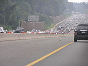
On June 8, 1999, a tractor-trailer carrying a backhoe that exceeded the maximum height requirement struck a pedestrian footbridge over the Baltimore Beltway just northwest of the Interstate 95 junction near Arbutus. The footbridge collapsed onto the inner loop of the Beltway. One driver was killed when his SUV struck the collapsed bridge; six others were injured, three critically. The incident occurred during the afternoon rush hourRush hour
A rush hour or peak hour is a part of the day during which traffic congestion on roads and crowding on public transport is at its highest. Normally, this happens twice a day—once in the morning and once in the evening, the times during when the most people commute...
. The footbridge had been closed to pedestrians since November 1996 due to complaints about vandalism and crime.
McKeldin Beltway
The Beltway was dedicated in honor of former Governor Theodore R. McKeldin in May 2005. McKeldin was responsible for the construction of the Beltway and other state highways during his term. Most Marylanders still refer to the highway as the "Baltimore Beltway," "695," or (mostly among Baltimore metro area residents) simply "The Beltway," like its Washington counterpart.Future
In March 2009, construction began on the reconstruction of the bridge that carries MD 139 (Charles Street) over I-695. The bridge will be decorative, featuring ornamental street lights. As part of the MD 139 project, the interchange will be reconstructed and the traffic circle at the MD 139/I-695 ramps will be removed and replaced with a traffic signal. This project is expected to cost $50 million and be completed in 2012.At Exit 33 (I-95/John F. Kennedy Memorial Highway), both highways cross over themselves so that all through traffic is on the left side of the road with left-hand entrance/exit ramps connecting the crossover sections. This interchange is currently being replaced by a more conventional flyover ramp interchange, as part of the I-95 expansion project under construction since 2007, eliminating the left-turn ramps and double crossovers. So far, several ramps have been completed, with the ramp from northbound I-95 to eastbound I-695 completed in September 2008, the ramp from westbound I-695 to northbound I-95 completed in October 2008, the ramp from northbound I-95 to westbound I-695 completed in November 2008 (eliminating the left-hand exit), and the ramp from eastbound I-695 to southbound I-95 was completed in May 2009. The ramps from southbound I-95 to both westbound and eastbound I-695 were completed in June 2009 and the ramp from westbound I-695 to southbound I-695 was completed in July 2009 and the ramp from eastbound I-695 to northbound I-95 opened in August 2009. In addition to rebuilding these ramps, the project will also add four ramps to service the express toll lanes being added to I-95.
There are long-term plans to add express toll lanes to I-695 to ease traffic congestion along the route. In addition, there are also plans to widen the portion of I-695 between I-83 and I-95 to the north of Baltimore. This road, which is to be widened to eight lanes, is currently in the design phase.
Exit list
Exits are numbered in a clockwiseClockwise
Circular motion can occur in two possible directions. A clockwise motion is one that proceeds in the same direction as a clock's hands: from the top to the right, then down and then to the left, and back to the top...
(inner loop) direction, in accordance with AASHTO guidelines.
{|class=wikitable
!County
!Location
!Mile
!Exit
Exit number
An exit number is a number assigned to a road junction, usually an exit from a freeway. It is usually marked on the same sign as the destinations of the exit, as well as a sign in the gore....
!Destinations
!Notes
|-
|rowspan=10|Anne Arundel
Anne Arundel County, Maryland
Anne Arundel County is a county located in the U.S. state of Maryland. It is named for Anne Arundell , a member of the ancient family of Arundells in Cornwall, England and the wife of Cæcilius Calvert, 2nd Baron Baltimore. Its county seat is Annapolis, which is also the capital of the state...
|rowspan=5|Glen Burnie
Glen Burnie, Maryland
Glen Burnie is a census-designated place in Anne Arundel County, Maryland, United States, and is a suburb of Baltimore. The population was 67,639 at the 2010 census...
|0.00
|colspan=3 align="center"|Curtis Creek Drawbridge over Curtis Creek
Curtis Creek
Curtis Creek is a tidal creek located in Baltimore City and Anne Arundel County, Maryland. It is a tributary of Curtis Bay. The creek begins at the confluence of Furnace Creek and Marley Creek and flows north about to Curtis Bay.-External links:**...
|-
|rowspan=2|0.76
|2
|
|
|-
|colspan=5 align="center"|Maintenance changes from MdTA
Maryland Transportation Authority
The Maryland Transportation Authority is an independent state agency responsible for financing, constructing, operating, and maintaining eight toll facilities, currently consisting of two toll roads, two tunnels, and four bridges in Maryland...
to MDSHA
Maryland State Highway Administration
The Maryland State Highway Administration is the state agency responsible for maintaining Maryland numbered highways outside of Baltimore City...
|-
|1.67
|3A
|
|Access from I-695 east to MD 2 provided by MD 711.
|-
|2.17
|3B
|
|Access from I-695 east to MD 2 south and from MD 2 north to I-695 west provided by I-895B
Interstate 895 (Maryland)
Interstate 895 is an Interstate Highway in the U.S. state of Maryland. Known as the Harbor Tunnel Thruway, the highway runs between one junction with I-95 in Elkridge and another interchange with I-95 on the east side of Baltimore. I-895 is a toll road that crosses the Patapsco River estuary...
.
|-
|Ferndale
Ferndale, Maryland
Ferndale is a census-designated place in Anne Arundel County, Maryland, in the United States. As of the 2000 census, the CDP population was 16,056.-Geography:Ferndale is located at ....
|2.48
|4
|
|
|-
|rowspan=4|Linthicum
Linthicum, Maryland
Linthicum is a census-designated place and an unincorporated community in Anne Arundel County, Maryland, United States. The population was 7,539 at the 2000 census. It is the approximate location of Baltimore-Washington International Thurgood Marshall Airport...
|3.24
|5
|
|
|-
|3.72
|6
|
|Eastbound exit, westbound entrance; split into exits 6A (North Linthicum) and 6B (Linthicum).
|-
|4.54
|7
|, Washington
Washington, D.C.
Washington, D.C., formally the District of Columbia and commonly referred to as Washington, "the District", or simply D.C., is the capital of the United States. On July 16, 1790, the United States Congress approved the creation of a permanent national capital as permitted by the U.S. Constitution....
|Split into exits 7A (Baltimore) and 7B (Washington).
|-
|4.92
|8
|
|Access between I-695 north and MD 168 provided by MD 969A.
|-
|rowspan=44|Baltimore
Baltimore County, Maryland
Baltimore County is a county located in the northern part of the US state of Maryland. In 2010, its population was 805,029. It is part of the Baltimore-Washington Metropolitan Area. Its county seat is Towson. The name of the county was derived from the barony of the Proprietor of the Maryland...
|rowspan=2|Lansdowne
Lansdowne, Maryland
Lansdowne is an unincorporated community in southern Baltimore County, Maryland; just south of Baltimore city. The census combines the communities of Lansdowne and Baltimore Highlands to create the Census-designated Place of Lansdowne-Baltimore Highlands...
|5.61
|8A
|
|Access from I-695 south to I-895 north and from I-895 south to I-695 north.
|-
|5.84
|9
|Hollins Ferry Road – Lansdowne
Lansdowne, Maryland
Lansdowne is an unincorporated community in southern Baltimore County, Maryland; just south of Baltimore city. The census combines the communities of Lansdowne and Baltimore Highlands to create the Census-designated Place of Lansdowne-Baltimore Highlands...
|Former MD 891
|-
|rowspan=3|Arbutus
Arbutus, Maryland
As of the 2010 Census Arbutus had a population of 20,583. The racial and ethnic compositon of the population was 76.6% non-Hispanic white, 9.5% non-Hispanic black, 0.2% Native American, 2.1% Asian Indian, 6.5% other Asian, 0.1% Pacific Islander, 0.2% non-Hispanic from some other race, 2.3% from...
|6.53
|10
|
|The exit from I-695 south to US 1 Alt. splits from exit 11B.
|-
|6.99
|11
|, Washington
Washington, D.C.
Washington, D.C., formally the District of Columbia and commonly referred to as Washington, "the District", or simply D.C., is the capital of the United States. On July 16, 1790, the United States Congress approved the creation of a permanent national capital as permitted by the U.S. Constitution....
|Split into exits 11A (Baltimore) and 11B (Washington).
|-
|7.76
|12A
|
|Inner Loop exit, Outer Loop entrance
|-
|rowspan=4|Catonsville
Catonsville, Maryland
According to the United States Census Bureau, the CDP has a total area of , all of it land.-Demographics:In 2010 Catonsville had a population of 41,567...
|8.72
|12
|
|Split into exits 12B (east) and 12C (west)
|-
|9.96
|13
|
|
|-
|10.44
|14
|Edmondson Avenue
|
|-
|11.19
|15
|
|Split into exits 15A (Baltimore) and 15B (Ellicot City).
|-
|rowspan=2|Woodlawn
Woodlawn, Baltimore County, Maryland
Woodlawn is an unincorporated community and a census-designated place in Baltimore County, Maryland, United States. The population was 36,079 at the 2000 census. It is home to both the headquarters of the Social Security Administration as well as the Centers for Medicare and Medicaid Services...
|12.60
|16
|, Local Traffic
|Split into exits 16A (Local Traffic) and 16B (Frederick).
|-
|13.06
|17
| - Woodlawn
Woodlawn, Baltimore County, Maryland
Woodlawn is an unincorporated community and a census-designated place in Baltimore County, Maryland, United States. The population was 36,079 at the 2000 census. It is home to both the headquarters of the Social Security Administration as well as the Centers for Medicare and Medicaid Services...
|
|-
|Lochearn
Lochearn, Maryland
Lochearn is an unincorporated community and a census-designated place in Baltimore County, Maryland, immediately to the west of Baltimore. The population was 25,269 at the 2000 census.-Description:...
|15.60
|18
|
|Split into exits 18A (Lochearn) and 18B (Randallstown)
|-
|rowspan=4|Pikesville
Pikesville, Maryland
Pikesville is a census-designated place in Baltimore County, Maryland, United States. Pikesville is just northwest of the Baltimore city limits. It is the northwestern suburb closest to Baltimore.The population was 29,123 at the 2000 census...
|17.40
|19
|
|
|-
|18.37
|20
|
|
|-
|19.11
19.60
|21
|
|The two halves of this interchange, at MD 129 and Stevenson Road, are connected by MD 129A
Maryland Route 129
Maryland Route 129 is a state highway in the U.S. state of Maryland, running north-northwesterly from downtown Baltimore into Baltimore County, ending east of Reisterstown...
.
|-
|21.01
|22
|Greenspring Avenue
Greenspring Avenue
Greenspring Avenue is a road in Baltimore, Maryland and its northwestern suburbs. At one time, Greenspring Avenue was Maryland Route 519 from Worthington Road to Dover Road, but the road has since been decommissioned and no longer has any numerical designation....
|-
|rowspan=2|Brooklandville
Brooklandville, Maryland
Brooklandville is an unincorporated community in Baltimore County, Maryland, United States near where the Jones Falls Expressway meets the Baltimore Beltway. The general area is a part of Lutherville, and some addresses in the area are considered to be in Lutherville, though Brooklandville has a...
|rowspan=2|22.74
|23A
|
|West end of concurrency with I-83
|-
|23B
|
|Traffic uses MD 25A
Maryland Route 25
Maryland Route 25 , locally known for nearly its entire length as Falls Road, is a state highway in the U.S. state of Maryland. It begins north of downtown Baltimore, just north of Penn Station, and continues north through Baltimore County almost to the Pennsylvania state line...
between I-695 and MD 25.
|-
|rowspan=2|Lutherville
|24.26
|24
|, York, PA
York, Pennsylvania
York, known as the White Rose City , is a city located in York County, Pennsylvania, United States which is in the South Central region of the state. The population within the city limits was 43,718 at the 2010 census, which was a 7.0% increase from the 2000 count of 40,862...
|East end of concurrency with I-83
|-
|24.88
|25
|
|
|-
|rowspan=5|Towson
Towson, Maryland
Towson is an unincorporated community and a census-designated place in Baltimore County, Maryland, United States. The population was 55,197 at the 2010 census...
|25.90
|26
|
|Split into exits 26A (Towson) and 26B (Lutherville) eastbound; access between I-695 eastbound and MD 45 south provided by MD 45A
Maryland Route 45
Maryland Route 45 is a state highway in the U.S. state of Maryland. Known for most of its length as York Road, the state highway runs from U.S. Route 1 in Baltimore north to the Pennsylvania state line in Maryland Line, where the highway continues as SR 3001...
.
|-
|26.53
|27
|
|Split into exits 27A (Towson) and 27B (north)
|-
|27.78
|28
|Providence Road
|
|-
|28.52
|29A
|Cromwell Bridge Road
|Former MD 567
|-
|28.69
|29B
|
|Exits 29A and 29B are combined on I-695 outer.
|-
|Parkville
Parkville, Maryland
-Demographics:As of the census of 2000, there were 31,118 people, 13,044 households, and 8,243 families residing in the CDP. The population density was 7,352.1 people per square mile . There were 13,550 housing units at an average density of 3,201.4 per square mile...
|29.75
|30
|
|Split into exits 30A (south) and 30B (north)
|-
|Carney
Carney, Maryland
Carney is an unincorporated community and a census-designated place in Baltimore County, Maryland, United States. The population was 28,264 at the 2000 census.-Geography:Carney is located at ....
|30.89
|31
|
|Split into exits 31A (Parkville) and 31B (Carney)
|-
|rowspan=2|Overlea
Overlea, Maryland
Overlea is an unincorporated community and a census-designated place in Baltimore County, Maryland, United States. The population was 12,148 at the 2000 census. Students attend Overlea High School. Area roads include Belair Road and Kenwood Avenue. Contrary to most local residents believe,...
|31.35
|31C
|
|Eastbound exit, westbound entrance
|-
|32.52
|32
|
|Split into exits 32A (Overlea) and 32B (Bel Air)
|-
|Rossville
Rossville, Maryland
Rossville is an unincorporated community and a census-designated place in Baltimore County, Maryland, United States. The population was 11,515 at the 2000 census.-Geography:Rossville is located at ....
|34.07
|33
|
|Split into exits 33A (Baltimore, Washington) and 33B (New York)
|-
|rowspan=2|Rosedale
Rosedale, Maryland
Rosedale is an unincorporated community and a census-designated place in Baltimore County, Maryland, United States. The population was 19,199 at the 2000 census.- History :...
|35.26
|34
|
|
|-
|35.60
|35
|
|Split into exits 35A (Baltimore) and 35B (Aberdeen)
|-
|Essex
Essex, Maryland
-Demographics:As of the census of 2000, there were 39,078 people, 15,952 households, and 10,336 families residing in the CDP. The population density was 4,104.1 people per square mile . There were 16,997 housing units at an average density of 1,785.1 per square mile...
|35.95
|36
|
|
|-
|rowspan=11|Dundalk
Dundalk, Maryland
-Demographics:As of the census of 2000, there were 62,306 people, 24,772 households, and 16,968 families residing in the CDP. The population density was 4,689.5 people per square mile . There were 26,385 housing units at an average density of 1,985.9 per square mile...
|38.73
|38
|
|Split into exits 38A (Baltimore) and 38B (Essex) southbound; no access from northbound I-695 to westbound MD 150 or from eastbound MD 150 to southbound I-695
|-
|39.09
|39
|
|Southbound exit, northbound entrance
|-
|39.35
|rowspan=2|40
|
|Northbound exit, southbound entrance
|-
|40.05
|
|Southbound exit, northbound entrance
|-
|41.08
|41
|
|
|-
|43.56
|42
|
|Southbound exit, northbound entrance
|-
|43.81
|colspan=4 align="center"|Maintenance changes from MDSHA
Maryland State Highway Administration
The Maryland State Highway Administration is the state agency responsible for maintaining Maryland numbered highways outside of Baltimore City...
to MdTA
Maryland Transportation Authority
The Maryland Transportation Authority is an independent state agency responsible for financing, constructing, operating, and maintaining eight toll facilities, currently consisting of two toll roads, two tunnels, and four bridges in Maryland...
at the east end of the bridge over a CSX Transportation
CSX Transportation
CSX Transportation operates a Class I railroad in the United States known as the CSX Railroad. It is the main subsidiary of the CSX Corporation. The company is headquartered in Jacksonville, Florida, and owns approximately 21,000 route miles...
line.
|-
|44.74
|43
|
|
|-
|46.51
|44
|Broening Highway (MD 695A)
|Northbound exit, southbound entrance
|-
|46.92
|colspan=3 align="center"|Key Bridge
Francis Scott Key Bridge (Baltimore)
The Francis Scott Key Bridge, also known as the Outer Harbor Bridge or simply the Key Bridge, is a continuous truss bridge spanning the Patapsco River in Baltimore, Maryland, USA. The main span of is the third longest span of any continuous truss in the world.The bridge was opened in March 1977...
toll plaza
|-
|47.36
|
|
|A U-turn ramp (MD 695), connecting I-695 south to I-695 north. This is used by trucks to Dundalk via exit 44.
|-
|rowspan=2 colspan=2|Baltimore City
|48.23
|colspan=3 align="center"|Key Bridge
Francis Scott Key Bridge (Baltimore)
The Francis Scott Key Bridge, also known as the Outer Harbor Bridge or simply the Key Bridge, is a continuous truss bridge spanning the Patapsco River in Baltimore, Maryland, USA. The main span of is the third longest span of any continuous truss in the world.The bridge was opened in March 1977...
over Patapsco River
Patapsco River
The Patapsco River is a river in central Maryland which flows into Chesapeake Bay. The river's tidal portion forms the harbor for the city of Baltimore...
|-
|50.13
|1
| to Pennington Avenue, Fort Smallwood Road
|
|-
See also
- Interstate 95 in MarylandInterstate 95 in MarylandInterstate 95 in Maryland is a major highway that runs diagonally from northeast to southwest, from Maryland's border with Delaware, to the Woodrow Wilson Bridge, briefly entering the District of Columbia before reaching Virginia...
- Maryland Route 702Maryland Route 702Maryland Route 702 is a state highway in the U.S. state of Maryland. Known as Southeast Boulevard, the state highway runs from Interstate 695 in Rosedale east to Back River Neck Road near Essex. MD 702 is a controlled-access spur that serves Essex in southeastern Baltimore County...
- List of Maryland state highways
- Baltimore Outer BeltwayBaltimore Outer BeltwayThe Baltimore Outer Beltway was a proposed freeway that would encircle parts of the Greater Baltimore area.Parts of it have been built as the following roads:*Maryland Route 100 *US 29 *Maryland Route 43...