

Maryland State Highway Administration
Encyclopedia
The Maryland State Highway Administration (abbreviated MDSHA, MSHA, or simply SHA) is the state agency responsible for maintaining Maryland
numbered highways outside of Baltimore City. Formed in 1908 as the State Roads Commission (SRC), it is tasked with maintaining non-tolled bridges throughout the state, removing snow from the state's major thoroughfares, administering the state's "adopt-a-highway" program, and both developing and maintaining the state's freeway system. It is a division of the Maryland Department of Transportation
and is currently overseen by Neil Pedersen.
The headquarters for MSHA is located in Baltimore City. This building houses numerous divisions and offices, such as:
 MSHA also maintains four research labs located throughout the State, as well as the Office of Traffic and Safety (OOTS) located in Hanover
-- which houses several additional divisions. Some other services provided at the OOTS complex include:
While OOTS and the Districts oversee the installation, modification, operation, maintenance, and removal of traffic signals along State roadways, Montgomery County differs in that it is responsible for the operation and maintenance of all signals within the County—even those along State roadways. However, the Districts and OOTS still controls decisions regarding the installation, modification (including phasing), and removal of signals. A result of this agreement is that it relieves MSHA of some of the additional resource cost of the regular duties with regards to signals.
 There are seven districts in the State. These districts at the least, have divisions for traffic, construction, maintenance, and utilities. Each district also oversees several maintenance shops—typically one per county. The following is a table of the districts, counties within their jurisdiction, and their respective headquarters.
Maryland
Maryland is a U.S. state located in the Mid Atlantic region of the United States, bordering Virginia, West Virginia, and the District of Columbia to its south and west; Pennsylvania to its north; and Delaware to its east...
numbered highways outside of Baltimore City. Formed in 1908 as the State Roads Commission (SRC), it is tasked with maintaining non-tolled bridges throughout the state, removing snow from the state's major thoroughfares, administering the state's "adopt-a-highway" program, and both developing and maintaining the state's freeway system. It is a division of the Maryland Department of Transportation
Maryland Department of Transportation
The Maryland Department of Transportation is a government agency in the U.S. state of Maryland. MDOT is overseen by Transportation Secretary Beverley K. Swaim-Staley, who replaced John Porcari in 2009 upon the latter's appointment as Deputy Secretary of the United States Department of...
and is currently overseen by Neil Pedersen.
The headquarters for MSHA is located in Baltimore City. This building houses numerous divisions and offices, such as:
- Office of Planning and Preliminary Engineering
- Office of Highway Development
- Office of Structures
- Office of Environmental Design
- Office of Construction
- Office of Policy and Research
- Office of Real Estate
- Office of CHART and ITS Development (Note that "CHART" is an acronym for Coordinated Highways Action Response Team and provides incident response services throughout the State, though it only provide regular patrols on interstates and a select few major arterials.)
Hanover, Maryland
Hanover, Maryland is a locality in unincorporated northwestern Anne Arundel County, Maryland in the United States, located south of Baltimore near the Howard County line....
-- which houses several additional divisions. Some other services provided at the OOTS complex include:
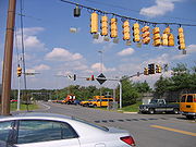
- Traffic Engineering Design Division, which is responsible for the development of new traffic signalsTraffic lightTraffic lights, which may also be known as stoplights, traffic lamps, traffic signals, signal lights, robots or semaphore, are signalling devices positioned at road intersections, pedestrian crossings and other locations to control competing flows of traffic...
, signal modifications, upgrades, and signal phasing. - Office of Maintenance, which provides assistance with recurring maintenance tasks that require more intensive study—particularly roadway safety and resurfacing projects.
- The Statewide Operations Center is responsible for requesting incident response teams for incidents on State roadways. Responders may including police, fire, medical, CHART, HazMat, MEMA, environmental, or maintenance teams. This facility is also equipped to operate as a Statewide Transportation Emergency Operations Center.
- The signal shop, which provides personnel and equipment for the maintenance and programming of signalsTraffic lightTraffic lights, which may also be known as stoplights, traffic lamps, traffic signals, signal lights, robots or semaphore, are signalling devices positioned at road intersections, pedestrian crossings and other locations to control competing flows of traffic...
along State roadways in every county except Montgomery CountyMontgomery County, MarylandMontgomery County is a county in the U.S. state of Maryland, situated just to the north of Washington, D.C., and southwest of the city of Baltimore. It is one of the most affluent counties in the United States, and has the highest percentage of residents over 25 years of age who hold post-graduate...
. - The sign shop, which designs and fabricates signing for use throughout the entire state.
While OOTS and the Districts oversee the installation, modification, operation, maintenance, and removal of traffic signals along State roadways, Montgomery County differs in that it is responsible for the operation and maintenance of all signals within the County—even those along State roadways. However, the Districts and OOTS still controls decisions regarding the installation, modification (including phasing), and removal of signals. A result of this agreement is that it relieves MSHA of some of the additional resource cost of the regular duties with regards to signals.
Districts
| District | Counties | Headquarters |
|---|---|---|
| 1 | Wicomico County Wicomico County, Maryland As of the census of 2010, there were 98,733 people, 37,220 households, and 24,172 families residing in the county. The population density was 261.7 people per square mile . There were 41,192 housing units at an average density of 109.2 per square mile... Worcester County Worcester County, Maryland -2010:Whereas according to the 2010 U.S. Census Bureau:*82.0% White*13.6% Black*0.3% Native American*1.1% Asian*0.0% Native Hawaiian or Pacific Islander*1.7% Two or more races*1.3% Other races*3.2% Hispanic or Latino -2000:... Somerset County Somerset County, Maryland -2010:Whereas according to the 2010 U.S. Census Bureau:*53.5% White*42.3% Black*0.3% Native American*0.7% Asian*0.0% Native Hawaiian or Pacific Islander*1.7% Two or more races*1.5% Other races*3.3% Hispanic or Latino -2000:... Dorchester County Dorchester County, Maryland Dorchester County is a county located in the U.S. state of Maryland on its Eastern Shore. It is bordered by the Choptank River to the north, Talbot County to the northwest, Caroline County to the northeast, Wicomico County to the southeast, Sussex County, Delaware, to the east, and the Chesapeake... |
Salisbury Salisbury, Maryland -Demographics:Salisbury is the principal city of the Salisbury-Ocean Pines CSA, a Combined Statistical Area that includes the Salisbury metropolitan area and the Ocean Pines micropolitan area , which had a combined population of 176,657 at the 2010 census.As of the census of 2000, there were... |
| 2 | Cecil County Cecil County, Maryland Cecil County is a county located in the U.S. state of Maryland. It is part of the Delaware Valley. It was named for Cæcilius Calvert, 2nd Baron Baltimore , who was the first Proprietary Governor of the colony of Maryland from 1632 until his death in 1675. The county seat is Elkton. The newspaper... Kent County Kent County, Maryland Kent County is a county located in the U.S. state of Maryland, on its Eastern Shore. It was named for the county of Kent in England. Its county seat is Chestertown. In 2010, the county population was 20,197... Queen Anne's County Queen Anne's County, Maryland Queen Anne's County is a county located on the Eastern Shore of the U.S. state of Maryland.As of 2010, the population was 47,798. Its county seat and most populous municipality is Centreville. The census-designated place of Stevensville is the county's most populous place... Talbot County Talbot County, Maryland -2010:Whereas according to the 2010 U.S. Census Bureau:*81.4% White*12.8% Black*0.2% Native American*1.2% Asian*0.1% Native Hawaiian or Pacific Islander*1.6% Two or more races*2.7% Other races*5.5% Hispanic or Latino -2000:... Caroline County Caroline County, Maryland Caroline County is a wholly rural county located in the U.S. state of Maryland on its Eastern Shore. It is bordered by Queen Anne's County to the north, Talbot County to the west, Dorchester County to the south, Kent County, Delaware, to the east, and Sussex County, Delaware, to the southeast. As... |
Chestertown Chestertown, Maryland Chestertown is a town in Kent County, Maryland, United States. The population was 4,746 at the 2000 census. It is the county seat of Kent County. The ZIP code is 21620 and the area codes are 410 and 443... |
| 3 | Montgomery County Montgomery County, Maryland Montgomery County is a county in the U.S. state of Maryland, situated just to the north of Washington, D.C., and southwest of the city of Baltimore. It is one of the most affluent counties in the United States, and has the highest percentage of residents over 25 years of age who hold post-graduate... Prince George's County Prince George's County, Maryland Prince George's County is a county located in the U.S. state of Maryland, immediately north, east, and south of Washington, DC. As of 2010, it has a population of 863,420 and is the wealthiest African-American majority county in the nation.... |
Greenbelt Greenbelt, Maryland Greenbelt is a city in Prince George's County, Maryland, United States. Contained within today's City of Greenbelt is the historic planned community now known locally as "Old Greenbelt" and designated as the Greenbelt Historic District... |
| 4 | Baltimore County Baltimore County, Maryland Baltimore County is a county located in the northern part of the US state of Maryland. In 2010, its population was 805,029. It is part of the Baltimore-Washington Metropolitan Area. Its county seat is Towson. The name of the county was derived from the barony of the Proprietor of the Maryland... Harford County Harford County, Maryland Harford County is a county in the U.S. state of Maryland. In 2010, its population was 244,826. Its county seat is Bel Air. Harford County forms part of the Baltimore-Washington Metropolitan Area.-History:... |
Lutherville |
| 5 | Anne Arundel County Anne Arundel County, Maryland Anne Arundel County is a county located in the U.S. state of Maryland. It is named for Anne Arundell , a member of the ancient family of Arundells in Cornwall, England and the wife of Cæcilius Calvert, 2nd Baron Baltimore. Its county seat is Annapolis, which is also the capital of the state... Calvert County Calvert County, Maryland Calvert County is a county located in the U.S. state of Maryland. It occupies the Calvert Peninsula which is bordered on the east by the Chesapeake Bay and on the west by the Patuxent River. Calvert County is part of the Southern Maryland region. Calvert County's residents are among the highest... Charles County Charles County, Maryland Charles County is a county in the south central portion of the U.S. state of Maryland.As of 2010, the population was 146,551. Its county seat is La Plata. This county was named for Charles Calvert , third Baron Baltimore.... Saint Mary's County Saint Mary's County, Maryland Saint Mary's County is a county located in the U.S. state of Maryland.As of 2010, the population was 105,151. Its county seat is Leonardtown... |
Annapolis Annapolis, Maryland Annapolis is the capital of the U.S. state of Maryland, as well as the county seat of Anne Arundel County. It had a population of 38,394 at the 2010 census and is situated on the Chesapeake Bay at the mouth of the Severn River, south of Baltimore and about east of Washington, D.C. Annapolis is... |
| 6 | Washington County Washington County, Maryland Washington County is a county located in the western part of the U.S. state of Maryland, bordering southern Pennsylvania to the north, northern Virginia to the south, and the Eastern Panhandle of West Virginia to the south and west. As of the 2010 Census, its population is 147,430... Allegany County Allegany County, Maryland Allegany County is a county located in the northwestern part of the US state of Maryland. It is part of the Cumberland, MD-WV Metropolitan Statistical Area. As of 2010, the population was 75,087. Its county seat is Cumberland... Garrett County Garrett County, Maryland Garrett County is the westernmost county of the U.S. state of Maryland. Created from Allegany County, Maryland in 1872 it was the last Maryland county to be formed. It was named for John Work Garrett , railroad executive, industrialist, and financier. Garrett served as president of the Baltimore... |
La Vale La Vale, Maryland La Vale is a census-designated place in Allegany County, Maryland, United States. It is part of the 'Cumberland, MD-WV Metropolitan Statistical Area'... |
| 7 | Frederick County Frederick County, Maryland Frederick County is a county located in the western part of the U.S. state of Maryland, bordering the southern border of Pennsylvania and the northeastern border of Virginia. As of the 2010 Census, the population was 233,385.... Howard County Howard County, Maryland -2010:Whereas according to the 2010 U.S. Census Bureau:*62.2% White*17.5% Black*0.3% Native American*14.4% Asian*0.0% Native Hawaiian or Pacific Islander*3.6% Two or more races*2.0% Other races*5.8% Hispanic or Latino -2000:... Carroll County Carroll County, Maryland Carroll County is a county located in the U.S. state of Maryland. In 2010, its population was 167,134. It was named for Charles Carroll of Carrollton , signer of the American Declaration of Independence. Its county seat is Westminster.... |
Frederick Frederick, Maryland Frederick is a city in north-central Maryland. It is the county seat of Frederick County, the largest county by area in the state of Maryland. Frederick is an outlying community of the Washington-Arlington-Alexandria, DC-VA-MD-WV Metropolitan Statistical Area, which is part of a greater... |