
Organ Pipes National Park
Encyclopedia
Protected area
Protected areas are locations which receive protection because of their recognised natural, ecological and/or cultural values. There are several kinds of protected areas, which vary by level of protection depending on the enabling laws of each country or the regulations of the international...
, is located in Victoria
Victoria (Australia)
Victoria is the second most populous state in Australia. Geographically the smallest mainland state, Victoria is bordered by New South Wales, South Australia, and Tasmania on Boundary Islet to the north, west and south respectively....
, Australia
Australia
Australia , officially the Commonwealth of Australia, is a country in the Southern Hemisphere comprising the mainland of the Australian continent, the island of Tasmania, and numerous smaller islands in the Indian and Pacific Oceans. It is the world's sixth-largest country by total area...
. It was established with the focus on conservation of the native flora and fauna, and preservation of the geological features in the Jackson Creek, a part of the Maribyrnong valley, north-west of Melbourne. It is situated in a deep gorge in the barren Keilor plains.
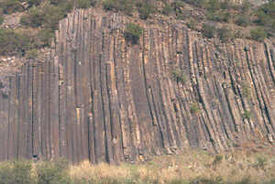
Within the park, there are 400 million year old volcanic geological formations, most notable the hexagonal basalt columns known as the "Organ Pipes". These are set in a vertically standing formation, in layers, as if thickly welded together. This trap rock
Trap rock
Trap rock is a form of igneous rock that tends to form polygonal vertical fractures, most typically hexagonal, but also four to eight sided. The fracture pattern forms when magma of suitable chemical composition intrudes as a sill or extrudes as a thick lava flow, and slowly cools.Because of the...
formation emerged as the result of slow cutting of a deep valley in the basaltic plains over several centuries by the Maribyrnong River
Maribyrnong river
The Maribyrnong River rises about 50 km north of Melbourne, Victoria , near Mount Macedon. It flows generally southward and combines with the Yarra River to flow into Port Phillip....
. Study of the fossils in volcanic rock formations have been inferred as sedimentary rocks that got buried under the sea about 400 million years ago.
A Friends’ group, the "Friends of Organ Pipes" (FOOPS), comprising conservation activists to support the efforts of rehabilitation of the OPNP’s indigenous flora and fauna, supplemented the work of the Victoria Park system under which the OPNP was declared a National Park. The park's importance to the whole region as a "center for education about the geology, flora and fauna of the Keilor Plains, and the restoration of degraded land" is important. With its inclusion in the IUCN Category III (Natural Monuments) of the United Nations’ list of National Parks and Protected Areas, there is a greater recognition of the need to protect or preserve outstanding natural features.
Geography
The national park, designated to cover an area of 121 hectares (299 acre), is situated 20 hectares (49.4 acre) to the northwest of Melbourne city. It is part of the Victoria Park system. It is approachable from the Calder HighwayCalder Highway
Calder Highway is a Highway linking Ravenswood South in Victoria, to Mildura. North of the Victoria/New South Wales border, the highway continues north to Broken Hill, Tibooburra and the New South Wales/Queensland border as the Silver City Highway, under the standard national route shield as far...
. The Jacksons Creek, which is at the heart of the park, is bounded by the city of Hume on the northern side while the city of Brimbank
City of Brimbank
The City of Brimbank is a Local Government Area located within the metropolitan area of Melbourne, Victoria, Australia. It comprises the western suburbs between 10 and 20 km west and northwest from the Melbourne city centre.It has an area of 123 km²...
is to its south; Deep Creek and Keilor Plains to the west of Melbourne are also part of this geographical setting. The complementary areas to the park are the Holden Flora Reserve (65 hectares (160.6 acre)), Holden School Site (25 hectares (61.8 acre)), Derrimut Grassland Reserve ( 154 hectares (380.5 acre)) and Laverton and North Grassland Reserve (52 hectares (128.5 acre)).
OPBNP is located just off the M79 Calder Freeway
Calder Freeway
Calder Freeway is a freeway linking Melbourne to Ravenswood South in Victoria, Australia, superseding stretches of the Calder Highway. Originally just a short spur of the Tullamarine Freeway linking to the Calder Highway in Keilor in suburban Melbourne, it has been extended in phases to Ravenswood...
(Melway
Melway
Melway is an almost ubiquitous street directory for Melbourne, Australia and its immediate surrounds, including the city of Geelong. It is currently in its 39th edition—the 2012 edition—which was released in July 2011.-History:Melway was conceived by Merv Godfrey and Iven Mackay in the 1950s...
map 3, grid position D3). The road network around the park consists of the Calder Highway on the south and the Calder Raceway
Calder Park Raceway
Calder Park Raceway is a motor racing circuit in Melbourne, Victoria, Australia. The complex includes a drag strip, a road circuit with several possible configurations, and the "Thunderdome", a high-speed banked oval equipped to race either clockwise or counter-clockwise .-History:Calder Park...
also on the southern direction but close to its entrance.
Out of the total area of 121 hectares (299 acre), the conservation area is 107.3 hectares (265.1 acre) (88.6%), conservation and recreation area is 13 hectares (32.1 acre) (10.8%), visitor center accounts for 0.7 hectares (1.7 acre) (0.6%), and 2 hectares (4.9 acre) (1.6%) is the special management area.
The park is drained by Jackson Creek, Deep Creek and Emu Creek. These are the major tributaries of the Maribyrnong River, which has a catchment area of 1300 square kilometres (501.9 sq mi). Jackson Creek rises in the Wombat State Forest
Wombat State Forest
The Wombat State Forest is located west of Melbourne, Victoria, Australia, between Woodend and Daylesford, at the Great Dividing Range. The forest is approximately in size and sits upon Ordovician or Tertiary sediments...
, flows east to the Roslynn Reservoir, joining Deep Creek near Sydenham Park. It outflows from the reservoir through Gisborne, Sunbury before flowing through Organ Pipes National Park.
Climate
The park lies in a rain shadow area. According to records maintained at the Melbourne Airport since 1972, the average annual rainfall in the park area is 580 millimetres (22.8 in) (occurs during winter and spring). Occasionally, heavy rainfall occurs in the area and one such event caused heavy floods during winter in the flood plains of Maribyrnong, in September 1993, causing loss of vegetation, destroying the viewing platform and also scouring the banks of the creek.Early period
The earliest settlers in the plains of the park area and its vicinity were the aboriginal people known as the WoiworungWurundjeri
The Wurundjeri are a people of the Indigenous Australian nation of the Woiwurrung language group, in the Kulin alliance, who occupy the Birrarung Valley, its tributaries and the present location of Melbourne, Australia...
tribe of the Kulin
Kulin
The Kulin nation, was an alliance of five Indigenous Australian nations in Central Victoria, Australia, prior to European settlement. Their collective territory extended to around Port Phillip and Western Port, up into the Great Dividing Range and the Loddon and Goulburn River valleys. To their...
nation in the Yarra
Yarra River
The Yarra River, originally Birrarung, is a river in east-central Victoria, Australia. The lower stretches of the river is where the city of Melbourne was established in 1835 and today Greater Melbourne dominates and influences the landscape of its lower reaches...
and Maribyrnong River valleys. Jackson Creek formed part of the boundary between two clan estates, Marin-Bulluk and Wurundjeri-Willam. There were hunter gatherers who lived on the forest products and thus subjected the area to some degree of ecological pressure causing degradation of the environment. During this period, Themeda grass species and spear grass (Stipa
Stipa
This article is about a type of grass.For Speech Transmission Index for Public Address Systems, see Speech transmission index.For the Italian aircraft designer, see Luigi Stipa...
spp.) were grown and regrown in the area of the Keilor Plains after burning every year; the climate and rainfall also favoured growth of native grasses in the rolling plains. Animal species such as kangaroos, dingoes, tiger, bandicoots, gliders and platypuses were common. Bird species of cockatoos, kookaburras, quails, finches and hawks also flourished. The vegetation was also lush with grass lands and plenty of plants with flowering blooms. Their habitation of the area is established by archaeological findings in the area in the form of their campsites and isolated artefacts within the park. The environment along Jackson Creek environment facilitated shelter, water and plentiful food for their original settlement.
European settlers’ period
In early 19th century, Europeans from TasmaniaTasmania
Tasmania is an Australian island and state. It is south of the continent, separated by Bass Strait. The state includes the island of Tasmania—the 26th largest island in the world—and the surrounding islands. The state has a population of 507,626 , of whom almost half reside in the greater Hobart...
started settling in the area. They were chiefly responsible for introducing several species of exotic plants and animals into the area as they found the terrain to be drab and filled with strange animals like kangaroo. They introduced new variety of plants such as boxthorn
Boxthorn
Boxthorn is a genus of the nightshade family , containing about 90 species of plants native throughout much of the temperate and subtropical zones of the world...
hedges for fences and trees such as oaks, willows and pine, creating an ambiance of their homeland. Kangaroos were hunted, rabbits and furred animals were killed for their valuable skin. This had ill effects on the native vegetation and faunal species. So much so that “high artichoke thistles blanketed the creek flats and slopes, horehound had spread everywhere, boxthorn bushes crowded the slopes and plains, and other weed species filled the gaps. Erosion gullies scarred the steep slopes. Rubbish was piled here and there”.
During this period, there was a hamlet near the Organ Pipes and a suspension bridge across Jacksons Creek to reach a school and farm lands that surrounded the village. The Hall family lived here between 1870 and the 1920s; their plum tree orchards still exist. The European settlers’ period is also borne out by archaeological artefacts in the form of bluestone walls. The stables in the park area were built by the Halls in which the Hayes family lived, and a Jackson Bay fig tree is located near the Information Center. The Bartlett family lived here from 1934 to 1948 and the last owner was E. A. Green. His estate became the property of the Crown and the trust of E. A. Green Charitable Foundation which was eventually donated to the Organ Pipes National Park in 1972.
National Park period
Consequent to the deterioration of the environmental conditions, the well-meaning, environmentally conscious citizens decided to rehabilitate the environment by reinvigorating the area. The first step towards this end was initiated by the National Park Service in 1972 by declaring initially an area of 65 hectares (160.6 acre) of the land donated by the E. A. Green Charitable Foundation as a national park. Under Schedule 2 of The National Parks Act 1971 (Vic.), the area was declared as National Park on 12 March 1972. There were several objectives of this declaration, but the intent was to restore the park with both direct and indirect interventions to improve the ecosystem. Direct intervention came in the form of planting indigenous species as seedlings, and indirect format was to de-weed the area. As a result, the overstorey plants of indigenous variety and understorey species are now well established.An area of 20 hectares (49.4 acre) of land was added under the National Parks (Amendment) Act 1978 (Vic.) and another 36 hectares (89 acre) of Crown land (including land acquired previously forcibly for the Park) was added on 4 June 1997. The National Parks Act enjoins on the Director of the park “to preserve and protect the natural environment of the Park, and its natural and other features.” It also stipulates the use of the park by the public for enjoyment, recreation and education, apart from the needed research. The Park Regulations 1992 Section 4 (Objects) is related to visitor activities and Section 17 of the National Parks Act governs the management of the Park. The Park is also reserved as a “Geological Monument” under the final recommendations for the Melbourne Study Area (LCC 1977) and also continues as a National Park for the Melbourne Area District 1 Review (LCC 1987). Fire Protection Plan, Port Phillip Area (former Melbourne Region) (CNR 1996); Draft Conservation Program for Native Grasslands and Grassy Woodlands in Victoria (CNR 1992) and Code of Practice for Fire Management on Public Land (CNR 1995) are some of the other legalese connected with the park.
The particular site was chosen because of the presence of several interesting geological features, including the "Organ Pipes", themselves a pattern of vertical pipe-like rock structures exposed by the erosion of the creek, and a "tesselated pavement", where the rock surface has been split into regular "tiles".
Geological formations
The Keilor Plains, where the geomorphologicalGeomorphology
Geomorphology is the scientific study of landforms and the processes that shape them...
and geological
Geology
Geology is the science comprising the study of solid Earth, the rocks of which it is composed, and the processes by which it evolves. Geology gives insight into the history of the Earth, as it provides the primary evidence for plate tectonics, the evolutionary history of life, and past climates...
features of heritage value are located, is part of the greater Western Volcanic Plains which cover a large part of western Victoria and extend into south-eastern South Australia
South Australia
South Australia is a state of Australia in the southern central part of the country. It covers some of the most arid parts of the continent; with a total land area of , it is the fourth largest of Australia's six states and two territories.South Australia shares borders with all of the mainland...
and are stated to be the third largest lava plains in the world . The evolution of these formations is attributed to incision of the Jacksons Creek created by successive lava flows about "more than one million years ago (Upper Tertiary
Tertiary
The Tertiary is a deprecated term for a geologic period 65 million to 2.6 million years ago. The Tertiary covered the time span between the superseded Secondary period and the Quaternary...
), overlying steeply dipping Ordovician
Ordovician
The Ordovician is a geologic period and system, the second of six of the Paleozoic Era, and covers the time between 488.3±1.7 to 443.7±1.5 million years ago . It follows the Cambrian Period and is followed by the Silurian Period...
to Silurian
Silurian
The Silurian is a geologic period and system that extends from the end of the Ordovician Period, about 443.7 ± 1.5 Mya , to the beginning of the Devonian Period, about 416.0 ± 2.8 Mya . As with other geologic periods, the rock beds that define the period's start and end are well identified, but the...
sedimentary rocks".
Sedimentary rock and fossil
Fossil
Fossils are the preserved remains or traces of animals , plants, and other organisms from the remote past...
s found in the park are also dated back 400 million years, an indication that the area was once a sea. The rocks seen in the park have mostly dark grey or brown colour. Graptolites are seen as fossils of sea snails, sea worms and extinct floating animals in the rocks here. About one million years ago giant lava
Lava
Lava refers both to molten rock expelled by a volcano during an eruption and the resulting rock after solidification and cooling. This molten rock is formed in the interior of some planets, including Earth, and some of their satellites. When first erupted from a volcanic vent, lava is a liquid at...
flows known as a flood basalt
Flood basalt
A flood basalt or trap basalt is the result of a giant volcanic eruption or series of eruptions that coats large stretches of land or the ocean floor with basalt lava. Flood basalts have occurred on continental scales in prehistory, creating great plateaus and mountain ranges...
spread across the land from surrounding volcano
Volcano
2. Bedrock3. Conduit 4. Base5. Sill6. Dike7. Layers of ash emitted by the volcano8. Flank| 9. Layers of lava emitted by the volcano10. Throat11. Parasitic cone12. Lava flow13. Vent14. Crater15...
es.
Rock exposures of the "Silurian mud stones" and jointed structural features of basalt are spread at many locations in the form of Basalt cliffs, boulder screes and sedimentary escarpments. The geological features in the Park, all of volcanic origin, have been categorized under the broad heads namely, the Organ Pipes, Tessellated Pavement, Rosette Rock, Scoria cone and the Sandstone layer.
Organ Pipes
Jackson Creek, which meets with Deep Creek to become the Maribyrnong RiverMaribyrnong river
The Maribyrnong River rises about 50 km north of Melbourne, Victoria , near Mount Macedon. It flows generally southward and combines with the Yarra River to flow into Port Phillip....
, has slowly worn a deep valley in the basaltic plain formation of hard, dark rock revealing the old volcanic geological formations such as the hexagonal basalt columns known as the "Organ Pipes"; the lava deposit in the bed of the creek is of the order of 70 metres (229.7 ft). As the lava cooled over several years the interior molten lava got insulated and developed into undisturbed columns of basalt (with uniform composition) as the lava heat dissipated. The cooling effect caused shrinkage and as scientifically elaborated:
- "This shrinkage caused tension in the rock mass. Vertical (upward and downward) tension could be accommodated by the elastic molten rock beneath but horizontal tension could not be relieved and so the basalt cracked. The rock usually cracks in a hexagonal pattern (six sides), but columns with up to eight sides are found. The rock was still hot (about 400 °C (752 °F)) when the columns were formed. Further contraction took place as the rock lost its remaining heat; this was relieved by horizontal cracking, causing some columns to look like stacks of Dutch cheese."
As seen now, the rock formation rises to a height of 20 metres (65.6 ft) and is considered as the best example of columnar jointing in Victoria.
The unusual shape of Jackson Creek Organ Pipes is attributed to the columnar structure which is rare and occurred at strategic location where the down cutting action of the stream created the post-volcanic valley. The Organ Pipes is so named as it resembles a pipe organ. The width of each pipe in the formation is about 1 metres (3.3 ft); only some of the columns are vertical while most other smaller columns around the Pipes are either inclined or horizontal.
Tessellated pavement
Tessellated pavement is an assortment of basalt columns that evolved as a result of erosion by the Jackson Creek, which is seen in the form of pavements about 250 m upstream of the Rosette Rock. Frequent access to this formation is likely to cause deterioration of this formation.Rosette rock
Rosette rock is a radial array of basalt columns. Rosette rock formation seen about 500 metres (1,640.4 ft) upstream of the Organ Pipes is an overhanging rock on the northern bank of the stream. It is also an outcrop of basalt but with a radial array of columns akin to the spokes of a giant wheel. Its formation is attributed to the cooling of "a pocket of lava, probably in a spherical cave formed from an earlier lava flow".Scoria cone
Scoria cone seen near the car park at the park entrance is a remnant of a weathered formation in the form of a cone. The car park is inferred as located on the remains of the weathered scoria cone. The explanation for this phenomenon is that; "at about the same time as the larger volcanoes to the north were producing lava (800,000 to a million years ago). This cone ejected molten rock in a series of explosions producing scoria. Scoria is brownish in colour and is filled with air-pockets."Sandstone layer
The sandstone layer seen in the Jackson Creek has been dated to about 400 million years old. They are made of quartzQuartz
Quartz is the second-most-abundant mineral in the Earth's continental crust, after feldspar. It is made up of a continuous framework of SiO4 silicon–oxygen tetrahedra, with each oxygen being shared between two tetrahedra, giving an overall formula SiO2. There are many different varieties of quartz,...
and quartzite
Quartzite
Quartzite is a hard metamorphic rock which was originally sandstone. Sandstone is converted into quartzite through heating and pressure usually related to tectonic compression within orogenic belts. Pure quartzite is usually white to gray, though quartzites often occur in various shades of pink...
gravel, and are located midway between the car park and the Organ Pipes. They are stated to be part of a deep lead – an ancient stream bed buried by a lava flow, and later revealed by the downcutting of Jackson Creek. Deep leads were mined for gold
Gold
Gold is a chemical element with the symbol Au and an atomic number of 79. Gold is a dense, soft, shiny, malleable and ductile metal. Pure gold has a bright yellow color and luster traditionally considered attractive, which it maintains without oxidizing in air or water. Chemically, gold is a...
in Ballarat during the Gold Rush
Gold rush
A gold rush is a period of feverish migration of workers to an area that has had a dramatic discovery of gold. Major gold rushes took place in the 19th century in Australia, Brazil, Canada, South Africa, and the United States, while smaller gold rushes took place elsewhere.In the 19th and early...
es."
Soils
The volcanic soils in the park formed above basaltic rock base are found in the valleys and have gentle or flat slopes. Soil types have been classified as zonal types comprising red-brown earths (dominant type in the park with low permeability), grey duplex soils in flat areas (with high permeability) and uniform medium loams (on steep slopes on the southern direction of shallow depth and well drained); azonal soil types consisting of alluvial soils (fertile soils in the park consisting of clayClay
Clay is a general term including many combinations of one or more clay minerals with traces of metal oxides and organic matter. Geologic clay deposits are mostly composed of phyllosilicate minerals containing variable amounts of water trapped in the mineral structure.- Formation :Clay minerals...
loam
Loam
Loam is soil composed of sand, silt, and clay in relatively even concentration . Loam soils generally contain more nutrients and humus than sandy soils, have better infiltration and drainage than silty soils, and are easier to till than clay soils...
s to gravels suitable to grow tolerant plant species like river red gum
River Red Gum
The River Red Gum is a tree of the genus Eucalyptus. It is one of around 800 in the genus. It is a plantation species in many parts of the world, but is native to Australia, where it is widespread, especially beside inland water courses...
and river bottle-brush), colluvial soils (at the toe of steep slopes of dark grey to dark brown in colour, suitable to grow wide variety of vegetation) and lithosols (reddish brown soils on steep slopes and frequently support boxthorn and indigenous lightwoods (Acacia implexa
Acacia implexa
Acacia implexa is an Australian Acacia, used for furniture making. Its common name is Lightwood....
); and other lithosols which are pre-basaltic sands and gravels seen near the foot of Grey Box Gully and in lower slopes of the Jacksons Creek valley.
Soils in the park have been subject to erosion, weed growth, human activity and animal burrowing, particularly by rabbits. They are generally found not suitable for plant growth due to their poor water holding property. The degradation of the soils has been arrested with extensive re vegetation.
Flora
Intense propagation of vegetation of native species, in an otherwise plain degraded area infested with weeds (semblance of native vegetation seen mainly as thistles and boxthorns), started from the time of declaring the area as a national park in 1972. Work continued to remove introduced plants and vermin, and reintroduce natural vegetation and wildlife to the park. As of 2002, large areas of trees and shrubbery began to be re-established, systematic planting of native grass, plants and trees was started, which has created large swathes of Kangaroo Grass (themeda triandraThemeda triandra
Themeda triandra is a perennial grass widespread in Africa, Australia, Asia and the Pacific. In Australia it is commonly known as kangaroo grass, in East and South Africa it is known as "red oat grass" or red grass, in Afrikaans, rooigras.The species has a tuffted habit and can reach up to 1.5 m...
). The effect of the re vegetation project in progress for now more than two decades has created a variety of ecosystems. Seven types of wattle
Wattle
Wattle may refer to:*Wattle , a fleshy growth hanging from the head or neck of certain animals.*Wattle is another term for Congenital cartilaginous rest of the neck...
were seen blooming at one time and many other indigenous plants.
Six types of vegetation witnessed, consequent to the re-vegetation programme launched by the Park Administration with assistance from FOOPS, are in three landform zones reflecting the soils derived from the underlying geology. These landforms are the plains and the escarpment. The overall picture of floral abundance that has emerged after the area was declared a national park is identification of 124 indigenous plant species including over 20 species which are in the category of rare or threatened or significant. Some of the significantly recreated basalt plain grassland plants are: Chloris truncate (Windmill Grass- native species), Bothriochloa macra (or Redleg Grass which are red or purplish colour that grow in late summer), Danthonia
Danthonia
Danthonia is a genus of grass species. Grasses of this genus are sometimes referred to as oatgrass, but that common name is not restricted to this genus.Species include:*Danthonia alpina Vest*Danthonia cachemyriana Jaub. & Spach...
species or Wallaby grasses (important native pasture grasses), Dicanthium sericeum (Silky or Queensland
Queensland
Queensland is a state of Australia, occupying the north-eastern section of the mainland continent. It is bordered by the Northern Territory, South Australia and New South Wales to the west, south-west and south respectively. To the east, Queensland is bordered by the Coral Sea and Pacific Ocean...
Bluegrass
Poa
Poa is a genus of about 500 species of grasses, native to the temperate regions of both hemispheres. Common names include meadow-grass , bluegrass , tussock , and speargrass. "Poa" is Greek for fodder...
), Themeda triandra
Themeda triandra
Themeda triandra is a perennial grass widespread in Africa, Australia, Asia and the Pacific. In Australia it is commonly known as kangaroo grass, in East and South Africa it is known as "red oat grass" or red grass, in Afrikaans, rooigras.The species has a tuffted habit and can reach up to 1.5 m...
(Kangaroo Grass, a high protein grass), Rutidosis leptorrhynchoides
Rutidosis leptorrhynchoides
The Button Wrinklewort is a flowering plant of the genus Rutidosis in the daisy family . Its natural distribution is south eastern Australia where its restricted to undisturbed grasslands and woodlands...
(Button Wrinklewort - an endangered species) and Callitris glaucophylla (Murray Pine).
On the banks of the valley formed by Jacksons Creek, there are some stray indigenous plant varieties; these are the River
Red Gum
Red Gum
Red Gum may refer to any of a number of species of Eucalyptus or the closely related Corymbia, including*Corymbia calophylla, Red Gum or Marri, native to Western Australia*Eucalyptus camaldulensis, Red Gum, Murray Red Gum or River Red Gum...
riparian woodland (also Manna Gum
Manna Gum
Eucalyptus viminalis, Manna Gum, also known as White Gum, Ribbon Gum or Viminalis is an Australian eucalypt.It is a straight erect tree, often around 40 metres tall, with rough bark on the trunk and base of larger branches, its upper bark peels away in long "ribbons" which can collect on the...
and Blackwood
Australian Blackwood
Acacia melanoxylon, commonly known as the Australian Blackwood, is an Acacia species native in eastern Australia. The species is also known as Sally Wattle, Lightwood, Hickory, Mudgerabah, Tasmanian Blackwood or Black Wattle . This tree species grows fast and tall, up to 45 m height...
species), Reed bed and Sedgeland species and also shrub land and grasslands. White
White
White is a color, the perception of which is evoked by light that stimulates all three types of color sensitive cone cells in the human eye in nearly equal amounts and with high brightness compared to the surroundings. A white visual stimulation will be void of hue and grayness.White light can be...
Cypress-pine
Cypress-pine
Cypress-pine is the common name used for three closely related genera of conifers in the cypress family Cupressaceae:*Callitris *Actinostrobus *Widdringtonia...
, one of the two recorded in Melbourne is also seen in this valley. Silky Blue Grass and Red-leg Grass are also noted in the park area adjoining the Sydenham Park.
The impact of the natural vegetation growth, however, is the loss of visibility of the geological formations.
Fauna
The diverse faunal significance of the OPNP is evident in the riparian, escarpment and grassland environments in the park. The faunal species found in the OPNP range from birds, mammals (such as Eastern Grey KangarooEastern Grey Kangaroo
The Eastern Grey Kangaroo is a marsupial found in southern and eastern Australia, with a population of several million. It is also known as the Great Grey Kangaroo and the Forester Kangaroo...
, Swamp Wallaby
Swamp Wallaby
The Swamp Wallaby is a small macropod marsupial of eastern Australia. This wallaby is also commonly known as the Black Wallaby, with other names including Black-tailed Wallaby, Fern Wallaby, Black Pademelon, Stinker , and Black Stinker...
), reptiles (including Long-necked Tortoise, the Eastern Bearded Dragon
Eastern Bearded Dragon
The Eastern bearded dragon is an agamid lizard found in wooded parts of Australia. It is one of a group of species known commonly as Bearded Dragons...
, and the Red-bellied Black Snake
Red-bellied Black Snake
The Red-bellied Black Snake, Pseudechis porphyriacus, is a species of elapid snake native to eastern Australia. Though its venom is capable of causing significant morbidity, it is not generally fatal and less venomous than other deadly Australian snakes. It is common in woodlands, forests and...
), and echidnas. With the park’s programme of intensive induction of native vegetation in the area, several faunal species also started to proliferate. A 1988 mammal survey conducted at OPNP by the Arthur Rylah Institute for Environmental Research
Arthur Rylah Institute for Environmental Research
The Arthur Rylah Institute for Environmental Research is the biodiversity research organisation for the Department of Sustainability and Environment of the government of Victoria, Australia. It provides advice on ecologically sustainable land and water management issues and with regard to...
found bats to be the most diverse group of native mammals in occurrence. A very successful bat roosting box project has been underway for 20 years. Avifaunal species (such as the Wedge-tailed Eagle
Wedge-tailed Eagle
The Wedge-tailed Eagle , sometimes known as the Eaglehawk in its native range, is the largest bird of prey in Australia, but it is also found in southern New Guinea. It has long, fairly broad wings, fully feathered legs, and an unmistakable wedge-shaped tail...
) are proliferating. Growling Grass Frog
Growling Grass Frog
The Growling Grass Frog , also commonly known as the Southern Bell Frog, Warty Swamp Frog and erroneously as the Green Frog is a species of ground dwelling tree frog is native to South eastern Australia; ranging from southern South Australia along the Murray River though Victoria to New South...
, and many indigenous fish species (such as the Mountain galaxias
Mountain galaxias
The mountain galaxias species complex is a group of freshwater Galaxiid fish found all over southeast Australia. They form a cryptic species complex.-Classification:These fish were originally designated as a single species, Galaxias olidus, despite:...
) have also reappeared. The Sugar glider
Sugar Glider
The sugar glider is a small gliding possum originating from the marsupial family.The sugar glider is native to eastern and northern mainland Australia and is also native to New Guinea and the Bismarck Archipelago.- Habitat :Sugar gliders can be found all throughout the northern and eastern parts of...
(Petaurus breviceps) which was previously in the OPNP in 1916 was relocated into the park in 1989 from Toolern Vale
Toolern Vale, Victoria
Toolern Vale is a town in Victoria, Australia, 39 km north-west from Melbourne's central business district. Its Local Government Area is the Shire of Melton...
. This is one of many projects run by the Friends of the Organ Pipes National Park. Overall, OPNP authorities have reported 15 mammal native species, 88 species of avifauna, 13 reptile species and 6 amphibian species.
Management plan
A Management Plan was approved by the Conservation and Management of Parks, Victoria under Section 17 of the National Parks Act 1975 (Vic.), in 1996, with the objective of conserving nature and to provide exposure to the public at large to the natural and cultural heritages of the national parks as also promote tourism. For this purpose, the park has been divided into management zones to provide a geographical context to manage the park, appropriate actions to be taken to meet the specific requirements of the zones, avoid any conflicting actions and review the progress achieved from time to time. Some of the set management actions taken over the years to bring in a change from a degraded ecosystem to a near natural ecosystem are: Weed control through mechanical and chemical methods with occasional use of fire; removal of noxious weeds, vermin control, check on growth of rabbits, and rehabilitation of degraded land through a major re-vegetation programme with erosion control, maintaining seed banks and nurseries.An Information Center, maintained by the Park Administration in the park precincts, disseminates information on the volcanic formations in the park, aboriginals who lived in the area, about early European settlements, the re-vegetation project of the once degraded park and its role among national parks in conservation and preservation of the ecology of the area.
Attractions
The park is also a popular tourist destination as it houses the Organ Pipes, The Tessellated Pavement, the Rosette Rock and much more. There is a Visitors Center and picnic area next to the car park and short walking tracks down a rather steep hill to Jacksons Creek and the rock features.The park is under the flight path of Melbourne Airport
Melbourne Airport
Melbourne Airport , also known as Tullamarine Airport, is the primary airport serving the city of Melbourne and the second busiest in Australia. It was opened in 1970 to replace the nearby Essendon Airport. Melbourne Airport is the sole international airport of the four airports serving the...
and adjacent to the Calder Park Raceway
Calder Park Raceway
Calder Park Raceway is a motor racing circuit in Melbourne, Victoria, Australia. The complex includes a drag strip, a road circuit with several possible configurations, and the "Thunderdome", a high-speed banked oval equipped to race either clockwise or counter-clockwise .-History:Calder Park...
so aircraft and/or motor sport noise can be a feature of a visit. The birds and other animals seem to be unaffected by this and an early morning or dusk visit will be rewarded by sightings of Swamp Wallabies
Swamp Wallaby
The Swamp Wallaby is a small macropod marsupial of eastern Australia. This wallaby is also commonly known as the Black Wallaby, with other names including Black-tailed Wallaby, Fern Wallaby, Black Pademelon, Stinker , and Black Stinker...
and Eastern Grey Kangaroo
Eastern Grey Kangaroo
The Eastern Grey Kangaroo is a marsupial found in southern and eastern Australia, with a population of several million. It is also known as the Great Grey Kangaroo and the Forester Kangaroo...
s.
See also
- Giant's CausewayGiant's CausewayThe Giant's Causeway is an area of about 40,000 interlocking basalt columns, the result of an ancient volcanic eruption. It is located in County Antrim on the northeast coast of Northern Ireland, about three miles northeast of the town of Bushmills...
, a much smaller and similar formation in Northern Ireland - Protected areas of Victoria (Australia)Protected areas of Victoria (Australia)Victoria is the smallest mainland state in Australia. It contains 1966 separate Protected Areas with a total land area of 33,780 km² . Of these, 36 are National parks, totalling 25,774 km² ....