
Macquarie Fields, New South Wales
Encyclopedia
Macquarie Fields is a suburb
of Sydney
, in the state of New South Wales
, Australia
. Macquarie Fields is located 42 kilometres south-west of the Sydney central business district
, in the local government area of the City of Campbelltown and is part of the Macarthur
region.
Macquarie Fields has a mix of public and private housing and is surrounded by bushland
. Nearby Macquarie Links
, is a high-security housing estate based around an international standard golf course
.
of western Sydney. The rich soil of the area was home to an abundance of plants which in turn attracted animals such as kangaroo
s and emu
s, both of which along with yam
s and other native vegetables and fruit were part of the diet of the Darug. They lived in small huts called gunyahs, made spears, tomahawks and boomerang
s for hunting and had an elaborate system of tribal law and rituals with its origins in the Dreamtime
. However, following the arrival of the First Fleet
in 1788, they were pushed off their land by the British settlers.
Macquarie Fields was named by early landholder James Meehan in honour of the Governor of New South Wales, Lachlan Macquarie
. The area was surveyed by Meehan in the early 19th century. Although transported to Australia as a convict for his role in the Irish Rebellion of 1798
, Meehan had trained as a surveyor
in Ireland and in 1803 was appointed assistant to NSW Surveyor-General Charles Grimes. In 1806 he was granted a full pardon and in 1810 became Surveyor-General. For his work, he was granted a number of parcels of land including 2020 acres (8.2 km²) in what is now Macquarie Fields and neighbouring suburbs. He used the rich soil to grow cereal crops, fruit trees and to graze livestock. In 1883, then owner William Phillips subdivided the land to create a new town he called Glenwood Estate with grand boulevards and fine buildings. A railway station was added to the line in 1888 but the depression of the 1890s meant the grand town failed to materialise with only a few small houses built on the lots. In the next Great Depression
of the 1930s, the area became popular with the homeless who made makeshift huts not unlike those of the earlier Darug people.
After World War II
, the village grew steadily. A public school was opened in 1958 and by 1971, the population reached 3700. Around this time, a large Housing Commission development was built on the east side of town. This led to a huge population growth and there was even talk of splitting the suburb in two with the newer Housing Commission area taking the name Glenwood but opposition to the proposal put an end to that idea. Private housing developments sprung up further around and the weight of population contributed to a larger town centre.
Macquarie Fields gained notoriety as the location of riots in 2005. Allegations were made that these were the result of the Housing Commission area being something of a ghetto. Since then, there has been a move to sell or demolish many of those houses, moves which are resisted by tenants, some of whom have lived there for thirty years or more.
attended Macquarie Fields Public School and Macquarie Fields High School and played for the local soccer club, Gunners United Soccer Club.
 Macquarie Fields railway station is serviced by the South
, Cumberland and East Hills lines of the CityRail
network.
Macquarie Fields is serviced by five Interline/Busabout bus routes:
870 Campbelltown Hospital to Liverpool Station
871 Campbelltown Hospital to Liverpool Station
872 Campbelltown Hospital to Liverpool Station
876 Eucalyptus Drive to Macquarie Fields Station
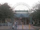
S9 Shopper Hopper - servicing Glenfield Station - Frank Widdon Masonic Homes - Glenquarie Shopping Centre
For Timetables, Maps and More Information please visit http://www.interlinebus.com.au/bus-services.html http://www.interlinebus.com.au/bus-services.html
There is also a number of sporting fields in the town. Sporting fields include Hazlet Oval, Monarch Oval and Third Avenue.
with a diverse community. According to the 2006 Australian Bureau of Statistics
Census
, it had a population of 12,973 people. Languages spoken in the area included Arabic
(4%), Samoan
(2.8%), Hindi (2.6%), Bengali
(2%) and Spanish
(1.8%). The unemployment rate (10.6%) was more than double the national average and the median family income ($1005 per week) was slightly lower than average. The most common occupations were clerical and administrative (18%), technicians and tradespeople (16%), labourers (15%) and machinery operators and drivers (14%).
Suburb
The word suburb mostly refers to a residential area, either existing as part of a city or as a separate residential community within commuting distance of a city . Some suburbs have a degree of administrative autonomy, and most have lower population density than inner city neighborhoods...
of Sydney
Sydney
Sydney is the most populous city in Australia and the state capital of New South Wales. Sydney is located on Australia's south-east coast of the Tasman Sea. As of June 2010, the greater metropolitan area had an approximate population of 4.6 million people...
, in the state of New South Wales
New South Wales
New South Wales is a state of :Australia, located in the east of the country. It is bordered by Queensland, Victoria and South Australia to the north, south and west respectively. To the east, the state is bordered by the Tasman Sea, which forms part of the Pacific Ocean. New South Wales...
, Australia
Australia
Australia , officially the Commonwealth of Australia, is a country in the Southern Hemisphere comprising the mainland of the Australian continent, the island of Tasmania, and numerous smaller islands in the Indian and Pacific Oceans. It is the world's sixth-largest country by total area...
. Macquarie Fields is located 42 kilometres south-west of the Sydney central business district
Sydney central business district
The Sydney central business district is the main commercial centre of Sydney, New South Wales, Australia. It extends southwards for about 3 kilometres from Sydney Cove, the point of first European settlement. Its north–south axis runs from Circular Quay in the north to Central railway station in...
, in the local government area of the City of Campbelltown and is part of the Macarthur
Macarthur, New South Wales
Macarthur is a region in south-west of Sydney, in the state of New South Wales, Australia. The region includes the local government areas of the City of Campbelltown, Camden Council and Wollondilly Shire. It covers an area of 3,067 square kilometres and has a population of close to 240,000 residents...
region.
Macquarie Fields has a mix of public and private housing and is surrounded by bushland
Bushland
Bushland is any area in Australia that is predominantly indigenous flora and fauna.Bushland is the term commonly used by conservation protection groups and other environmental groups as a blanket term for natural vegetation, which may cover any kind of habitat from open shrubby country with few...
. Nearby Macquarie Links
Macquarie Links, New South Wales
Macquarie Links is a suburb of Sydney, in the state of New South Wales, Australia. Macquarie Links is located 42 kilometres south-west of the Sydney central business district, in the local government area of the City of Campbelltown and is part of the Macarthur region.Macquarie Links is a gated...
, is a high-security housing estate based around an international standard golf course
Golf course
A golf course comprises a series of holes, each consisting of a teeing ground, fairway, rough and other hazards, and a green with a flagstick and cup, all designed for the game of golf. A standard round of golf consists of playing 18 holes, thus most golf courses have this number of holes...
.
History
The original inhabitants of the Macquarie Fields area were the Darug peopleDarug people
The Darug people are a language group of Indigenous Australians, who are traditional custodians of much of what is modern day Sydney. There is some dispute about the extent of the Darug nation. Some historians believe the coastal Eora people were a separate tribe to the Darug...
of western Sydney. The rich soil of the area was home to an abundance of plants which in turn attracted animals such as kangaroo
Kangaroo
A kangaroo is a marsupial from the family Macropodidae . In common use the term is used to describe the largest species from this family, especially those of the genus Macropus, Red Kangaroo, Antilopine Kangaroo, Eastern Grey Kangaroo and Western Grey Kangaroo. Kangaroos are endemic to the country...
s and emu
Emu
The Emu Dromaius novaehollandiae) is the largest bird native to Australia and the only extant member of the genus Dromaius. It is the second-largest extant bird in the world by height, after its ratite relative, the ostrich. There are three subspecies of Emus in Australia...
s, both of which along with yam
Yam (vegetable)
Yam is the common name for some species in the genus Dioscorea . These are perennial herbaceous vines cultivated for the consumption of their starchy tubers in Africa, Asia, Latin America and Oceania...
s and other native vegetables and fruit were part of the diet of the Darug. They lived in small huts called gunyahs, made spears, tomahawks and boomerang
Boomerang
A boomerang is a flying tool with a curved shape used as a weapon or for sport.-Description:A boomerang is usually thought of as a wooden device, although historically boomerang-like devices have also been made from bones. Modern boomerangs used for sport are often made from carbon fibre-reinforced...
s for hunting and had an elaborate system of tribal law and rituals with its origins in the Dreamtime
Dreamtime
In the animist framework of Australian Aboriginal mythology, The Dreaming is a sacred era in which ancestral Totemic Spirit Beings formed The Creation.-The Dreaming of the Aboriginal times:...
. However, following the arrival of the First Fleet
First Fleet
The First Fleet is the name given to the eleven ships which sailed from Great Britain on 13 May 1787 with about 1,487 people, including 778 convicts , to establish the first European colony in Australia, in the region which Captain Cook had named New South Wales. The fleet was led by Captain ...
in 1788, they were pushed off their land by the British settlers.
Macquarie Fields was named by early landholder James Meehan in honour of the Governor of New South Wales, Lachlan Macquarie
Lachlan Macquarie
Major-General Lachlan Macquarie CB , was a British military officer and colonial administrator. He served as the last autocratic Governor of New South Wales, Australia from 1810 to 1821 and had a leading role in the social, economic and architectural development of the colony...
. The area was surveyed by Meehan in the early 19th century. Although transported to Australia as a convict for his role in the Irish Rebellion of 1798
Irish Rebellion of 1798
The Irish Rebellion of 1798 , also known as the United Irishmen Rebellion , was an uprising in 1798, lasting several months, against British rule in Ireland...
, Meehan had trained as a surveyor
Surveying
See Also: Public Land Survey SystemSurveying or land surveying is the technique, profession, and science of accurately determining the terrestrial or three-dimensional position of points and the distances and angles between them...
in Ireland and in 1803 was appointed assistant to NSW Surveyor-General Charles Grimes. In 1806 he was granted a full pardon and in 1810 became Surveyor-General. For his work, he was granted a number of parcels of land including 2020 acres (8.2 km²) in what is now Macquarie Fields and neighbouring suburbs. He used the rich soil to grow cereal crops, fruit trees and to graze livestock. In 1883, then owner William Phillips subdivided the land to create a new town he called Glenwood Estate with grand boulevards and fine buildings. A railway station was added to the line in 1888 but the depression of the 1890s meant the grand town failed to materialise with only a few small houses built on the lots. In the next Great Depression
Great Depression
The Great Depression was a severe worldwide economic depression in the decade preceding World War II. The timing of the Great Depression varied across nations, but in most countries it started in about 1929 and lasted until the late 1930s or early 1940s...
of the 1930s, the area became popular with the homeless who made makeshift huts not unlike those of the earlier Darug people.
After World War II
World War II
World War II, or the Second World War , was a global conflict lasting from 1939 to 1945, involving most of the world's nations—including all of the great powers—eventually forming two opposing military alliances: the Allies and the Axis...
, the village grew steadily. A public school was opened in 1958 and by 1971, the population reached 3700. Around this time, a large Housing Commission development was built on the east side of town. This led to a huge population growth and there was even talk of splitting the suburb in two with the newer Housing Commission area taking the name Glenwood but opposition to the proposal put an end to that idea. Private housing developments sprung up further around and the weight of population contributed to a larger town centre.
Macquarie Fields gained notoriety as the location of riots in 2005. Allegations were made that these were the result of the Housing Commission area being something of a ghetto. Since then, there has been a move to sell or demolish many of those houses, moves which are resisted by tenants, some of whom have lived there for thirty years or more.
Notable people
Brett EmertonBrett Emerton
Brett Michael Emerton is an Australian football player who plays for Sydney FC and the Australia national team...
attended Macquarie Fields Public School and Macquarie Fields High School and played for the local soccer club, Gunners United Soccer Club.
Transport
South railway line, Sydney
The South Line is a railway line in Sydney, New South Wales, Australia, and is part of the CityRail suburban network...
, Cumberland and East Hills lines of the CityRail
CityRail
CityRail is an operating brand of RailCorp, a corporation owned by the state government of New South Wales, Australia. It is responsible for providing commuter rail services, and some coach services, in and around Sydney, Newcastle and Wollongong, the three largest cities of New South Wales. It is...
network.
Macquarie Fields is serviced by five Interline/Busabout bus routes:
870 Campbelltown Hospital to Liverpool Station
871 Campbelltown Hospital to Liverpool Station
872 Campbelltown Hospital to Liverpool Station
876 Eucalyptus Drive to Macquarie Fields Station
S9 Shopper Hopper - servicing Glenfield Station - Frank Widdon Masonic Homes - Glenquarie Shopping Centre
For Timetables, Maps and More Information please visit http://www.interlinebus.com.au/bus-services.html http://www.interlinebus.com.au/bus-services.html
Schools
- Macquarie Fields High SchoolMacquarie Fields High SchoolMacquarie Fields High School is a co-educational, academically selective high school in Macquarie Fields, Sydney, Australia....
(public, high school) - James Meehan High SchoolJames Meehan High SchoolJames Meehan High School is a high school in New South Wales, Australia. It is situated in the metropolitan south-west region of Sydney in the local government area of Campbelltown City. The address is 58 Harold Street, Macquarie Fields....
(public, high school) - Macquarie Fields Public School (public, primary school)
- Guise Public School (public, primary school)
- Curran Public School (public, primary school)
- Macarthur Adventist CollegeMacarthur Adventist CollegeMacarthur Adventist College is a K-12 Christian school situated in the Sydney suburb of Macquarie Fields, Australia, and educates over 180 students each year.- See also :* Seventh-day Adventist education* List of Seventh-day Adventist secondary schools...
(private Christian, K-12)
Sport and recreation
The town is home to Macquarie Fields Leisure Centre, which contains an indoor aquatic centre and an outdoor olympic sized swimming pool. It also encompasses a gymnasium and indoor sports facilities.There is also a number of sporting fields in the town. Sporting fields include Hazlet Oval, Monarch Oval and Third Avenue.
Population
Macquarie Fields is a suburbSuburb
The word suburb mostly refers to a residential area, either existing as part of a city or as a separate residential community within commuting distance of a city . Some suburbs have a degree of administrative autonomy, and most have lower population density than inner city neighborhoods...
with a diverse community. According to the 2006 Australian Bureau of Statistics
Australian Bureau of Statistics
The Australian Bureau of Statistics is Australia's national statistical agency. It was created as the Commonwealth Bureau of Census and Statistics on 8 December 1905, when the Census and Statistics Act 1905 was given Royal assent. It had its beginnings in section 51 of the Constitution of Australia...
Census
Census
A census is the procedure of systematically acquiring and recording information about the members of a given population. It is a regularly occurring and official count of a particular population. The term is used mostly in connection with national population and housing censuses; other common...
, it had a population of 12,973 people. Languages spoken in the area included Arabic
Arabic language
Arabic is a name applied to the descendants of the Classical Arabic language of the 6th century AD, used most prominently in the Quran, the Islamic Holy Book...
(4%), Samoan
Samoan language
Samoan Samoan Samoan (Gagana Sāmoa, is the language of the Samoan Islands, comprising the independent country of Samoa and the United States territory of American Samoa. It is an official language—alongside English—in both jurisdictions. Samoan, a Polynesian language, is the first language for most...
(2.8%), Hindi (2.6%), Bengali
Bengali language
Bengali or Bangla is an eastern Indo-Aryan language. It is native to the region of eastern South Asia known as Bengal, which comprises present day Bangladesh, the Indian state of West Bengal, and parts of the Indian states of Tripura and Assam. It is written with the Bengali script...
(2%) and Spanish
Spanish language
Spanish , also known as Castilian , is a Romance language in the Ibero-Romance group that evolved from several languages and dialects in central-northern Iberia around the 9th century and gradually spread with the expansion of the Kingdom of Castile into central and southern Iberia during the...
(1.8%). The unemployment rate (10.6%) was more than double the national average and the median family income ($1005 per week) was slightly lower than average. The most common occupations were clerical and administrative (18%), technicians and tradespeople (16%), labourers (15%) and machinery operators and drivers (14%).