

List of tributaries of Larrys Creek
Encyclopedia
Stream
A stream is a body of water with a current, confined within a bed and stream banks. Depending on its locale or certain characteristics, a stream may be referred to as a branch, brook, beck, burn, creek, "crick", gill , kill, lick, rill, river, syke, bayou, rivulet, streamage, wash, run or...
in Lycoming County
Lycoming County, Pennsylvania
-Appalachian Mountains and Allegheny Plateau:Lycoming County is divided between the Appalachian Mountains in the south, the dissected Allegheny Plateau in the north and east, and the valley of the West Branch Susquehanna River between these.-West Branch Susquehanna River:The West Branch of the...
in the U.S. state
U.S. state
A U.S. state is any one of the 50 federated states of the United States of America that share sovereignty with the federal government. Because of this shared sovereignty, an American is a citizen both of the federal entity and of his or her state of domicile. Four states use the official title of...
of Pennsylvania
Pennsylvania
The Commonwealth of Pennsylvania is a U.S. state that is located in the Northeastern and Mid-Atlantic regions of the United States. The state borders Delaware and Maryland to the south, West Virginia to the southwest, Ohio to the west, New York and Ontario, Canada, to the north, and New Jersey to...
. Larrys Creek
Larrys Creek
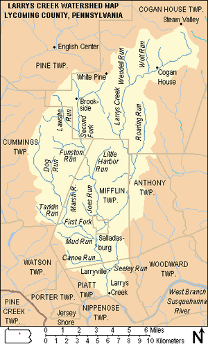
Larrys Creek is a tributary of the West Branch Susquehanna River in Lycoming County in the U.S. state of Pennsylvania. A part of the Chesapeake Bay drainage basin, its watershed drains in six townships and a borough...
is a tributary
Tributary
A tributary or affluent is a stream or river that flows into a main stem river or a lake. A tributary does not flow directly into a sea or ocean...
of the West Branch Susquehanna River
West Branch Susquehanna River
The West Branch Susquehanna River is one of the two principal branches, along with the North Branch, of the Susquehanna River in the northeastern United States. The North Branch, which rises in upstate New York, is generally regarded as the extension of the main branch, with the shorter West Branch...
and part of the Chesapeake Bay
Chesapeake Bay
The Chesapeake Bay is the largest estuary in the United States. It lies off the Atlantic Ocean, surrounded by Maryland and Virginia. The Chesapeake Bay's drainage basin covers in the District of Columbia and parts of six states: New York, Pennsylvania, Delaware, Maryland, Virginia, and West...
drainage basin
Drainage basin
A drainage basin is an extent or an area of land where surface water from rain and melting snow or ice converges to a single point, usually the exit of the basin, where the waters join another waterbody, such as a river, lake, reservoir, estuary, wetland, sea, or ocean...
; its watershed drains 89.1 square miles (230.8 km²) in six townships
Township (Pennsylvania)
A township in the Commonwealth of Pennsylvania, a state of the United States of America, is one of four types of municipalities in the state . Townships were established based on convenient geographical boundaries and vary in size from six to forty square miles...
and a borough. Despite being clear-cut
Clearcutting
Clearcutting, or clearfelling, is a controversial forestry/logging practice in which most or all trees in an area are uniformly cut down. Clearcutting, along with shelterwood and seed tree harvests, is used by foresters to create certain types of forest ecosystems and to promote select species that...
in the 19th century, as of 2008 the Larrys Creek watershed is 83.1% forest and 15.7% agricultural.
The named tributaries within the watershed are presented here in three lists. Larrys Creek itself has 18 named tributaries, which are the subject of the first list. The First Fork and Second Fork of Larrys Creek are the two main tributaries of Larrys Creek, and they have multiple tributaries of their own. The second list gives the First Fork's eight named tributaries, and the third list gives the Second Fork's nine named tributaries. Finally there are seven named streams in the watershed which are tributaries of tributaries of the three main branches, and they are presented after each list. There is one such stream for Larrys Creek itself, two for the First Fork, and four for the Second Fork. There are also tributaries without names, but they are not included in these lists.
Each list follows the same format. The first column gives the name—27 of the tributaries are named streams, while the remaining 15 are unnamed streams in named valleys: i.e. 13 hollows, one cove
Cove (Appalachian Mountains)
In the central and southern Appalachian Mountains of Eastern North America, a cove is a small valley between two ridge lines that is closed at one or both ends....
, and one swale
Swale (geographical feature)
A swale is a low tract of land, especially one that is moist or marshy. The term can refer to a natural landscape feature or a human-created one...
. Tributaries which are themselves unnamed, but which are in a named valley are given the name of the feature in quotation marks, for example: "Pond Hollow". The first column also notes whether the tributary enters its parent stream on the right bank or left bank. The second column in each list gives the river mile
River mile
In the United States, a River mile is a measure of distance in miles along a river from its mouth. River mile numbers begin at zero and increase further upstream. The corresponding metric unit using kilometers is the River kilometer...
s, which is the distance from the mouth of the tributary to the mouth of its parent stream (Larrys Creek or the First or Second Fork). The third column gives the area of the drainage basin
Drainage basin
A drainage basin is an extent or an area of land where surface water from rain and melting snow or ice converges to a single point, usually the exit of the basin, where the waters join another waterbody, such as a river, lake, reservoir, estuary, wetland, sea, or ocean...
or watershed for that stream. The next four columns give the latitude and longitude and the elevation of the mouth and source of each tributary, and the final column has remarks, mostly about location.
Tributaries
Larrys Creek flows south from the dissected Allegheny PlateauAllegheny Plateau
The Allegheny Plateau is a large dissected plateau area in western and central New York, northern and western Pennsylvania, northern and western West Virginia, and eastern Ohio...
to the Ridge-and-valley Appalachians
Ridge-and-valley Appalachians
The Ridge-and-Valley Appalachians, also called the Ridge and Valley Province or the Valley and Ridge Appalachians, are a physiographic province of the larger Appalachian division and are also a belt within the Appalachian Mountains extending from southeastern New York through northwestern New...
. It rises in Cogan House Township
Cogan House Township, Pennsylvania
Cogan House Township is a township in Lycoming County, Pennsylvania, in the United States. The population was 974 at the 2000 census. It is part of the Williamsport, Pennsylvania Metropolitan Statistical Area.-History:...
and flows south to Green Mountain. There it turns southwest and flows under the Cogan House Covered Bridge
Cogan House Covered Bridge
The Cogan House Covered Bridge is a Burr arch truss covered bridge over Larrys Creek in Cogan House Township, Lycoming County in the U.S. state of Pennsylvania. It was built in 1877 and is long. The bridge was placed on the National Register of Historic Places in 1980, and had a major restoration...
, which is on the National Register of Historic Places
National Register of Historic Places
The National Register of Historic Places is the United States government's official list of districts, sites, buildings, structures, and objects deemed worthy of preservation...
and one of only three remaining covered bridges in Lycoming County. At Buckhorn Mountain it turns south through Pennsylvania State Game Lands
Pennsylvania State Game Lands
The Pennsylvania State Game Lands are lands managed by the Pennsylvania Game Commission for hunting, trapping, and fishing. These lands, often not usable for farming or development, are donated to the PGC or purchased by the PGC with hunting license monies.The Pennsylvania Game Commission runs a...
(SGL) No. 114 and flows through Mifflin and Anthony Townships, passing between Coal Mountain and Harris Point. From Mifflin Township it enters the borough of Salladasburg, where it receives the Second Fork, and just south of the borough the First Fork joins the creek. These two largest tributaries drain parts of Pine, Cogan House, Cummings, and Mifflin Townships (there are named streams in the Larrys Creek watershed in all but Pine Township). Piatt Township is the last municipality the creek flows through and it enters the West Branch Susquehanna River there.
The five largest direct tributaries in the Larrys Creek watershed are the First and Second Forks of Larrys Creek, Roaring Run, Wendell Run and Wolf Run. The Second Fork of Larrys Creek is the largest tributary, with a watershed of 24.9 square miles (64.5 km²) or 28.0% of the total watershed. The First Fork is next largest, with a watershed of 17.6 square miles (45.6 km²) or 19.8% of the total. Roaring Run accounts for 5.7% of the total watershed (5.1 square miles or 13.2 km2) and other tributaries are less than 5% of the total area.
Main stem tributaries
| Name, bank |
River miles River mile In the United States, a River mile is a measure of distance in miles along a river from its mouth. River mile numbers begin at zero and increase further upstream. The corresponding metric unit using kilometers is the River kilometer... (km) |
Watershed area in square miles (km2) |
Mouth coordinates |
Mouth elevation in feet (m) |
Source coordinates |
Source elevation in feet (m) |
Remarks |
|---|---|---|---|---|---|---|---|
| Mouth River delta A delta is a landform that is formed at the mouth of a river where that river flows into an ocean, sea, estuary, lake, reservoir, flat arid area, or another river. Deltas are formed from the deposition of the sediment carried by the river as the flow leaves the mouth of the river... |
0 mi (0 km) |
mi2 (230.8 km2) |
41°13′00"N 77°13′13"W | 515 ft (157 m) |
-- | -- | Larrys Creek enters the West Branch Susquehanna River West Branch Susquehanna River The West Branch Susquehanna River is one of the two principal branches, along with the North Branch, of the Susquehanna River in the northeastern United States. The North Branch, which rises in upstate New York, is generally regarded as the extension of the main branch, with the shorter West Branch... in Piatt Township Piatt Township, Pennsylvania Piatt Township is a township in Lycoming County, Pennsylvania, in the United States. The population was 1,259 at the 2000 census. It is part of the Williamsport, Pennsylvania Metropolitan Statistical Area.-History:... at the hamlet of Larrys Creek. |
| Seeley Run, left bank |
mi (2.93 km) |
mi2 (3.78 km2) |
41°14′26"N 77°12′56"W | 554 ft (169 m) |
41°15′56"N 77°12′23"W | 1005 feet (306 m) |
Mouth at the village of Larryville in Piatt Township Piatt Township, Pennsylvania Piatt Township is a township in Lycoming County, Pennsylvania, in the United States. The population was 1,259 at the 2000 census. It is part of the Williamsport, Pennsylvania Metropolitan Statistical Area.-History:... , source in Mifflin Township Mifflin Township, Lycoming County, Pennsylvania Mifflin Township is a township in Lycoming County, Pennsylvania, in the United States. The population was 1,145 at the 2000 census. It is part of the Williamsport, Pennsylvania Metropolitan Statistical Area.- History :... |
| Canoe Run, right bank |
mi (4.54 km) |
mi2 (5.46 km2) |
41°14′50"N 77°13′35"W | 577 ft (176 m) |
41°15′21"N 77°15′57"W | 928 feet (283 m) |
Entirely within Piatt Township Piatt Township, Pennsylvania Piatt Township is a township in Lycoming County, Pennsylvania, in the United States. The population was 1,259 at the 2000 census. It is part of the Williamsport, Pennsylvania Metropolitan Statistical Area.-History:... |
| First Fork Larrys Creek, right bank |
mi (6.76 km) |
mi2 (45.58 km2) |
41°15′54"N 77°13′57"W | 617 ft (188 m) |
41°22′14"N 77°17′45"W | 2,040 feet (622 m) |
Mouth just south of Salladasburg in Piatt Township Piatt Township, Pennsylvania Piatt Township is a township in Lycoming County, Pennsylvania, in the United States. The population was 1,259 at the 2000 census. It is part of the Williamsport, Pennsylvania Metropolitan Statistical Area.-History:... , source in Cummings Township Cummings Township, Pennsylvania Cummings Township is a township in Lycoming County, Pennsylvania, in the United States. The population was 355 at the 2000 census. It is part of the Williamsport, Pennsylvania Metropolitan Statistical Area... |
| Second Fork Larrys Creek, right bank |
mi (9.27 km) |
mi2 (64.49 km2) |
41°16′53"N 77°13′24"W | 666 ft (203 m) |
41°24′34"N 77°13′19"W | 1,670 feet (509 m) |
Mouth in Salladasburg, source in Cogan House Township Cogan House Township, Pennsylvania Cogan House Township is a township in Lycoming County, Pennsylvania, in the United States. The population was 974 at the 2000 census. It is part of the Williamsport, Pennsylvania Metropolitan Statistical Area.-History:... near the village of White Pine |
| Mash Run, right bank |
mi (15.35 km) |
mi2 (3.08 km2) |
41°19′21"N 77°11′28"W | 873 ft (266 m) |
41°19′03"N 77°12′56"W | 1,635 feet (498 m) |
Mouth in Anthony Township Anthony Township, Lycoming County, Pennsylvania Anthony Township is a township in Lycoming County, Pennsylvania, in the United States. The population was 904 at the 2000 census. It is part of the Williamsport, Pennsylvania Metropolitan Statistical Area.-History:... , source in Mifflin Township Mifflin Township, Lycoming County, Pennsylvania Mifflin Township is a township in Lycoming County, Pennsylvania, in the United States. The population was 1,145 at the 2000 census. It is part of the Williamsport, Pennsylvania Metropolitan Statistical Area.- History :... , just north of Harris Point |
| , left bank |
mi (15.93 km) |
mi2 (1.04 km2) |
41°19′40"N 77°11′15"W | 919 ft (260 m) |
41°20′08"N 77°10′35"W | 1,690 feet (515 m) |
Entirely in Anthony Township Anthony Township, Lycoming County, Pennsylvania Anthony Township is a township in Lycoming County, Pennsylvania, in the United States. The population was 904 at the 2000 census. It is part of the Williamsport, Pennsylvania Metropolitan Statistical Area.-History:... , on the west side of Coal Mountain |
| , right bank |
mi (16.70 km) |
mi2 (1.99 km2) |
41°19′57"N 77°11′26"W | 935 ft (285 m) |
41°20′24"N 77°12′47"W | 1,640 feet (500 m) |
Mouth in Anthony Township Anthony Township, Lycoming County, Pennsylvania Anthony Township is a township in Lycoming County, Pennsylvania, in the United States. The population was 904 at the 2000 census. It is part of the Williamsport, Pennsylvania Metropolitan Statistical Area.-History:... , source in Mifflin Township Mifflin Township, Lycoming County, Pennsylvania Mifflin Township is a township in Lycoming County, Pennsylvania, in the United States. The population was 1,145 at the 2000 census. It is part of the Williamsport, Pennsylvania Metropolitan Statistical Area.- History :... in SGL Pennsylvania State Game Lands The Pennsylvania State Game Lands are lands managed by the Pennsylvania Game Commission for hunting, trapping, and fishing. These lands, often not usable for farming or development, are donated to the PGC or purchased by the PGC with hunting license monies.The Pennsylvania Game Commission runs a... No. 114 |
| Roaring Run, left bank |
mi (16.74 km) |
mi2 (13.23 km2) |
41°20′01"N 77°11′22"W | 937 ft (286 m) |
41°23′27"N 77°10′43"W | 1,795 feet (547 m) |
Mouth in Anthony Township Anthony Township, Lycoming County, Pennsylvania Anthony Township is a township in Lycoming County, Pennsylvania, in the United States. The population was 904 at the 2000 census. It is part of the Williamsport, Pennsylvania Metropolitan Statistical Area.-History:... , source in Cogan House Township Cogan House Township, Pennsylvania Cogan House Township is a township in Lycoming County, Pennsylvania, in the United States. The population was 974 at the 2000 census. It is part of the Williamsport, Pennsylvania Metropolitan Statistical Area.-History:... , on the west side of Coal Mountain |
| , right bank |
mi (18.15 km) |
mi2 (0.96 km2) |
41°20′37"N 77°11′47"W | 984 ft (300 m) |
41°20′32"N 77°12′55"W | 1,605 feet (489 m) |
Mouth in Anthony Township Anthony Township, Lycoming County, Pennsylvania Anthony Township is a township in Lycoming County, Pennsylvania, in the United States. The population was 904 at the 2000 census. It is part of the Williamsport, Pennsylvania Metropolitan Statistical Area.-History:... , source in Mifflin Township Mifflin Township, Lycoming County, Pennsylvania Mifflin Township is a township in Lycoming County, Pennsylvania, in the United States. The population was 1,145 at the 2000 census. It is part of the Williamsport, Pennsylvania Metropolitan Statistical Area.- History :... in SGL Pennsylvania State Game Lands The Pennsylvania State Game Lands are lands managed by the Pennsylvania Game Commission for hunting, trapping, and fishing. These lands, often not usable for farming or development, are donated to the PGC or purchased by the PGC with hunting license monies.The Pennsylvania Game Commission runs a... No. 114 |
| , left bank |
mi (18.60 km) |
mi2 (1.06 km2) |
41°20′51"N 77°11′49"W | 1,027 ft (313 m) |
41°21′29"N 77°11′05"W | 1,700 feet (518 m) |
Mouth in Mifflin Township Mifflin Township, Lycoming County, Pennsylvania Mifflin Township is a township in Lycoming County, Pennsylvania, in the United States. The population was 1,145 at the 2000 census. It is part of the Williamsport, Pennsylvania Metropolitan Statistical Area.- History :... , source in Cogan House Township Cogan House Township, Pennsylvania Cogan House Township is a township in Lycoming County, Pennsylvania, in the United States. The population was 974 at the 2000 census. It is part of the Williamsport, Pennsylvania Metropolitan Statistical Area.-History:... , entirely in SGL Pennsylvania State Game Lands The Pennsylvania State Game Lands are lands managed by the Pennsylvania Game Commission for hunting, trapping, and fishing. These lands, often not usable for farming or development, are donated to the PGC or purchased by the PGC with hunting license monies.The Pennsylvania Game Commission runs a... No. 114, on the west side of Coal Mountain |
| , right bank |
mi (19.30 km) |
mi2 (0.57 km2) |
41°21′05"N 77°12′08"W | 1,033 ft (315 m) |
41°21′19"N 77°12′55"W | 1,680 feet (514 m) |
Entirely in Mifflin Township Mifflin Township, Lycoming County, Pennsylvania Mifflin Township is a township in Lycoming County, Pennsylvania, in the United States. The population was 1,145 at the 2000 census. It is part of the Williamsport, Pennsylvania Metropolitan Statistical Area.- History :... , mouth in SGL Pennsylvania State Game Lands The Pennsylvania State Game Lands are lands managed by the Pennsylvania Game Commission for hunting, trapping, and fishing. These lands, often not usable for farming or development, are donated to the PGC or purchased by the PGC with hunting license monies.The Pennsylvania Game Commission runs a... No. 114, on the west side of Coal Mountain |
| , left bank |
mi (19.86 km) |
mi2 (1.04 km2) |
41°21′22"N 77°12′13"W | 1,083 ft (330 m) |
41°22′08"N 77°11′31"W | 1,770 feet (539 m) |
Mouth at the border of Mifflin Mifflin Township, Lycoming County, Pennsylvania Mifflin Township is a township in Lycoming County, Pennsylvania, in the United States. The population was 1,145 at the 2000 census. It is part of the Williamsport, Pennsylvania Metropolitan Statistical Area.- History :... and Cogan House Townships Cogan House Township, Pennsylvania Cogan House Township is a township in Lycoming County, Pennsylvania, in the United States. The population was 974 at the 2000 census. It is part of the Williamsport, Pennsylvania Metropolitan Statistical Area.-History:... , source in Cogan House Township, mouth in SGL Pennsylvania State Game Lands The Pennsylvania State Game Lands are lands managed by the Pennsylvania Game Commission for hunting, trapping, and fishing. These lands, often not usable for farming or development, are donated to the PGC or purchased by the PGC with hunting license monies.The Pennsylvania Game Commission runs a... No. 114 |
| Long Run, right bank |
mi (20.25 km) |
mi2 (4.79 km2) |
41°21′33"N 77°12′20"W | 1,122 ft (342 m) |
41°22′51"N 77°13′02"W | 1,885 feet (575 m) |
Entirely in Cogan House Township Cogan House Township, Pennsylvania Cogan House Township is a township in Lycoming County, Pennsylvania, in the United States. The population was 974 at the 2000 census. It is part of the Williamsport, Pennsylvania Metropolitan Statistical Area.-History:... |
| Wendell Run, right bank |
mi (26.07 km) |
mi2 (7.49 km2) |
41°24′14"N 77°11′40"W | 1,283 ft (391 m) |
41°26′13"N 77°11′47"W | 1,525 feet (465 m) |
Entirely in Cogan House Township Cogan House Township, Pennsylvania Cogan House Township is a township in Lycoming County, Pennsylvania, in the United States. The population was 974 at the 2000 census. It is part of the Williamsport, Pennsylvania Metropolitan Statistical Area.-History:... , mouth just upstream of Cogan House Covered Bridge Cogan House Covered Bridge The Cogan House Covered Bridge is a Burr arch truss covered bridge over Larrys Creek in Cogan House Township, Lycoming County in the U.S. state of Pennsylvania. It was built in 1877 and is long. The bridge was placed on the National Register of Historic Places in 1980, and had a major restoration... |
| Crayton Hollow Run, left bank |
mi (27.17 km) |
mi2 (0.98 km2) |
41°24′37"N 77°11′14"W | 1,322 ft (403 m) |
41°24′02"N 77°10′40"W | 1,780 feet (543 m) |
Entirely in Cogan House Township Cogan House Township, Pennsylvania Cogan House Township is a township in Lycoming County, Pennsylvania, in the United States. The population was 974 at the 2000 census. It is part of the Williamsport, Pennsylvania Metropolitan Statistical Area.-History:... , on the north side of Buckhorn Mountain |
| Wolf Run, right bank |
mi (28.90 km) |
mi2 (5.75 km2) |
41°24′52"N 77°10′24"W | 1,352 ft (412 m) |
41°27′07"N 77°10′36"W | 1,635 feet (498 m) |
Entirely in Cogan House Township Cogan House Township, Pennsylvania Cogan House Township is a township in Lycoming County, Pennsylvania, in the United States. The population was 974 at the 2000 census. It is part of the Williamsport, Pennsylvania Metropolitan Statistical Area.-History:... |
| Dibber Hollow Run, left bank |
mi (29.64 km) |
mi2 (0.85 km2) |
41°24′59"N 77°10′01"W | 1,358 ft (414 m) |
41°24′24"N 77°09′43"W | 1,740 feet (530 m) |
Entirely in Cogan House Township Cogan House Township, Pennsylvania Cogan House Township is a township in Lycoming County, Pennsylvania, in the United States. The population was 974 at the 2000 census. It is part of the Williamsport, Pennsylvania Metropolitan Statistical Area.-History:... , on the north side of Green and Buckhorn Mountains, with the mouth just downstream of village of Cogan House |
| Birch Run, left bank |
mi (30.82 km) |
mi2 (1.92 km2) |
41°25′16"N 77°09′15"W | 1,394 ft (425 m) |
41°24′18"N 77°09′04"W | 1,770 feet (539 m) |
Entirely in Cogan House Township Cogan House Township, Pennsylvania Cogan House Township is a township in Lycoming County, Pennsylvania, in the United States. The population was 974 at the 2000 census. It is part of the Williamsport, Pennsylvania Metropolitan Statistical Area.-History:... , on the north side of Green Mountain with the mouth just upstream of the village of Cogan House |
| Source Source (river or stream) The source or headwaters of a river or stream is the place from which the water in the river or stream originates.-Definition:There is no universally agreed upon definition for determining a stream's source... |
mi (36.9 km) |
0 mi2 (0 km2) |
-- | -- | 41°27′13"N 77°08′12"W | 1,740 ft (530 m) |
The source of Larrys Creek is in Cogan House Township Cogan House Township, Pennsylvania Cogan House Township is a township in Lycoming County, Pennsylvania, in the United States. The population was 974 at the 2000 census. It is part of the Williamsport, Pennsylvania Metropolitan Statistical Area.-History:... , just south of the hamlet of Steam Valley. |
Wendell Run, itself a tributary of Larrys Creek, has one named tributary: Buck Run.
| Buck Run, left bank (of Wendell Run) |
mi (2.25 km) |
mi2 (1.17 km2) |
41°25′26"N 77°11′55"W | 1,411 ft (430 m) |
41°25′55"N 77°11′12"W | 1600 feet (488 m) |
Entirely in Cogan House Township Cogan House Township, Pennsylvania Cogan House Township is a township in Lycoming County, Pennsylvania, in the United States. The population was 974 at the 2000 census. It is part of the Williamsport, Pennsylvania Metropolitan Statistical Area.-History:... |
First Fork tributaries
The First Fork is the second largest tributary and has its source in Cummings Township. It flows south-southeast passing to the southwest of Little Round Top and Puterbaugh Mountain, then leaves the dissected Allegheny Plateau at Fishery Point. It then enters Mifflin Township, where it joins Larrys Creek just south of Salladasburg, 4.2 miles (6.8 km) from the mouth. Historically, much of the First Fork was protected as part of the Ogontz Lodge, a private hunting and fishing club.The four largest tributaries of the First Fork are: Tarkiln Run with a watershed of 2.71 square miles (7 km²) or 15.4% of the First Fork watershed; Mud Run with 2.22 square miles (5.75 km2 or 12.6%); Dog Run with 1.82 square miles (4.71 km2 or 10.3%); and Marsh Run with 0.96 square miles (2.49 km2 or 5.5%). All other tributaries are less than 5% of the total area.
| Name, bank |
River miles River mile In the United States, a River mile is a measure of distance in miles along a river from its mouth. River mile numbers begin at zero and increase further upstream. The corresponding metric unit using kilometers is the River kilometer... (km) |
Watershed area in square miles (km2) |
Mouth coordinates |
Mouth elevation in feet (m) |
Source coordinates |
Source elevation in feet (m) |
Remarks |
|---|---|---|---|---|---|---|---|
| Mouth | 0 mi (0 km) |
mi2 (45.58 km2) |
41°15′54"N 77°13′57"W | 617 ft (188 m) |
-- | -- | The First Fork enters Larrys Creek just south of Salladasburg in Piatt Township Piatt Township, Pennsylvania Piatt Township is a township in Lycoming County, Pennsylvania, in the United States. The population was 1,259 at the 2000 census. It is part of the Williamsport, Pennsylvania Metropolitan Statistical Area.-History:... . |
| Mud Run, right bank |
mi (0.51 km) |
mi2 (5.75 km2) |
41°16′01"N 77°14′12"W | 643 ft (196 m) |
41°16′22"N 77°16′47"W | 1,000 feet (305 m) |
Entirely in Mifflin Township Mifflin Township, Lycoming County, Pennsylvania Mifflin Township is a township in Lycoming County, Pennsylvania, in the United States. The population was 1,145 at the 2000 census. It is part of the Williamsport, Pennsylvania Metropolitan Statistical Area.- History :... |
| Tarkiln Run, right bank |
mi (4.54 km) |
mi2 (7.02 km2) |
41°16′52"N 77°16′20"W | 827 ft (252 m) |
41°18′12"N 77°18′26"W | 1,785 feet (544 m) |
Mouth in Mifflin Township Mifflin Township, Lycoming County, Pennsylvania Mifflin Township is a township in Lycoming County, Pennsylvania, in the United States. The population was 1,145 at the 2000 census. It is part of the Williamsport, Pennsylvania Metropolitan Statistical Area.- History :... , source in Cummings Township Cummings Township, Pennsylvania Cummings Township is a township in Lycoming County, Pennsylvania, in the United States. The population was 355 at the 2000 census. It is part of the Williamsport, Pennsylvania Metropolitan Statistical Area... , starts on the west side of Fishery Point |
| Marsh Run, left bank |
mi (6.24 km) |
mi2 (2.49 km2) |
41°17′41"N 77°16′03"W | 948 ft (289 m) |
41°18′38"N 77°15′40"W | 1,775 feet (541 m) |
Entirely in Mifflin Township Mifflin Township, Lycoming County, Pennsylvania Mifflin Township is a township in Lycoming County, Pennsylvania, in the United States. The population was 1,145 at the 2000 census. It is part of the Williamsport, Pennsylvania Metropolitan Statistical Area.- History :... , on the west side of Puterbaugh Mountain |
| Buckhorn Run, left bank |
mi (7.72 km) |
mi2 (2.07 km2) |
41°18′17"N 77°16′33"W | 1,066 ft (325 m) |
41°19′13"N 77°16′08"W | 1,635 feet (498 m) |
Entirely in Cummings Township Cummings Township, Pennsylvania Cummings Township is a township in Lycoming County, Pennsylvania, in the United States. The population was 355 at the 2000 census. It is part of the Williamsport, Pennsylvania Metropolitan Statistical Area... , on the west side of Puterbaugh Mountain |
| , right bank |
mi (8.30 km) |
mi2 (0.54 km2) |
41°18′27"N 77°16′50"W | 1,119 ft (341 m) |
41°18′36"N 77°17′43"W | 1,810 feet (552 m) |
Entirely in Cummings Township Cummings Township, Pennsylvania Cummings Township is a township in Lycoming County, Pennsylvania, in the United States. The population was 355 at the 2000 census. It is part of the Williamsport, Pennsylvania Metropolitan Statistical Area... |
| Dog Run, left bank |
mi (9.46 km) |
mi2 (4.71 km2) |
41°19′00"N 77°17′07"W | 1,220 ft (372 m) |
41°20′34"N 77°16′47"W | 1,675 feet (511 m) |
Entirely in Cummings Township Cummings Township, Pennsylvania Cummings Township is a township in Lycoming County, Pennsylvania, in the United States. The population was 355 at the 2000 census. It is part of the Williamsport, Pennsylvania Metropolitan Statistical Area... , on the west side of Puterbaugh Mountain |
| , right bank |
mi (10.14 km) |
mi2 (1.17 km2) |
41°19′08"N 77°17′32"W | 1,309 ft (399 m) |
41°18′58"N 77°18′35"W | 1,925 feet (587 m) |
Entirely in Cummings Township Cummings Township, Pennsylvania Cummings Township is a township in Lycoming County, Pennsylvania, in the United States. The population was 355 at the 2000 census. It is part of the Williamsport, Pennsylvania Metropolitan Statistical Area... |
| , left bank |
mi (11.27 km) |
mi2 (0.88 km2) |
41°19′40"N 77°17′57"W | 1,430 ft (436 m) |
41°20′07"N 77°17′28"W | 1,760 feet (536 m) |
Entirely in Cummings Township Cummings Township, Pennsylvania Cummings Township is a township in Lycoming County, Pennsylvania, in the United States. The population was 355 at the 2000 census. It is part of the Williamsport, Pennsylvania Metropolitan Statistical Area... , just south of Little Round Top |
| Source Source (river or stream) The source or headwaters of a river or stream is the place from which the water in the river or stream originates.-Definition:There is no universally agreed upon definition for determining a stream's source... |
c. mi (16.7 km) |
0 mi2 (0 km2) |
-- | -- | 41°22′14"N 77°17′45"W | 2,040 feet (622 m) |
The source of the First Fork is in Cummings Township Cummings Township, Pennsylvania Cummings Township is a township in Lycoming County, Pennsylvania, in the United States. The population was 355 at the 2000 census. It is part of the Williamsport, Pennsylvania Metropolitan Statistical Area... , north of Cummings Spring and Little Round Top. |
There are two named tributaries of the First Fork which have their own named tributary: Tarkiln Run has Ritter Run; and Dog Run has Little Dog Run.
| Ritter Run, right bank (of Tarkiln Run) |
mi (1.19 km) |
mi2 (3.03 km2) |
41°16′59"N 77°17′02"W | 984 ft (300 m) |
41°17′53"N 77°18′19"W | 1700 feet (518 m) |
Entirely in Cummings Township Cummings Township, Pennsylvania Cummings Township is a township in Lycoming County, Pennsylvania, in the United States. The population was 355 at the 2000 census. It is part of the Williamsport, Pennsylvania Metropolitan Statistical Area... |
| Little Dog Run, left bank (of Dog Run) |
mi (0.45 km) |
mi2 (1.63 km2) |
41°19′12"N 77°16′57"W | 1,293 ft (394 m) |
41°19′57"N 77°16′23"W | 1810 feet (552 m) |
Entirely in Cummings Township Cummings Township, Pennsylvania Cummings Township is a township in Lycoming County, Pennsylvania, in the United States. The population was 355 at the 2000 census. It is part of the Williamsport, Pennsylvania Metropolitan Statistical Area... , on the west side of Puterbaugh Mountain |
Second Fork tributaries
The Second Fork is the largest tributary and rises in Cogan House Township near the village of White Pine. It runs south through the village of Brookside, then along the east side of Henson Ridge and Puterbaugh Mountain through Cummings and Mifflin Townships. It leaves the dissected Allegheny Plateau at Clapp Point and ends in Salladasburg, where it joins Larrys Creek 5.8 miles (9.3 km) from the mouth. In 1851 a plank road was built from the mouth along Larrys Creek to Salladasburg, then followed the Second Fork as far as the village of English Centre in Pine Township. There was also a spur along the First Fork into Anthony Township and perhaps further. An 1889 flood destroyed much of the plank road, and it ceased operation as a toll road in 1900. Today Pennsylvania Route 287Pennsylvania Route 287
Pennsylvania Route 287 is a long state highway in the Tioga Valley of Pennsylvania. Route 287 begins at an intersection with U.S. Route 220 in the community of Larrys Creek in Piatt Township, Lycoming County to an intersection with Pennsylvania Route 49 just south of the New York state line...
follows its course along the entire length of the Second Fork. Over 6000 acres (2,428.1 ha) along it belongs to the private "Larrys Creek Fish and Game Club".
The three largest tributaries of the Second Fork are: Lawshe Run with a watershed of 3.39 square miles (8.8 km²) or 13.6% of the Second Fork watershed; Funston Run with 2.50 square miles (6.48 km2 or 10.0%); and Little Harbor Run with 2.14 square miles (5.54 km2 or 8.6%). All other tributaries are less than 5% of the total area.
| Name, bank |
River miles River mile In the United States, a River mile is a measure of distance in miles along a river from its mouth. River mile numbers begin at zero and increase further upstream. The corresponding metric unit using kilometers is the River kilometer... (km) |
Watershed area in square miles (km2) |
Mouth coordinates |
Mouth elevation in feet (m) |
Source coordinates |
Source elevation in feet (m) |
Remarks |
|---|---|---|---|---|---|---|---|
| Second Fork Larrys Creek, right bank |
mi (9.27 km) |
mi2 (64.49 km2) |
41°16′53"N 77°13′24"W | 666 ft (203 m) |
-- | -- | The Second Fork enters Larrys Creek in the borough of Salladasburg. |
| Joes Run, right bank |
mi (1.09 km) |
mi2 (2.23 km2) |
41°17′18"N 77°13′49"W | 702 ft (214 m) |
41°18′00"N 77°14′59"W | 1,480 feet (451 m) |
Entirely in Mifflin Township Mifflin Township, Lycoming County, Pennsylvania Mifflin Township is a township in Lycoming County, Pennsylvania, in the United States. The population was 1,145 at the 2000 census. It is part of the Williamsport, Pennsylvania Metropolitan Statistical Area.- History :... , mouth is just north of Salladasburg, starts on the south side of Puterbaugh Mountain |
| , right bank |
mi (4.09 km) |
mi2 (1.42 km2) |
41°18′46"N 77°14′06"W | 830 ft (253 m) |
41°18′51"N 77°14′58"W | 1,600 feet (488 m) |
Entirely in Mifflin Township Mifflin Township, Lycoming County, Pennsylvania Mifflin Township is a township in Lycoming County, Pennsylvania, in the United States. The population was 1,145 at the 2000 census. It is part of the Williamsport, Pennsylvania Metropolitan Statistical Area.- History :... , on the east side of Puterbaugh Mountain |
| Little Harbor Run, left bank |
mi (5.18 km) |
mi2 (5.54 km2) |
41°19′13"N 77°14′12"W | 873 ft (266 m) |
41°21′00"N 77°13′02"W | 1,500 feet (457 m) |
Entirely in Mifflin Township Mifflin Township, Lycoming County, Pennsylvania Mifflin Township is a township in Lycoming County, Pennsylvania, in the United States. The population was 1,145 at the 2000 census. It is part of the Williamsport, Pennsylvania Metropolitan Statistical Area.- History :... , north of Clapp Point |
| Harbor Run, right bank |
mi (5.70 km) |
mi2 (1.55 km2) |
41°19′24"N 77°14′27"W | 896 ft (273 m) |
41°19′20"N 77°15′59"W | 1,645 feet (501 m) |
Mouth in Mifflin Township Mifflin Township, Lycoming County, Pennsylvania Mifflin Township is a township in Lycoming County, Pennsylvania, in the United States. The population was 1,145 at the 2000 census. It is part of the Williamsport, Pennsylvania Metropolitan Statistical Area.- History :... , source in Cummings Township Cummings Township, Pennsylvania Cummings Township is a township in Lycoming County, Pennsylvania, in the United States. The population was 355 at the 2000 census. It is part of the Williamsport, Pennsylvania Metropolitan Statistical Area... , on the east side of Puterbaugh Mountain |
| , left bank |
mi (8.72 km) |
mi2 (1.97 km2) |
41°20′53"N 77°14′49"W | 1,050 ft (320 m) |
41°21′30"N 77°13′36"W | 1,685 feet (514 m) |
Mouth in Cummings Township Cummings Township, Pennsylvania Cummings Township is a township in Lycoming County, Pennsylvania, in the United States. The population was 355 at the 2000 census. It is part of the Williamsport, Pennsylvania Metropolitan Statistical Area... , part in Mifflin Township Mifflin Township, Lycoming County, Pennsylvania Mifflin Township is a township in Lycoming County, Pennsylvania, in the United States. The population was 1,145 at the 2000 census. It is part of the Williamsport, Pennsylvania Metropolitan Statistical Area.- History :... , source in Cogan House Township Cogan House Township, Pennsylvania Cogan House Township is a township in Lycoming County, Pennsylvania, in the United States. The population was 974 at the 2000 census. It is part of the Williamsport, Pennsylvania Metropolitan Statistical Area.-History:... |
| Funston Run, right bank |
mi (8.88 km) |
mi2 (6.48 km2) |
41°20′55"N 77°14′54"W | 1,053 ft (321 m) |
41°21′05"N 77°15′37"W | 1,184 feet (361 m) |
Entirely in Cummings Township Cummings Township, Pennsylvania Cummings Township is a township in Lycoming County, Pennsylvania, in the United States. The population was 355 at the 2000 census. It is part of the Williamsport, Pennsylvania Metropolitan Statistical Area... , north of Henson Ridge; a variant name is Francis Run |
| , left bank |
mi (9.56 km) |
mi2 (1.74 km2) |
41°21′14"N 77°15′02"W | 1,099 ft (335 m) |
41°21′48"N 77°13′52"W | 1,680 feet (512 m) |
Mouth in Cummings Township Cummings Township, Pennsylvania Cummings Township is a township in Lycoming County, Pennsylvania, in the United States. The population was 355 at the 2000 census. It is part of the Williamsport, Pennsylvania Metropolitan Statistical Area... , source in Cogan House Township Cogan House Township, Pennsylvania Cogan House Township is a township in Lycoming County, Pennsylvania, in the United States. The population was 974 at the 2000 census. It is part of the Williamsport, Pennsylvania Metropolitan Statistical Area.-History:... |
| Lawshe Run, right bank |
mi (10.59 km) |
mi2 (8.78 km2) |
41°21′43"N 77°15′10"W | 1,112 ft (339 m) |
41°23′38"N 77°17′09"W | 1,675 feet (511 m) |
Mouth and source in Cogan House Township Cogan House Township, Pennsylvania Cogan House Township is a township in Lycoming County, Pennsylvania, in the United States. The population was 974 at the 2000 census. It is part of the Williamsport, Pennsylvania Metropolitan Statistical Area.-History:... , part in Cummings Township Cummings Township, Pennsylvania Cummings Township is a township in Lycoming County, Pennsylvania, in the United States. The population was 355 at the 2000 census. It is part of the Williamsport, Pennsylvania Metropolitan Statistical Area... |
| , left bank |
mi (11.33 km) |
mi2 (1.42 km2) |
41°22′07"N 77°15′11"W | 1,178 ft (359 m) |
41°22′04"N 77°14′07"W | 1,795 feet (547 m) |
Entirely in Cogan House Township Cogan House Township, Pennsylvania Cogan House Township is a township in Lycoming County, Pennsylvania, in the United States. The population was 974 at the 2000 census. It is part of the Williamsport, Pennsylvania Metropolitan Statistical Area.-History:... |
| Source Source (river or stream) The source or headwaters of a river or stream is the place from which the water in the river or stream originates.-Definition:There is no universally agreed upon definition for determining a stream's source... |
c. mi (17.9 km) |
0 mi2 (0 km2) |
-- | -- | 41°24′34"N 77°13′19"W | 1,670 feet (509 m) |
The source of the Second Fork is in Cogan House Township Cogan House Township, Pennsylvania Cogan House Township is a township in Lycoming County, Pennsylvania, in the United States. The population was 974 at the 2000 census. It is part of the Williamsport, Pennsylvania Metropolitan Statistical Area.-History:... south of the village of White Pine. |
There are four named tributaries of the Second Fork which have their own named tributaries: Funston Run is formed by the confluence
Confluence (geography)
In geography, a confluence is the meeting of two or more bodies of water. It usually refers to the point where two streams flow together, merging into a single stream...
of Right Fork Funston Run with Left Fork Funston Run; Little Harbor Run has "Little Sandy Hollow"; and Lawshe Run has "Bear Hollow".
| Right Fork Funston Run, right bank |
mi (1.16 km) |
mi2 (2.59 km2) |
41°21′05"N 77°15′37"W | 1,184 ft (361 m) |
41°22′01"N 77°16′52"W | 1910 feet (582 m) |
Entirely in Cummings Township Cummings Township, Pennsylvania Cummings Township is a township in Lycoming County, Pennsylvania, in the United States. The population was 355 at the 2000 census. It is part of the Williamsport, Pennsylvania Metropolitan Statistical Area... , north of Henson Ridge |
| Left Fork Funston Run, left bank |
mi (1.16 km) |
mi2 (2.75 km2) |
41°21′05"N 77°15′37"W | 1,184 ft (361 m) |
41°21′43"N 77°17′13"W | 1905 feet (581 m) |
Entirely in Cummings Township Cummings Township, Pennsylvania Cummings Township is a township in Lycoming County, Pennsylvania, in the United States. The population was 355 at the 2000 census. It is part of the Williamsport, Pennsylvania Metropolitan Statistical Area... , north of Henson Ridge |
| "Little Sandy Hollow", left bank (of Little Harbor Run) |
mi (0.10 km) |
mi2 (1.71 km2) |
41°19′18"N 77°14′12"W | 915 ft (279 m) |
41°20′09"N 77°12′48"W | 1,610 feet (491 m) |
Entirely in Mifflin Township Mifflin Township, Lycoming County, Pennsylvania Mifflin Township is a township in Lycoming County, Pennsylvania, in the United States. The population was 1,145 at the 2000 census. It is part of the Williamsport, Pennsylvania Metropolitan Statistical Area.- History :... , source in Pennsylvania State Game Lands Pennsylvania State Game Lands The Pennsylvania State Game Lands are lands managed by the Pennsylvania Game Commission for hunting, trapping, and fishing. These lands, often not usable for farming or development, are donated to the PGC or purchased by the PGC with hunting license monies.The Pennsylvania Game Commission runs a... (SGL) No. 114, north of Clapp Point |
| "Bear Hollow", left bank (of Lawshe Run) |
mi (2.29 km) |
mi2 (3.29 km2) |
41°22′33"N 77°16′16"W | 1,296 ft (395 m) |
41°22′45"N 77°17′47"W | 2100 feet (640 m) |
Entirely in Cogan House Township Cogan House Township, Pennsylvania Cogan House Township is a township in Lycoming County, Pennsylvania, in the United States. The population was 974 at the 2000 census. It is part of the Williamsport, Pennsylvania Metropolitan Statistical Area.-History:... |