
Haskeir
Encyclopedia
Not to be confused with Hyskeir
or Heskeir
 Haskeir , also known as Great Haskeir is a remote, exposed and uninhabited island in the Outer Hebrides
of Scotland
. It lies 13 kilometres (8.1 mi) west north west of North Uist
. 1 kilometre (0.621372736649807 mi) to the south west lie the skerries
of Haskeir Eagach made up of a colonnade of five rock stacks. 40 kilometres (24.9 mi) to the north west is the St Kilda
archipelago.
Much of the bedrock is Lewisian gneiss
http://www.geograph.org.uk/photo/734197
name for Haskeir. Skildar certainly appears on a map by Nicholas de Nicolay from 1583. There are various theories that somehow the transposition of this name to nearby St Kilda may have created the name for this latter archipelago, whose origins are otherwise obscure.
There is a lighthouse on the island constructed in 1997 and the remains of a bothy, possibly built by fishermen from the Monach Islands
.
Hyskeir
Hyskeir or Heyskeir is a low-lying rocky islet in the Inner Hebrides, Scotland. Its lighthouse marks the southern entrance to The Minch.-Geography:...
or Heskeir
Monach Islands
Not to be confused with Heysker/Hyskeir or HaskeirThe Monach Islands, also known as Heisker , are an island group west of North Uist in the Outer Hebrides of Scotland...
Outer Hebrides
The Outer Hebrides also known as the Western Isles and the Long Island, is an island chain off the west coast of Scotland. The islands are geographically contiguous with Comhairle nan Eilean Siar, one of the 32 unitary council areas of Scotland...
of Scotland
Scotland
Scotland is a country that is part of the United Kingdom. Occupying the northern third of the island of Great Britain, it shares a border with England to the south and is bounded by the North Sea to the east, the Atlantic Ocean to the north and west, and the North Channel and Irish Sea to the...
. It lies 13 kilometres (8.1 mi) west north west of North Uist
North Uist
North Uist is an island and community in the Outer Hebrides of Scotland.-Geography:North Uist is the tenth largest Scottish island and the thirteenth largest island surrounding Great Britain. It has an area of , slightly smaller than South Uist. North Uist is connected by causeways to Benbecula...
. 1 kilometre (0.621372736649807 mi) to the south west lie the skerries
Skerry
A skerry is a small rocky island, usually defined to be too small for habitation. It may simply be a rocky reef. A skerry can also be called a low sea stack....
of Haskeir Eagach made up of a colonnade of five rock stacks. 40 kilometres (24.9 mi) to the north west is the St Kilda
St Kilda, Scotland
St Kilda is an isolated archipelago west-northwest of North Uist in the North Atlantic Ocean. It contains the westernmost islands of the Outer Hebrides of Scotland. The largest island is Hirta, whose sea cliffs are the highest in the United Kingdom and three other islands , were also used for...
archipelago.
Geography, geology and botany
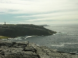
There is no anchorage or shelter and access via the steep rocky cliffs may be difficult, even in calm conditions. There are several natural rock arches and a high cliff on the northern end of the island called Castle Cliff. Various small skerries lie immediately to the north and south. There is very little vegetation save for a few sea-pinks, campion, plantain and orache that can survive the salt spray.Much of the bedrock is Lewisian gneiss
Lewisian complex
The Lewisian complex or Lewisian Gneiss is a suite of Precambrian metamorphic rocks that outcrop in the northwestern part of Scotland, forming part of the Hebridean Terrane. These rocks are of Archaean and Paleoproterozoic age, ranging from 3.0–1.7 Ga. They form the basement on which the...
http://www.geograph.org.uk/photo/734197
History
Skilðar or Skilðir (meaning shields) may have been the Old NorseOld Norse
Old Norse is a North Germanic language that was spoken by inhabitants of Scandinavia and inhabitants of their overseas settlements during the Viking Age, until about 1300....
name for Haskeir. Skildar certainly appears on a map by Nicholas de Nicolay from 1583. There are various theories that somehow the transposition of this name to nearby St Kilda may have created the name for this latter archipelago, whose origins are otherwise obscure.
There is a lighthouse on the island constructed in 1997 and the remains of a bothy, possibly built by fishermen from the Monach Islands
Monach Islands
Not to be confused with Heysker/Hyskeir or HaskeirThe Monach Islands, also known as Heisker , are an island group west of North Uist in the Outer Hebrides of Scotland...
.