
Mid-June 1992 Tornado Outbreak
Encyclopedia
The Mid-June 1992 tornado outbreak was a one of the largest tornado outbreak
s on record, affecting portions of the Central United States
from June 14 to June 18, 1992. The outbreak began on June 14 when six tornadoes touched down in Colorado
and Idaho
. Fifty-eight tornadoes were reported across portions of the Great Plains on June 15, and 65 more were reported over much of the central U.S. on June 16. The 123 tornadoes that touched down on June 15-16 make that two-day span the 5th largest two-day tornado outbreak in U.S. history behind the Super Outbreak
, the May 2004 tornado outbreak sequence, the April 14-16, 2011 tornado outbreak, and the April 25-28, 2011 tornado outbreak. Twenty-eight more tornadoes touched down on June 17, and 13 more touched down on June 18, giving this outbreak 170 confirmed tornadoes.
over the weekend of June 13-14, 1992. The storm ejected a minor upper air impulse across the Northern Plains on June 13, triggering severe weather
across the extreme northwest corner of South Dakota
. Golf ball sized hail and 10 inches of rain destroyed crops and killed over 500 sheep in Harding County, South Dakota
. This event preceded the main storm which still was positioned over the western United States. As the storm moved to the east over the next several days, it caused 170 tornadoes in the central United States, including an F5 tornado in Chandler, Minnesota. The storm system finally began to weaken as it moved to the eastern United States
on June 18.
 On Tuesday, June 16, 1992, eastern South Dakota and southwest Minnesota were heavily impacted by the storm as it moved from the Rocky Mountain Region across the Upper Midwest. At least two dozen tornadoes were reported that day, with more than three times that many reports of large hail and strong winds, causing widespread swaths of damage to crops, buildings, and other personal property across much of eastern South Dakota and southwest Minnesota. The first tornado, spawned by a supercell thunderstorm, touched down in Charles Mix County, South Dakota about 1:00 pm. The last tornado was reported shortly before midnight that evening, ending an 11 hour period of intense severe weather across eastern South Dakota and southwest Minnesota. The 27 tornadoes that touched down in Minnesota on June 16 marks the largest single day tornado outbreak in Minnesota since accurate records started being kept in 1950.
Remarkably there was only one fatality from this outbreak, that coming from an F5
tornado in Chandler, Minnesota
. In addition to the F5, three F4
tornadoes were reported in Murray County, Minnesota
, and Mitchell
and McPherson
counties in Kansas. Damage estimates for the two days were in excess of $160 million dollars.
This outbreak played a large part in a record setting month in June, 1992. The 399 tornadoes that touched down in that month was a United States record at the time, breaking the old record of 335 tornadoes set in May, 1991. This record was eventually broken, when 543 tornadoes touched down
during May, 2003.
 A tornado touched down shortly after 5:00 pm in extreme northwest Nobles County
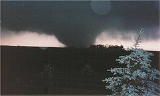
, near Leota. It destroyed a two-house farmstead just east of Leota as it strengthened and moved northeast toward Chandler and Lake Wilson
. The "maxi-tornado" reached its greatest size and strength as it came over the hill immediately south of Chandler, moving into the residential area of west Chandler at approximately 5:18 pm.
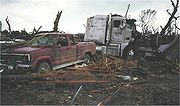
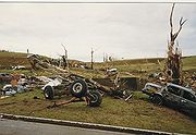
The tornado destroyed more than 75 homes with another 90 homes, 10 businesses, a church and school damaged. It caused over $50 million in property damage, causing one fatality and more than 40 injuries. Based on damage assessment by the National Weather Service
, it is estimated this F5 tornado contained winds in excess of 260 miles per hour (418 km/h) as it moved through the residential area of Chandler. The twister was on the ground for over an hour, traveling approximately 35 miles (56 km) across southwest Minnesota, from northwest Nobles County, through Murray County
, and into southeast Lyon County
. It had a maximum width of 0.75 miles (1.21 km) in the Chandler-Lake Wilson area. This was the only F5 tornado to occur in the United States in 1992.
photograph, document, and experience tornadic supercells firsthand, having reviewed guidance several days in advance. Their target area was southeast South Dakota, but at approximately 330 pm, they entered the northeast periphery of a supercell, eventually running into large hail, still in southwest Minnesota. Without any modern communications (cellular phone or Internet), they decided to backtrack to Boyd, Minnesota. The Clarkfield F3 tornado passed just south of their position. They sought shelter at one of the few brick (assumed at that time to be more resistant of tornado impacts) building in the town, the municipal liquor store. When power failed, a sheriff's deputy who was dispatched there, asked for guidance from the meteorology students. The advice was that they should all seek shelter in the cooler, which was the most central spot in the building, until the tornado passed. Luckily, the tornado passed south of Boyd, although baseball sized hail did occur. (as told by one of the students on this "storm chase", although the term had not yet been coined).
Tornado outbreak
While there is no single agreed upon definition, generally at least 6-10 tornadoes produced by the same synoptic scale weather system is considered a tornado outbreak. The tornadoes usually occur within the same day, or continue into the early morning hours of the succeeding day, and within the...
s on record, affecting portions of the Central United States
Central United States
The Central United States is sometimes conceived as between the Eastern United States and Western United States as part of a three-region model, roughly coincident with the Midwestern United States plus the western and central portions of the Southern United States; the term is also sometimes used...
from June 14 to June 18, 1992. The outbreak began on June 14 when six tornadoes touched down in Colorado
Colorado
Colorado is a U.S. state that encompasses much of the Rocky Mountains as well as the northeastern portion of the Colorado Plateau and the western edge of the Great Plains...
and Idaho
Idaho
Idaho is a state in the Rocky Mountain area of the United States. The state's largest city and capital is Boise. Residents are called "Idahoans". Idaho was admitted to the Union on July 3, 1890, as the 43rd state....
. Fifty-eight tornadoes were reported across portions of the Great Plains on June 15, and 65 more were reported over much of the central U.S. on June 16. The 123 tornadoes that touched down on June 15-16 make that two-day span the 5th largest two-day tornado outbreak in U.S. history behind the Super Outbreak
Super Outbreak
The Super Outbreak is the second largest tornado outbreak on record for a single 24-hour period, just behind the tornado outbreak of April 25–28, 2011...
, the May 2004 tornado outbreak sequence, the April 14-16, 2011 tornado outbreak, and the April 25-28, 2011 tornado outbreak. Twenty-eight more tornadoes touched down on June 17, and 13 more touched down on June 18, giving this outbreak 170 confirmed tornadoes.
Meteorological synopsis
A major spring storm began developing in the western United StatesWestern United States
.The Western United States, commonly referred to as the American West or simply "the West," traditionally refers to the region comprising the westernmost states of the United States. Because the U.S. expanded westward after its founding, the meaning of the West has evolved over time...
over the weekend of June 13-14, 1992. The storm ejected a minor upper air impulse across the Northern Plains on June 13, triggering severe weather
Severe weather
Severe weather phenomena are weather conditions that are hazardous to human life and property.- Examples Include :Severe weather can occur under a variety of situations, but three characteristics are generally needed: a temperature or moisture boundary, moisture, and , instability in the...
across the extreme northwest corner of South Dakota
South Dakota
South Dakota is a state located in the Midwestern region of the United States. It is named after the Lakota and Dakota Sioux American Indian tribes. Once a part of Dakota Territory, South Dakota became a state on November 2, 1889. The state has an area of and an estimated population of just over...
. Golf ball sized hail and 10 inches of rain destroyed crops and killed over 500 sheep in Harding County, South Dakota
Harding County, South Dakota
As of the census of 2000, there were 1,353 people, 525 households, and 352 families residing in the county. The population density was 0.5 people per square mile . There were 804 housing units at an average density of 0.3 per square mile...
. This event preceded the main storm which still was positioned over the western United States. As the storm moved to the east over the next several days, it caused 170 tornadoes in the central United States, including an F5 tornado in Chandler, Minnesota. The storm system finally began to weaken as it moved to the eastern United States
Eastern United States
The Eastern United States, the American East, or simply the East is traditionally defined as the states east of the Mississippi River. The first two tiers of states west of the Mississippi have traditionally been considered part of the West, but can be included in the East today; usually in...
on June 18.
Outbreak description
Remarkably there was only one fatality from this outbreak, that coming from an F5
Fujita scale
The Fujita scale , or Fujita-Pearson scale, is a scale for rating tornado intensity, based primarily on the damage tornadoes inflict on human-built structures and vegetation...
tornado in Chandler, Minnesota
Chandler, Minnesota
As of the census of 2000, there were 276 people, 113 households, and 72 families residing in the city. The population density was 342.7 people per square mile . There were 121 housing units at an average density of 150.2 per square mile . The racial makeup of the city was 97.46% White, 1.81%...
. In addition to the F5, three F4
Fujita scale
The Fujita scale , or Fujita-Pearson scale, is a scale for rating tornado intensity, based primarily on the damage tornadoes inflict on human-built structures and vegetation...
tornadoes were reported in Murray County, Minnesota
Murray County, Minnesota
As of the census of 2000, there were 9,165 people, 3,722 households, and 2,601 families residing in the county. The population density was 13 people per square mile . There were 4,357 housing units at an average density of 6 per square mile...
, and Mitchell
Mitchell County, Kansas
Mitchell County is a county located in the U.S. state of Kansas. As of the 2010 census, the county population was 6,373...
and McPherson
McPherson County, Kansas
McPherson County is a county located in the U.S. state of Kansas. As of the 2010 census, the county population was 29,180. The largest city and county seat is McPherson. The county is named for Civil War General James B. McPherson...
counties in Kansas. Damage estimates for the two days were in excess of $160 million dollars.
This outbreak played a large part in a record setting month in June, 1992. The 399 tornadoes that touched down in that month was a United States record at the time, breaking the old record of 335 tornadoes set in May, 1991. This record was eventually broken, when 543 tornadoes touched down
May 2003 tornado outbreak sequence
The May 2003 tornado outbreak sequence in the United States was a series of tornado outbreaks that occurred from May 3 to May 11, 2003. Tornadoes began occurring over the affected area on April 30, but the most prolific continuous period was the seven day period of May 4–10...
during May, 2003.
Chandler – Lake Wilson tornado
Nobles County, Minnesota
Nobles County is a county located in the U.S. state of Minnesota. As of 2010, the population was 21,378. Its county seat is Worthington.-Geography:...
, near Leota. It destroyed a two-house farmstead just east of Leota as it strengthened and moved northeast toward Chandler and Lake Wilson
Lake Wilson, Minnesota
As of the census of 2000, there were 270 people, 128 households, and 83 families residing in the city. The population density was 650.1 people per square mile . There were 135 housing units at an average density of 325.0 per square mile . The racial makeup of the city was 98.89% White, 0.37%...
. The "maxi-tornado" reached its greatest size and strength as it came over the hill immediately south of Chandler, moving into the residential area of west Chandler at approximately 5:18 pm.
The tornado destroyed more than 75 homes with another 90 homes, 10 businesses, a church and school damaged. It caused over $50 million in property damage, causing one fatality and more than 40 injuries. Based on damage assessment by the National Weather Service
National Weather Service
The National Weather Service , once known as the Weather Bureau, is one of the six scientific agencies that make up the National Oceanic and Atmospheric Administration of the United States government...
, it is estimated this F5 tornado contained winds in excess of 260 miles per hour (418 km/h) as it moved through the residential area of Chandler. The twister was on the ground for over an hour, traveling approximately 35 miles (56 km) across southwest Minnesota, from northwest Nobles County, through Murray County
Murray County, Minnesota
As of the census of 2000, there were 9,165 people, 3,722 households, and 2,601 families residing in the county. The population density was 13 people per square mile . There were 4,357 housing units at an average density of 6 per square mile...
, and into southeast Lyon County
Lyon County, Minnesota
As of the census of 2000, there were 25,425 people, 9,715 households, and 6,334 families residing in the county. The population density was 36 people per square mile . There were 10,298 housing units at an average density of 14 per square mile...
. It had a maximum width of 0.75 miles (1.21 km) in the Chandler-Lake Wilson area. This was the only F5 tornado to occur in the United States in 1992.
Non-tornadic events
In addition to the severe weather, another devastating weather event was taking place across northeastern South Dakota. Heavy rains were occurring in an area already saturated by previous rains. Over a two to three day period in mid-June 1992, 15 to 20 inches of rain fell in the Clear Lake-Watertown area of northeast South Dakota, resulting in widespread flooding throughout the area, and major downstream flooding of the Big Sioux River.A brief description of that day from two meteorology students
On June 16th, two students from the St. Cloud State meteorology department, sensing that the environment was ripe for tornadoes, and against the advice of their professors, sought tophotograph, document, and experience tornadic supercells firsthand, having reviewed guidance several days in advance. Their target area was southeast South Dakota, but at approximately 330 pm, they entered the northeast periphery of a supercell, eventually running into large hail, still in southwest Minnesota. Without any modern communications (cellular phone or Internet), they decided to backtrack to Boyd, Minnesota. The Clarkfield F3 tornado passed just south of their position. They sought shelter at one of the few brick (assumed at that time to be more resistant of tornado impacts) building in the town, the municipal liquor store. When power failed, a sheriff's deputy who was dispatched there, asked for guidance from the meteorology students. The advice was that they should all seek shelter in the cooler, which was the most central spot in the building, until the tornado passed. Luckily, the tornado passed south of Boyd, although baseball sized hail did occur. (as told by one of the students on this "storm chase", although the term had not yet been coined).
June 14
| List of confirmed tornadoes | ||||||
|---|---|---|---|---|---|---|
Fujita scale The Fujita scale , or Fujita-Pearson scale, is a scale for rating tornado intensity, based primarily on the damage tornadoes inflict on human-built structures and vegetation... |
|
|
|
|
|
|
| Idaho Idaho Idaho is a state in the Rocky Mountain area of the United States. The state's largest city and capital is Boise. Residents are called "Idahoans". Idaho was admitted to the Union on July 3, 1890, as the 43rd state.... |
||||||
| F0 | E of Burley Burley, Idaho Burley is a city in Cassia and Minidoka counties in the southern portion of the U.S. state of Idaho. The population was 10,345 at the 2010 census. The city is the county seat of Cassia County.... |
Cassia Cassia County, Idaho Cassia County is a county located in the U.S. state of Idaho. As of the 2010 Census the county had a population of 22,952. The county seat and largest city is Burley.-History:... |
2202 | 0 miles | ||
| Colorado Colorado Colorado is a U.S. state that encompasses much of the Rocky Mountains as well as the northeastern portion of the Colorado Plateau and the western edge of the Great Plains... |
||||||
| F0 | W of Gill Gill, Colorado Gill is an unincorporated town and a U.S. Post Office in Weld County, Colorado, United States. The Gill Post Office has the ZIP Code 80624.... |
Weld Weld County, Colorado As of the census of 2000, there were 180,936 people, 63,247 households, and 45,221 families residing in the county. The population density was 45 people per square mile . There were 66,194 housing units at an average density of 17 per square mile... |
0026 | 1 miles (1.6 km) | ||
| F0 | N of Goodrich | Morgan Morgan County, Colorado Morgan County is the 18th most populous of the 64 counties of the State of Colorado of the United States. The county was named after old Fort Morgan, which in turn was named in honor of Colonel Christopher A. Morgan. The county population was 27,171 at U.S. Census 2000. The county seat is the... |
0027 | 0 miles | ||
| F0 | SE of Raymer Raymer, Colorado The Town of Raymer is a Statutory Town located in Weld County, Colorado, United States. The population was 91 at the U.S. Census 2000.The community has two official names:*Raymer - The legal name of the incorporated Town of Raymer.... |
Morgan Morgan County, Colorado Morgan County is the 18th most populous of the 64 counties of the State of Colorado of the United States. The county was named after old Fort Morgan, which in turn was named in honor of Colonel Christopher A. Morgan. The county population was 27,171 at U.S. Census 2000. The county seat is the... |
0027 | 0 miles | ||
| F0 | NE of Barnesville | Weld Weld County, Colorado As of the census of 2000, there were 180,936 people, 63,247 households, and 45,221 families residing in the county. The population density was 45 people per square mile . There were 66,194 housing units at an average density of 17 per square mile... |
0115 | 0 miles | ||
| F0 | N of Fort Morgan Fort Morgan, Colorado The City of Fort Morgan is a Home Rule Municipality that is the county seat and the most populous city of Morgan County, Colorado, United States. The United States Census Bureau estimated that the city population was 10,844 in 2005.-History:... |
Weld Weld County, Colorado As of the census of 2000, there were 180,936 people, 63,247 households, and 45,221 families residing in the county. The population density was 45 people per square mile . There were 66,194 housing units at an average density of 17 per square mile... |
0130 | 0 miles | ||
June 15 event
| List of confirmed tornadoes | ||||||
|---|---|---|---|---|---|---|
Fujita scale The Fujita scale , or Fujita-Pearson scale, is a scale for rating tornado intensity, based primarily on the damage tornadoes inflict on human-built structures and vegetation... |
|
|
|
|
|
|
| Kansas Kansas Kansas is a US state located in the Midwestern United States. It is named after the Kansas River which flows through it, which in turn was named after the Kansa Native American tribe, which inhabited the area. The tribe's name is often said to mean "people of the wind" or "people of the south... |
||||||
| F0 | NE of Plainville Plainville, Kansas Plainville is a city in Rooks County, Kansas, United States. As of the 2010 census, the city population was 1,903.-19th century:The area was first settled in 1877 by Hiram Keas. Plainville, previously known as Paradise Flats, was established in 1888, in Rooks County, Kansas... (1st tornado) |
Rooks Rooks County, Kansas Rooks County is a county located in the U.S. state of Kansas. As of the 2010 census, the county population was 5,181. The county seat is Stockton and the largest city is Plainville. The county was named for Private John C... |
2115 | 1 miles (1.6 km) | ||
| F1 | N of Natoma Natoma, Kansas Natoma is a city in Osborne County, Kansas, United States. As of the 2010 census, the city population was 335.-History:Natoma was established in 1888, named after an American Indian railroad employee by a railroad officer. The name means "new born." The first post office had opened under the name... (1st tornado) |
Osborne Osborne County, Kansas Osborne County is a county located in the U.S. state of Kansas. As of the 2010 census, the county population was 3,858. The largest city and county seat is Osborne.-19th century:... |
2126 | 1 miles (1.6 km) | ||
| F0 | E of Zurich Zurich, Kansas Zurich is a city in Rooks County, Kansas, United States. As of the 2010 census, the city population was 99.-Geography:Zurich is located at . According to the United States Census Bureau, the city has a total area of , all of it land.... |
Rooks Rooks County, Kansas Rooks County is a county located in the U.S. state of Kansas. As of the 2010 census, the county population was 5,181. The county seat is Stockton and the largest city is Plainville. The county was named for Private John C... |
2128 | 1 miles (1.6 km) | ||
| F1 | NE of Plainville Plainville, Kansas Plainville is a city in Rooks County, Kansas, United States. As of the 2010 census, the city population was 1,903.-19th century:The area was first settled in 1877 by Hiram Keas. Plainville, previously known as Paradise Flats, was established in 1888, in Rooks County, Kansas... (2nd tornado |
Rooks Rooks County, Kansas Rooks County is a county located in the U.S. state of Kansas. As of the 2010 census, the county population was 5,181. The county seat is Stockton and the largest city is Plainville. The county was named for Private John C... |
2137 | 7 miles (11.2 km) | ||
| F0 | N of Natona (2nd tornado) | Osborne Osborne County, Kansas Osborne County is a county located in the U.S. state of Kansas. As of the 2010 census, the county population was 3,858. The largest city and county seat is Osborne.-19th century:... |
2146 | 0.5 miles (0.8 km) | ||
| F0 | SE of Bloomington (1st tornado) | Osborne Osborne County, Kansas Osborne County is a county located in the U.S. state of Kansas. As of the 2010 census, the county population was 3,858. The largest city and county seat is Osborne.-19th century:... |
2251 | 0.5 miles (0.8 km) | ||
| F1 | SE of Bloomington (2nd tornado) | Osborne Osborne County, Kansas Osborne County is a county located in the U.S. state of Kansas. As of the 2010 census, the county population was 3,858. The largest city and county seat is Osborne.-19th century:... |
2251 | 2 miles (3.2 km) | ||
| F1 | SE of Osborne Osborne, Kansas Osborne is a city in and the county seat of Osborne County, Kansas, United States. As of the 2010 census, the city population was 1,431.-History:... (1st tornado) |
Osborne Osborne County, Kansas Osborne County is a county located in the U.S. state of Kansas. As of the 2010 census, the county population was 3,858. The largest city and county seat is Osborne.-19th century:... |
2315 | 0.8 miles (1.3 km) | ||
| F1 | SW of Osborne Osborne, Kansas Osborne is a city in and the county seat of Osborne County, Kansas, United States. As of the 2010 census, the city population was 1,431.-History:... |
Osborne Osborne County, Kansas Osborne County is a county located in the U.S. state of Kansas. As of the 2010 census, the county population was 3,858. The largest city and county seat is Osborne.-19th century:... |
2334 | 1 miles (1.6 km) | ||
| F1 | S of Osborne Osborne, Kansas Osborne is a city in and the county seat of Osborne County, Kansas, United States. As of the 2010 census, the city population was 1,431.-History:... |
Osborne Osborne County, Kansas Osborne County is a county located in the U.S. state of Kansas. As of the 2010 census, the county population was 3,858. The largest city and county seat is Osborne.-19th century:... |
2340 | 1 miles (1.6 km) | ||
| F1 | Osborne Osborne, Kansas Osborne is a city in and the county seat of Osborne County, Kansas, United States. As of the 2010 census, the city population was 1,431.-History:... area |
Osborne Osborne County, Kansas Osborne County is a county located in the U.S. state of Kansas. As of the 2010 census, the county population was 3,858. The largest city and county seat is Osborne.-19th century:... |
2345 | 0.5 miles (0.8 km) | ||
| F1 | SE of Osborne Osborne, Kansas Osborne is a city in and the county seat of Osborne County, Kansas, United States. As of the 2010 census, the city population was 1,431.-History:... (2nd tornado) |
Osborne Osborne County, Kansas Osborne County is a county located in the U.S. state of Kansas. As of the 2010 census, the county population was 3,858. The largest city and county seat is Osborne.-19th century:... |
2355 | 1 miles (1.6 km) | ||
| F2 | SE of Corinth | Mitchell Mitchell County, Kansas Mitchell County is a county located in the U.S. state of Kansas. As of the 2010 census, the county population was 6,373... |
2356 | 3.5 miles (5.6 km) | ||
| F1 | SE of Mankato Mankato, Kansas Mankato is a city in and the county seat of Jewell County, Kansas, United States. As of the 2010 census, the city population was 869.-Geography:Mankato is located at... |
Jewell Jewell County, Kansas Jewell County is a county located in North Central Kansas, in the Central United States. As of the 2010 census, the county population was 3,077. Its county seat and most populous city is Mankato.-19th century:... |
2359 | 1 miles (1.6 km) | ||
| F2 | NE of Tipton Tipton, Kansas Tipton is a city in Mitchell County, Kansas, United States. As of the 2010 census, the city population was 210.-Geography:Tipton is located at . According to the United States Census Bureau, the city has a total area of , all of it land.-Demographics:As of the census of 2000, there were 243... (1st tornado) |
Mitchell Mitchell County, Kansas Mitchell County is a county located in the U.S. state of Kansas. As of the 2010 census, the county population was 6,373... |
0002 | 3 miles (4.8 km) | ||
| F1 | SW of Webber Webber, Kansas Webber is a city in Jewell County, Kansas, United States. As of the 2010 census, the city population was 25.-History:In 1887, Atchison, Topeka and Santa Fe Railway built a branch line from Neva through Webber to Superior, Nebraska... |
Jewell Jewell County, Kansas Jewell County is a county located in North Central Kansas, in the Central United States. As of the 2010 census, the county population was 3,077. Its county seat and most populous city is Mankato.-19th century:... |
0006 | 2 miles (3.2 km) | ||
| F1 | NE of Tipton Tipton, Kansas Tipton is a city in Mitchell County, Kansas, United States. As of the 2010 census, the city population was 210.-Geography:Tipton is located at . According to the United States Census Bureau, the city has a total area of , all of it land.-Demographics:As of the census of 2000, there were 243... (2nd tornado) |
Mitchell Mitchell County, Kansas Mitchell County is a county located in the U.S. state of Kansas. As of the 2010 census, the county population was 6,373... |
0007 | 1.5 miles (2.4 km) | ||
| F2 | E of Mankato Mankato, Kansas Mankato is a city in and the county seat of Jewell County, Kansas, United States. As of the 2010 census, the city population was 869.-Geography:Mankato is located at... |
Jewell Jewell County, Kansas Jewell County is a county located in North Central Kansas, in the Central United States. As of the 2010 census, the county population was 3,077. Its county seat and most populous city is Mankato.-19th century:... |
0009 | 1.5 miles (2.4 km) | ||
| F2 | E of Tipton Tipton, Kansas Tipton is a city in Mitchell County, Kansas, United States. As of the 2010 census, the city population was 210.-Geography:Tipton is located at . According to the United States Census Bureau, the city has a total area of , all of it land.-Demographics:As of the census of 2000, there were 243... |
Mitchell Mitchell County, Kansas Mitchell County is a county located in the U.S. state of Kansas. As of the 2010 census, the county population was 6,373... |
0010 | 4 miles (6.4 km) | ||
| F4 | SW of Beloit Beloit, Kansas Beloit is a city in and the county seat of Mitchell County, Kansas, United States. As of the 2010 census, the city population was 3,835.- History :... (1st tornado) |
Mitchell Mitchell County, Kansas Mitchell County is a county located in the U.S. state of Kansas. As of the 2010 census, the county population was 6,373... |
0030 | 3 miles (4.8 km) | ||
| F1 | NW of Lovewell | Jewell Jewell County, Kansas Jewell County is a county located in North Central Kansas, in the Central United States. As of the 2010 census, the county population was 3,077. Its county seat and most populous city is Mankato.-19th century:... |
0035 | 1.5 miles (2.4 km) | ||
| F2 | SW of Beloit Beloit, Kansas Beloit is a city in and the county seat of Mitchell County, Kansas, United States. As of the 2010 census, the city population was 3,835.- History :... (2nd tornado) |
Mitchell Mitchell County, Kansas Mitchell County is a county located in the U.S. state of Kansas. As of the 2010 census, the county population was 6,373... |
0035 | 2 miles (3.2 km) | ||
| F2 | SW of Beloit Beloit, Kansas Beloit is a city in and the county seat of Mitchell County, Kansas, United States. As of the 2010 census, the city population was 3,835.- History :... (3rd tornado) |
Mitchell Mitchell County, Kansas Mitchell County is a county located in the U.S. state of Kansas. As of the 2010 census, the county population was 6,373... |
0038 | 2 miles (3.2 km) | ||
| F1 | SW of Beloit Beloit, Kansas Beloit is a city in and the county seat of Mitchell County, Kansas, United States. As of the 2010 census, the city population was 3,835.- History :... (4th tornado) |
Mitchell Mitchell County, Kansas Mitchell County is a county located in the U.S. state of Kansas. As of the 2010 census, the county population was 6,373... |
0040 | 2 miles (3.2 km) | ||
| F3 | SW of Beloit Beloit, Kansas Beloit is a city in and the county seat of Mitchell County, Kansas, United States. As of the 2010 census, the city population was 3,835.- History :... (5th tornado) |
Mitchell Mitchell County, Kansas Mitchell County is a county located in the U.S. state of Kansas. As of the 2010 census, the county population was 6,373... |
0045 | 2 miles (3.2 km) | ||
| F1 | SW of Beloit Beloit, Kansas Beloit is a city in and the county seat of Mitchell County, Kansas, United States. As of the 2010 census, the city population was 3,835.- History :... (6th tornado) |
Mitchell Mitchell County, Kansas Mitchell County is a county located in the U.S. state of Kansas. As of the 2010 census, the county population was 6,373... |
0055 | 1.5 miles (2.4 km) | ||
| F0 | N of Republic Republic, Kansas Republic is a city in Republic County, Kansas, United States. As of the 2010 census, the city population was 116.-Geography:Republic is located at . According to the United States Census Bureau, the city has a total area of , all of it land.-Demographics:As of the census of 2000, there were 161... |
Republic Republic County, Kansas Republic County is a county located in the state of Kansas. As of the 2010 census, the county population was 4,980. The largest city and county seat is Belleville.-19th century:... |
0100 | 0.5 miles (0.8 km) | ||
| F1 | SW of Beloit Beloit, Kansas Beloit is a city in and the county seat of Mitchell County, Kansas, United States. As of the 2010 census, the city population was 3,835.- History :... (7th tornado) |
Mitchell Mitchell County, Kansas Mitchell County is a county located in the U.S. state of Kansas. As of the 2010 census, the county population was 6,373... |
0105 | 1.3 miles (2.1 km) | ||
| F1 | SW of Simpson Simpson, Kansas Simpson is a city in Cloud and Mitchell counties in Kansas, United States. As of the 2010 census, the city population was 86.-Geography:Simpson is located at... |
Mitchell Mitchell County, Kansas Mitchell County is a county located in the U.S. state of Kansas. As of the 2010 census, the county population was 6,373... |
0135 | 2 miles (3.2 km) | ||
| F1 | SE of Simpson Simpson, Kansas Simpson is a city in Cloud and Mitchell counties in Kansas, United States. As of the 2010 census, the city population was 86.-Geography:Simpson is located at... |
Cloud Cloud County, Kansas Cloud County is a county located in North Central Kansas, in the Central United States. As of the 2010 census, the county population was 9,533. Its county seat and most populous city is Concordia.-19th century:... |
0152 | 2 miles (3.2 km) | ||
| F1 | NE of Simpson Simpson, Kansas Simpson is a city in Cloud and Mitchell counties in Kansas, United States. As of the 2010 census, the city population was 86.-Geography:Simpson is located at... |
Cloud Cloud County, Kansas Cloud County is a county located in North Central Kansas, in the Central United States. As of the 2010 census, the county population was 9,533. Its county seat and most populous city is Concordia.-19th century:... |
0158 | 2 miles (3.2 km) | ||
| F1 | S of Delphos Delphos, Kansas Delphos is a city in Ottawa County, Kansas, United States. As of the 2010 census, the city population was 359. It is part of the Salina Micropolitan Statistical Area. The community was named after Delphos, Ohio.-Geography:... |
Ottawa Ottawa County, Kansas Ottawa County is a county located in the U.S. state of Kansas. As of the 2010 census, the county population was 6,091. The largest city and county seat is Minneapolis... |
0235 | 1 miles (1.6 km) | ||
| F3 | W of Delphos Delphos, Kansas Delphos is a city in Ottawa County, Kansas, United States. As of the 2010 census, the city population was 359. It is part of the Salina Micropolitan Statistical Area. The community was named after Delphos, Ohio.-Geography:... |
Ottawa Ottawa County, Kansas Ottawa County is a county located in the U.S. state of Kansas. As of the 2010 census, the county population was 6,091. The largest city and county seat is Minneapolis... |
0252 | 3 miles (4.8 km) | ||
| F4 | McPherson McPherson, Kansas McPherson is a city in and the county seat of McPherson County, Kansas, United States, in the central part of the state. As of the 2010 census, the city population was 13,155. The city is named after Union General James Birdseye McPherson, a Civil War general... area |
McPherson McPherson County, Kansas McPherson County is a county located in the U.S. state of Kansas. As of the 2010 census, the county population was 29,180. The largest city and county seat is McPherson. The county is named for Civil War General James B. McPherson... |
0335 | 6 miles (9.6 km) | ||
| F1 | NW of Miltonvale Miltonvale, Kansas Miltonvale is a city in Cloud County, Kansas, United States. As of the 2010 census, the city population was 539.-History:Miltonvale was founded on December 1, 1881.From 1909 to 1972, it was the home of Miltonvale Wesleyan College.... |
Cloud Cloud County, Kansas Cloud County is a county located in North Central Kansas, in the Central United States. As of the 2010 census, the county population was 9,533. Its county seat and most populous city is Concordia.-19th century:... |
0337 | 1 miles (1.6 km) | ||
| F2 | Roxbury Roxbury, Kansas Roxbury is an unincorporated community about 14.8 miles east of Lindsborg in McPherson County, Kansas, United States. The population was 100 at the 1910 census. The original name for the area was Colfax City but the name was changed to Roxbury on March 4, 1875 due to an act of... area |
McPherson McPherson County, Kansas McPherson County is a county located in the U.S. state of Kansas. As of the 2010 census, the county population was 29,180. The largest city and county seat is McPherson. The county is named for Civil War General James B. McPherson... |
0340 | 7 miles (11.2 km) | ||
| F1 | SE of Roxbury Roxbury, Kansas Roxbury is an unincorporated community about 14.8 miles east of Lindsborg in McPherson County, Kansas, United States. The population was 100 at the 1910 census. The original name for the area was Colfax City but the name was changed to Roxbury on March 4, 1875 due to an act of... to NW of Ramona Ramona, Kansas Ramona is a city in Marion County, Kansas, United States. As of the 2010 census, the city population was 187.-19th century:For millennia, the land that is currently Kansas was inhabited by Native Americans. The city name is a spanish name. Land ownership of the Ramona area dates back when the... |
McPherson McPherson County, Kansas McPherson County is a county located in the U.S. state of Kansas. As of the 2010 census, the county population was 29,180. The largest city and county seat is McPherson. The county is named for Civil War General James B. McPherson... , Marion Marion County, Kansas Marion County is a county located in the U.S. state of Kansas. As of the 2010 census, the county population was 12,660. The county seat is Marion... |
0509 | 17 miles (27.2 km) | ||
| F1 | SW of Elmo Elmo, Kansas Elmo is a small unincorporated community in Dickinson County, Kansas, United States. The post office was established December 16, 1884, and discontinued May 6, 1966. The well-known Elmo fossil insect bed is southeast of town.-External links:*... |
Dickinson Dickinson County, Kansas Dickinson County is a county located in Central Kansas, in the Central United States. As of the 2010 census, the county population was 19,754. Its county seat and most populous city is Abilene. It was named in honor of Daniel S. Dickinson.-19th century:In 1887, Mr. Herington successfully got... |
0520 | 2 miles (3.2 km) | ||
| F0 | SW of Abilene Abilene, Kansas Abilene is a city in and the county seat of Dickinson County, Kansas, United States. As of the 2010 census, the city population was 6,844.-History:... |
Dickinson Dickinson County, Kansas Dickinson County is a county located in Central Kansas, in the Central United States. As of the 2010 census, the county population was 19,754. Its county seat and most populous city is Abilene. It was named in honor of Daniel S. Dickinson.-19th century:In 1887, Mr. Herington successfully got... |
0538 | 0.1 miles (0.16 km) | ||
| F1 | E of Enterprise Enterprise, Kansas Enterprise is a city in Dickinson County, Kansas, United States. As of the 2010 census, the city population was 855.-History:On January 10, 1883, the Enterprise Town Company, capital $50,000, was organized. The following officers were elected: V. P. Wilson, president; John Johntz, vice-president;... |
Dickinson Dickinson County, Kansas Dickinson County is a county located in Central Kansas, in the Central United States. As of the 2010 census, the county population was 19,754. Its county seat and most populous city is Abilene. It was named in honor of Daniel S. Dickinson.-19th century:In 1887, Mr. Herington successfully got... |
0648 | 1 miles (1.6 km) | ||
| F0 | S of Solomon Solomon, Kansas Solomon is a city in Dickinson and Saline counties in the U.S. state of Kansas. As of the 2010 census, the city population was 1,095. The Saline County portion of Solomon is part of the Salina Micropolitan Statistical Area.-Geography:... |
Dickinson Dickinson County, Kansas Dickinson County is a county located in Central Kansas, in the Central United States. As of the 2010 census, the county population was 19,754. Its county seat and most populous city is Abilene. It was named in honor of Daniel S. Dickinson.-19th century:In 1887, Mr. Herington successfully got... |
0705 | 1.5 miles (2.4 km) | ||
| South Dakota South Dakota South Dakota is a state located in the Midwestern region of the United States. It is named after the Lakota and Dakota Sioux American Indian tribes. Once a part of Dakota Territory, South Dakota became a state on November 2, 1889. The state has an area of and an estimated population of just over... |
||||||
| F2 | S of Philip Philip, South Dakota Philip is a city in Haakon County, South Dakota, United States. The population was 779 at the 2010 census. It is the county seat of Haakon County.-Geography:Philip is located at .... |
Haakon Haakon County, South Dakota As of the census of 2000, there were 2,196 people, 870 households, and 620 families residing in the county. The population density was 1 person per square mile . There were 1,002 housing units at an average density of 1 per square mile . The racial makeup of the county was 96.40% White,... |
2210 | 2 miles (3.2 km) | ||
| F0 | NE of Raymond Raymond, South Dakota Raymond is a town in Clark County, South Dakota, United States. The population was 50 at the 2010 census.-Geography:Raymond is located at .According to the United States Census Bureau, the town has a total area of , all of it land.... |
Clark Clark County, South Dakota As of the census of 2000, there were 4,143 people, 1,598 households, and 1,110 families residing in the county. The population density was 4 people per square mile . There were 1,880 housing units at an average density of 2 per square mile... |
0005 | 0.2 miles (0.32 km) | ||
| F0 | SE of Bristol Bristol, South Dakota Bristol is a city located in western Day County, South Dakota, United States. It lies in Section 25 of Bristol Township, on the main line of what is now the BNSF Railway alongside U.S. Route 12.... |
Day Day County, South Dakota As of the census of 2000, there were 6,267 people, 2,586 households, and 1,688 families residing in the county. The population density was 6 people per square mile . There were 3,618 housing units at an average density of 4 per square mile... |
0250 | 0.5 miles (0.8 km) | ||
| Nebraska Nebraska Nebraska is a state on the Great Plains of the Midwestern United States. The state's capital is Lincoln and its largest city is Omaha, on the Missouri River.... |
||||||
| F1 | Doniphan Doniphan, Nebraska Doniphan is a village in Hall County, Nebraska, United States. The population was 763 at the 2000 census. It is part of the Grand Island, Nebraska Micropolitan Statistical Area. The town of Doniphan was platted by local pioneer William J. Burger in 1879 as a midway point between Hastings and Grand... area |
Hall Hall County, Nebraska -History:Hall County was formed in 1858. It was named after Augustus Hall, an early judge of this territory.- Demographics :As of the census of 2000, there were 53,534 people, 20,356 households, and 14,086 families residing in the county. The population density was 98 people per square mile... |
0020 | 0.1 miles (0.16 km) | ||
| F2 | SW of Osceola Osceola, Nebraska -Demographics:As of the census of 2000, there were 921 people, 381 households, and 235 families residing in the city. The population density was 1,036.8 people per square mile . There were 417 housing units at an average density of 469.4 per square mile . The racial makeup of the city was 99.57%... |
Polk Polk County, Nebraska -Demographics:As of the census of 2000, there were 5,639 people, 2,259 households, and 1,570 families residing in the county. The population density was 5/km² . There were 2,717 housing units at an average density of 2/km²... |
0045 | 2 miles (3.2 km) | ||
| F2 | N of Hampton Hampton, Nebraska Hampton is a village in Hamilton County, Nebraska, USA. The population was 439 at the 2000 census.-Geography:Hampton is located at .According to the United States Census Bureau, the village has a total area of , all of it land.... |
Hamilton Hamilton County, Nebraska -Demographics:As of the census of 2000, there were 9,403 people, 3,503 households, and 2,676 families residing in the county. The population density was 17 people per square mile . There were 3,850 housing units at an average density of 7 per square mile... |
0055 | 0.1 miles (0.16 km) | ||
| F0 | N of Schuyler Schuyler, Nebraska Schuyler is a city in Colfax County, Nebraska, United States. The population was 5,371 at the 2000 census. It is the county seat of Colfax County. The city is named after former Vice President of the United States, Schuyler Colfax... (1st tornado) |
Colfax Colfax County, Nebraska -Demographics:As of the census of 2000, there were 10,441 people, 3,682 households, and 2,592 families residing in the county. The population density was 25 people per square mile . There were 4,088 housing units at an average density of 10 per square mile... |
0115 | 0.1 miles (0.16 km) | ||
| F2 | N of Schuyler Schuyler, Nebraska Schuyler is a city in Colfax County, Nebraska, United States. The population was 5,371 at the 2000 census. It is the county seat of Colfax County. The city is named after former Vice President of the United States, Schuyler Colfax... (2nd tornado) |
Colfax Colfax County, Nebraska -Demographics:As of the census of 2000, there were 10,441 people, 3,682 households, and 2,592 families residing in the county. The population density was 25 people per square mile . There were 4,088 housing units at an average density of 10 per square mile... |
0115 | 0.1 miles (0.16 km) | ||
| F3 | SE of Milligan Milligan, Nebraska Milligan is a village in Fillmore County, Nebraska, United States. The population was 285 at the 2010 census.-Geography:Milligan is located at .... to W of Milford Milford, Nebraska Milford is a city in Seward County, Nebraska, United States. It is part of the Lincoln, Nebraska Metropolitan Statistical Area. The population was 2,070 at the 2000 census.-Geography:Milford is located at .... |
Saline Saline County, Nebraska -Demographics:As of the census of 2000, there were 13,843 people, 5,188 households, and 3,507 families residing in the county. The population density was 24 people per square mile . There were 5,611 housing units at an average density of 10 per square mile... , Seward Seward County, Nebraska -Demographics:As of the census of 2000, there were 16,496 people, 6,013 households, and 4,215 families residing in the county. The population density was 29 people per square mile . There were 6,428 housing units at an average density of 11 per square mile... |
0155 | 21 miles (33.6 km) | ||
| F1 | W of West Point West Point, Nebraska West Point is a city in and the county seat of Cuming County, Nebraska, United States. The population was 3,660 at the 2000 census.-History:West Point was first founded in the spring of 1857, when Omaha businessmen formed the Nebraska Settlement Association in order to find suitable townsites in... |
Cuming Cuming County, Nebraska -History:Cuming County was formed in 1855. It was named after Thomas B. Cuming, an early governor of this territory.-Demographics:As of the census of 2000, there were 10,203 people, 3,945 households, and 2,757 families residing in the county. The population density was 18 people per square mile... |
0250 | 0.5 miles (0.8 km) | ||
| F1 | SW of West Point West Point, Nebraska West Point is a city in and the county seat of Cuming County, Nebraska, United States. The population was 3,660 at the 2000 census.-History:West Point was first founded in the spring of 1857, when Omaha businessmen formed the Nebraska Settlement Association in order to find suitable townsites in... |
Cuming Cuming County, Nebraska -History:Cuming County was formed in 1855. It was named after Thomas B. Cuming, an early governor of this territory.-Demographics:As of the census of 2000, there were 10,203 people, 3,945 households, and 2,757 families residing in the county. The population density was 18 people per square mile... |
0255 | 0.5 miles (0.8 km) | ||
| F1 | SE of West Point West Point, Nebraska West Point is a city in and the county seat of Cuming County, Nebraska, United States. The population was 3,660 at the 2000 census.-History:West Point was first founded in the spring of 1857, when Omaha businessmen formed the Nebraska Settlement Association in order to find suitable townsites in... |
Cuming Cuming County, Nebraska -History:Cuming County was formed in 1855. It was named after Thomas B. Cuming, an early governor of this territory.-Demographics:As of the census of 2000, there were 10,203 people, 3,945 households, and 2,757 families residing in the county. The population density was 18 people per square mile... |
0300 | 4 miles (6.4 km) | ||
| F3 | W of Malcolm Malcolm, Nebraska Malcolm is a village in Lancaster County, Nebraska, United States. It is part of the Lincoln, Nebraska Metropolitan Statistical Area. The population was 413 at the 2000 census.-Geography:Malcolm is located at .... |
Seward Seward County, Nebraska -Demographics:As of the census of 2000, there were 16,496 people, 6,013 households, and 4,215 families residing in the county. The population density was 29 people per square mile . There were 6,428 housing units at an average density of 11 per square mile... |
0315 | 14 miles (22.4 km) | ||
| F1 | N of Bancroft Bancroft, Nebraska Bancroft is a village in Cuming County, Nebraska, United States. The population was 520 at the 2000 census.John Neihardt, who later became Nebraska's poet laureate, lived in Bancroft for twenty years and wrote many of his works there. His study is preserved at the John G... |
Cuming Cuming County, Nebraska -History:Cuming County was formed in 1855. It was named after Thomas B. Cuming, an early governor of this territory.-Demographics:As of the census of 2000, there were 10,203 people, 3,945 households, and 2,757 families residing in the county. The population density was 18 people per square mile... |
0320 | 0.5 miles (0.8 km) | ||
| F1 | NW of Tecumseh Tecumseh, Nebraska Tecumseh is a city in and the county seat of Johnson County, Nebraska, United States. The population was 1,716 at the 2000 census.-Geography:Tecumseh is located at .... |
Johnson Johnson County, Nebraska -History:Johnson County was formed in 1855. It was named after Vice President Richard M. Johnson.-Demographics:As of the census of 2000, there were 4,488 people, 1,887 households, and 1,254 families residing in the county. The population density was 12 people per square mile . There were 2,116... |
0458 | 1.5 miles (2.4 km) | ||
| F1 | NW of Johnson Johnson, Nebraska Johnson is a village in Nemaha County, Nebraska, United States. The population was 280 at the 2000 census.-Geography:Johnson is located at .... |
Johnson Johnson County, Nebraska -History:Johnson County was formed in 1855. It was named after Vice President Richard M. Johnson.-Demographics:As of the census of 2000, there were 4,488 people, 1,887 households, and 1,254 families residing in the county. The population density was 12 people per square mile . There were 2,116... |
0512 | 1.2 miles (1.9 km) | ||
| F1 | SW of Burr Burr, Nebraska Burr is a village in Otoe County, Nebraska, United States. The population was 66 at the 2000 census.-Geography:Burr is located at .According to the United States Census Bureau, the village has a total area of , all of it land.... |
Otoe Otoe County, Nebraska -History:Otoe County was formed in 1854. It was named after the Otoe Indian tribe.-Demographics:As of the census of 2000, there were 15,396 people, 6,060 households, and 4,229 families residing in the county. The population density was 25 people per square mile . There were 6,567 housing units... |
0530 | 1.5 miles (2.4 km) | ||
| Sources: Tornado History Project Storm Data - June 15, 1992 |
||||||
June 16 event
| List of confirmed tornadoes | ||||||
|---|---|---|---|---|---|---|
Fujita scale The Fujita scale , or Fujita-Pearson scale, is a scale for rating tornado intensity, based primarily on the damage tornadoes inflict on human-built structures and vegetation... |
|
|
|
|
|
|
| South Dakota South Dakota South Dakota is a state located in the Midwestern region of the United States. It is named after the Lakota and Dakota Sioux American Indian tribes. Once a part of Dakota Territory, South Dakota became a state on November 2, 1889. The state has an area of and an estimated population of just over... |
||||||
| F2 | W of Mitchell Mitchell, South Dakota -Demographics:As of the census of 2000, there were 14,558 people, 6,121 households, and 3,599 families residing in the city. The population density was 1,475.7 people per square mile . There were 6,555 housing units at an average density of 664.4 per square mile... (1st tornado) |
Davison Davison County, South Dakota As of the census of 2000, there were 18,741 people, 7,585 households, and 4,770 families residing in the county. The population density was 43 people per square mile . There were 8,093 housing units at an average density of 19 per square mile... |
1930 | 3 miles (4.8 km) | ||
| F2 | W of Mitchell Mitchell, South Dakota -Demographics:As of the census of 2000, there were 14,558 people, 6,121 households, and 3,599 families residing in the city. The population density was 1,475.7 people per square mile . There were 6,555 housing units at an average density of 664.4 per square mile... (2nd tornado) |
Davison Davison County, South Dakota As of the census of 2000, there were 18,741 people, 7,585 households, and 4,770 families residing in the county. The population density was 43 people per square mile . There were 8,093 housing units at an average density of 19 per square mile... |
1930 | 3 miles (4.8 km) | ||
| F0 | NE of Letcher Letcher, South Dakota Letcher is a town in Sanborn County, South Dakota, United States. The population was 173 at the 2010 census.-Geography:Letcher is located at .... |
Sanborn Sanborn County, South Dakota As of the census of 2000, there were 2,675 people, 1,043 households, and 732 families residing in the county. The population density was 5 people per square mile . There were 1,220 housing units at an average density of 2 per square mile... |
2023 | 0.1 miles (0.16 km) | ||
| F2 | SW of Fedora Fedora, South Dakota Fedora is an unincorporated community in Miner County, South Dakota, United States. Although not tracked by the Census Bureau, Fedora has been assigned the ZIP code of 57337.... |
Miner Miner County, South Dakota As of the census of 2000, there were 2,884 people, 1,212 households, and 789 families residing in the county. The population density was 5 people per square mile . There were 1,408 housing units at an average density of 2 per square mile... |
2025 | 0.5 miles (0.8 km) | ||
| F3 | SW of Oldham Oldham, South Dakota Oldham is a city in Kingsbury County, South Dakota, United States. The population was 133 at the 2010 census.-Geography:Oldham is located at .... |
Miner Miner County, South Dakota As of the census of 2000, there were 2,884 people, 1,212 households, and 789 families residing in the county. The population density was 5 people per square mile . There were 1,408 housing units at an average density of 2 per square mile... |
2045 | 3 miles (4.8 km) | ||
| F3 | S of Arlington Arlington, South Dakota Arlington is a city in Brookings and Kingsbury counties in the U.S. state of South Dakota. The population was 915 at the 2010 census.-History:... |
Kingsbury Kingsbury County, South Dakota Kingsbury County is a county located in the U.S. state of South Dakota. As of the 2010 census, the population was 5,148. It's county seat is De Smet. It was named for two brothers, George W. and T. A. Kingsbury, who were prominently involved in the affairs of Dakota Territory and members of... , Brookings |
2135 | 4 miles (6.4 km) | ||
| F0 | W of Oldham Oldham, South Dakota Oldham is a city in Kingsbury County, South Dakota, United States. The population was 133 at the 2010 census.-Geography:Oldham is located at .... |
Kingsbury Kingsbury County, South Dakota Kingsbury County is a county located in the U.S. state of South Dakota. As of the 2010 census, the population was 5,148. It's county seat is De Smet. It was named for two brothers, George W. and T. A. Kingsbury, who were prominently involved in the affairs of Dakota Territory and members of... |
2137 | 0.1 miles (0.16 km) | ||
| F3 | W of Fort Thompson Fort Thompson, South Dakota Fort Thompson is a census-designated place in Buffalo County, South Dakota, United States. The population was 1,282 at the 2010 census, making it the largest settlement on the Crow Creek Reservation.-Geography:... |
Buffalo | 2215 | 2 miles (3.2 km) | ||
| F0 | SW of Pickstown Pickstown, South Dakota Pickstown is a town in Charles Mix County, South Dakota, United States. The population was 201 at the 2010 census. It was named after Lewis A. Pick, director of the Missouri River office of the United States Army Corps of Engineers.-Geography:... |
Charles Mix | 0003 | 0.3 miles (0.5 km) | ||
| F0 | NE of Tripp Tripp, South Dakota Tripp is a city in Hutchinson County, South Dakota, United States. The population was 647 at the 2010 census.-Geography:Tripp is located at .According to the United States Census Bureau, the city has a total area of , all land.... |
Hutchinson Hutchinson County, South Dakota As of the census of 2000, there were 8,075 people, 3,190 households, and 2,191 families residing in the county. The population density was 10 people per square mile . There were 3,517 housing units at an average density of 4 per square mile... |
0110 | 0.3 miles (0.5 km) | ||
| F1 | Bridgewater Bridgewater, South Dakota Bridgewater is a city in McCook County, South Dakota, United States. The population was 492 at the 2010 census.-Geography:Bridgewater is located at .... area (1st tornado) |
McCook McCook County, South Dakota As of the census of 2000, there were 5,832 people, 2,204 households, and 1,558 families residing in the county. The population density was 10 people per square mile . There were 2,383 housing units at an average density of 4 per square mile... |
0130 | 0.5 miles (0.8 km) | ||
| F1 | Bridgewater Bridgewater, South Dakota Bridgewater is a city in McCook County, South Dakota, United States. The population was 492 at the 2010 census.-Geography:Bridgewater is located at .... area (2nd tornado) |
McCook McCook County, South Dakota As of the census of 2000, there were 5,832 people, 2,204 households, and 1,558 families residing in the county. The population density was 10 people per square mile . There were 2,383 housing units at an average density of 4 per square mile... |
0130 | 0.5 miles (0.8 km) | ||
| F1 | Brookings Brookings, South Dakota Brookings is a city in Brookings County, South Dakota, United States. Brookings is the fourth largest city in South Dakota, with a population of 22,056 at the 2010 census. It is the county seat of Brookings County, and home to South Dakota State University, the largest institution of higher... area |
Brookings | 0130 | 7 miles (11.2 km) | ||
| F1 | NE of Rutland Rutland, South Dakota Rutland is an unincorporated community in Lake County, South Dakota, United States. Although tracked by the Census Bureau, Rutland has been assigned the ZIP code of 57057. Founded in 1906, Rutland has seen its population decline since the 1930s. A fire in 1962, destroyed much of the remaining... |
Lake Lake County, South Dakota Lake County is a county located in the U.S. state of South Dakota. As of the 2010 census, the population was 11,200. Its county seat is Madison.-Geography:According to the U.S... |
0145 | 1 miles (1.6 km) | ||
| F0 | SW of Centerville Centerville, South Dakota Centerville is a city in Turner County, South Dakota, United States. The population was 882 at the 2010 census.-Geography:Centerville is located at .... |
Clay | 0150 | 0.5 miles (0.8 km) | ||
| F2 | Colton Colton, South Dakota Colton is a city in Minnehaha County, South Dakota, United States. The population was 687 at the 2010 census.-Geography:Colton is located at .... area |
Minnehaha Minnehaha County, South Dakota As of the census of 2000, there were 148,281 people, 57,996 households, and 37,581 families residing in the county. The population density was 183 people per square mile . There were 60,237 housing units at an average density of 74 per square mile... |
0200 | 5 miles (8 km) | ||
| Iowa Iowa Iowa is a state located in the Midwestern United States, an area often referred to as the "American Heartland". It derives its name from the Ioway people, one of the many American Indian tribes that occupied the state at the time of European exploration. Iowa was a part of the French colony of New... |
||||||
| F1 | NE of Cedar Falls Cedar Falls, Iowa Cedar Falls is a city in Black Hawk County, Iowa, United States, and it is home to one of Iowa's three public universities, the University of Northern Iowa. The population was 39,260 in the 2010 census, an increase from the 36,145 population in the 2000 census... |
Black Hawk Black Hawk County, Iowa -2010 census:The 2010 census recorded a population of 131,090 in the county, with a population density of . There were 55,887 housing units, of which 52,470 were occupied.-2000 census:... |
2003 | 4.7 miles (7.5 km) | ||
| F3 | NW of Logan Logan, Iowa Logan is a city in Harrison County, Iowa, United States, along the Boyer River. The population was 1,545 at the 2000 census. It is the county seat of Harrison County. Henry Reel founded Logan in 1867, naming it in honor of General John A. Logan, a favorite army officer.-Geography:Logan's longitude... to N of Dow City Dow City, Iowa Dow City is a city in Crawford County, Iowa, United States, along the Boyer River. The population was 503 at the 2000 census. The name is that of one of its founders.- History :The community was founded in 1869 by Simon E... |
Harrison Harrison County, Iowa -2010 census:The 2010 census recorded a population of 14,928 in the county, with a population density of . There were 6,731 housing units, of which 5,987 were occupied.-2000 census:... , Crawford Crawford County, Iowa -2010 census:The 2010 census recorded a population of 17,096 in the county, with a population density of . There were 6,943 housing units, of which 6,413 were occupied.-2000 census:... |
0230 | 26 miles (41.6 km) | ||
| F0 | SE of Perkins | Sioux Sioux County, Iowa -2010 census:The 2010 census recorded a population of 33,704 in the county, with a population density of . There were 12,279 housing units, of which 11,584 were occupied.-2000 census:... |
0255 | 0.2 miles (0.32 km) | ||
| F0 | S of Ida Grove Ida Grove, Iowa Ida Grove is a city in Ida County, Iowa, United States. The population was 2,350 at the 2000 census. It is the county seat of Ida County.-Geography:Ida Grove is located at... |
Ida Ida County, Iowa -2010 census:The 2010 census recorded a population of 7,089 in the county, with a population density of . There were 3,426 housing units, of which 3,052 were occupied.-2000 census:... |
0348 | 0.1 miles (0.16 km) | ||
| F0 | NE of Soldier Soldier, Iowa Soldier is a city in Monona County, Iowa, United States, along the Soldier River. The population was 207 at the 2000 census.-Geography:Soldier is located at .... |
Monona Monona County, Iowa -2010 census:The 2010 census recorded a population of 9,243 in the county, with a population density of . There were 4,697 housing units, of which 4,050 were occupied.-2000 census:... |
0401 | 0.1 miles (0.16 km) | ||
| F2 | NE of Oakland Oakland, Iowa Oakland is a city located along the West Nishnabotna River in Pottawattamie County, Iowa, United States. As of the 2000 census, the city had a total population of 1,487. Formerly named Big Grove, Oakland is home to Nishna Heritage Museum... |
Pottawattamie Pottawattamie County, Iowa Pottawattamie County is a county located in the U.S. state of Iowa. The population was 93,158 in the 2010 census, an increase from 87,704 in the 2000 census and is the second largest county by area in Iowa. The Pottawattamie county seat is located at Council Bluffs. It is one of three Iowa... |
0500 | 4 miles (6.4 km) | ||
| F2 | SW of Dumfries | Mills Mills County, Iowa -2010 census:The 2010 census recorded a population of 15,059 in the county, with a population density of . There were 6,109 housing units, of which 5,605 were occupied.-2000 census:... |
0514 | 3 miles (4.8 km) | ||
| F0 | Harlan Harlan, Iowa Harlan is a city in Shelby County, Iowa, United States, along the West Nishnabotna River. The population was 5,282 at the 2000 census. It is the county seat of Shelby County.-History:... area |
Shelby Shelby County, Iowa -2010 census:The 2010 census recorded a population of 12,167 in the county, with a population density of . There were 5,542 housing units, of which 5,085 were occupied.-2000 census:... |
0545 | 0.2 miles (0.32 km) | ||
| Nebraska Nebraska Nebraska is a state on the Great Plains of the Midwestern United States. The state's capital is Lincoln and its largest city is Omaha, on the Missouri River.... |
||||||
| F0 | SW of Hemingford Hemingford, Nebraska Hemingford is a village in Box Butte County, Nebraska, United States. The population was 993 at the 2000 census.-Geography:Hemingford is located at .... |
Box Butte Box Butte County, Nebraska -Demographics:As of the census of 2000, there were 12,158 people, 4,780 households, and 3,298 families residing in the county. The population density was 11 people per square mile . There were 5,488 housing units at an average density of 5 per square mile... |
2120 | 0.1 miles (0.16 km) | ||
| F0 | W of Alliance Alliance, Nebraska -External links:* * *... |
Box Butte Box Butte County, Nebraska -Demographics:As of the census of 2000, there were 12,158 people, 4,780 households, and 3,298 families residing in the county. The population density was 11 people per square mile . There were 5,488 housing units at an average density of 5 per square mile... |
2151 | 0.1 miles (0.16 km) | ||
| F1 | SE of Ainsworth Ainsworth, Nebraska Ainsworth is a city in Brown County, Nebraska, United States. The population was 1,862 at the 2000 census. It is the county seat of Brown County.-Geography:Ainsworth is located at .... |
Brown Brown County, Nebraska -Demographics:As of the census of 2000, there were 3,525 people, 1,530 households, and 996 families residing in the county. The population density was 3 people per square mile . There were 1,916 housing units at an average density of 2 per square mile... |
2215 | 4 miles (6.4 km) | ||
| F1 | N of Newport Newport, Nebraska Newport is a village in Rock County, Nebraska, United States. The population was 98 at the 2000 census.-Geography:Newport is located at .According to the United States Census Bureau, the village has a total area of , all of it land.... |
Rock Rock County, Nebraska -National protected areas:* John and Louise Seier National Wildlife Refuge* Niobrara National Scenic River -Demographics:As of the census of 2000, there were 1,756 people, 763 households, and 501 families residing in the county. The population density was 2 people per square mile . There were 935... |
2315 | 1 miles (1.6 km) | ||
| F1 | SW of Anselmo Anselmo, Nebraska Anselmo is a village in Custer County, Nebraska, United States. The population was 159 at the 2000 census.-Geography:Anselmo is located at .... |
Custer Custer County, Nebraska -History:Custer County was formed in 1877. It was named after General George Armstrong Custer, who was killed at the Battle of Little Bighorn.-Demographics:... |
2317 | 0.5 miles (0.8 km) | ||
| F0 | SE of Anselmo Anselmo, Nebraska Anselmo is a village in Custer County, Nebraska, United States. The population was 159 at the 2000 census.-Geography:Anselmo is located at .... |
Custer Custer County, Nebraska -History:Custer County was formed in 1877. It was named after General George Armstrong Custer, who was killed at the Battle of Little Bighorn.-Demographics:... |
2323 | 0.2 miles (0.32 km) | ||
| F1 | NW of Gates | Custer Custer County, Nebraska -History:Custer County was formed in 1877. It was named after General George Armstrong Custer, who was killed at the Battle of Little Bighorn.-Demographics:... |
2335 | 0.4 miles (0.6 km) | ||
| F1 | SE of Naper Naper, Nebraska Naper is a village in Boyd County, Nebraska, United States. The population was 105 at the 2000 census.-Geography:Naper is located at .According to the United States Census Bureau, the village has a total area of , all of it land.... |
Boyd Boyd County, Nebraska Boyd County is a county located in the U.S. state of Nebraska. As of 2010, the population is 2,099. Its county seat is Butte.In the Nebraska license plate system, Boyd County is represented by the prefix 63 .-Geography:According to the U.S... |
2338 | 1.5 miles (2.4 km) | ||
| F1 | NE of Butte Butte, Nebraska Butte is a village in Boyd County, Nebraska, United States. The population was 366 at the 2000 census. It is the county seat of Boyd County.- Geography :Butte is located at .... |
Boyd Boyd County, Nebraska Boyd County is a county located in the U.S. state of Nebraska. As of 2010, the population is 2,099. Its county seat is Butte.In the Nebraska license plate system, Boyd County is represented by the prefix 63 .-Geography:According to the U.S... |
2350 | 10 miles (16 km) | ||
| F1 | Hartington Hartington, Nebraska Hartington is a city in Cedar County, Nebraska, United States. The population was 1,554 at the 2010 census. It is the county seat of Cedar County.-Geography:Hartington is located at .... area |
Cedar Cedar County, Nebraska -History:Cedar County was formed in 1855. It was named for the great number of cedars that grow there.-Demographics:As of the census of 2000, there were 9,615 people, 3,623 households, and 2,565 families residing in the county. The population density was 13 people per square mile . There were... |
0147 | 0.1 miles (0.16 km) | ||
| F2 | NE of Oakland Oakland, Nebraska Oakland is a city in Burt County, Nebraska, United States. The population was 1,367 at the 2000 census. Oakland continues to build on its strong foundation with its bi-annual Swedish Festival and is known by its proclamation from the Swedish Consul-General and Nebraska Governor as the "Swedish... |
Burt Burt County, Nebraska -History:Burt County was formed in 1854. It was named after Francis Burt, the first governor of Nebraska Territory.-Demographics:As of the census of 2000, there were 7,791 people, 3,155 households, and 2,240 families residing in the county. The population density was 16 people per square mile . ... |
0400 | 4 miles (6.4 km) | ||
| F0 | S of Western Western, Nebraska Western is a village in Saline County, Nebraska, United States. The population was 235 at the 2010 census.-Geography:Western is located at .... |
Saline Saline County, Nebraska -Demographics:As of the census of 2000, there were 13,843 people, 5,188 households, and 3,507 families residing in the county. The population density was 24 people per square mile . There were 5,611 housing units at an average density of 10 per square mile... |
0405 | 0.1 miles (0.16 km) | ||
| F0 | NE of Waverly Waverly, Nebraska Waverly is a city in Lancaster County, Nebraska, United States. It is part of the Lincoln, Nebraska Metropolitan Statistical Area. The population was 2,448 at the 2000 census.-Geography:Waverly is located at .... |
Lancaster Lancaster County, Nebraska -Demographics:As of the census of 2000, there were 250,291 people, 99,187 households, and 60,702 families residing in the county. The population density was 298 people per square mile . There were 104,217 housing units at an average density of 124 per square mile... |
0423 | 0.1 miles (0.16 km) | ||
| Minnesota Minnesota Minnesota is a U.S. state located in the Midwestern United States. The twelfth largest state of the U.S., it is the twenty-first most populous, with 5.3 million residents. Minnesota was carved out of the eastern half of the Minnesota Territory and admitted to the Union as the thirty-second state... |
||||||
| F5 | S of Leota to E of Lake Wilson Lake Wilson, Minnesota As of the census of 2000, there were 270 people, 128 households, and 83 families residing in the city. The population density was 650.1 people per square mile . There were 135 housing units at an average density of 325.0 per square mile . The racial makeup of the city was 98.89% White, 0.37%... |
Nobles Nobles County, Minnesota Nobles County is a county located in the U.S. state of Minnesota. As of 2010, the population was 21,378. Its county seat is Worthington.-Geography:... , Murray Murray County, Minnesota As of the census of 2000, there were 9,165 people, 3,722 households, and 2,601 families residing in the county. The population density was 13 people per square mile . There were 4,357 housing units at an average density of 6 per square mile... |
2200 | 16 miles (25.6 km) | 1 death | |
| F4 | E of Lake Wilson Lake Wilson, Minnesota As of the census of 2000, there were 270 people, 128 households, and 83 families residing in the city. The population density was 650.1 people per square mile . There were 135 housing units at an average density of 325.0 per square mile . The racial makeup of the city was 98.89% White, 0.37%... |
Murray Murray County, Minnesota As of the census of 2000, there were 9,165 people, 3,722 households, and 2,601 families residing in the county. The population density was 13 people per square mile . There were 4,357 housing units at an average density of 6 per square mile... |
2218 | 7 miles (11.2 km) | ||
| F3 | S of Clarkfield Clarkfield, Minnesota Clarkfield is a city in Yellow Medicine County, Minnesota, United States, surrounded by Friendship Township. The population was 863 at the 2010 census.-Geography:According to the United States Census Bureau, the city has a total area of , all of it land.... |
Yellow Medicine Yellow Medicine County, Minnesota -External links:***... |
2230 | 6 miles (9.6 km) | ||
| F2 | NE of Hadley Hadley, Minnesota As of the census of 2000, there were 81 people, 36 households, and 27 families residing in the city. The population density was 292.7 people per square mile . There were 38 housing units at an average density of 137.3 per square mile... |
Murray Murray County, Minnesota As of the census of 2000, there were 9,165 people, 3,722 households, and 2,601 families residing in the county. The population density was 13 people per square mile . There were 4,357 housing units at an average density of 6 per square mile... |
2230 | 13 miles (20.8 km) | ||
| F3 | NW of Currie Currie, Minnesota As of the census of 2000, there were 225 people, 109 households, and 67 families residing in the city. The population density was 393.0 people per square mile . There were 127 housing units at an average density of 221.9 per square mile . The racial makeup of the city was 99.56% White, and 0.44%... |
Murray Murray County, Minnesota As of the census of 2000, there were 9,165 people, 3,722 households, and 2,601 families residing in the county. The population density was 13 people per square mile . There were 4,357 housing units at an average density of 6 per square mile... , Lyon Lyon County, Minnesota As of the census of 2000, there were 25,425 people, 9,715 households, and 6,334 families residing in the county. The population density was 36 people per square mile . There were 10,298 housing units at an average density of 14 per square mile... |
2300 | 12 miles (19.2 km) | ||
| F2 | E of Amiret | Lyon Lyon County, Minnesota As of the census of 2000, there were 25,425 people, 9,715 households, and 6,334 families residing in the county. The population density was 36 people per square mile . There were 10,298 housing units at an average density of 14 per square mile... |
2318 | 2 miles (3.2 km) | ||
| F3 | NE of Tracy Tracy, Minnesota As of the census of 2000, there were 2,268 people, 922 households, and 533 families residing in the city. The population density was 1,045.2 people per square mile . There were 1,013 housing units at an average density of 466.8 per square mile... |
Redwood Redwood County, Minnesota As of the census of 2000, there were 16,815 people, 6,674 households, and 4,524 families residing in the county. The population density was 19 people per square mile . There were 7,230 housing units at an average density of 8 per square mile... |
2325 | 16 miles (25.6 km) | ||
| F1 | SW of Milroy Milroy, Minnesota Milroy is a city in Redwood County, Minnesota, United States. The population was 252 at the 2010 census.-Geography:According to the United States Census Bureau, the city has a total area of , all of it land.Milroy is located along Minnesota Highway 68.... |
Redwood Redwood County, Minnesota As of the census of 2000, there were 16,815 people, 6,674 households, and 4,524 families residing in the county. The population density was 19 people per square mile . There were 7,230 housing units at an average density of 8 per square mile... |
2355 | 0.1 miles (0.16 km) | ||
| F2 | NE of Danvers Danvers, Minnesota Danvers is a city in Swift County, Minnesota, United States. The population was 97 at the 2010 census. The community is named after Danvers, Massachusetts.-Geography:... |
Swift Swift County, Minnesota As of the census of 2000, there were 11,956 people, 4,353 households, and 2,881 families residing in the county. The population density was 16 people per square mile . There were 4,821 housing units at an average density of 6 per square mile... |
2358 | 1.5 miles (2.4 km) | ||
| F3 | W of Wabasso Wabasso, Minnesota Wabasso is a city in Redwood County, Minnesota, United States. The population was 696 at the 2010 census.-Geography:According to the United States Census Bureau, the city has a total area of , all of it land.-Demographics:... |
Redwood Redwood County, Minnesota As of the census of 2000, there were 16,815 people, 6,674 households, and 4,524 families residing in the county. The population density was 19 people per square mile . There were 7,230 housing units at an average density of 8 per square mile... |
0010 | 13 miles (20.8 km) | ||
| F2 | N of Vesta Vesta, Minnesota Vesta is a city in Redwood County, Minnesota, United States. The population was 319 at the 2010 census.- Geography :According to the United States Census Bureau, the city has a total area of , all of it land... |
Redwood Redwood County, Minnesota As of the census of 2000, there were 16,815 people, 6,674 households, and 4,524 families residing in the county. The population density was 19 people per square mile . There were 7,230 housing units at an average density of 8 per square mile... |
0025 | 12 miles (19.2 km) | ||
| F2 | S of Delhi Delhi, Minnesota Delhi is a city in Redwood County, Minnesota, United States. The population was 70 at the 2010 census.-Geography:According to the United States Census Bureau, the city has a total area of , all of it land.... |
Redwood Redwood County, Minnesota As of the census of 2000, there were 16,815 people, 6,674 households, and 4,524 families residing in the county. The population density was 19 people per square mile . There were 7,230 housing units at an average density of 8 per square mile... |
0025 | 8 miles (12.8 km) | ||
| F1 | W of Redwood Falls Redwood Falls, Minnesota As of the census of 2000, there were 5,459 people, 2,266 households, and 1,389 families residing in the city. The population density was 1,167.1 people per square mile . There were 2,377 housing units at an average density of 508.2 per square mile... |
Redwood Redwood County, Minnesota As of the census of 2000, there were 16,815 people, 6,674 households, and 4,524 families residing in the county. The population density was 19 people per square mile . There were 7,230 housing units at an average density of 8 per square mile... |
0030 | 6.5 miles (10.4 km) | ||
| F2 | E of Delhi Delhi, Minnesota Delhi is a city in Redwood County, Minnesota, United States. The population was 70 at the 2010 census.-Geography:According to the United States Census Bureau, the city has a total area of , all of it land.... |
Redwood Redwood County, Minnesota As of the census of 2000, there were 16,815 people, 6,674 households, and 4,524 families residing in the county. The population density was 19 people per square mile . There were 7,230 housing units at an average density of 8 per square mile... |
0040 | 5.5 miles (8.8 km) | ||
| F2 | W of Bechyn | Renville Renville County, Minnesota As of the census of 2000, there were 17,154 people, 6,779 households, and 4,623 families residing in the county. The population density was 18 people per square mile . There were 7,413 housing units at an average density of 8 per square mile... |
0050 | 5 miles (8 km) | ||
| F2 | NW of Bechyn | Renville Renville County, Minnesota As of the census of 2000, there were 17,154 people, 6,779 households, and 4,623 families residing in the county. The population density was 18 people per square mile . There were 7,413 housing units at an average density of 8 per square mile... |
0125 | 3 miles (4.8 km) | ||
| F2 | W of Sacred Heart Sacred Heart, Minnesota Sacred Heart is a city in Renville County, Minnesota, United States. The population was 548 at the 2010 census.-Geography:According to the United States Census Bureau, the city has a total area of , all of it land.U.S... |
Renville Renville County, Minnesota As of the census of 2000, there were 17,154 people, 6,779 households, and 4,623 families residing in the county. The population density was 18 people per square mile . There were 7,413 housing units at an average density of 8 per square mile... |
0200 | 2.5 miles (4 km) | ||
| F1 | NW of Jasper Jasper, Minnesota As of the census of 2000, there were 597 people, 286 households, and 173 families residing in the city. The population density was 678.2 people per square mile . There were 308 housing units at an average density of 349.9 per square mile... |
Pipestone Pipestone County, Minnesota As of the census of 2000, there were 9,895 people, 4,069 households, and 2,726 families residing in the county. The population density was 21 people per square mile . There were 4,434 housing units at an average density of 10 per square mile... |
0200 | 0.5 miles (0.8 km) | ||
| F2 | S of Chandler Chandler, Minnesota As of the census of 2000, there were 276 people, 113 households, and 72 families residing in the city. The population density was 342.7 people per square mile . There were 121 housing units at an average density of 150.2 per square mile . The racial makeup of the city was 97.46% White, 1.81%... |
Murray Murray County, Minnesota As of the census of 2000, there were 9,165 people, 3,722 households, and 2,601 families residing in the county. The population density was 13 people per square mile . There were 4,357 housing units at an average density of 6 per square mile... |
0210 | 4 miles (6.4 km) | ||
| F2 | W of Slayton Slayton, Minnesota As of the census of 2000, there were 2,072 people, 914 households, and 556 families residing in the city. The population density was 1,163.3 people per square mile . There were 1,022 housing units at an average density of 573.8 per square mile... |
Murray Murray County, Minnesota As of the census of 2000, there were 9,165 people, 3,722 households, and 2,601 families residing in the county. The population density was 13 people per square mile . There were 4,357 housing units at an average density of 6 per square mile... |
0220 | 0.5 miles (0.8 km) | ||
| F3 | SE of Clarkfield Clarkfield, Minnesota Clarkfield is a city in Yellow Medicine County, Minnesota, United States, surrounded by Friendship Township. The population was 863 at the 2010 census.-Geography:According to the United States Census Bureau, the city has a total area of , all of it land.... |
Yellow Medicine Yellow Medicine County, Minnesota -External links:***... |
0240 | 2.5 miles (4 km) | ||
| F2 | S of Danube Danube, Minnesota Danube is a city in Renville County, Minnesota, United States. The population was 505 at the 2010 census. Danube was founded in 1901 and held a celebration for its centennial in 2001 where it recorded its first-ever fireworks display.-Geography:... |
Renville Renville County, Minnesota As of the census of 2000, there were 17,154 people, 6,779 households, and 4,623 families residing in the county. The population density was 18 people per square mile . There were 7,413 housing units at an average density of 8 per square mile... |
0330 | 2 miles (3.2 km) | ||
| F2 | E of Westbrook Westbrook, Minnesota Westbrook is a city in Cottonwood County, Minnesota, United States. The population was 739 at the 2010 census.-Geography:According to the United States Census Bureau, the city has a total area of , all of it land.... |
Cottonwood Cottonwood County, Minnesota Cottonwood County is a county located in the U.S. state of Minnesota. As of 2010, the population was 11,687. Its county seat is Windom.-History:... |
0330 | 7.5 miles (12 km) | ||
| F1 | SE of Leavenworth Leavenworth, Minnesota Leavenworth is an unincorporated community located in Brown County, Minnesota at latitude 44.222 and longitude -94.802 . The elevation is 997 feet. Leavenworth appears on the Leavenworth U.S. Geological Survey Map.... |
Brown Brown County, Minnesota Brown County is a county located in the U.S. state of Minnesota. As of 2010, the population was 25,893. Its county seat is New Ulm.-Geography:... |
0400 | 1 miles (1.6 km) | ||
| F3 | Cokato Cokato, Minnesota Cokato is a city in Wright County, Minnesota, United States. The population was 2,694 at the 2010 census.-Geography:According to the United States Census Bureau, the city has a total area of , all of it land.... area |
Wright Wright County, Minnesota Wright County is a county located in the U.S. state of Minnesota, founded in 1855. As of 2010, the population was 124,700. Its county seat is Buffalo.-History:... |
0410 | 10 miles (16 km) | ||
| F2 | N of Maple Lake Maple Lake, Minnesota Maple Lake is a city in Wright County, Minnesota, United States. The population was 2,059 at the 2010 census.Minnesota State Highway 55 serves as a main route in the city.-History:... |
Wright Wright County, Minnesota Wright County is a county located in the U.S. state of Minnesota, founded in 1855. As of 2010, the population was 124,700. Its county seat is Buffalo.-History:... |
0420 | 10 miles (16 km) | ||
| F2 | NW of Foley Foley, Minnesota As of the census of 2000, there were 2,154 people, 756 households, and 499 families residing in the city. The population density was 1,148.6 people per square mile . There were 793 housing units at an average density of 422.8 per square mile... |
Benton Benton County, Minnesota As of the census of 2000, there were 34,226 people, 13,065 households, and 8,518 families residing in the county. The population density was 84 people per square mile . There were 13,460 housing units at an average density of 33 per square mile... |
0450 | 0.3 miles (0.5 km) | ||
| North Dakota North Dakota North Dakota is a state located in the Midwestern region of the United States of America, along the Canadian border. The state is bordered by Canada to the north, Minnesota to the east, South Dakota to the south and Montana to the west. North Dakota is the 19th-largest state by area in the U.S.... |
||||||
| F0 | E of Bismarck Bismarck, North Dakota Bismarck is the capital of the U.S. state of North Dakota and the county seat of Burleigh County. It is the second most populous city in North Dakota after Fargo. The city's population was 61,272 at the 2010 census, while its metropolitan population was 108,779... |
Burleigh Burleigh County, North Dakota -National protected areas:*Canfield Lake National Wildlife Refuge*Florence Lake National Wildlife Refuge*Long Lake National Wildlife Refuge -Demographics:... |
2320 | 0.1 miles (0.16 km) | ||
| Sources: Tornado History Project Storm Data - June 16, 1992 |
||||||