
1997 Red River Flood in the United States
Encyclopedia
The Red River Flood of 1997 in the United States was a major flood
that occurred in April 1997, along the Red River of the North
in North Dakota
and Minnesota
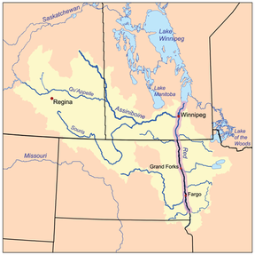
. The flood reached throughout the Red River Valley
, affecting the cities of Fargo
and Winnipeg, while Grand Forks
and East Grand Forks
received the most damage, where floodwaters reached over 3 miles (5 km) inland, inundating virtually everything in the twin communities. Total damages for the Red River region were US$
3.5 billion.
The flood was the result of abundant snowfall and extreme temperatures. Although river levels in Fargo reached record heights, the city was protected by several dikes and received minimal damage. In Grand Forks, however, the river crested at 54 feet (16.5 m), surpassing the 49 feet (14.9 m) estimate of flooding set by the National Weather Service
. Within East Grand Forks, all but eight homes were damaged by floodwaters. Grand Forks mayor Pat Owens
had to order the evacuation of over 50,000 people as a large portion of the city would eventually be flooded. A large fire started in Grand Forks, engulfing eleven buildings and sixty apartment units before being extinguished.
Those affected by the flood received donations from across the nation, along with billions in federal aid. City officials and flood-forecasters were criticized for the difference in estimates and actual flood levels. Fargo, Grand Forks, and East Grand Forks built new dikes to prevent damage from future floods and the Greater Grand Forks area began to rebuild around the river, developing a campground recreation area
, park, and shopping districts where homes once stood.
 The Red River forms the border between North Dakota
and Minnesota
. A few sets of "sister cities" sit directly on this border, including Grand Forks, North Dakota
and its counterpart East Grand Forks, Minnesota
, Fargo, North Dakota
/Moorhead, Minnesota
(Fargo-Moorhead
), and Wahpeton, North Dakota
/Breckenridge, Minnesota
. The Red River in Manitoba and the U.S. states of Minnesota and North Dakota has flooded repeatedly through the centuries, endangering lives and property. The river is highly prone to flooding because of its northward flow. As spring approaches, the snow is melted from south to north alongside the riverflow. There is also the possibility that the surplus water can hit unmelted ice on the river and back up. The flatness of the terrain and small slope of the river is a significant factor.
The first known recorded accounts of floods along the Red River appeared in the 1770s. Severe floods occurred throughout the 1800s and 1900s, with one of the most recent major floods occurring in 1979. Homes not damaged in that flood were incorrectly assumed to be safe from a future flood.
, declaring that there was "...a high spring snowmelt flood potential for the tributaries to the Red River, and a severe spring snowmelt potential for the Red River from Wahpeton, North Dakota to the Canadian border." On February 27, a flood planning meeting in Fargo
revealed that Fargo, Wahpeton
, and Grand Forks would see the Red River rise to 38, 17.9, and 49 feet (14.9 m), respectively. The Corps of Engineers recommended on March 24 that Grand Forks' engineers build dikes to a height of 52 feet (15.8 m), which would provide three feet of leeway for the 49 feet (14.9 m) estimate. Additionally, the Federal Emergency Management Agency
(FEMA) publicly encouraged Grand Forks residents to purchase flood insurance, but only a thousand of the 52,000 residents did so. Later, researchers at the University of North Dakota
determined that although more than 90% of residents knew about the option of purchasing flood insurance, only a small percentage purchased it since they believed the National Weather Service
had projected that the river would not crest high enough to warrant a flood.
On March 31, the North Dakota National Guard
used helicopters to dump sand on ice covering the Red River in an attempt to use the sun's thermal energy to thaw the ice and prevent ice jams. The "dusting" was the most extensive attempt in North Dakota's history. Starting on April 3 and continuing everyday up to the flood, sandbag
ging and dike-building began. Residents, local university students, and Grand Forks Air Force base personnel placed about 3.5 million sandbags at various points around the river.
On April 16, at a public meeting, Grand Forks mayor Pat Owens
recommended that residents voluntarily evacuate the city. The next day, about 500 airmen and women from Grand Forks Air Force Base were assigned to assisting with monitoring the dikes around the river.
 There was some sense of imminent threat in Grand Forks, but the cities could not prepare for such an enormous flood. The National Weather Service
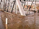
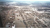
(NWS) had a long-standing forecast for the river to crest at 49 feet (14.9 m), which was the river's highest level during the 1979 flood. The cities had been able to get their dikes to this level, but the river continued to rise past it, to the astonishment of the NWS (which did not upgrade its forecast until April 16, the day the river actually reached 49 feet). The dikes in the low-lying Lincoln Drive neighborhood of Grand Forks were the first to break, doing so early on April 18. Other dikes over the Grand Forks and East Grand Forks area would fail that day and the next, flooding thousands of homes.
 Water would end up reaching areas over two miles (3 km) away from the Red River, necessitating the evacuation of all of East Grand Forks and 75% of Grand Forks. School was canceled in both cities for the remainder of the term, as were classes at the University of North Dakota
. The river crested at 54.35 feet (16.6 m) on April 21 and the river level would not fall below 49 feet (14.9 m) until April 26. The flood reached higher levels than the prior most severe flood in 1826. Because water drained so slowly out of the most low-lying areas, some homeowners could not visit their damaged property until May. By May 30, the Red River had receded below flood stages everywhere in North Dakota.
during the Civil War
. She later reflected on the decision saying, "...if I evacuate this city and nothing happens they're gonna impeach me. But if I don't, we're going to lose lives." Because all transportation was cut off between the two cities (and for many miles, the two states), East Grand Forks residents were evacuated to nearby Crookston
, namely to the University of Minnesota Crookston
, while residents of Grand Forks, who were given mandatory evacuation orders on April 18, went to Grand Forks Air Force Base
(residents stayed in airplane hangars containing more than 3,000 cots).
With the assistance of the National Guard and Air Force personnel, several hundred patients were evacuated from local hospitals with no injuries or loss of life during the evacuation process. Many residents also evacuated to motels and homes in neighboring communities. Some residents of Grand Forks criticized the National Weather Service for its incorrect prediction of the river level, as it had prevented them from securing their possessions from their homes. One resident said: "If they'd said earlier the river would hit 52 feet (15.8 m), I would have moved my stuff out of my house. At 49, it was safe."
 The flood made national news. The most familiar footage is possibly of the fire that started on April 19 in downtown Grand Forks
, surrounded by floodwaters, where eleven buildings and sixty apartments were destroyed. The Grand Forks Herald
building was totally destroyed in the fire, along with 120 years of archives. Firefighters were not able to begin extinguishing the fire immediately as they had to evacuate nearly forty people in one of the nearby apartment complexes who had defied the evacuation order. Additionally, their tankers were unable to reach the buildings due to the height of the floodwater and the water pressure from the hoses and fire hydrants was too weak to extinguish the flames. The National Guard placed the fire trucks on several tractor-trailers to prevent them from flooding, which allowed the firefighters to assist in extinguishing the fire. The firefighters received assistance several hours after the fire started by a fire-bombing plane that dropped retardant
and helicopters who made sixty drops totaling 120,000 gallons of water. Three of the firefighters were treated for hypothermia after treading through the cold temperatures of the flood water. The fire was later determined to have been caused by an electrical problem that had resulted from the large amounts of floodwater.
 The national attention of both flood and fire reached Joan Kroc, the McDonald's heiress, who anonymously (her anonymity was later revealed to the public by the Grand Forks Herald) donated $15,000,000 to be divided into $2,000 portions for each damaged household (though the amount some homeowners received was less due to the huge number of devastated homes; in all 7,500 households received funds). Additionally, another single anonymous donor gave $5 million which was distributed in $1,000 allotments. In November 1997, North Dakota Governor Ed Schafer reported that victims had been assisted by 50,000 relief agency volunteers who had served more than 2 million meals. Additionally, the communities received clothing and supplies that were donated from every U.S. state. During a concert in Fargo
, the rock group KISS
donated the money from sales of a special t-shirt to the Fargo and Grand Forks areas to assist in flood relief.
All told, there was $3.5 billion USD in damages to Grand Forks and East Grand Forks, making it the eighth most expensive natural disaster in the U.S. since 1903. Across North Dakota and Minnesota, there were 4500000 acres (18,210.9 km²) of land covered in water. Thousands of people were relocated after the disaster. In May 1997, the Red Cross conducted a damage assessment of 8,000 North Dakota homes. The report indicated that 519 homes, 53 mobile homes, and 73 apartments had been destroyed by flood waters while 701 homes, 69 mobile homes, and 175 apartments sustained major damage. Inspectors reported that 5,959 homes, 166 mobile homes, and 497 apartments received minor damage. Over 5,200 businesses had been destroyed, damaged, or somehow affected by the winter and spring blizzards and the flood. In Grand Forks alone, 75% of the homes, 315 businesses, and 16 of 22 local schools had been flooded. East Grand Forks had over 500 condemned homes, with only eight homes not damaged by the flood. Grand Forks, losing only 3% of its population from 1997 to 2000, did not fare as badly as its sister city, which lost nearly 17% of its residents. Not a single person was killed in the flood itself.
Bill Clinton
flew over Grand Forks surveying the flooded cities. He then visited the thousands of refugees at the nearby Grand Forks Air Force Base
and commented on the community's spirit, stating "Water cannot wash that away. Fire cannot burn that away. And blizzards cannot freeze that away." President Clinton also declared that the Federal Emergency Management Agency
would compensate 100 percent of the cost of emergency work, instead of the normal 75 percent. He also requested that Congress approve $488 million for various counties within North Dakota, Minnesota, and South Dakota for short and long-term reconstruction efforts.
In June, Canadian Prime Minister
Jean Chrétien
and President Clinton appointed the International Red River Basin Task Force containing members of both countries. The task force's purpose was to find ways to improve flood forecasting.
North Dakota and Minnesota leaders initially asked the federal government for $100 million in disaster relief, but increased their projections to $500 million for Grand Forks and East Grand Forks. Pat Owens went to Washington D.C. to persuade Congress to provide the funds contained in a $5.5 billion relief bill. Although the bill was initially vetoed by President Clinton since he disagreed with additional unrelated legislation being added to the bill, he signed it on June 11. East Grand Forks Mayor Lynn Stauss, reflected on the government assistance to the city, saying: "This community could not have survived without the help of the state and federal government."
Grand Forks received $171 million from the federal program, Community Development Block Grants, which was used for 198 projects within the city. One city worker estimated that 10-15% of the funds went to developing downtown Grand Forks, while the remainder of the grants were distributed to the other projects throughout the city.
 After the flood reached unexpected levels, Senator Kent Conrad
wrote in a letter on April 30 that he was "very concerned about the capability of the National Weather Service to accurately and in a timely manner predict river levels on the Red River in North Dakota." Earl Pomeroy told the Grand Forks Herald that "the inability to get realistic flood numbers certainly hindered the communities' ability to prepare." Although the Grand Forks Corps of Engineers was also criticized for their efforts, they revealed that for the last ten years before the flood, the engineers had tried to convince citizens to
approve the construction of a more extensive flood protection system. Additionally, the head of the river-forecasting for the weather service of North Dakota and Minnesota attributed the rise of the Red River moving faster and higher than previously expected due to the sandbag levees that residents built to protect their homes, as it narrowed the channel of the river.
The 5-foot (1.5 m) discrepancy between the actual crest and that which the NWS had predicted led to widespread anger among locals, especially since the citizens of both cities reached and even slightly surpassed the NWS's level of protection through weeks of hard work. Lynn Staus, the mayor of East Grand Forks initially complained on the NWS's predictions, "They missed it, and they not only missed it, they blew it big." He later commented again, saying "I am not trying to blame the weather bureau. [But] we live day by day by those predictions, and many of our people did not go out and buy flood insurance." Anger over the predictions was most famously expressed by a local resident's devastated home having the words "49 feet my ass" smeared on the exterior.
, mold
, and mildew
, residents were told by city officials to paint the word "Flood" or make some other mark to prevent looting
. Over 60,000 tons of flood debris was hauled to local landfills.
Grand Forks' daily newspaper, the Grand Forks Herald
, continued to publish papers throughout the flood despite having its printing facilities destroyed. Newspapers were printed in St. Paul, Minnesota and flown on a charter plane to Grand Forks for deliveries. For their efforts, the staff of the Herald was awarded the Pulitzer Prize for Public Service
.
 Several local schools were destroyed, prompting the construction of replacements. Because construction was not finished on most of these schools until the end of 1998, hundreds of students spent a year and a half of school in temporary locations ranging from churches to FEMA
-constructed temporary metal buildings, known by locals as "tin bins." Numerous city buildings were also damaged, especially in East Grand Forks, where the flood-ravaged downtown area had been home to the city hall and the public library. Both have since been replaced by new buildings, though not before spending a few years housed in a former elementary school and an ice rink's warming house, respectively.
Both Grand Forks and East Grand Forks had to decide whether to develop the land along the river. The president of the East Grand Forks planning-and-zoning commission commented on the idea of development, "The river had been our friend for all these years. It had been like an old dog, sleeping comfortably at our feet, and then one day it jumped up and bit us. We had to decide: Do we put it to sleep or try to make amends?" What were once entire neighborhoods are now covered by grass and trees, part of an extensive area of parkland called the Greater Grand Forks Greenway. In East Grand Forks, this transformation is especially visible. One former neighborhood is now a large campground, the center of what is now known as the Red River State Recreation Area
. The cities of today are significantly different from their pre-flood state, but many residents are pleased with this, seeing it as fulfillment of President Bill Clinton's promise that the cities would "rebuild stronger and better than ever." Population estimates by the Census Bureau and by the city of Grand Forks itself now show a growing community.
The area continues to experience flooding as another major flood occurred April 2006. However, the Red River did not go near the level of the 1997 flood and only caused minor damage, primarily in rural areas, including water over roads and bridges. The lack of damage done to Grand Forks and East Grand Forks in particular can largely be attributed to the aforementioned improved dikes and Greenway zone.
New dikes have been constructed in Fargo, Grand Forks, and East Grand Forks. Fargo initially had three different plans to choose for developing a dike, and construction of the dike was funded with $10.5 million it received from FEMA and $5.5 million from state funds. For Greater Grand Forks, the system of levees and new "invisible floodwalls" was completed in 2007, having cost several hundred million USD. The areas bordering both sides of the rivers has been converted into a giant park called the Greater Grand Forks Greenway.
Since the flood, Grand Forks' recovery has been used as a model by other communities which have suffered from natural disasters. After Hurricane Katrina
hit several U.S. states in 2005, Grand Forks adopted the city of Biloxi, Mississippi
. Current Grand Forks mayor Michael Brown
stated that it was important "to utilize the experience from those people who went through those disasters, like our fire chief, police chief and public works directors. So we went to Biloxi and said, 'This is what we have learned.'" Grand Forks leaders met with Biloxi city officials, and sent a list of contacts and a 24-page booklet that detailed how to coordinate volunteer agencies and how to interact with FEMA. One Biloxi city official stated that Grand Forks had "just helped us to understand what we were looking at, and gave us some direction to go in, which was really needed, with the rebuilding and the recovering."
By 2007, the population of Grand Forks had resumed the same levels as before the flood. East Grand Forks mayor Lynn Stauss stated "We like to call ourselves the poster child of flood recovery because we think we showed how different governments working together could make it happen."
Flood
A flood is an overflow of an expanse of water that submerges land. The EU Floods directive defines a flood as a temporary covering by water of land not normally covered by water...
that occurred in April 1997, along the Red River of the North
Red River of the North
The Red River is a North American river. Originating at the confluence of the Bois de Sioux and Otter Tail rivers in the United States, it flows northward through the Red River Valley and forms the border between the U.S. states of Minnesota and North Dakota before continuing into Manitoba, Canada...
in North Dakota
North Dakota
North Dakota is a state located in the Midwestern region of the United States of America, along the Canadian border. The state is bordered by Canada to the north, Minnesota to the east, South Dakota to the south and Montana to the west. North Dakota is the 19th-largest state by area in the U.S....
and Minnesota
Minnesota
Minnesota is a U.S. state located in the Midwestern United States. The twelfth largest state of the U.S., it is the twenty-first most populous, with 5.3 million residents. Minnesota was carved out of the eastern half of the Minnesota Territory and admitted to the Union as the thirty-second state...
. The flood reached throughout the Red River Valley
Red River Valley
The Red River Valley is a region in central North America that is drained by the Red River of the North. It is significant in the geography of North Dakota, Minnesota, and Manitoba for its relatively fertile lands and the population centers of Fargo, Moorhead, Grand Forks, and Winnipeg...
, affecting the cities of Fargo
Fargo, North Dakota
Fargo is the largest city in the U.S. state of North Dakota and the county seat of Cass County. In 2010, its population was 105,549, and it had an estimated metropolitan population of 208,777...
and Winnipeg, while Grand Forks
Grand Forks, North Dakota
Grand Forks is the third-largest city in the U.S. state of North Dakota and the county seat of Grand Forks County. According to the 2010 census, the city's population was 52,838, while that of the city and surrounding metropolitan area was 98,461...
and East Grand Forks
East Grand Forks, Minnesota
-K-12:The East Grand Forks School District enrolls over 1,000 students and operates two elementary schools , Central Middle School, and East Grand Forks Senior High School. There are also two private Christian schools. Sacred Heart School is a Roman Catholic elementary, middle, and high school...
received the most damage, where floodwaters reached over 3 miles (5 km) inland, inundating virtually everything in the twin communities. Total damages for the Red River region were US$
United States dollar
The United States dollar , also referred to as the American dollar, is the official currency of the United States of America. It is divided into 100 smaller units called cents or pennies....
3.5 billion.
The flood was the result of abundant snowfall and extreme temperatures. Although river levels in Fargo reached record heights, the city was protected by several dikes and received minimal damage. In Grand Forks, however, the river crested at 54 feet (16.5 m), surpassing the 49 feet (14.9 m) estimate of flooding set by the National Weather Service
National Weather Service
The National Weather Service , once known as the Weather Bureau, is one of the six scientific agencies that make up the National Oceanic and Atmospheric Administration of the United States government...
. Within East Grand Forks, all but eight homes were damaged by floodwaters. Grand Forks mayor Pat Owens
Pat Owens
Patrica A. Owens was the mayor of Grand Forks, North Dakota during the flood that devastated the city in April 1997...
had to order the evacuation of over 50,000 people as a large portion of the city would eventually be flooded. A large fire started in Grand Forks, engulfing eleven buildings and sixty apartment units before being extinguished.
Those affected by the flood received donations from across the nation, along with billions in federal aid. City officials and flood-forecasters were criticized for the difference in estimates and actual flood levels. Fargo, Grand Forks, and East Grand Forks built new dikes to prevent damage from future floods and the Greater Grand Forks area began to rebuild around the river, developing a campground recreation area
Red River State Recreation Area
Red River State Recreation Area is part of the Greater Grand Forks Greenway and is located in the city of East Grand Forks, Minnesota on the banks of the Red River of the North and the Red Lake River. The State Recreation Area is owned and managed by the Minnesota Department of Natural...
, park, and shopping districts where homes once stood.
Red River and prior floods
North Dakota
North Dakota is a state located in the Midwestern region of the United States of America, along the Canadian border. The state is bordered by Canada to the north, Minnesota to the east, South Dakota to the south and Montana to the west. North Dakota is the 19th-largest state by area in the U.S....
and Minnesota
Minnesota
Minnesota is a U.S. state located in the Midwestern United States. The twelfth largest state of the U.S., it is the twenty-first most populous, with 5.3 million residents. Minnesota was carved out of the eastern half of the Minnesota Territory and admitted to the Union as the thirty-second state...
. A few sets of "sister cities" sit directly on this border, including Grand Forks, North Dakota
Grand Forks, North Dakota
Grand Forks is the third-largest city in the U.S. state of North Dakota and the county seat of Grand Forks County. According to the 2010 census, the city's population was 52,838, while that of the city and surrounding metropolitan area was 98,461...
and its counterpart East Grand Forks, Minnesota
East Grand Forks, Minnesota
-K-12:The East Grand Forks School District enrolls over 1,000 students and operates two elementary schools , Central Middle School, and East Grand Forks Senior High School. There are also two private Christian schools. Sacred Heart School is a Roman Catholic elementary, middle, and high school...
, Fargo, North Dakota
Fargo, North Dakota
Fargo is the largest city in the U.S. state of North Dakota and the county seat of Cass County. In 2010, its population was 105,549, and it had an estimated metropolitan population of 208,777...
/Moorhead, Minnesota
Moorhead, Minnesota
Moorhead is a city in Clay County, Minnesota, United States, and the largest city in northwest Minnesota. The population was 38,065 at the 2010 Census. It is the county seat of Clay County....
(Fargo-Moorhead
Fargo-Moorhead
Fargo-Moorhead is a common name given to the metropolitan area comprising Fargo, North Dakota, Moorhead, Minnesota, and the surrounding communities. These two cities lie on the North Dakota-Minnesota border, on opposite banks of the Red River of the North...
), and Wahpeton, North Dakota
Wahpeton, North Dakota
The first European explorer in the area was Jonathan Carver in 1767. He explored and mapped the Northwest at the request of Major Robert Rogers, commander of Fort Michilimackinac, the British fort at Mackinaw City, Michigan, which protected the passage between Lake Michigan and Lake Huron...
/Breckenridge, Minnesota
Breckenridge, Minnesota
As of the census of 2000, there were 3,559 people, 1,438 households, and 911 families residing in the city. The population density was 1,516.4 people per square mile . There were 1,582 housing units at an average density of 674.0 per square mile...
. The Red River in Manitoba and the U.S. states of Minnesota and North Dakota has flooded repeatedly through the centuries, endangering lives and property. The river is highly prone to flooding because of its northward flow. As spring approaches, the snow is melted from south to north alongside the riverflow. There is also the possibility that the surplus water can hit unmelted ice on the river and back up. The flatness of the terrain and small slope of the river is a significant factor.
The first known recorded accounts of floods along the Red River appeared in the 1770s. Severe floods occurred throughout the 1800s and 1900s, with one of the most recent major floods occurring in 1979. Homes not damaged in that flood were incorrectly assumed to be safe from a future flood.
Origins
There were five main factors that contributed to the flood's severity:- Rainstorms in autumn of 1996 had saturated the ground so that it could not absorb much water.
- There was abundant snowfall during the 1996-1997 winter. A total of 98.6 inches (250 cm) of seasonal snow accumulations in FargoFargo, North DakotaFargo is the largest city in the U.S. state of North Dakota and the county seat of Cass County. In 2010, its population was 105,549, and it had an estimated metropolitan population of 208,777...
and 117 inches (297 cm) downstream in Grand Forks along with other record snowfall events covered the Red River of the NorthRed River of the NorthThe Red River is a North American river. Originating at the confluence of the Bois de Sioux and Otter Tail rivers in the United States, it flows northward through the Red River Valley and forms the border between the U.S. states of Minnesota and North Dakota before continuing into Manitoba, Canada...
's watershedDrainage basinA drainage basin is an extent or an area of land where surface water from rain and melting snow or ice converges to a single point, usually the exit of the basin, where the waters join another waterbody, such as a river, lake, reservoir, estuary, wetland, sea, or ocean...
. - Abnormally cold temperatures plagued the Upper Midwest during this particular winter. Between November 7, 1996 and March 18, 1997 (a span of 131 days) the air temperature only reached 40 degrees 3 times in Grand Forks. Because there were only a few days above freezing, there was very little gradual melting of the snow that fell throughout the winter. Starting on March 19, 1997 the temperature then rose above freezing for 27 consecutive days, and only eight days after that would the temperature remain below freezing. However, due to the sudden warmth in April, it melted the deep snowpack too quickly for the river to handle.
- A freak blizzardBlizzardA blizzard is a severe snowstorm characterized by strong winds. By definition, the difference between blizzard and a snowstorm is the strength of the wind. To be a blizzard, a snow storm must have winds in excess of with blowing or drifting snow which reduces visibility to 400 meters or ¼ mile or...
(unofficially named "Hannah" by the Grand Forks Herald) had dumped a large amount of freezing rainFreezing rainFreezing rain is the name given to rain that falls when surface temperatures are below freezing. The raindrops become supercooled while passing through a sub-freezing layer of air, many hundred feet , just above the surface, and then freeze upon impact with any object they encounter. The resulting...
and snow on the Red River Valley on the weekend of April 5, 1997. - Tributary peak flows tended to coincide with those on the Red River itself.
Preparations
The first flood outlook was issued on February 13, 1997 by the National Weather ServiceNational Weather Service
The National Weather Service , once known as the Weather Bureau, is one of the six scientific agencies that make up the National Oceanic and Atmospheric Administration of the United States government...
, declaring that there was "...a high spring snowmelt flood potential for the tributaries to the Red River, and a severe spring snowmelt potential for the Red River from Wahpeton, North Dakota to the Canadian border." On February 27, a flood planning meeting in Fargo
Fargo, North Dakota
Fargo is the largest city in the U.S. state of North Dakota and the county seat of Cass County. In 2010, its population was 105,549, and it had an estimated metropolitan population of 208,777...
revealed that Fargo, Wahpeton
Wahpeton, North Dakota
The first European explorer in the area was Jonathan Carver in 1767. He explored and mapped the Northwest at the request of Major Robert Rogers, commander of Fort Michilimackinac, the British fort at Mackinaw City, Michigan, which protected the passage between Lake Michigan and Lake Huron...
, and Grand Forks would see the Red River rise to 38, 17.9, and 49 feet (14.9 m), respectively. The Corps of Engineers recommended on March 24 that Grand Forks' engineers build dikes to a height of 52 feet (15.8 m), which would provide three feet of leeway for the 49 feet (14.9 m) estimate. Additionally, the Federal Emergency Management Agency
Federal Emergency Management Agency
The Federal Emergency Management Agency is an agency of the United States Department of Homeland Security, initially created by Presidential Reorganization Plan No. 1 of 1978 and implemented by two Executive Orders...
(FEMA) publicly encouraged Grand Forks residents to purchase flood insurance, but only a thousand of the 52,000 residents did so. Later, researchers at the University of North Dakota
University of North Dakota
The University of North Dakota is a public university in Grand Forks, North Dakota, USA. Established by the Dakota Territorial Assembly in 1883, six years before the establishment of the state of North Dakota, UND is the oldest and largest university in the state and enrolls over 14,000 students. ...
determined that although more than 90% of residents knew about the option of purchasing flood insurance, only a small percentage purchased it since they believed the National Weather Service
National Weather Service
The National Weather Service , once known as the Weather Bureau, is one of the six scientific agencies that make up the National Oceanic and Atmospheric Administration of the United States government...
had projected that the river would not crest high enough to warrant a flood.
On March 31, the North Dakota National Guard
North Dakota National Guard
The North Dakota National Guard consists of the:*North Dakota Army National Guard*North Dakota Air National GuardIt is part of the North Dakota Department of Emergency Services.-External links:* compiled by the United States Army Center of Military History...
used helicopters to dump sand on ice covering the Red River in an attempt to use the sun's thermal energy to thaw the ice and prevent ice jams. The "dusting" was the most extensive attempt in North Dakota's history. Starting on April 3 and continuing everyday up to the flood, sandbag
Sandbag
A sandbag is a sack made of hessian/burlap, polypropylene or other materials that is filled with sand or soil and used for such purposes as flood control, military fortification, shielding glass windows in war zones and ballast....
ging and dike-building began. Residents, local university students, and Grand Forks Air Force base personnel placed about 3.5 million sandbags at various points around the river.
On April 16, at a public meeting, Grand Forks mayor Pat Owens
Pat Owens
Patrica A. Owens was the mayor of Grand Forks, North Dakota during the flood that devastated the city in April 1997...
recommended that residents voluntarily evacuate the city. The next day, about 500 airmen and women from Grand Forks Air Force Base were assigned to assisting with monitoring the dikes around the river.
The flood in Fargo
The Red River crested in Fargo at 39.5 feet (12 m) on April 17, but dike-building efforts were able to prevent the water from flooding into a majority of the city. An emergency dike was built and volunteers had to add sandbags to increase the height of a dike that had settled. The Fargo mayor at the time, Bruce Furness, later stated: "We came very, very close to losing parts of Fargo...it took a lot of effort by a lot of people—a great many of them high school and college students—to save the city. I was very proud of them. I think it was one of Fargo's finest moments."The flood in Greater Grand Forks
National Weather Service
The National Weather Service , once known as the Weather Bureau, is one of the six scientific agencies that make up the National Oceanic and Atmospheric Administration of the United States government...
(NWS) had a long-standing forecast for the river to crest at 49 feet (14.9 m), which was the river's highest level during the 1979 flood. The cities had been able to get their dikes to this level, but the river continued to rise past it, to the astonishment of the NWS (which did not upgrade its forecast until April 16, the day the river actually reached 49 feet). The dikes in the low-lying Lincoln Drive neighborhood of Grand Forks were the first to break, doing so early on April 18. Other dikes over the Grand Forks and East Grand Forks area would fail that day and the next, flooding thousands of homes.
University of North Dakota
The University of North Dakota is a public university in Grand Forks, North Dakota, USA. Established by the Dakota Territorial Assembly in 1883, six years before the establishment of the state of North Dakota, UND is the oldest and largest university in the state and enrolls over 14,000 students. ...
. The river crested at 54.35 feet (16.6 m) on April 21 and the river level would not fall below 49 feet (14.9 m) until April 26. The flood reached higher levels than the prior most severe flood in 1826. Because water drained so slowly out of the most low-lying areas, some homeowners could not visit their damaged property until May. By May 30, the Red River had receded below flood stages everywhere in North Dakota.
Evacuations
When the dikes in Grand Forks could not keep out the flooding river, Pat Owens ordered the evacuation of over 50,000 people on April 18, which up to that time, had been the largest civilian evacuation in the United States since the evacuation of residents in Atlanta, GeorgiaAtlanta, Georgia
Atlanta is the capital and most populous city in the U.S. state of Georgia. According to the 2010 census, Atlanta's population is 420,003. Atlanta is the cultural and economic center of the Atlanta metropolitan area, which is home to 5,268,860 people and is the ninth largest metropolitan area in...
during the Civil War
American Civil War
The American Civil War was a civil war fought in the United States of America. In response to the election of Abraham Lincoln as President of the United States, 11 southern slave states declared their secession from the United States and formed the Confederate States of America ; the other 25...
. She later reflected on the decision saying, "...if I evacuate this city and nothing happens they're gonna impeach me. But if I don't, we're going to lose lives." Because all transportation was cut off between the two cities (and for many miles, the two states), East Grand Forks residents were evacuated to nearby Crookston
Crookston, Minnesota
As of the census of 2000, there were 8,192 people, 3,078 households, and 1,819 families residing in the city. The population density was 1,658.8 people per square mile . There were 3,382 housing units at an average density of 684.8 per square mile...
, namely to the University of Minnesota Crookston
University of Minnesota Crookston
The University of Minnesota, Crookston is a four-year university located in Crookston, Minnesota. With 1,600 undergraduate students , it is one of five campuses in the University of Minnesota system. Currently, students from 29 countries and 40 states are enrolled .Located on the northern edge of...
, while residents of Grand Forks, who were given mandatory evacuation orders on April 18, went to Grand Forks Air Force Base
Grand Forks Air Force Base
Grand Forks Air Force Base is a United States Air Force base located north of Emerado, North Dakota and approximately west of Grand Forks, North Dakota...
(residents stayed in airplane hangars containing more than 3,000 cots).
With the assistance of the National Guard and Air Force personnel, several hundred patients were evacuated from local hospitals with no injuries or loss of life during the evacuation process. Many residents also evacuated to motels and homes in neighboring communities. Some residents of Grand Forks criticized the National Weather Service for its incorrect prediction of the river level, as it had prevented them from securing their possessions from their homes. One resident said: "If they'd said earlier the river would hit 52 feet (15.8 m), I would have moved my stuff out of my house. At 49, it was safe."
Downtown Grand Forks fire
Downtown Grand Forks
Downtown Grand Forks is the original commercial center of Grand Forks, North Dakota. Located on the western bank of the Red River of the North, the downtown neighborhood is situated near the fork of the Red River and the Red Lake River. While downtown is no longer the dominant commercial area of...
, surrounded by floodwaters, where eleven buildings and sixty apartments were destroyed. The Grand Forks Herald
Grand Forks Herald
The Grand Forks Herald is a daily broadsheet newspaper, begun in 1879, published in Grand Forks, North Dakota. It is the primary daily paper for northeast North Dakota and northwest Minnesota. Its average daily circulation is 34,763 on Sundays and 31,524 on weekdays...
building was totally destroyed in the fire, along with 120 years of archives. Firefighters were not able to begin extinguishing the fire immediately as they had to evacuate nearly forty people in one of the nearby apartment complexes who had defied the evacuation order. Additionally, their tankers were unable to reach the buildings due to the height of the floodwater and the water pressure from the hoses and fire hydrants was too weak to extinguish the flames. The National Guard placed the fire trucks on several tractor-trailers to prevent them from flooding, which allowed the firefighters to assist in extinguishing the fire. The firefighters received assistance several hours after the fire started by a fire-bombing plane that dropped retardant
Fire retardant
A fire retardant is a substance other than water that reduces flammability of fuels or delays their combustion. This typically refers to chemical retardants but may also include substances that work by physical action, such as cooling the fuels; examples of these include fire-fighting foams and...
and helicopters who made sixty drops totaling 120,000 gallons of water. Three of the firefighters were treated for hypothermia after treading through the cold temperatures of the flood water. The fire was later determined to have been caused by an electrical problem that had resulted from the large amounts of floodwater.
Donations and damages
Fargo, North Dakota
Fargo is the largest city in the U.S. state of North Dakota and the county seat of Cass County. In 2010, its population was 105,549, and it had an estimated metropolitan population of 208,777...
, the rock group KISS
KISS (band)
Kiss is an American rock band formed in New York City in January 1973. Well-known for its members' face paint and flamboyant stage outfits, the group rose to prominence in the mid to late 1970s on the basis of their elaborate live performances, which featured fire breathing, blood spitting,...
donated the money from sales of a special t-shirt to the Fargo and Grand Forks areas to assist in flood relief.
All told, there was $3.5 billion USD in damages to Grand Forks and East Grand Forks, making it the eighth most expensive natural disaster in the U.S. since 1903. Across North Dakota and Minnesota, there were 4500000 acres (18,210.9 km²) of land covered in water. Thousands of people were relocated after the disaster. In May 1997, the Red Cross conducted a damage assessment of 8,000 North Dakota homes. The report indicated that 519 homes, 53 mobile homes, and 73 apartments had been destroyed by flood waters while 701 homes, 69 mobile homes, and 175 apartments sustained major damage. Inspectors reported that 5,959 homes, 166 mobile homes, and 497 apartments received minor damage. Over 5,200 businesses had been destroyed, damaged, or somehow affected by the winter and spring blizzards and the flood. In Grand Forks alone, 75% of the homes, 315 businesses, and 16 of 22 local schools had been flooded. East Grand Forks had over 500 condemned homes, with only eight homes not damaged by the flood. Grand Forks, losing only 3% of its population from 1997 to 2000, did not fare as badly as its sister city, which lost nearly 17% of its residents. Not a single person was killed in the flood itself.
Federal and state response and assistance
On April 22, PresidentPresident of the United States
The President of the United States of America is the head of state and head of government of the United States. The president leads the executive branch of the federal government and is the commander-in-chief of the United States Armed Forces....
Bill Clinton
Bill Clinton
William Jefferson "Bill" Clinton is an American politician who served as the 42nd President of the United States from 1993 to 2001. Inaugurated at age 46, he was the third-youngest president. He took office at the end of the Cold War, and was the first president of the baby boomer generation...
flew over Grand Forks surveying the flooded cities. He then visited the thousands of refugees at the nearby Grand Forks Air Force Base
Grand Forks Air Force Base
Grand Forks Air Force Base is a United States Air Force base located north of Emerado, North Dakota and approximately west of Grand Forks, North Dakota...
and commented on the community's spirit, stating "Water cannot wash that away. Fire cannot burn that away. And blizzards cannot freeze that away." President Clinton also declared that the Federal Emergency Management Agency
Federal Emergency Management Agency
The Federal Emergency Management Agency is an agency of the United States Department of Homeland Security, initially created by Presidential Reorganization Plan No. 1 of 1978 and implemented by two Executive Orders...
would compensate 100 percent of the cost of emergency work, instead of the normal 75 percent. He also requested that Congress approve $488 million for various counties within North Dakota, Minnesota, and South Dakota for short and long-term reconstruction efforts.
In June, Canadian Prime Minister
Prime Minister of Canada
The Prime Minister of Canada is the primary minister of the Crown, chairman of the Cabinet, and thus head of government for Canada, charged with advising the Canadian monarch or viceroy on the exercise of the executive powers vested in them by the constitution...
Jean Chrétien
Jean Chrétien
Joseph Jacques Jean Chrétien , known commonly as Jean Chrétien is a former Canadian politician who was the 20th Prime Minister of Canada. He served in the position for over ten years, from November 4, 1993 to December 12, 2003....
and President Clinton appointed the International Red River Basin Task Force containing members of both countries. The task force's purpose was to find ways to improve flood forecasting.
North Dakota and Minnesota leaders initially asked the federal government for $100 million in disaster relief, but increased their projections to $500 million for Grand Forks and East Grand Forks. Pat Owens went to Washington D.C. to persuade Congress to provide the funds contained in a $5.5 billion relief bill. Although the bill was initially vetoed by President Clinton since he disagreed with additional unrelated legislation being added to the bill, he signed it on June 11. East Grand Forks Mayor Lynn Stauss, reflected on the government assistance to the city, saying: "This community could not have survived without the help of the state and federal government."
Grand Forks received $171 million from the federal program, Community Development Block Grants, which was used for 198 projects within the city. One city worker estimated that 10-15% of the funds went to developing downtown Grand Forks, while the remainder of the grants were distributed to the other projects throughout the city.
Criticism and blame
Kent Conrad
Kent Conrad is the senior United States Senator from North Dakota. He is a member of the North Dakota Democratic-NPL Party, the North Dakota affiliate of the Democratic Party...
wrote in a letter on April 30 that he was "very concerned about the capability of the National Weather Service to accurately and in a timely manner predict river levels on the Red River in North Dakota." Earl Pomeroy told the Grand Forks Herald that "the inability to get realistic flood numbers certainly hindered the communities' ability to prepare." Although the Grand Forks Corps of Engineers was also criticized for their efforts, they revealed that for the last ten years before the flood, the engineers had tried to convince citizens to
approve the construction of a more extensive flood protection system. Additionally, the head of the river-forecasting for the weather service of North Dakota and Minnesota attributed the rise of the Red River moving faster and higher than previously expected due to the sandbag levees that residents built to protect their homes, as it narrowed the channel of the river.
The 5-foot (1.5 m) discrepancy between the actual crest and that which the NWS had predicted led to widespread anger among locals, especially since the citizens of both cities reached and even slightly surpassed the NWS's level of protection through weeks of hard work. Lynn Staus, the mayor of East Grand Forks initially complained on the NWS's predictions, "They missed it, and they not only missed it, they blew it big." He later commented again, saying "I am not trying to blame the weather bureau. [But] we live day by day by those predictions, and many of our people did not go out and buy flood insurance." Anger over the predictions was most famously expressed by a local resident's devastated home having the words "49 feet my ass" smeared on the exterior.
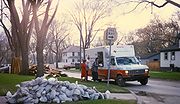
Recovery
Over 20,000 volunteers went to Grand Forks to assist in recovery efforts. The Red Cross dispersed over 25,000 clean-up kits (containing bleach, cleaning materials, goggles, and other equipment) funded by the State Department of Health that owners used to clean their flood-damaged property and possessions. Since many possessions and appliances were contaminated by flood water, sewageSewage
Sewage is water-carried waste, in solution or suspension, that is intended to be removed from a community. Also known as wastewater, it is more than 99% water and is characterized by volume or rate of flow, physical condition, chemical constituents and the bacteriological organisms that it contains...
, mold
Mold
Molds are fungi that grow in the form of multicellular filaments called hyphae. Molds are not considered to be microbes but microscopic fungi that grow as single cells called yeasts...
, and mildew
Mildew
Mildew refers to certain kinds of molds or fungi.In Old English, it meant honeydew , and later came to mean mildew in the modern sense of mold or fungus....
, residents were told by city officials to paint the word "Flood" or make some other mark to prevent looting
Looting
Looting —also referred to as sacking, plundering, despoiling, despoliation, and pillaging—is the indiscriminate taking of goods by force as part of a military or political victory, or during a catastrophe, such as during war, natural disaster, or rioting...
. Over 60,000 tons of flood debris was hauled to local landfills.
Grand Forks' daily newspaper, the Grand Forks Herald
Grand Forks Herald
The Grand Forks Herald is a daily broadsheet newspaper, begun in 1879, published in Grand Forks, North Dakota. It is the primary daily paper for northeast North Dakota and northwest Minnesota. Its average daily circulation is 34,763 on Sundays and 31,524 on weekdays...
, continued to publish papers throughout the flood despite having its printing facilities destroyed. Newspapers were printed in St. Paul, Minnesota and flown on a charter plane to Grand Forks for deliveries. For their efforts, the staff of the Herald was awarded the Pulitzer Prize for Public Service
Pulitzer Prize for Public Service
The Pulitzer Prize for Public Service has been awarded since 1918 for a distinguished example of meritorious public service by a newspaper or news site through the use of its journalistic resources. Those resources, as well as reporting, may include editorials, cartoons, photographs, graphics,...
.
Federal Emergency Management Agency
The Federal Emergency Management Agency is an agency of the United States Department of Homeland Security, initially created by Presidential Reorganization Plan No. 1 of 1978 and implemented by two Executive Orders...
-constructed temporary metal buildings, known by locals as "tin bins." Numerous city buildings were also damaged, especially in East Grand Forks, where the flood-ravaged downtown area had been home to the city hall and the public library. Both have since been replaced by new buildings, though not before spending a few years housed in a former elementary school and an ice rink's warming house, respectively.
Both Grand Forks and East Grand Forks had to decide whether to develop the land along the river. The president of the East Grand Forks planning-and-zoning commission commented on the idea of development, "The river had been our friend for all these years. It had been like an old dog, sleeping comfortably at our feet, and then one day it jumped up and bit us. We had to decide: Do we put it to sleep or try to make amends?" What were once entire neighborhoods are now covered by grass and trees, part of an extensive area of parkland called the Greater Grand Forks Greenway. In East Grand Forks, this transformation is especially visible. One former neighborhood is now a large campground, the center of what is now known as the Red River State Recreation Area
Red River State Recreation Area
Red River State Recreation Area is part of the Greater Grand Forks Greenway and is located in the city of East Grand Forks, Minnesota on the banks of the Red River of the North and the Red Lake River. The State Recreation Area is owned and managed by the Minnesota Department of Natural...
. The cities of today are significantly different from their pre-flood state, but many residents are pleased with this, seeing it as fulfillment of President Bill Clinton's promise that the cities would "rebuild stronger and better than ever." Population estimates by the Census Bureau and by the city of Grand Forks itself now show a growing community.
Future flood prevention
The National Weather Service has since revised their method of forecasting spring floods. Increased technology and funding has allowed for the mapping of the entire Red River bottom, more flood monitoring gauges, and up-to-date satellite images of the river at various flood stages.The area continues to experience flooding as another major flood occurred April 2006. However, the Red River did not go near the level of the 1997 flood and only caused minor damage, primarily in rural areas, including water over roads and bridges. The lack of damage done to Grand Forks and East Grand Forks in particular can largely be attributed to the aforementioned improved dikes and Greenway zone.
New dikes have been constructed in Fargo, Grand Forks, and East Grand Forks. Fargo initially had three different plans to choose for developing a dike, and construction of the dike was funded with $10.5 million it received from FEMA and $5.5 million from state funds. For Greater Grand Forks, the system of levees and new "invisible floodwalls" was completed in 2007, having cost several hundred million USD. The areas bordering both sides of the rivers has been converted into a giant park called the Greater Grand Forks Greenway.
Since the flood, Grand Forks' recovery has been used as a model by other communities which have suffered from natural disasters. After Hurricane Katrina
Hurricane Katrina
Hurricane Katrina of the 2005 Atlantic hurricane season was a powerful Atlantic hurricane. It is the costliest natural disaster, as well as one of the five deadliest hurricanes, in the history of the United States. Among recorded Atlantic hurricanes, it was the sixth strongest overall...
hit several U.S. states in 2005, Grand Forks adopted the city of Biloxi, Mississippi
Biloxi, Mississippi
Biloxi is a city in Harrison County, Mississippi, in the United States. The 2010 census recorded the population as 44,054. Along with Gulfport, Biloxi is a county seat of Harrison County....
. Current Grand Forks mayor Michael Brown
Michael Brown (mayor)
Michael Brown is the mayor of Grand Forks, North Dakota as of 2008. He spent his childhood in Okinawa and came to Grand Forks as an United States Air Force officer. He attended the University of North Dakota School of Medicine. Today, Brown is an obstetrician at Altru Health System in Grand...
stated that it was important "to utilize the experience from those people who went through those disasters, like our fire chief, police chief and public works directors. So we went to Biloxi and said, 'This is what we have learned.'" Grand Forks leaders met with Biloxi city officials, and sent a list of contacts and a 24-page booklet that detailed how to coordinate volunteer agencies and how to interact with FEMA. One Biloxi city official stated that Grand Forks had "just helped us to understand what we were looking at, and gave us some direction to go in, which was really needed, with the rebuilding and the recovering."
By 2007, the population of Grand Forks had resumed the same levels as before the flood. East Grand Forks mayor Lynn Stauss stated "We like to call ourselves the poster child of flood recovery because we think we showed how different governments working together could make it happen."
Cultural references
- Grand Forks native Tom BrosseauTom BrosseauTom Brosseau is an American musical storyteller and guitarist, born and raised in Grand Forks, North Dakota.-Biography:Fat Cat Records artist Tom Brosseau tours and performs in the US, UK, Europe, Japan and Taiwan. In the Los Angeles area his home club is Largo. His song "How to Grow a Woman from...
's 2007 album entitled Grand ForksGrand Forks (album)Grand Forks is a 2007 concept album by Tom Brosseau. It is about the devastating Red River Flood of 1997 which struck Brosseau's hometown of Grand Forks, North Dakota. Co-produced by John Doe...
is a concept albumConcept albumIn music, a concept album is an album that is "unified by a theme, which can be instrumental, compositional, narrative, or lyrical." Commonly, concept albums tend to incorporate preconceived musical or lyrical ideas rather than being improvised or composed in the studio, with all songs contributing...
about the flood of 1997. His 2005 album, What I Mean To Say Is GoodbyeWhat I Mean to Say Is GoodbyeWhat I Mean To Say Is Goodbye is a 2005 album by Tom Brosseau.-Track listing:All songs written by Tom Brosseau except tracks 8 and 10.#"West of Town"#"Jane and Lou"#"Tonight I'm Careful With You"#"Wandering"#"Too Much Wear And Tear To Care"...
, references the flood during its opening track, "West of Town".
- Two months after the flood, alternative rock band Soul AsylumSoul AsylumSoul Asylum is an American alternative rock band that formed in Minneapolis, Minnesota in 1983.The band originally formed in 1981 under the name Loud Fast Rules, with the original line-up consisting of Dan Murphy, Dave Pirner, Karl Mueller and Pat Morley. The latter was replaced by Grant Young in...
played at the joint prom held for Grand Forks high school students. The event took place in a hangar at nearby Grand Forks Air Force BaseGrand Forks Air Force BaseGrand Forks Air Force Base is a United States Air Force base located north of Emerado, North Dakota and approximately west of Grand Forks, North Dakota...
. In 2004, the band released a live album of the concert, entitled After the Flood: Live from the Grand Forks Prom, June 28, 1997After the Flood: Live from the Grand Forks Prom, June 28, 1997After the Flood: Live from the Grand Forks Prom, June 28, 1997 is the first live album released by Soul Asylum. It was recorded on June 28, 1997 about two months after the epic Red River Flood of 1997 hit the city of Grand Forks, North Dakota. Soul Asylum played the concert for the joint prom...
.
- After the flood, the Summer Performing Arts CompanySummer Performing Arts CompanyThe Summer Performing Arts Company is a summerstock educational theatre program in Grand Forks, North Dakota that is part of the Grand Forks Public Schools...
produced Keep The Faith, a musical written by Summer Performing Arts staff and area composers and musicians about the flood and the recovery. In 2007 a 10-year anniversary performance of Keep The Faith was held and prompted James Lee WittJames Lee WittJames Lee Witt was Director of the Federal Emergency Management Agency during the administration of President Bill Clinton....
to suggest SPA bring the musical to the Super BowlSuper BowlThe Super Bowl is the championship game of the National Football League , the highest level of professional American football in the United States, culminating a season that begins in the late summer of the previous calendar year. The Super Bowl uses Roman numerals to identify each game, rather...
in New Orleans.
See also
- 1950 Red River Flood
- 1997 Red River Flood in Canada
- 2009 Red River Flood2009 Red River floodThe 2009 Red River flood along the Red River of the North in North Dakota and Minnesota in the United States and Manitoba in Canada brought record flood levels to the Fargo-Moorhead area. The flood was a result of saturated and frozen ground, Spring snowmelt exacerbated by additional rain and snow...