
Great Storm of 1975
Encyclopedia
The Great Storm of 1975 (also known as the Super Bowl Blizzard, Minnesota's Storm of the Century, or the Tornado Outbreak of January, 1975) was an intense storm system that impacted a large portion of the Central
and Southeast United States from January 9 to January 12, 1975. The storm
produced 45 tornado
es in the Southeast U.S. resulting in 12 fatalities, while later dropping over 2 feet (61 cm) of snow
and killing 58 people in the Midwest. This storm remains one of the worst blizzards to ever strike parts of the Midwest, as well as one of the largest January tornado outbreaks on record in the United States
.
and crashed into the Northwest Pacific coast
with damaging gale-force winds on January 8, 1975. By January 9 it had cleared the Rocky Mountains
and began to redevelop and strengthen. At the same time, Arctic
air was being drawn southward from Canada
into the Great Plains
, and large amounts of warm tropical air
from the Gulf of Mexico
were being pulled northward into much of the eastern U.S
. The storm was a classic Panhandle Hook
which moved from Colorado
into Oklahoma
before turning northward towards the Upper Midwest
. It produced record low barometric pressure readings in the Midwest, with the pressure falling to an estimated 28.38 in (961 mb) just north of the Minnesota
border in Canada.
 An unusual feature of this outbreak
was that daytime heating
, typically a key ingredient in the formation of tornadoes
, had very little impact on their development. Rather, as the storm system pulled out into the central plains
, strong thunderstorms and tornadoes quickly began to form despite the late hours. The first two tornadoes in the outbreak touched down after 10:00 p.m. CST on January 9 in Oklahoma and Louisiana
. From there the progression of the twisters shifted eastward through the overnight and early morning hours, setting the stage for what would turn out to be a record setting day on January 10. Texas
saw five tornadoes between 1:30 a.m.–3:30 a.m., one tornado touched down in Arkansas
at 6:00 a.m., Louisiana saw seven tornadoes between 5:30 a.m.–8:00 a.m. (killing one person), Mississippi
had five tornadoes between 8:15 a.m.–10:00 a.m. (killing nine), and Illinois
and Indiana
each experienced three lunch-hour tornadoes. The tornadic line of storms then shifted into Alabama
(killing one) and Florida
during the afternoon and evening hours.
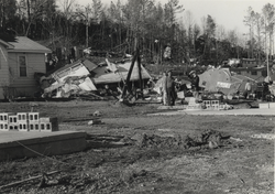
Mississippi and Alabama were the two states hardest hit by this outbreak. Alabama saw the most twisters of any state with 13, but Mississippi saw the largest and deadliest tornado. An F4
tornado that tore through Pike, Lincoln
, Lawrence
, and Simpson Counties
at 8:14 a.m. killed nine people and injured over 200; severely damaging 38 blocks in the town of McComb. The 39 tornadoes that touched down on January 10 marked the most active tornadic day in January in U.S. history at that time. The 52 tornadoes that touched down during January 1975 also set a U.S. record for the most tornadoes during that month. Both of these records were eventually broken in January of 1999
.
After a calm day on January 11, four more tornadoes touched down in Florida and Georgia
on January 12, killing one person in Florida. By the time the outbreak was done it had produced 45 tornadoes, killed 12 people, injured 377 and caused $42 million in damages.
began to move northeastward out of Oklahoma, the cool air behind pulled down behind the system interacted with the moisture
being pulled northward to produce snow over a large part of the Midwest. The snow began falling on Friday, January 10 and continued for the next two days. Snowfall of a foot (30.5 cm) or more was common from Nebraska
to Minnesota, with a high amount of 27 inches (69 cm) in Riverton, Minnesota
. The heaviest snow fell to the west of the low pressure center, which tracked from northeast Iowa
through central Minnesota up to Lake Superior
. Sustained winds of 30 – 50 mph (48 – 80 km/h) with gusts from 70 – 90 mph (113 – 145 km/h) produced snowdrift
s up to 20 feet (6 m) in some locations. Some roads were closed for up to 11 days.
Sioux Falls, South Dakota
saw visibilities
of below 1/4 mi for 24 straight hours, and just east of Sioux Falls a 2,000-foot (610 m) broadcast tower collapsed under the storm's fury. In Willmar, Minnesota
, 168 passengers were trapped in a stranded train for hours, unable to walk to shelter because of dangerously low wind chill
values. In Omaha, Nebraska
a foot (31 cm) of snow fell, Sioux Falls saw 7 inches (18 cm), Duluth, Minnesota
saw 8 inches (20 cm), and International Falls, Minnesota
saw 24 inches (61 cm).
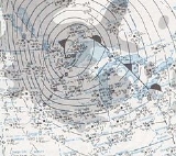
Record low pressures
were recorded in communities in Nebraska, Minnesota, Illinois, and Wisconsin
, with a low of 28.55 in (966.8 mb) in Duluth, Minnesota. In all, approximately 58 people died from effects of the blizzard and over 100,000 farm animals were lost. The combination of snowfall totals, wind velocities, and cold temperature
s made this one of the worst blizzards the Upper Midwest has experienced.
Central United States
The Central United States is sometimes conceived as between the Eastern United States and Western United States as part of a three-region model, roughly coincident with the Midwestern United States plus the western and central portions of the Southern United States; the term is also sometimes used...
and Southeast United States from January 9 to January 12, 1975. The storm
Storm
A storm is any disturbed state of an astronomical body's atmosphere, especially affecting its surface, and strongly implying severe weather...
produced 45 tornado
Tornado
A tornado is a violent, dangerous, rotating column of air that is in contact with both the surface of the earth and a cumulonimbus cloud or, in rare cases, the base of a cumulus cloud. They are often referred to as a twister or a cyclone, although the word cyclone is used in meteorology in a wider...
es in the Southeast U.S. resulting in 12 fatalities, while later dropping over 2 feet (61 cm) of snow
Snow
Snow is a form of precipitation within the Earth's atmosphere in the form of crystalline water ice, consisting of a multitude of snowflakes that fall from clouds. Since snow is composed of small ice particles, it is a granular material. It has an open and therefore soft structure, unless packed by...
and killing 58 people in the Midwest. This storm remains one of the worst blizzards to ever strike parts of the Midwest, as well as one of the largest January tornado outbreaks on record in the United States
United States
The United States of America is a federal constitutional republic comprising fifty states and a federal district...
.
Meteorological synopsis
The storm originated over the Pacific OceanPacific Ocean
The Pacific Ocean is the largest of the Earth's oceanic divisions. It extends from the Arctic in the north to the Southern Ocean in the south, bounded by Asia and Australia in the west, and the Americas in the east.At 165.2 million square kilometres in area, this largest division of the World...
and crashed into the Northwest Pacific coast
Pacific Coast
A country's Pacific coast is the part of its coast bordering the Pacific Ocean.-The Americas:Countries on the western side of the Americas have a Pacific coast as their western border.* Geography of Canada* Geography of Chile* Geography of Colombia...
with damaging gale-force winds on January 8, 1975. By January 9 it had cleared the Rocky Mountains
Rocky Mountains
The Rocky Mountains are a major mountain range in western North America. The Rocky Mountains stretch more than from the northernmost part of British Columbia, in western Canada, to New Mexico, in the southwestern United States...
and began to redevelop and strengthen. At the same time, Arctic
Arctic
The Arctic is a region located at the northern-most part of the Earth. The Arctic consists of the Arctic Ocean and parts of Canada, Russia, Greenland, the United States, Norway, Sweden, Finland, and Iceland. The Arctic region consists of a vast, ice-covered ocean, surrounded by treeless permafrost...
air was being drawn southward from Canada
Canada
Canada is a North American country consisting of ten provinces and three territories. Located in the northern part of the continent, it extends from the Atlantic Ocean in the east to the Pacific Ocean in the west, and northward into the Arctic Ocean...
into the Great Plains
Great Plains
The Great Plains are a broad expanse of flat land, much of it covered in prairie, steppe and grassland, which lies west of the Mississippi River and east of the Rocky Mountains in the United States and Canada. This area covers parts of the U.S...
, and large amounts of warm tropical air
Air mass
In meteorology, an air mass is a volume of air defined by its temperature and water vapor content. Air masses cover many hundreds or thousands of square miles, and adopt the characteristics of the surface below them. They are classified according to latitude and their continental or maritime...
from the Gulf of Mexico
Gulf of Mexico
The Gulf of Mexico is a partially landlocked ocean basin largely surrounded by the North American continent and the island of Cuba. It is bounded on the northeast, north and northwest by the Gulf Coast of the United States, on the southwest and south by Mexico, and on the southeast by Cuba. In...
were being pulled northward into much of the eastern U.S
Eastern United States
The Eastern United States, the American East, or simply the East is traditionally defined as the states east of the Mississippi River. The first two tiers of states west of the Mississippi have traditionally been considered part of the West, but can be included in the East today; usually in...
. The storm was a classic Panhandle Hook
Panhandle hook
A Panhandle hook is a relatively infrequent storm system whose cyclogenesis occurs in the South to southwestern United States from the late fall through winter and into the early spring months...
which moved from Colorado
Colorado
Colorado is a U.S. state that encompasses much of the Rocky Mountains as well as the northeastern portion of the Colorado Plateau and the western edge of the Great Plains...
into Oklahoma
Oklahoma
Oklahoma is a state located in the South Central region of the United States of America. With an estimated 3,751,351 residents as of the 2010 census and a land area of 68,667 square miles , Oklahoma is the 28th most populous and 20th-largest state...
before turning northward towards the Upper Midwest
Upper Midwest
The Upper Midwest is a region in the northern portion of the U.S. Census Bureau's Midwestern United States. It is largely a sub-region of the midwest. Although there are no uniformly agreed-upon boundaries, the region is most commonly used to refer to the states of Minnesota, Wisconsin, and...
. It produced record low barometric pressure readings in the Midwest, with the pressure falling to an estimated 28.38 in (961 mb) just north of the Minnesota
Minnesota
Minnesota is a U.S. state located in the Midwestern United States. The twelfth largest state of the U.S., it is the twenty-first most populous, with 5.3 million residents. Minnesota was carved out of the eastern half of the Minnesota Territory and admitted to the Union as the thirty-second state...
border in Canada.
Tornado summary event
Tornado outbreak
While there is no single agreed upon definition, generally at least 6-10 tornadoes produced by the same synoptic scale weather system is considered a tornado outbreak. The tornadoes usually occur within the same day, or continue into the early morning hours of the succeeding day, and within the...
was that daytime heating
Convective available potential energy
In meteorology, convective available potential energy , sometimes, simply, available potential energy , is the amount of energy a parcel of air would have if lifted a certain distance vertically through the atmosphere...
, typically a key ingredient in the formation of tornadoes
Tornadogenesis
Tornadogenesis is the process by which a tornado forms. There are many types of tornadoes, and each type of tornado can have several different methods of formation. Scientific study is ongoing, as some aspects of tornado formation remain a mystery....
, had very little impact on their development. Rather, as the storm system pulled out into the central plains
Great Plains
The Great Plains are a broad expanse of flat land, much of it covered in prairie, steppe and grassland, which lies west of the Mississippi River and east of the Rocky Mountains in the United States and Canada. This area covers parts of the U.S...
, strong thunderstorms and tornadoes quickly began to form despite the late hours. The first two tornadoes in the outbreak touched down after 10:00 p.m. CST on January 9 in Oklahoma and Louisiana
Louisiana
Louisiana is a state located in the southern region of the United States of America. Its capital is Baton Rouge and largest city is New Orleans. Louisiana is the only state in the U.S. with political subdivisions termed parishes, which are local governments equivalent to counties...
. From there the progression of the twisters shifted eastward through the overnight and early morning hours, setting the stage for what would turn out to be a record setting day on January 10. Texas
Texas
Texas is the second largest U.S. state by both area and population, and the largest state by area in the contiguous United States.The name, based on the Caddo word "Tejas" meaning "friends" or "allies", was applied by the Spanish to the Caddo themselves and to the region of their settlement in...
saw five tornadoes between 1:30 a.m.–3:30 a.m., one tornado touched down in Arkansas
Arkansas
Arkansas is a state located in the southern region of the United States. Its name is an Algonquian name of the Quapaw Indians. Arkansas shares borders with six states , and its eastern border is largely defined by the Mississippi River...
at 6:00 a.m., Louisiana saw seven tornadoes between 5:30 a.m.–8:00 a.m. (killing one person), Mississippi
Mississippi
Mississippi is a U.S. state located in the Southern United States. Jackson is the state capital and largest city. The name of the state derives from the Mississippi River, which flows along its western boundary, whose name comes from the Ojibwe word misi-ziibi...
had five tornadoes between 8:15 a.m.–10:00 a.m. (killing nine), and Illinois
Illinois
Illinois is the fifth-most populous state of the United States of America, and is often noted for being a microcosm of the entire country. With Chicago in the northeast, small industrial cities and great agricultural productivity in central and northern Illinois, and natural resources like coal,...
and Indiana
Indiana
Indiana is a US state, admitted to the United States as the 19th on December 11, 1816. It is located in the Midwestern United States and Great Lakes Region. With 6,483,802 residents, the state is ranked 15th in population and 16th in population density. Indiana is ranked 38th in land area and is...
each experienced three lunch-hour tornadoes. The tornadic line of storms then shifted into Alabama
Alabama
Alabama is a state located in the southeastern region of the United States. It is bordered by Tennessee to the north, Georgia to the east, Florida and the Gulf of Mexico to the south, and Mississippi to the west. Alabama ranks 30th in total land area and ranks second in the size of its inland...
(killing one) and Florida
Florida
Florida is a state in the southeastern United States, located on the nation's Atlantic and Gulf coasts. It is bordered to the west by the Gulf of Mexico, to the north by Alabama and Georgia and to the east by the Atlantic Ocean. With a population of 18,801,310 as measured by the 2010 census, it...
during the afternoon and evening hours.
| State | Total | County | County total |
|---|---|---|---|
| Alabama | 1 | St. Clair | 1 |
| Florida | 1 | Bay Bay County, Florida Bay County is a county located in the U.S. state of Florida. The U.S. Census Bureau 2006 estimate for the county is 163,505 . Its county seat is Panama City, Florida. The county is best known for its white sand beaches and crystal blue water, where large pods of dolphins swim year-round... |
1 |
| Louisiana | 1 | Acadia | 1 |
| Mississippi | 9 | Lincoln Lincoln County, Mississippi -Demographics:As of the census of 2000, there were 33,166 people, 12,538 households, and 9,190 families residing in the county. The population density was 57 people per square mile . There were 14,052 housing units at an average density of 24 per square mile... |
5 |
| Pike Pike County, Mississippi -Demographics:As of the census of 2000, there were 38,940 people, 14,792 households, and 10,502 families residing in the county. The population density was 95 people per square mile . There were 16,720 housing units at an average density of 41 per square mile... |
4 | ||
| Totals | 12 | ||
| All deaths were tornado-related | |||
Mississippi and Alabama were the two states hardest hit by this outbreak. Alabama saw the most twisters of any state with 13, but Mississippi saw the largest and deadliest tornado. An F4
Fujita scale
The Fujita scale , or Fujita-Pearson scale, is a scale for rating tornado intensity, based primarily on the damage tornadoes inflict on human-built structures and vegetation...
tornado that tore through Pike, Lincoln
Lincoln County, Mississippi
-Demographics:As of the census of 2000, there were 33,166 people, 12,538 households, and 9,190 families residing in the county. The population density was 57 people per square mile . There were 14,052 housing units at an average density of 24 per square mile...
, Lawrence
Lawrence County, Mississippi
Lawrence County is a county located in the U.S. state of Mississippi. As of 2010, the population was 12,929. Its county seat is Monticello. Lawrence County is named for the naval hero James Lawrence.-Geography:...
, and Simpson Counties
Simpson County, Mississippi
-Demographics:As of the census of 2000, there were 27,639 people, 10,076 households, and 7,385 families residing in the county. The population density was 47 people per square mile . There were 11,307 housing units at an average density of 19 per square mile...
at 8:14 a.m. killed nine people and injured over 200; severely damaging 38 blocks in the town of McComb. The 39 tornadoes that touched down on January 10 marked the most active tornadic day in January in U.S. history at that time. The 52 tornadoes that touched down during January 1975 also set a U.S. record for the most tornadoes during that month. Both of these records were eventually broken in January of 1999
January 1999 tornado outbreak sequence
The January 1999 tornado outbreak sequence was a major outbreak of tornadoes from January 17 to 22 1999 across the Mississippi Valley, USA, centered in Arkansas and Tennessee. It was by far the largest tornado outbreak ever recorded in the month of January with 150 tornadoes confirmed...
.
After a calm day on January 11, four more tornadoes touched down in Florida and Georgia
Georgia (U.S. state)
Georgia is a state located in the southeastern United States. It was established in 1732, the last of the original Thirteen Colonies. The state is named after King George II of Great Britain. Georgia was the fourth state to ratify the United States Constitution, on January 2, 1788...
on January 12, killing one person in Florida. By the time the outbreak was done it had produced 45 tornadoes, killed 12 people, injured 377 and caused $42 million in damages.
January 9 event
| List of confirmed tornadoes | ||||||
|---|---|---|---|---|---|---|
Fujita scale The Fujita scale , or Fujita-Pearson scale, is a scale for rating tornado intensity, based primarily on the damage tornadoes inflict on human-built structures and vegetation... |
|
|
|
|
|
|
| Oklahoma Oklahoma Oklahoma is a state located in the South Central region of the United States of America. With an estimated 3,751,351 residents as of the 2010 census and a land area of 68,667 square miles , Oklahoma is the 28th most populous and 20th-largest state... |
||||||
| F1 | E of Ashland Ashland, Oklahoma Ashland is a town in Pittsburg County, Oklahoma, United States. The population was 53 at the 2000 census.-Geography:Ashland is located at . According to the United States Census Bureau, the town has a total area of , all of it land.... to SE of Arpelar |
Pittsburg Pittsburg County, Oklahoma Pittsburg County is a county located in the U.S. state of Oklahoma. As of 2000, the population was 43,953. Its county seat is McAlester.-Geography:According to the U.S. Census Bureau, the county has a total area of 3,569 km²... |
0430 | 12.4 miles (19.8 km) |
None | |
| Louisiana Louisiana Louisiana is a state located in the southern region of the United States of America. Its capital is Baton Rouge and largest city is New Orleans. Louisiana is the only state in the U.S. with political subdivisions termed parishes, which are local governments equivalent to counties... |
||||||
| F2 | N of Quebec to E of Transylvania Transylvania, Louisiana Transylvania is an unincorporated community located mostly in East Carroll Parish, Louisiana. As of the 2000 census, the population of Transylvania is 743.-Geography:... |
Madison Madison Parish, Louisiana -National protected areas:* Tensas River National Wildlife Refuge * Vicksburg National Military Park -Demographics:-2010:Whereas according to the 2010 U.S... , East Carroll East Carroll Parish, Louisiana East Carroll Parish is a parish located in the U.S. state of Louisiana. The parish seat is Lake Providence and as of 2010, the population was 7,759.-Law and government:In the 2004 presidential race, East Carroll gave the George W. Bush - Richard B... |
0440 | 18 miles (28.8 km) |
6 injuries | |
| Arkansas Arkansas Arkansas is a state located in the southern region of the United States. Its name is an Algonquian name of the Quapaw Indians. Arkansas shares borders with six states , and its eastern border is largely defined by the Mississippi River... |
||||||
| F1 | Springdale Springdale, Arkansas As of the census of 2010, there were 69,797 people, 22,805 households, and 16,640 families residing in the city. The racial makeup of the city was 64.7% White, 0.82% Black or African American, 1.8% Native American, 1.4% Asian, 5.7% Pacific Islander, 22% from other races, and 2.9% from two or more... area |
Washington Washington County, Arkansas Washington County is a county located in the northwest part of the U.S. state of Arkansas. As of 2010, the population was 203,065. The county seat is Fayetteville. Washington County is Arkansas's 17th county, formed on October 17, 1828, and named for George Washington, the first President of the... |
0655 | 0.5 miles (0.8 km) |
5 injuries | |
| Texas Texas Texas is the second largest U.S. state by both area and population, and the largest state by area in the contiguous United States.The name, based on the Caddo word "Tejas" meaning "friends" or "allies", was applied by the Spanish to the Caddo themselves and to the region of their settlement in... |
||||||
| F2 | Daingerfield Daingerfield, Texas Daingerfield is a city in Morris County, Texas, United States. The population was 2,517 at the 2000 census. It is the county seat of Morris County.... area |
Morris Morris County, Texas As of the census of 2000, there were 13,048 people, 5,215 households, and 3,749 families residing in the county. The population density was 51 people per square mile . There were 6,017 housing units at an average density of 24 per square mile... |
0730 | 0.3 miles (0.5 km) |
None | |
| Source: Tornado History Project - January 9, 1975 Storm Data | ||||||
January 10 event
| List of confirmed tornadoes | ||||||
|---|---|---|---|---|---|---|
Fujita scale The Fujita scale , or Fujita-Pearson scale, is a scale for rating tornado intensity, based primarily on the damage tornadoes inflict on human-built structures and vegetation... |
|
|
|
|
|
|
| Texas Texas Texas is the second largest U.S. state by both area and population, and the largest state by area in the contiguous United States.The name, based on the Caddo word "Tejas" meaning "friends" or "allies", was applied by the Spanish to the Caddo themselves and to the region of their settlement in... |
||||||
| F2 | Hooks Hooks, Texas Hooks is a city in Bowie County, Texas, United States. It is part of the Texarkana, Texas - Texarkana, Arkansas Metropolitan Statistical Area.-Geography:Hooks is located at .... area |
Bowie Bowie County, Texas Bowie County is a county located in the U.S. state of Texas. It is part of the Texarkana, Texas - Texarkana, Arkansas, Metropolitan Statistical Area. As of 2000, the population was 89,306. Its legal county seat is Boston, though its courthouse is located in New Boston... |
0800 | 4 miles (6.4 km) |
None | |
| F1 | La Marque La Marque, Texas La Marque is a city in the U.S. state of Texas within the Houston–Sugar Land–Baytown metropolitan area. As of the 2010 U.S. Census, the city population was 14,509... area |
Galveston Galveston County, Texas Galveston County is a county located in the U.S. state of Texas within the Houston–Sugar Land–Baytown metropolitan area. As of the 2010 U.S. Census, the population was 291,309. Its county seat is Galveston. League City is the largest city in Galveston County in terms of population; between... |
0955 | 0.1 miles (0.16 km) |
None | |
| F1 | Jasper Jasper, Texas Jasper is the county seat of Jasper County, Texas, in the United States. The population was 8,247 at the 2000 census. Jasper is situated in the Deep East Texas subregion, about northeast of Houston. The city is best known for the 1998 murder of James Byrd, Jr., an event which gained national... area |
Jasper | 1030 | 0.1 miles (0.16 km) |
None | |
| F1 | Kountze Kountze, Texas Kountze is a city in Hardin County, Texas, United States. The population was 2,115 at the 2000 census. It is the county seat of Hardin County. The city is part of the Beaumont–Port Arthur Metropolitan Statistical Area.... area |
Jefferson Jefferson County, Texas Jefferson County is a county located in the state of Texas, United States. As of 2000, the population was 252,051. Its county seat is Beaumont, and it is named for the former U.S... |
1030 | 0.1 miles (0.16 km) |
None | |
| Louisiana Louisiana Louisiana is a state located in the southern region of the United States of America. Its capital is Baton Rouge and largest city is New Orleans. Louisiana is the only state in the U.S. with political subdivisions termed parishes, which are local governments equivalent to counties... |
||||||
| F1 | Vinton Vinton, Louisiana Vinton is a town in Calcasieu Parish, Louisiana, United States. The population was 3,338 at the 2000 census. It is part of the Lake Charles Metropolitan Statistical Area.-History of Vinton:... |
Calcasieu Calcasieu Parish, Louisiana Calcasieu Parish[p] is a parish located in the U.S. state of Louisiana. The parish seat is Lake Charles. As of 2010, the parish population was 192,768... |
1125 | 0.5 miles (0.8 km) |
None | |
| F1 | SE of Fishville Fishville, Louisiana Fishville is a tiny community in Central Louisiana. In the late 60's and early 70's, Fishville was a popular Summer spot for the surrounding area, including Alexandria, Louisiana, where hundreds of people would come out to the country to enjoy the cold creeks, roller skating, or just relaxing at... |
Grant Grant Parish, Louisiana -Demographics:As of the census of 2000, there were 18,698 people, 7,073 households, and 5,276 families residing in the parish. The population density was 29 people per square mile . There were 8,531 housing units at an average density of 13 per square mile... |
1230 | 0.1 miles (0.16 km) |
None | |
| F1 | Jennings Jennings, Louisiana Jennings is a small city in and the parish seat of Jefferson Davis Parish, Louisiana, United States, near Lake Charles. The population was 10,986 at the 2000 census.... to Evangeline |
Jefferson Davis Jefferson Davis Parish, Louisiana Jefferson Davis Parish is a parish located in the U.S. state of Louisiana. The parish seat is Jennings. As of 2000, its population was 31,435. Jefferson Davis Parish is named after the president of the Confederacy during the American Civil War, Jefferson Davis. It is located in southwestern... , Acadia Acadia Parish, Louisiana Acadia Parish is a parish located in the U.S. state of Louisiana. The parish seat is Crowley. According to the 2010 census, the population of Acadia Parish is 61,773. The parish was founded from parts of St... |
1315 | 7.6 miles (12.2 km) |
None | |
| F1 | NE of Oak Grove Oak Grove, Louisiana Oak Grove is a town in, and the parish seat of, West Carroll Parish, Louisiana, United States. The population was 2,174 at the 2000 census.-Geography:Oak Grove is located at .... |
West Carroll West Carroll Parish, Louisiana West Carroll Parish is a parish located in the U.S. state of Louisiana. The parish seat is Oak Grove and as of 2000, the population was 12,314.-History:... |
1315 | 0.5 miles (0.8 km) |
1 injury | |
| F1 | S of Mermentau Mermentau, Louisiana Mermentau is a village in Acadia Parish, Louisiana, United States. The population was 721 at the 2000 census. It is part of the Crowley Micropolitan Statistical Area.-History:... to Crowley Crowley, Louisiana Crowley is a city in and the parish seat of Acadia Parish, Louisiana, United States. The population was 14,225 at the 2000 census. The city is noted for its annual International Rice Festival. Crowley has the nickname of "Rice Capital of America", because at one time it was a major center for... |
Acadia Acadia Parish, Louisiana Acadia Parish is a parish located in the U.S. state of Louisiana. The parish seat is Crowley. According to the 2010 census, the population of Acadia Parish is 61,773. The parish was founded from parts of St... |
1335 | 13.5 miles (21.6 km) |
1 death, 8 injuries | |
| F1 | Lawtell area | St. Landry St. Landry Parish, Louisiana St. Landry Parish is a parish located in the U.S. state of Louisiana. It is at the heart of Acadian/Cajun culture and heritage in Louisiana. The parish seat is Opelousas. According to the 2010 census, the population of St. Landry Parish is 83,384.St... |
1400 | 1 miles (1.6 km) |
5 injuries | |
| Arkansas Arkansas Arkansas is a state located in the southern region of the United States. Its name is an Algonquian name of the Quapaw Indians. Arkansas shares borders with six states , and its eastern border is largely defined by the Mississippi River... |
||||||
| F1 | S of Stuttgart Stuttgart, Arkansas Stuttgart is a city in and the county seat of the northern district of Arkansas County, Arkansas, United States. It is located on U.S. Route 79 about miles southeast of Little Rock. According to 2006 Census Bureau estimates, the population of the city is 9,376.The town proclaims itself the "Rice... |
Arkansas Arkansas County, Arkansas Arkansas County is a county located in the U.S. state of Arkansas. As of the 2010 census, the population was 19,019. The county has two county seats, De Witt and Stuttgart... |
1210 | 0.5 miles (0.8 km) |
None | |
| Mississippi Mississippi Mississippi is a U.S. state located in the Southern United States. Jackson is the state capital and largest city. The name of the state derives from the Mississippi River, which flows along its western boundary, whose name comes from the Ojibwe word misi-ziibi... |
||||||
| F4 | SW of McComb McComb, Mississippi McComb is a city in Pike County, Mississippi, United States, about south of Jackson. As of the 2010 census, the city had a total population of 13,644. It is the principal city of the McComb, Mississippi, Micropolitan Statistical Area... to SW Pinola |
Pike Pike County, Mississippi -Demographics:As of the census of 2000, there were 38,940 people, 14,792 households, and 10,502 families residing in the county. The population density was 95 people per square mile . There were 16,720 housing units at an average density of 41 per square mile... , Lincoln Lincoln County, Mississippi -Demographics:As of the census of 2000, there were 33,166 people, 12,538 households, and 9,190 families residing in the county. The population density was 57 people per square mile . There were 14,052 housing units at an average density of 24 per square mile... , Lawrence Lawrence County, Mississippi Lawrence County is a county located in the U.S. state of Mississippi. As of 2010, the population was 12,929. Its county seat is Monticello. Lawrence County is named for the naval hero James Lawrence.-Geography:... , Simpson Simpson County, Mississippi -Demographics:As of the census of 2000, there were 27,639 people, 10,076 households, and 7,385 families residing in the county. The population density was 47 people per square mile . There were 11,307 housing units at an average density of 19 per square mile... |
1414 | 56.5 miles (90.4 km) |
9 deaths, 210 injuries | |
| F1 | SE of Linwood to NW of Selma | Adams Adams County, Mississippi As of the census of 2000, there were 34,340 people, 13,677 households, and 9,409 families residing in the county. The population density was 75 people per square mile . There were 15,175 housing units at an average density of 33 per square mile... |
1448 | 11.9 miles (19 km) |
None | |
| F2 | Clinton Clinton, Mississippi Clinton is a city in Hinds County, Mississippi, United States. Situated in the Jackson metropolitan area, it is the tenth largest city in Mississippi. The population was 23,347 at the 2000 United States Census.-History:... to SE of Flora Flora, Mississippi Flora is a town in Madison County, Mississippi, United States. The population was 1,546 at the 2000 census. It is part of the Jackson Metropolitan Statistical Area.-Geography:Flora is located at .... |
Hinds Hinds County, Mississippi As of the census of 2000, there were 250,800 people, 91,030 households, and 62,355 families residing in the county. The population density was 288 people per square mile . There were 100,287 housing units at an average density of 115 per square mile... , Madison Madison County, Mississippi -Demographics:As of the census of 2000, there were 74,674 people, 27,219 households, and 19,325 families residing in the county. The population density was 104 people per square mile . There were 28,781 housing units at an average density of 40 per square mile... |
1555 | 15 miles (24 km) |
1 injury | |
| F2 | SE of Greenfield | Rankin Rankin County, Mississippi -Demographics:As of the census of 2000, there were 115,327 people, 42,089 households, and 31,145 families residing in the county. The population density was 149 people per square mile . There were 45,070 housing units at an average density of 58 per square mile... |
1610 | 4.5 miles (7.2 km) |
None | |
| F1 | S of Biloxi Biloxi, Mississippi Biloxi is a city in Harrison County, Mississippi, in the United States. The 2010 census recorded the population as 44,054. Along with Gulfport, Biloxi is a county seat of Harrison County.... |
Harrison Harrison County, Mississippi -National protected areas:* De Soto National Forest * Gulf Islands National Seashore - Demographics :As of the census of 2000, there were 189,601 people, 71,538 households, and 48,574 families residing in the county. The population density was 326 people per square mile . There were 79,636 housing... |
2000 | 0.5 miles (0.8 km) |
None | |
| F1 | W of Pascagoula Pascagoula, Mississippi Pascagoula is a city in Jackson County, Mississippi, United States. It is the principal city of the Pascagoula, Mississippi Metropolitan Statistical Area, as a part of the Gulfport–Biloxi–Pascagoula, Mississippi Combined Statistical Area. The population was 26,200 at the 2000 census... |
Jackson Jackson County, Mississippi There were 47,676 households out of which 37.00% had children under the age of 18 living with them, 55.70% were married couples living together, 14.50% had a female householder with no husband present, and 25.10% were non-families. 20.80% of all households were made up of individuals and 7.10% had... |
2025 | 2.5 miles (4 km) |
None | |
| F2 | N of Helena Helena, Mississippi Helena is a census-designated place in Jackson County, Mississippi, United States. It is part of the Pascagoula, Mississippi Metropolitan Statistical Area... |
Jackson Jackson County, Mississippi There were 47,676 households out of which 37.00% had children under the age of 18 living with them, 55.70% were married couples living together, 14.50% had a female householder with no husband present, and 25.10% were non-families. 20.80% of all households were made up of individuals and 7.10% had... |
2030 | 0.1 miles (0.16 km) |
None | |
| Illinois Illinois Illinois is the fifth-most populous state of the United States of America, and is often noted for being a microcosm of the entire country. With Chicago in the northeast, small industrial cities and great agricultural productivity in central and northern Illinois, and natural resources like coal,... |
||||||
| F2 | SE of Raleigh Raleigh, Illinois Raleigh is a village in Saline County, Illinois, United States. The population was 330 at the 2000 census.-Geography:Raleigh is located at .According to the United States Census Bureau, the village has a total area of , all of it land.-History:... |
Saline Saline County, Illinois Saline County is a county located in the U.S. state of Illinois. According to the 2010 census, it has a population of 24,913, which is a decrease of 6.8% from 26,733 in 2000. Its county seat is Harrisburg. Saline County is home to the smallest post office and the largest KFC in the United States.... |
1715 | 2 miles (3.2 km) |
None | |
| F1 | Old Shawneetown Old Shawneetown, Illinois Old Shawneetown is a village in Gallatin County, Illinois, United States. As of the 2000 census, the village had a total population of 193. Located along the Ohio River, Shawneetown served as an important United States government administrative center for the Northwest Territory. The village was... area |
Gallatin Gallatin County, Illinois Gallatin County is a county located in the U.S. state of Illinois. According to the 2010 census, it has a population of 5,589, which is a decrease of 13.3% from 6,445 in 2000... |
1732 | 0.1 miles (0.16 km) |
None | |
| Indiana Indiana Indiana is a US state, admitted to the United States as the 19th on December 11, 1816. It is located in the Midwestern United States and Great Lakes Region. With 6,483,802 residents, the state is ranked 15th in population and 16th in population density. Indiana is ranked 38th in land area and is... |
||||||
| F1 | Harwood area | Vanderburgh Vanderburgh County, Indiana As of the census of 2000, there were 171,922 people, 70,623 households, and 44,421 families residing in the county. The population density was 733 people per square mile . There were 76,300 housing units at an average density of 325 per square mile... |
1825 | 0.5 miles (0.8 km) |
None | |
| Alabama Alabama Alabama is a state located in the southeastern region of the United States. It is bordered by Tennessee to the north, Georgia to the east, Florida and the Gulf of Mexico to the south, and Mississippi to the west. Alabama ranks 30th in total land area and ranks second in the size of its inland... |
||||||
| F1 | NE of East Brookwood | Tuscaloosa Tuscaloosa County, Alabama Tuscaloosa County is a county of the U.S. state of Alabama.It is named in honor of the pre-Choctaw chief Tuskaloosa. In 2010, the population was 194,656... |
2030 | 0.1 miles (0.16 km) |
None | |
| F1 | Citronelle Citronelle, Alabama Citronelle is a city in Mobile County, Alabama, United States. At the 2000 census the population was 3,659. It is included in the Mobile metropolitan statistical area.-History:This was long part of the territory of thousands of years of indigenous peoples... area |
Mobile Mobile County, Alabama Mobile County[p] is a county of the U.S. state of Alabama. Its name is in honor of a tribe of Indians, the Maubila tribe . As of 2011, its population was 415,704. Its county seat is Mobile, Alabama... |
2045 | 0.1 miles (0.16 km) |
None | |
| F1 | N of Faunsdale Faunsdale, Alabama Faunsdale is a town in Marengo County, Alabama, U.S. At the 2000 census the population was 87. The town was named for nearby Faunsdale Plantation. Faunsdale is home to a medium-sized community of Amish Mennonites and the only Amish Mennonite community in this area of Alabama outside of Greensboro,... |
Marengo Marengo County, Alabama Marengo County is a county of the U.S. state of Alabama. It is named in honor of a battlefield near Turin, Italy, where the French defeated the Austrians on June 14, 1800. As of 2010 the population was 21,027... |
2045 | 0.1 miles (0.16 km) |
None | |
| F2 | N of Porter | Jefferson Jefferson County, Alabama Jefferson County is the most populous county in the U.S. state of Alabama, with its county seat being located in Birmingham.As of the 2010 U.S. Census, the population of Jefferson County was 658,466... |
2045 | 2 miles (3.2 km) |
4 injuries | |
| F1 | Vestavia Hills Vestavia Hills, Alabama Vestavia Hills is a city in Jefferson and Shelby Counties in the U.S. state of Alabama. It is a suburb of the city of Birmingham.-History:Vestavia Hills is named for the estate of former Birmingham mayor George B. Ward. It was situated on the crest of Shades Mountain in what is now the northern... area |
Jefferson Jefferson County, Alabama Jefferson County is the most populous county in the U.S. state of Alabama, with its county seat being located in Birmingham.As of the 2010 U.S. Census, the population of Jefferson County was 658,466... |
2145 | 0.1 miles (0.16 km) |
None | |
| F1 | Keystone area | Shelby Shelby County, Alabama Shelby County is a county of the U.S. state of Alabama and a part of the Birmingham–Hoover–Cullman Combined Statistical Area. It is named in honor of Isaac Shelby, Governor of Kentucky. The county seat of Shelby County is Columbiana. As of 2010 U.S. Census the population was 195,085. Shelby... |
2200 | 0.2 miles (0.32 km) |
14 injuries | |
| F3 | W of Pell City Pell City, Alabama Pell City is a city in St. Clair County, Alabama, United States. The city is the county seat of St. Clair County along with Ashville. At the 2000 census the population was 9,565. At the 2010 census, the city-limit population jumped to 12,695. -Geography:... to NE of Ragland Ragland, Alabama Ragland is a town in St. Clair County, Alabama, United States southeast of Ashville. At the 2000 census the population was 1,918. It is part of the Birmingham-Hoover-Cullman Combined Statistical Area. An F4 tornado struck southwest from here at 10:55 in the morning on Palm Sunday March 27, 1994... |
St. Clair St. Clair County, Alabama St. Clair County is a county of the U.S. state of Alabama.It is a part of the Birmingham–Hoover–Cullman Combined Statistical Area. Its name is in honor of General Arthur St... |
2215 | 18.8 miles (30 km) |
1 death, 60 injuries | |
| F1 | NW of Loxley Loxley, Alabama Loxley is a town in Baldwin County, Alabama, United States. As of the 2000 census, the population of the town is 1,348. It is part of the Daphne-Fairhope-Foley micropolitan area... |
Baldwin Baldwin County, Alabama -2010:Whereas according to the 2010 U.S. Census Bureau:*85.7% White*9.4% Black*0.7% Native American*0.7% Asian*0.0% Native Hawaiian or Pacific Islander*1.5% Two or more races*4.4% Hispanic or Latino -2000:... |
2215 | 0.1 miles (0.16 km) |
None | |
| F1 | Prattville Prattville, Alabama Prattville is a city in Autauga and Elmore counties in the U.S. state of Alabama. As of the 2010 Census, the population of the city is 33,960. Nicknamed "The Fountain City" due to the many artesian wells in the area, Prattville is part of the Montgomery metropolitan statistical area and serves as... area |
Autauga Autauga County, Alabama Autauga County is a county in the U.S. state of Alabama. As of the 2010 census the population was 54,571. Its county seat is Prattville.Autauga County is part of the Montgomery Metropolitan Statistical Area.-History:... |
2245 | 0.1 miles (0.16 km) |
None | |
| F2 | SW of Montgomery Montgomery, Alabama Montgomery is the capital of the U.S. state of Alabama, and is the county seat of Montgomery County. It is located on the Alabama River southeast of the center of the state, in the Gulf Coastal Plain. As of the 2010 census, Montgomery had a population of 205,764 making it the second-largest city... |
Montgomery Montgomery County, Alabama Montgomery County is a county in the U.S. state of Alabama. It is the most populous county in the Montgomery Metropolitan Statistical Area; its population in 2010 was 229,363 .- History :... |
2250 | 2 miles (3.2 km) |
None | |
| F2 | SW of Davisville | Macon Macon County, Alabama Macon County is a county in the U.S. state of Alabama. Its name is in honor of Nathaniel Macon, a member of the United States Senate from North Carolina. Developed for cotton plantation agriculture in the nineteenth century, it is one of the counties in Alabama within the Black Belt of the South.As... |
0000 | 1 miles (1.6 km) |
9 injuries | |
| F2 | NE of Salem Salem, Alabama Salem is an unincorporated community east-centrally located in Lee County, Alabama, United States. It lies along U.S. Highway 280 between Opelika and Phenix City. It is part of the Auburn Metropolitan Area.- History :... |
Lee Lee County, Alabama Lee County is a county of the U.S. state of Alabama. It is named in honor of Robert E. Lee, commanding general of the Confederate Army. As of 2010 the population was 140,247. It is part of the Auburn, Alabama Metropolitan Area. The county seat is Opelika, and the largest city is Auburn... |
2030 | 0.1 miles (0.16 km) |
None | |
| F1 | E of Ranburne Ranburne, Alabama Ranburne is a town in Cleburne County, Alabama, United States. At the 2000 census the population was 459.-Geography:Ranburne is located at .According to the U.S. Census Bureau, the town has a total area of .None of the area is covered with water.... |
Cleburne Cleburne County, Alabama Cleburne County is a county of the U.S. state of Alabama. Its name is in honor of Major General Patrick Cleburne, of Arkansas. As of 2010 the population was 14,972. Its county seat is Heflin.- History :... |
2030 | 0.1 miles (0.16 km) |
None | |
| Florida Florida Florida is a state in the southeastern United States, located on the nation's Atlantic and Gulf coasts. It is bordered to the west by the Gulf of Mexico, to the north by Alabama and Georgia and to the east by the Atlantic Ocean. With a population of 18,801,310 as measured by the 2010 census, it... |
||||||
| F1 | W of Mary Esther Mary Esther, Florida Mary Esther is a city in Okaloosa County, Florida, United States. The population was 4,055 at the 2000 census. As of 2004, the population recorded by the U.S. Census Bureau is 4,115... |
Okaloosa Okaloosa County, Florida Okaloosa County is a county located in the state of Florida. Located in northwest Florida, it extends from the Gulf of Mexico to the Alabama state line. As of the 2000 census, the population was 170,498. The U.S. Census Bureau 2005 estimate for the county is 182,172. The 2009 estimate for the... |
2355 | 1 miles (1.6 km) |
7 injuries | |
| F0 | N of Ponce de Leon Ponce de Leon, Florida Ponce de Leon is a town in Holmes County, Florida, United States. The population was 457 at the 2000 census. As of 2004, the population recorded by the U.S. Census Bureau is 462 .According to Ponce de Leon town Census 2010 results, the population of the area was approximately 598 people... |
Holmes Holmes County, Florida Holmes County is a county located in the U.S. state of Florida. As of 2000, the population was 18,564. The U.S. Census Bureau 2005 estimate for the county was 19,264 . Its county seat is Bonifay, Florida.-History:... |
0130 | 0.1 miles (0.16 km) |
None | |
| North Carolina North Carolina North Carolina is a state located in the southeastern United States. The state borders South Carolina and Georgia to the south, Tennessee to the west and Virginia to the north. North Carolina contains 100 counties. Its capital is Raleigh, and its largest city is Charlotte... |
||||||
| F2 | W of Selica | Transylvania Transylvania County, North Carolina Transylvania County is a county located in the U.S. state of North Carolina. As of 2010, the population was 33,090. Its county seat is Brevard.- History :The county was formed in 1861 from parts of Henderson County and Jackson County... |
0230 | 4.3 miles (6.9 km) |
None | |
| Source: Tornado History Project - January 10, 1975 Storm Data | ||||||
January 12 event
| List of confirmed tornadoes | ||||||
|---|---|---|---|---|---|---|
Fujita scale The Fujita scale , or Fujita-Pearson scale, is a scale for rating tornado intensity, based primarily on the damage tornadoes inflict on human-built structures and vegetation... |
|
|
|
|
|
|
| Florida Florida Florida is a state in the southeastern United States, located on the nation's Atlantic and Gulf coasts. It is bordered to the west by the Gulf of Mexico, to the north by Alabama and Georgia and to the east by the Atlantic Ocean. With a population of 18,801,310 as measured by the 2010 census, it... |
||||||
| F1 | SW of Greenhead to N of Horrsville | Washington Washington County, Florida Washington County is a county located in the state of Florida. As of 2000, the population was 20,973. The U.S. Census Bureau 2005 estimate for the county was 22,299. Its county seat is Chipley, Florida... , Jackson Jackson County, Florida Jackson County is a county located in the U.S. state of Florida. The population as of the 2000 census was 46,755. As of 2005, the population was estimated to be 48,985 . Its county seat is Marianna, Florida.- History :... |
1615 | 53 miles (84.8 km) |
12 injuries | |
| F2 | Panama City, FL Panama City, Florida -Personal income:The median income for a household in the city was $31,572, and the median income for a family was $40,890. Males had a median income of $30,401 versus $21,431 for females. The per capita income for the city was $17,830... to NE of Bethel, GA |
Bay, FL Bay County, Florida Bay County is a county located in the U.S. state of Florida. The U.S. Census Bureau 2006 estimate for the county is 163,505 . Its county seat is Panama City, Florida. The county is best known for its white sand beaches and crystal blue water, where large pods of dolphins swim year-round... , Calhoun Calhoun County, Florida Calhoun County is a county located in the U.S. state of Florida. As of 2000, the population was 13,017. The U.S. Census Bureau 2006 estimate for the county was 13,410 . Its county seat is Blountstown, Florida.- History :... , Jackson Jackson County, Florida Jackson County is a county located in the U.S. state of Florida. The population as of the 2000 census was 46,755. As of 2005, the population was estimated to be 48,985 . Its county seat is Marianna, Florida.- History :... , Seminole, GA Seminole County, Georgia Seminole County is a county located in the U.S. state of Georgia. As of 2000, the population was 9,369. The 2007 Census Estimate shows a population of 9,081. The county seat is Donalsonville.-History:... , Decatur Decatur County, Georgia Decatur County is a county located in the U.S. state of Georgia. As of 2000, the population was 28,240. The 2007 Census Estimate shows a population of 28,544. The county seat is Bainbridge.-History:... , Mitchell Mitchell County, Georgia Mitchell County is a county located in the U.S. state of Georgia. It was created on December 21, 1857. As of 2000, the population was 23,932. The 2007 Census Estimate showed a population of 24,139. The county seat is Camilla.-Geography:... , Worth Worth County, Georgia Worth County is a county located in the southwestern part of the U.S. state of Georgia. As of 2000, the population was 21,967. The 2007 Census Estimate shows a population of 21,285... , Turner Turner County, Georgia Turner County is a county located in the U.S. state of Georgia. It was created on August 18, 1905. As of 2010, the population was 8,930. The county seat is Ashburn.-History:The County is named for Henry Gray Turner, U.S... |
1620 | 168.5 miles (269.6 km) |
1 death, 33 injuries | |
| Georgia | ||||||
| F2 | Lyons Lyons, Georgia Lyons is a city in Toombs County, Georgia, United States. The population was 4,169 at the 2000 census. The city is the county seat of Toombs County.Lyons is part of the Vidalia Micropolitan Statistical Area.-Geography:... area |
Toombs Toombs County, Georgia Toombs County is a county located in the U.S. state of Georgia. It was created on August 18, 1905. As of 2000, the population was 26,067. The 2007 Census Estimate showed a population of 27,820. The county seat is Lyons.... |
2215 | 2 miles (3.2 km) |
1 injury | |
| Source: Tornado History Project - January 12, 1975 Storm Data | ||||||
Blizzard
As the storm systemExtratropical cyclone
Extratropical cyclones, sometimes called mid-latitude cyclones or wave cyclones, are a group of cyclones defined as synoptic scale low pressure weather systems that occur in the middle latitudes of the Earth having neither tropical nor polar characteristics, and are connected with fronts and...
began to move northeastward out of Oklahoma, the cool air behind pulled down behind the system interacted with the moisture
Moisture
Humidity is the amount of moisture the air can hold before it rains. Moisture refers to the presence of a liquid, especially water, often in trace amounts...
being pulled northward to produce snow over a large part of the Midwest. The snow began falling on Friday, January 10 and continued for the next two days. Snowfall of a foot (30.5 cm) or more was common from Nebraska
Nebraska
Nebraska is a state on the Great Plains of the Midwestern United States. The state's capital is Lincoln and its largest city is Omaha, on the Missouri River....
to Minnesota, with a high amount of 27 inches (69 cm) in Riverton, Minnesota
Riverton, Minnesota
As of the census of 2000, there were 115 people, 51 households, and 29 families residing in the city. The population density was 146.5 people per square mile . There were 61 housing units at an average density of 77.7 per square mile . The racial makeup of the city was 99.13% White and 0.87% Native...
. The heaviest snow fell to the west of the low pressure center, which tracked from northeast Iowa
Iowa
Iowa is a state located in the Midwestern United States, an area often referred to as the "American Heartland". It derives its name from the Ioway people, one of the many American Indian tribes that occupied the state at the time of European exploration. Iowa was a part of the French colony of New...
through central Minnesota up to Lake Superior
Lake Superior
Lake Superior is the largest of the five traditionally-demarcated Great Lakes of North America. It is bounded to the north by the Canadian province of Ontario and the U.S. state of Minnesota, and to the south by the U.S. states of Wisconsin and Michigan. It is the largest freshwater lake in the...
. Sustained winds of 30 – 50 mph (48 – 80 km/h) with gusts from 70 – 90 mph (113 – 145 km/h) produced snowdrift
Snowdrift
A snowdrift is a deposit of snow sculpted by wind into a mound during a snowstorm. Snowdrifts resemble sand dunes and are formed in a similar manner, namely, by wind moving light snow and depositing it when the wind is slowed, usually against a stationary object. Snow normally crests and slopes...
s up to 20 feet (6 m) in some locations. Some roads were closed for up to 11 days.
Sioux Falls, South Dakota
Sioux Falls, South Dakota
Sioux Falls is the largest city in the U.S. state of South Dakota. Sioux Falls is the county seat of Minnehaha County, and also extends into Lincoln County to the south...
saw visibilities
Visibility
In meteorology, visibility is a measure of the distance at which an object or light can be clearly discerned. It is reported within surface weather observations and METAR code either in meters or statute miles, depending upon the country. Visibility affects all forms of traffic: roads, sailing...
of below 1/4 mi for 24 straight hours, and just east of Sioux Falls a 2,000-foot (610 m) broadcast tower collapsed under the storm's fury. In Willmar, Minnesota
Willmar, Minnesota
As of the census of 2000, there were 18,351 people, 7,302 households, and 4,461 families residing in the city. The population density was 1,549.9 people per square mile . There were 7,789 housing units at an average density of 657.8 per square mile...
, 168 passengers were trapped in a stranded train for hours, unable to walk to shelter because of dangerously low wind chill
Wind chill
Wind chill is the felt air temperature on exposed skin due to wind. The wind chill temperature is always lower than the air temperature, and the windchill is undefined at the higher temps...
values. In Omaha, Nebraska
Omaha, Nebraska
Omaha is the largest city in the state of Nebraska, United States, and is the county seat of Douglas County. It is located in the Midwestern United States on the Missouri River, about 20 miles north of the mouth of the Platte River...
a foot (31 cm) of snow fell, Sioux Falls saw 7 inches (18 cm), Duluth, Minnesota
Duluth, Minnesota
Duluth is a port city in the U.S. state of Minnesota and is the county seat of Saint Louis County. The fourth largest city in Minnesota, Duluth had a total population of 86,265 in the 2010 census. Duluth is also the second largest city that is located on Lake Superior after Thunder Bay, Ontario,...
saw 8 inches (20 cm), and International Falls, Minnesota
International Falls, Minnesota
International Falls is a city in and the county seat of Koochiching County, Minnesota, United States. The population was 6,424 at the 2010 census....
saw 24 inches (61 cm).
Record low pressures
Atmospheric pressure
Atmospheric pressure is the force per unit area exerted into a surface by the weight of air above that surface in the atmosphere of Earth . In most circumstances atmospheric pressure is closely approximated by the hydrostatic pressure caused by the weight of air above the measurement point...
were recorded in communities in Nebraska, Minnesota, Illinois, and Wisconsin
Wisconsin
Wisconsin is a U.S. state located in the north-central United States and is part of the Midwest. It is bordered by Minnesota to the west, Iowa to the southwest, Illinois to the south, Lake Michigan to the east, Michigan to the northeast, and Lake Superior to the north. Wisconsin's capital is...
, with a low of 28.55 in (966.8 mb) in Duluth, Minnesota. In all, approximately 58 people died from effects of the blizzard and over 100,000 farm animals were lost. The combination of snowfall totals, wind velocities, and cold temperature
Temperature
Temperature is a physical property of matter that quantitatively expresses the common notions of hot and cold. Objects of low temperature are cold, while various degrees of higher temperatures are referred to as warm or hot...
s made this one of the worst blizzards the Upper Midwest has experienced.
Record events
This storm system had, in part, a large effect on the weather in the entire eastern half of the country. A number of different weather records (at the time) were set during the four days of this storm, especially in daily high temperatures, wind gusts, low barometric pressure readings, and number of tornadoes.January 10
- Chicago, Illinois: 60 °F (15.6 °C)
- Indianapolis, IndianaIndianapolis, IndianaIndianapolis is the capital of the U.S. state of Indiana, and the county seat of Marion County, Indiana. As of the 2010 United States Census, the city's population is 839,489. It is by far Indiana's largest city and, as of the 2010 U.S...
: 62 °F (16.7 °C) - Louisville, KentuckyLouisville, KentuckyLouisville is the largest city in the U.S. state of Kentucky, and the county seat of Jefferson County. Since 2003, the city's borders have been coterminous with those of the county because of a city-county merger. The city's population at the 2010 census was 741,096...
: 66 °F (18.9 °C) - South Bend, IndianaSouth Bend, IndianaThe city of South Bend is the county seat of St. Joseph County, Indiana, United States, on the St. Joseph River near its southernmost bend, from which it derives its name. As of the 2010 Census, the city had a total of 101,168 residents; its Metropolitan Statistical Area had a population of 316,663...
: 61 °F (16.1 °C)
January 11
- New York City, New YorkNew York CityNew York is the most populous city in the United States and the center of the New York Metropolitan Area, one of the most populous metropolitan areas in the world. New York exerts a significant impact upon global commerce, finance, media, art, fashion, research, technology, education, and...
: 65 °F (18.3 °C) - Providence, Rhode IslandProvidence, Rhode IslandProvidence is the capital and most populous city of Rhode Island and was one of the first cities established in the United States. Located in Providence County, it is the third largest city in the New England region...
: 61 °F (16.1 °C) - Washington DCWashington, D.C.Washington, D.C., formally the District of Columbia and commonly referred to as Washington, "the District", or simply D.C., is the capital of the United States. On July 16, 1790, the United States Congress approved the creation of a permanent national capital as permitted by the U.S. Constitution....
: 75 °F (23.9 °C)
Low pressure measurements
- Duluth, Minnesota: 28.55 in (966.8 mb)
- Minneapolis, MinnesotaMinneapolis, MinnesotaMinneapolis , nicknamed "City of Lakes" and the "Mill City," is the county seat of Hennepin County, the largest city in the U.S. state of Minnesota, and the 48th largest in the United States...
: 28.62 in (969.2 mb) - Rochester, MinnesotaRochester, MinnesotaRochester is a city in the U.S. state of Minnesota and is the county seat of Olmsted County. Located on both banks of the Zumbro River, The city has a population of 106,769 according to the 2010 United States Census, making it Minnesota's third-largest city and the largest outside of the...
: 28.67 in (970.9 mb) - Milwaukee, WisconsinMilwaukee, WisconsinMilwaukee is the largest city in the U.S. state of Wisconsin, the 28th most populous city in the United States and 39th most populous region in the United States. It is the county seat of Milwaukee County and is located on the southwestern shore of Lake Michigan. According to 2010 census data, the...
: 28.86 in (977.3 mb) - Rockford, IllinoisRockford, IllinoisRockford is a mid-sized city located on both banks of the Rock River in far northern Illinois. Often referred to as "The Forest City", Rockford is the county seat of Winnebago County, Illinois, USA. As reported in the 2010 U.S. census, the city was home to 152,871 people, the third most populated...
: 28.87 in (977.6 mb) - St. Louis, MissouriSt. Louis, MissouriSt. Louis is an independent city on the eastern border of Missouri, United States. With a population of 319,294, it was the 58th-largest U.S. city at the 2010 U.S. Census. The Greater St...
: 28.93 in (979.7 mb)
Tornadoes
- Most tornadoes on one day in January: 39
- Most tornadoes in the United States during January: 52