

Climate of Minnesota
Encyclopedia
Continental climate
Continental climate is a climate characterized by important annual variation in temperature due to the lack of significant bodies of water nearby...
, with cold winters and hot summers. Minnesota
Minnesota
Minnesota is a U.S. state located in the Midwestern United States. The twelfth largest state of the U.S., it is the twenty-first most populous, with 5.3 million residents. Minnesota was carved out of the eastern half of the Minnesota Territory and admitted to the Union as the thirty-second state...
's location in the Upper Midwest
Upper Midwest
The Upper Midwest is a region in the northern portion of the U.S. Census Bureau's Midwestern United States. It is largely a sub-region of the midwest. Although there are no uniformly agreed-upon boundaries, the region is most commonly used to refer to the states of Minnesota, Wisconsin, and...
allows it to experience some of the widest variety of weather in the United States
United States
The United States of America is a federal constitutional republic comprising fifty states and a federal district...
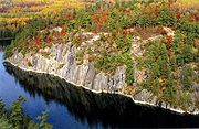
, with each of the four seasons having its own distinct characteristics. The areas near Lake Superior
Lake Superior
Lake Superior is the largest of the five traditionally-demarcated Great Lakes of North America. It is bounded to the north by the Canadian province of Ontario and the U.S. state of Minnesota, and to the south by the U.S. states of Wisconsin and Michigan. It is the largest freshwater lake in the...
in the Minnesota Arrowhead region
Iron Range
The Iron Range is a region that makes up the northeastern section of Minnesota in the United States. "The Range", as it is known by locals, is a region with multiple distinct bands of iron ore...
experience weather unique from the rest of the state. The moderating effect of Lake Superior keeps the surrounding area relatively cooler in the summer and relatively warmer in the winter, giving that region more of a maritime climate
Oceanic climate
An oceanic climate, also called marine west coast climate, maritime climate, Cascadian climate and British climate for Köppen climate classification Cfb and subtropical highland for Köppen Cfb or Cwb, is a type of climate typically found along the west coasts at the middle latitudes of some of the...
. On the Köppen climate classification
Köppen climate classification
The Köppen climate classification is one of the most widely used climate classification systems. It was first published by Crimea German climatologist Wladimir Köppen in 1884, with several later modifications by Köppen himself, notably in 1918 and 1936...
, the southern third of Minnesota—roughly from the Twin Cities region southward—falls in the hot summer humid continental climate
Humid continental climate
A humid continental climate is a climatic region typified by large seasonal temperature differences, with warm to hot summers and cold winters....
zone (Dfa), and the northern two-thirds of Minnesota falls in the warm summer humid continental climate zone (Dfb).
Winter in Minnesota is characterized by cold (below freezing) temperatures. Snow is the main form of winter precipitation, but freezing rain
Freezing rain
Freezing rain is the name given to rain that falls when surface temperatures are below freezing. The raindrops become supercooled while passing through a sub-freezing layer of air, many hundred feet , just above the surface, and then freeze upon impact with any object they encounter. The resulting...
, sleet
Ice pellets
Ice pellets are a form of precipitation consisting of small, translucent balls of ice. Ice pellets usually are smaller than hailstones. They often bounce when they hit the ground, and generally do not freeze into a solid mass unless mixed with freezing rain...
, and occasionally rain are all possible during the winter months. Common storm systems include Alberta clipper
Alberta clipper
An Alberta clipper is a fast moving low pressure area which generally affects the central provinces of Canada and parts of the Upper Midwest and Great Lakes regions of the United States. Most clippers occur between December and February, but can also occur occasionally in the month of November...
s or Panhandle hook
Panhandle hook
A Panhandle hook is a relatively infrequent storm system whose cyclogenesis occurs in the South to southwestern United States from the late fall through winter and into the early spring months...
s; some of which develop into blizzard
Blizzard
A blizzard is a severe snowstorm characterized by strong winds. By definition, the difference between blizzard and a snowstorm is the strength of the wind. To be a blizzard, a snow storm must have winds in excess of with blowing or drifting snow which reduces visibility to 400 meters or ¼ mile or...
s. Annual snowfall extremes have ranged from over 170 inches (432 cm) in the rugged Superior Highlands of the North Shore
North Shore (Lake Superior)
The North Shore of Lake Superior runs from Duluth, Minnesota, United States, at the southwestern end of the lake, to Thunder Bay and Nipigon, Ontario, Canada, in the north to Sault Ste. Marie, Ontario, in the east...
to as little as 10 inches (25 cm) in southern Minnesota. Temperatures as low as -60 °F have occurred during Minnesota winters. Spring is a time of major transition in Minnesota. Snowstorms
Winter storm
A winter storm is an event in which the dominant varieties of precipitation are formed that only occur at low temperatures, such as snow or sleet, or a rainstorm where ground temperatures are low enough to allow ice to form...
are common early in the spring, but by late-spring as temperatures begin to moderate the state can experience tornado outbreak
Tornado outbreak
While there is no single agreed upon definition, generally at least 6-10 tornadoes produced by the same synoptic scale weather system is considered a tornado outbreak. The tornadoes usually occur within the same day, or continue into the early morning hours of the succeeding day, and within the...
s, a risk which diminishes but does not cease through the summer and into the autumn.
In summer, heat and humidity predominate in the south, while warm and less humid conditions are generally present in the north. These humid conditions help kick off thunderstorm activity 30–40 days per year. Summer high temperatures in Minnesota average in the mid-80s F (30 °C) in the south to the upper-70s F (25 °C) in the north, with temperatures as hot as 114 °F (46 °C) possible. The growing season
Growing season
In botany, horticulture, and agriculture the growing season is the period of each year when native plants and ornamental plants grow; and when crops can be grown....
in Minnesota varies from 90 days per year in the Iron Range to 160 days in southeast Minnesota
Southeast Minnesota
Southeast Minnesota is the corner of Minnesota south of the Twin Cities metropolitan area extending east, and part of the multi-state area known as the Driftless Area. Rochester is the largest city in the area; other major cities include Winona, Owatonna, Faribault, Northfield, Austin, and Red...
. Tornado
Tornado
A tornado is a violent, dangerous, rotating column of air that is in contact with both the surface of the earth and a cumulonimbus cloud or, in rare cases, the base of a cumulus cloud. They are often referred to as a twister or a cyclone, although the word cyclone is used in meteorology in a wider...
es are possible in Minnesota from March through November, but the peak tornado month is June, followed by July, May, and August. The state averages 24 tornadoes per year. Minnesota is the driest state in the Midwest. Average annual precipitation across the state ranges from around 35 inches (889 mm) in the southeast to 20 inches (508 mm) in the northwest
Red River Valley
The Red River Valley is a region in central North America that is drained by the Red River of the North. It is significant in the geography of North Dakota, Minnesota, and Manitoba for its relatively fertile lands and the population centers of Fargo, Moorhead, Grand Forks, and Winnipeg...
. Autumn weather in Minnesota is largely the reverse of spring weather. The jet stream
Jet stream
Jet streams are fast flowing, narrow air currents found in the atmospheres of some planets, including Earth. The main jet streams are located near the tropopause, the transition between the troposphere and the stratosphere . The major jet streams on Earth are westerly winds...
—which tends to weaken in summer—begins to re-strengthen, leading to a quicker changing of weather patterns and an increased variability of temperatures. By late October and November these storm systems become strong enough to form major winter storms. Autumn and spring are the windiest times of the year in Minnesota.
General climatology
North America
North America is a continent wholly within the Northern Hemisphere and almost wholly within the Western Hemisphere. It is also considered a northern subcontinent of the Americas...
, Minnesota experiences temperature extremes characteristic of a continental climate, with cold winters and mild to hot summers in the south and frigid winters and generally cool summers in the north. Each season has distinctive upper air patterns which bring different weather conditions with them. The state is 1000 miles (1,609 km) from any large body of water (with the exception of Lake Superior), and temperatures and precipitation vary widely. It is far enough north to experience -60 °F temperatures and blizzards during the winter months, but far enough south to have 114 °F (46 °C) temperatures and tornado outbreaks in the summer. The 174 degree Fahrenheit (97 °C) variation between Minnesota's highest and lowest temperature is the 11th largest variation of any U.S. state
U.S. state
A U.S. state is any one of the 50 federated states of the United States of America that share sovereignty with the federal government. Because of this shared sovereignty, an American is a citizen both of the federal entity and of his or her state of domicile. Four states use the official title of...
, and 3rd largest of any non-mountainous state (behind North Dakota
North Dakota
North Dakota is a state located in the Midwestern region of the United States of America, along the Canadian border. The state is bordered by Canada to the north, Minnesota to the east, South Dakota to the south and Montana to the west. North Dakota is the 19th-largest state by area in the U.S....
and South Dakota
South Dakota
South Dakota is a state located in the Midwestern region of the United States. It is named after the Lakota and Dakota Sioux American Indian tribes. Once a part of Dakota Territory, South Dakota became a state on November 2, 1889. The state has an area of and an estimated population of just over...
).
Minnesota is far from major sources of moisture
Moisture
Humidity is the amount of moisture the air can hold before it rains. Moisture refers to the presence of a liquid, especially water, often in trace amounts...
and is in the transition zone between the moist East
Eastern United States
The Eastern United States, the American East, or simply the East is traditionally defined as the states east of the Mississippi River. The first two tiers of states west of the Mississippi have traditionally been considered part of the West, but can be included in the East today; usually in...
and the arid Great Plains
Great Plains
The Great Plains are a broad expanse of flat land, much of it covered in prairie, steppe and grassland, which lies west of the Mississippi River and east of the Rocky Mountains in the United States and Canada. This area covers parts of the U.S...
. Annual average precipitation
Precipitation (meteorology)
In meteorology, precipitation In meteorology, precipitation In meteorology, precipitation (also known as one of the classes of hydrometeors, which are atmospheric water phenomena is any product of the condensation of atmospheric water vapor that falls under gravity. The main forms of precipitation...
across the state ranges from around 35 inches (889 mm) in the southeast to 20 inches (508 mm) in the northwest. Snow is the main form of precipitation from November through March, while rain is the most common the rest of the year. Annual snowfall extremes have ranged from over 170 inches (432 cm) in the rugged Superior Highlands of the North Shore to as little as 2.3 inches (5.8 cm) in southern Minnesota. It has snowed in Minnesota during every month with the exception of July, and the state averages 110 days per year with snow cover of an inch (2.5 cm) or greater.
Lake Superior

Heat sink
A heat sink is a term for a component or assembly that transfers heat generated within a solid material to a fluid medium, such as air or a liquid. Examples of heat sinks are the heat exchangers used in refrigeration and air conditioning systems and the radiator in a car...
, keeping the state's North Shore area relatively cooler in the summer and warmer in the winter. While this effect is marked near the lake, it does not reach very far inland. For example, Grand Marais
Grand Marais, Minnesota
Grand Marais is a city in Cook County, Minnesota, United States. The population was 1,351 at the 2010 census. It is also the county seat of Cook County...
on the lakeshore has an average July high temperature of 70 °F (21 °C), while Virginia
Virginia, Minnesota
As of the census of 2000, there were 9,157 people, 4,333 households, and 2,270 families residing in the city. The population density was 486.1 people per square mile . There were 4,692 housing units at an average density of 249.1 per square mile...
, at about the same latitude but inland about 100 miles (161 km) to the west, has an average July high of 77 °F (25 °C). Conversely, Virginia's average high temperature in January is 15 °F (-9 °C), while Grand Marais' is 23 °F (-5 °C). Just a few miles inland from Lake Superior are the Sawtooth Mountains
Sawtooth Mountains (Minnesota)
The Sawtooth Mountains are a range of low, serrated ridges situated on the North Shore of Lake Superior in the U.S. state of Minnesota, extending about 30 miles from Carlton Peak near Tofte on the west, to Grand Marais on the east.-Description:...
, which almost completely confine the marine air masses and associated precipitation to lower elevations near the lake.
The prevailing northwest winter winds also limit the lake's influence. Places near the shoreline can receive lake-effect snow, but because the state lies north and west of the lake, snowfall amounts are not nearly as large as they are in locations like Wisconsin
Wisconsin
Wisconsin is a U.S. state located in the north-central United States and is part of the Midwest. It is bordered by Minnesota to the west, Iowa to the southwest, Illinois to the south, Lake Michigan to the east, Michigan to the northeast, and Lake Superior to the north. Wisconsin's capital is...
and Michigan
Michigan
Michigan is a U.S. state located in the Great Lakes Region of the United States of America. The name Michigan is the French form of the Ojibwa word mishigamaa, meaning "large water" or "large lake"....
that lie downwind to the south. Even so, the single largest snowstorm in Minnesota history was a lake effect event. On January 6, 1994, Finland, Minnesota, received 36 inches (91 cm) of lake effect snow in 24 hours, and 47 inches (119 cm) over a three day period. Both are Minnesota records. At 85 inches (216 cm) per year, the port city of Duluth
Duluth, Minnesota
Duluth is a port city in the U.S. state of Minnesota and is the county seat of Saint Louis County. The fourth largest city in Minnesota, Duluth had a total population of 86,265 in the 2010 census. Duluth is also the second largest city that is located on Lake Superior after Thunder Bay, Ontario,...
has the highest average snowfall total of any city in Minnesota. At 58.9 °F (14.9 °C), Grand Marais has the lowest average summer temperature of any city in the state.
The climatological effects of Lake Superior tend to stifle convection
Convection
Convection is the movement of molecules within fluids and rheids. It cannot take place in solids, since neither bulk current flows nor significant diffusion can take place in solids....
, thus limiting the potential for tornadoes. Although Cook
Cook County, Minnesota
Northern Minnesota offers extreme winter weather. While the averages are low, the extremes provide more details. A third of the year is below freezing . Of those days, 21 are below zero degrees Fahrenheit .-External links:...
and Lake
Lake County, Minnesota
Lake County is a county located in the U.S. state of Minnesota. As of 2010, the population was 10,866. Its county seat is Two Harbors. Lake County was founded on February 20, 1855, as Superior County, though its name was changed on March 3, of that year to St. Louis County. On March 1, 1856, St...
counties are two of the largest counties in the state, they have experienced only seven tornadoes in the past 56 years. One of those tornadoes was a large F3 that occurred in the 1969 Minnesota tornado outbreak
1969 Minnesota tornado outbreak
The 1969 Minnesota tornado outbreak was a tornado outbreak that affected portions of north central Minnesota on August 6, 1969. There were 13 confirmed tornadoes from the outbreak, 15 people were killed and 109 were injured.-Meteorological synopsis:...
.
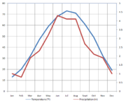
Temperature
| Jan | Feb | Mar | Apr | May | Jun | Jul | Aug | Sept | Oct | Nov | Dec | Annual | ||
| Alexandria Alexandria, Minnesota As of the census of 2000, there were 8,820 people, however the most recent count suggests a population upwards of 10,000, which is displayed on Alexandria's city limits signs. The census lists 4,047 households, and 2,011 families residing in the city. The population density was 992.5 people per... |
8 (−13) | 15 (−9) | 27 (−3) | 43 (6) | 56 (13) | 65 (18) | 70 (21) | 68 (20) | 58 (14) | 45 (7) | 28 (−2) | 14 (−10) | 41 (5) | |
| Brainerd Brainerd, Minnesota Brainerd is a city in Crow Wing County, Minnesota, United States. The population was 13,590 at the 2010 census. It is the county seat of Crow Wing County and one of the largest cities in Central Minnesota... |
6 (−14) | 13 (−11) | 26 (−3) | 42 (6) | 56 (13) | 64 (18) | 69 (21) | 66 (19) | 56 (13) | 44 (7) | 28 (−2) | 13 (−11) | 40 (4) | |
| Duluth Duluth, Minnesota Duluth is a port city in the U.S. state of Minnesota and is the county seat of Saint Louis County. The fourth largest city in Minnesota, Duluth had a total population of 86,265 in the 2010 census. Duluth is also the second largest city that is located on Lake Superior after Thunder Bay, Ontario,... |
10 (−12) | 17 (−8) | 26 (−3) | 39 (4) | 48 (9) | 58 (14) | 66 (19) | 65 (18) | 56 (13) | 45 (7) | 31 (−1) | 17 (−8) | 40 (4) | |
| Grand Marais | 14 (−10) | 19 (−7) | 28 (−2) | 38 (3) | 47 (8) | 53 (12) | 61 (16) | 63 (17) | 55 (13) | 45 (7) | 32 (0) | 19 (−7) | 39 (4) | |
| International Falls | 3 (−16) | 11 (−12) | 24 (−4) | 39 (4) | 53 (12) | 62 (17) | 66 (19) | 64 (18) | 53 (12) | 42 (6) | 24 (−4) | 9 (−13) | 32 (3) | |
| Redwood Falls Redwood Falls, Minnesota As of the census of 2000, there were 5,459 people, 2,266 households, and 1,389 families residing in the city. The population density was 1,167.1 people per square mile . There were 2,377 housing units at an average density of 508.2 per square mile... |
13 (−11) | 20 (−7) | 32 (−0) | 47 (8) | 60 (16) | 70 (21) | 74 (23) | 71 (22) | 62 (17) | 49 (9) | 32 (0) | 18 (−8) | 46 (8) | |
| Thief River Falls Thief River Falls, Minnesota As of the census of 2000, there were 8,410 people, 3,619 households, and 2,091 families residing in the city. The population density was 1,760.0 people per square mile . There were 3,931 housing units at an average density of 822.7 per square mile... |
3 (−16) | 11 (−12) | 24 (−4) | 42 (6) | 56 (13) | 64 (18) | 69 (21) | 67 (19) | 56 (13) | 44 (7) | 24 (−4) | 9 (−13) | 39 (4) | |
| Twin Cities | 13 (−11) | 20 (−7) | 32 (0) | 47 (8) | 59 (15) | 68 (20) | 73 (23) | 71 (22) | 61 (16) | 49 (9) | 32 (0) | 19 (−7) | 45 (7) | |
| Winona Winona, Minnesota Winona is a city in and the county seat of Winona County, in the U.S. State of Minnesota. Located in picturesque bluff country on the Mississippi River, its most noticeable physical landmark is Sugar Loaf.... |
18 (−8) | 24 (−4) | 36 (2) | 50 (10) | 62 (17) | 71 (22) | 76 (24) | 73 (23) | 64 (18) | 52 (11) | 32 (3) | 23 (−5) | 49 (9) | |
| Worthington Worthington, Minnesota Worthington is a city in Nobles County, Minnesota, United States. The population was 12,764 at the 2010 census. It is the county seat of Nobles County.The city's site was first settled in the 1870s as Okabena Station on a line of the Chicago, St... |
11 (−12) | 18 (−8) | 29 (−2) | 44 (7) | 57 (14) | 67 (19) | 71 (22) | 68 (20) | 59 (15) | 47 (8) | 30 (−1) | 17 (−8) | 43 (6) |
Precipitation
| Jan | Feb | Mar | Apr | May | Jun | Jul | Aug | Sept | Oct | Nov | Dec | Annual | |
| Alexandria | 1.0 (25) | 0.7 (18) | 1.5 (38) | 1.9 (48) | 3.0 (76) | 4.5 (112) | 3.3 (84) | 3.6 (91) | 2.7 (69) | 2.2 (56) | 1.2 (30) | 0.6 (15) | 26.0 (660) |
| Brainerd | 0.8 (20) | 0.6 (15) | 1.5 (38) | 2.0 (51) | 3.3 (84) | 4.2 (107) | 4.1 (104) | 3.6 (91) | 2.8 (71) | 2.5 (64) | 1.6 (41) | .7 (18) | 27.7 (704) |
| Duluth | 1.0 (25) | 0.5 (13) | 1.4 (36) | 1.6 (41) | 2.3 (58) | 3.7 (94) | 3.7 (94) | 3.7 (94) | 3.7 (94) | 1.9 (48) | 1.4 (36) | 0.8 (20) | 25.6 (650) |
| Grand Marais | 0.7 (18) | 0.6 (15) | 1.1 (28) | 1.3 (33) | 2.5 (64) | 3.4 (86) | 3.4 (86) | 3.1 (79) | 3.4 (86) | 2.6 (66) | 1.8 (46) | 0.8 (20) | 24.6 (625) |
| International Falls | 0.8 (20) | 0.6 (15) | 1.0 (25) | 1.4 (36) | 2.6 (66) | 4.0 (102) | 3.4 (86) | 3.1 (79) | 3.0 (76) | 2.0 (51) | 1.4 (36) | 0.7 (18) | 23.9 (607) |
| Redwood Falls | 0.7 (18) | 0.6 (15) | 1.7 (43) | 2.5 (64) | 3.1 (79) | 4.1 (104) | 3.8 (97) | 3.6 (91) | 2.5 (64) | 1.9 (48) | 1.6 (41) | 0.6 (15) | 26.6 (676) |
| Thief River Falls | 0.2 (5) | 0.3 (8) | 0.4 (10) | 1.0 (25) | 2.6 (66) | 3.4 (86) | 3.4 (86) | 3.1 (79) | 2.4 (61) | 1.7 (43) | 0.9 (23) | 0.3 (8) | 19.7 (500) |
| Twin Cities | 1.0 (25) | 0.8 (20) | 1.9 (48) | 2.3 (58) | 3.2 (81) | 4.3 (123) | 4.1 (104) | 4.1 (104) | 2.7 (69) | 2.1 (53) | 1.9 (48) | 1.0 (25) | 29.4 (747) |
| Winona | 1.4 (36) | 0.7 (18) | 1.8 (46) | 3.5 (89) | 3.9 (99) | 4.2 (107) | 4.4 (112) | 4.7 (119) | 3.9 (99) | 2.2 (56) | 2.2 (56) | 1.3 (33) | 34.2 (869) |
| Worthington | 0.7 (18) | 0.6 (15) | 1.9 (48) | 2.7 (69) | 3.4 (86) | 4.6 (117) | 3.6 (91) | 3.5 (89) | 2.6 (66) | 2.0 (51) | 1.7 (43) | 0.7 (18) | 27.8 (706) |
Winter
Even though winter does not officially start until late December, Minnesota usually begins experiencing winter-like conditions in November, sometimes as early as October. As with many other Midwestern states, winter in Minnesota is characterized by cold (below freezing) temperatures and snowfall. Weather systems can move in from the north, west, or south, with the majority of the weather being driven in from the north. A vigorous jet stream brings high and low-pressure systems through in quick succession, which can cause large temperature variations over a short period of time.Temperature
As the last remnants of summertime air in the southern U.S.Southern United States
The Southern United States—commonly referred to as the American South, Dixie, or simply the South—constitutes a large distinctive area in the southeastern and south-central United States...
start to lose their grip, cold polar air
Polar front
In meteorology, the polar front is the boundary between the polar cell and the Ferrel cell in each hemisphere. At this boundary a sharp gradient in temperature occurs between these two air masses, each at very different temperatures....
building up in northern Canada
Canada
Canada is a North American country consisting of ten provinces and three territories. Located in the northern part of the continent, it extends from the Atlantic Ocean in the east to the Pacific Ocean in the west, and northward into the Arctic Ocean...
starts to push farther south, eventually spreading into Minnesota. By the time December and January arrive, Minnesota is fully engulfed in the polar air and is then subjected to outbreaks of arctic
Arctic
The Arctic is a region located at the northern-most part of the Earth. The Arctic consists of the Arctic Ocean and parts of Canada, Russia, Greenland, the United States, Norway, Sweden, Finland, and Iceland. The Arctic region consists of a vast, ice-covered ocean, surrounded by treeless permafrost...
air mass
Air mass
In meteorology, an air mass is a volume of air defined by its temperature and water vapor content. Air masses cover many hundreds or thousands of square miles, and adopt the characteristics of the surface below them. They are classified according to latitude and their continental or maritime...
es. Because there are no natural barriers north or northwest of Minnesota to block arctic air from pouring south, Minnesota gets regular shots of the arctic air through the winter. High pressure system
High pressure area
A high-pressure area is a region where the atmospheric pressure at the surface of the planet is greater than its surrounding environment. Winds within high-pressure areas flow outward due to the higher density air near their center and friction with land...
s which descend south from the Canadian plains behind the fronts bring light winds
WINDS
WINDS , is a Japanese communication satellite. Launch was originally scheduled for 2007. The launch date was eventually set for 15 February 2008, however a problem detected in a second stage manoeuvring thruster delayed it to 23 February...
, clear skies, and bitterly cold temperatures. The northern part of Minnesota gets the brunt of the cold air. International Falls
International Falls, Minnesota
International Falls is a city in and the county seat of Koochiching County, Minnesota, United States. The population was 6,424 at the 2010 census....
, sometimes called the "Icebox of the nation", has the coldest average annual temperature of any National Weather Service
National Weather Service
The National Weather Service , once known as the Weather Bureau, is one of the six scientific agencies that make up the National Oceanic and Atmospheric Administration of the United States government...
first-order station
Weather station
A weather station is a facility, either on land or sea, with instruments and equipment for observing atmospheric conditions to provide information for weather forecasts and to study the weather and climate. The measurements taken include temperature, barometric pressure, humidity, wind speed, wind...
in the contiguous United States at 37.4 °F (3 °C). Tower, Minnesota
Tower, Minnesota
As of the census of 2000, there are 479 people in the city, organized into 233 households and 137 families. The population density is 176.8 people per square mile . There are 295 housing units at an average density of 108.9 per square mile...
, sinks below zero (−17 °C) an average of 71 times per year, and the ten coldest counties in the country, based on January minimums, are all located in Minnesota. The air mass then slowly moderates as it moves south into the rest of the state. Alberta clippers alternate with these high-pressure systems, bringing high winds and some snowfall with them.

Zonal flow
Zonal flow is a meteorological term meaning that the general flow pattern is west to east, or east to west, along the Earth's latitude lines . Extratropical cyclones in this environment tend to be weaker, moving faster and producing relatively little impact on local weather.-References:**...
takes hold. This means that the jet stream will move in a west to east motion—rather than north to south—and warmer air from the western United States is pushed into the region. In Minnesota this pattern commonly leads to a prolonged period of above freezing high temperatures that gives Minnesotans a break from the winter freeze. Storms that move into Minnesota from a more westerly direction generally do not bring significant amounts of precipitation with them.
Precipitation
Winter precipitation comes in a few different forms. Snow is the main form of precipitation, but freezing rain, ice, sleet and sometimes even rain are all possible during the winter months. Larger storm systems, often Panhandle hooks or other storms that occur with a meridional flowMeridional flow
Meridional flow is a meteorological term meaning that the general flow pattern is north to south, or south to north, along the Earth's longitude lines . Extratropical cyclones in this environment tend to be stronger and move slower...
, can bring large amounts of snow and even blizzard conditions.
Alberta clippers

Saskatchewan
Saskatchewan is a prairie province in Canada, which has an area of . Saskatchewan is bordered on the west by Alberta, on the north by the Northwest Territories, on the east by Manitoba, and on the south by the U.S. states of Montana and North Dakota....
Screamers" or "Manitoba
Manitoba
Manitoba is a Canadian prairie province with an area of . The province has over 110,000 lakes and has a largely continental climate because of its flat topography. Agriculture, mostly concentrated in the fertile southern and western parts of the province, is vital to the province's economy; other...
Maulers".) Although clippers often originate over the northern Pacific Ocean, they lose most of their moisture through orographic lift
Orographic lift
Orographic lift occurs when an air mass is forced from a low elevation to a higher elevation as it moves over rising terrain. As the air mass gains altitude it quickly cools down adiabatically, which can raise the relative humidity to 100% and create clouds and, under the right conditions,...
when they collide with the Canadian Rockies
Canadian Rockies
The Canadian Rockies comprise the Canadian segment of the North American Rocky Mountains range. They are the eastern part of the Canadian Cordillera, extending from the Interior Plains of Alberta to the Rocky Mountain Trench of British Columbia. The southern end borders Idaho and Montana of the USA...
. Because of the limited moisture content and quick movement of the systems, clippers rarely produce more than 6 in (15 cm) of snow as they pass through Minnesota. The biggest effects of an Alberta Clipper are what follows them, and that is arctic air, high wind speed, and dangerous wind chill
Wind chill
Wind chill is the felt air temperature on exposed skin due to wind. The wind chill temperature is always lower than the air temperature, and the windchill is undefined at the higher temps...
s. This often results in severe blowing and drifting snow, and sometimes even blizzard conditions. Alberta Clippers often proceed to become copious lake-effect snow producers on the southern and eastern shores of the Great Lakes
Great Lakes
The Great Lakes are a collection of freshwater lakes located in northeastern North America, on the Canada – United States border. Consisting of Lakes Superior, Michigan, Huron, Erie, and Ontario, they form the largest group of freshwater lakes on Earth by total surface, coming in second by volume...
.
Panhandle hooks
In terms of their characteristics, Panhandle hooks are nearly the opposite of Alberta clippers. Instead of forming in the north and dropping south, these low pressure systems form in the southwestern United StatesSouthwestern United States
The Southwestern United States is a region defined in different ways by different sources. Broad definitions include nearly a quarter of the United States, including Arizona, California, Colorado, Nevada, New Mexico, Oklahoma, Texas and Utah...
and then move northeast. They get their name from the location where they usually make their turn to the north; near the panhandles of Oklahoma
Oklahoma Panhandle
The Oklahoma Panhandle is the extreme western region of the state of Oklahoma, comprising Cimarron County, Texas County, and Beaver County. Its name comes from the similarity of shape to the handle of a cooking pan....
and Texas
Texas Panhandle
The Texas Panhandle is a region of the U.S. state of Texas consisting of the northernmost 26 counties in the state. The panhandle is a rectangular area bordered by New Mexico to the west and Oklahoma to the north and east...
. Unlike clippers, these storms usually have a great deal of moisture to work with. As the storms make their turn to the north, they pull in moist air from the nearby Gulf of Mexico
Gulf of Mexico
The Gulf of Mexico is a partially landlocked ocean basin largely surrounded by the North American continent and the island of Cuba. It is bounded on the northeast, north and northwest by the Gulf Coast of the United States, on the southwest and south by Mexico, and on the southeast by Cuba. In...
and pull it northward toward Minnesota and other parts of the Midwest. As these systems move to the northeast, there will usually be a heavy band of snow to the northwest of the low pressure center if there is enough cold air present. A wintery mix of precipitation, rain, or sometimes even thunderstorms will then often occur to the south of it. Snowfall over a foot (30 cm) is not uncommon with a panhandle hook, and because of the high moisture content in these systems the snow is usually wet and heavy. Large panhandle hooks can become powerful enough to draw in arctic air after they pass by the state, leaving bitter cold temperatures and wind chills in their wake. Panhandle Hooks are responsible for some of the most famous blizzards that have occurred in the Midwest, including the Great Storm of 1975
Great Storm of 1975
The Great Storm of 1975 was an intense storm system that impacted a large portion of the Central and Southeast United States from January 9 to January 12, 1975. The storm produced 45 tornadoes in the Southeast U.S...
.
Spring

Severe weather
Severe weather phenomena are weather conditions that are hazardous to human life and property.- Examples Include :Severe weather can occur under a variety of situations, but three characteristics are generally needed: a temperature or moisture boundary, moisture, and , instability in the...
since the warm air needed for it has not yet pushed that far to the north. Early spring tornado outbreaks do occur occasionally in Minnesota though, as evidenced by the 1998 Comfrey – St. Peter tornado outbreak on March 29, 1998. More often, Minnesota is on the northern (cooler) side of major storm systems in the early spring, which instead results in only rain and possibly snow. Even though the winter snow pack typically starts to melt in southern Minnesota in early March, there is usually still enough cold air present over Canada to allow for major snow storms in Minnesota until late April.

Wind
With the exception of areas along the shores of Lake Superior, winds in Minnesota generally prevail from the north and northwest in the winter, and south and southeast in the summer. On average, autumn and spring are the windiest times of the year in Minnesota. October is the windiest month in northwest Minnesota, while April is the windiest over the rest of the state. Winds generally average between 9–11 mph (14–18 km/h) across the state, with one major exception. The heaviest winds in the state are found on the Buffalo RidgeBuffalo Ridge
Buffalo Ridge is a large expanse of rolling hills in the southeastern part of the larger Coteau des Prairies. It stands 1,995 feet above sea level. The Buffalo Ridge is sixty miles long and runs through Lincoln County, Pipestone County, Murray County, and Nobles County in the southwest...
, or Coteau des Prairies
Coteau des Prairies
The Coteau des Prairies is a plateau approximately 200 miles in length and 100 miles in width , rising from the prairie flatlands in eastern South Dakota, southwestern Minnesota, and northwestern Iowa in the United States...
, a flatiron-shaped
Iron (appliance)
A clothes iron, also referred to as simply an iron, is a small appliance used in ironing to remove wrinkles from fabric.Ironing works by loosening the ties between the long chains of molecules that exist in polymer fiber materials. With the heat and the weight of the ironing plate, the fibers are...
area extending from Watertown, South Dakota
Watertown, South Dakota
Watertown is a city in and the county seat of Codington County, South Dakota, United States. The population was 21,482 at the 2010 census. It is also the principal city of the Watertown Micropolitan Statistical Area, which includes all of Codington and Hamlin counties...
, diagonally across southwestern Minnesota and into Iowa
Iowa
Iowa is a state located in the Midwestern United States, an area often referred to as the "American Heartland". It derives its name from the Ioway people, one of the many American Indian tribes that occupied the state at the time of European exploration. Iowa was a part of the French colony of New...
. Created by two lobes of a glacier
Glacier
A glacier is a large persistent body of ice that forms where the accumulation of snow exceeds its ablation over many years, often centuries. At least 0.1 km² in area and 50 m thick, but often much larger, a glacier slowly deforms and flows due to stresses induced by its weight...
parting around a pre-existing plateau
Plateau
In geology and earth science, a plateau , also called a high plain or tableland, is an area of highland, usually consisting of relatively flat terrain. A highly eroded plateau is called a dissected plateau...
during the (Pleistocene
Pleistocene
The Pleistocene is the epoch from 2,588,000 to 11,700 years BP that spans the world's recent period of repeated glaciations. The name pleistocene is derived from the Greek and ....
) Ice Age
Ice age
An ice age or, more precisely, glacial age, is a generic geological period of long-term reduction in the temperature of the Earth's surface and atmosphere, resulting in the presence or expansion of continental ice sheets, polar ice sheets and alpine glaciers...
, the Buffalo Ridge is ideal for wind power
Wind power
Wind power is the conversion of wind energy into a useful form of energy, such as using wind turbines to make electricity, windmills for mechanical power, windpumps for water pumping or drainage, or sails to propel ships....
generation, with average wind speeds of 16.1 mph (26.8 km/h).
Floods
Flood
A flood is an overflow of an expanse of water that submerges land. The EU Floods directive defines a flood as a temporary covering by water of land not normally covered by water...
ing in its major rivers by spring snowmelt runoff
Surface runoff
Surface runoff is the water flow that occurs when soil is infiltrated to full capacity and excess water from rain, meltwater, or other sources flows over the land. This is a major component of the water cycle. Runoff that occurs on surfaces before reaching a channel is also called a nonpoint source...
and ice jams
Ice dam
An ice dam occurs when water builds up behind a blockage of ice. Ice dams can occur in various ways.-Caused by a glacier:Sometimes a glacier flows down a valley to a confluence where the other branch carries an unfrozen river...
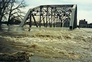
. Spring flooding to some degree occurs almost annually on some Minnesota rivers, but major floods have occurred in 1965, 1969, 1997, 2001, and 2009. The flooding in 1965 was the worst flood in Minnesota history on the Mississippi River
Mississippi River
The Mississippi River is the largest river system in North America. Flowing entirely in the United States, this river rises in western Minnesota and meanders slowly southwards for to the Mississippi River Delta at the Gulf of Mexico. With its many tributaries, the Mississippi's watershed drains...
, while the flooding in 1997 was the worst in history on the Red River
Red River of the North
The Red River is a North American river. Originating at the confluence of the Bois de Sioux and Otter Tail rivers in the United States, it flows northward through the Red River Valley and forms the border between the U.S. states of Minnesota and North Dakota before continuing into Manitoba, Canada...
. The Red River flood of 1997 was aided heavily by the 11 blizzards that struck Minnesota that winter. Besides heavy winter and spring snowfall, cold winter temperatures and heavy autumn and spring rains causing sudden run-off surges are also common causes of spring river flooding in Minnesota.
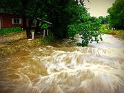
Minnesota is also prone to both river flooding and localized flash flooding by extended periods of heavy late-spring and summer rainfall. The Great Flood of 1993
Great Flood of 1993
The Great Mississippi and Missouri Rivers Flood of 1993 occurred in the American Midwest, along the Mississippi and Missouri rivers and their tributaries, from April to October 1993. The flood was among the most costly and devastating to ever occur in the United States, with $15 billion in damages...
on the Mississippi River was caused by copious amounts of rain that fell after the spring snow melt.
The 2007 Midwest flooding
2007 Midwest flooding
The 2007 Midwest flooding was a major flooding event that occurred in the Midwestern United States in the third week of August 2007. While Hurricane Dean was affecting the Yucatán Peninsula and the Gulf of Mexico, and Tropical Storm Erin was affecting Oklahoma and Texas, a persistent storm system...
, which affected the hilly Driftless area of southeast Minnesota was the result of a training
Training (meteorology)
In meteorology, training denotes repeated areas of rain, typically associated with thunderstorms, that move over the same region in a relatively short period of time. Training thunderstorms are capable of producing excessive rainfall totals, often causing flash flooding...
pattern of storms mixing warm moist air from Tropical Storm Erin
Tropical Storm Erin (2007)
Tropical Storm Erin was the second tropical cyclone to make landfall in the United States in the 2007 Atlantic hurricane season. The fifth named storm of the season, it formed in the Gulf of Mexico on August 14 from a persistent area of convection...
with cooler Canadian air, resulting in record 24-hour rainfall totals of up to 17 inches (432 mm), with a similar flooding event in 2010 as a result of the remnants of tropical storm Georgette
Tropical Storm Georgette (2010)
Tropical Storm Georgette was a short-lived tropical storm that struck the Baja California Sur in September 2010. Georgette originated from an area of disturbed weather over the eastern Pacific on September 20. The next day, the system was upgraded into a tropical storm a short distance south...
in the eastern Pacific and Hurricane Karl in the Gulf of Mexico
Gulf of Mexico
The Gulf of Mexico is a partially landlocked ocean basin largely surrounded by the North American continent and the island of Cuba. It is bounded on the northeast, north and northwest by the Gulf Coast of the United States, on the southwest and south by Mexico, and on the southeast by Cuba. In...
.
Summer

Temperature

Surface weather analysis
Surface weather analysis is a special type of weather map that provides a view of weather elements over a geographical area at a specified time based on information from ground-based weather stations...
dropping south from Canada. The polar air typically does not stick around very long though and is quickly replaced by the warmer and more humid air from the Gulf of Mexico once again. The cool, dry polar air colliding with hot and humid summertime air keep the threat of thunderstorms and tornadoes around in Minnesota through July and August. Northern Minnesota is considerably cooler and less humid than southern Minnesota during the summer months. For example, Duluth's annual average temperature and dew point are 6 degrees (3.4 °C) cooler than Minneapolis'.
July is the hottest month in Minnesota state-wide and is usually the month when the peak heat wave
Heat wave
A heat wave is a prolonged period of excessively hot weather, which may be accompanied by high humidity. There is no universal definition of a heat wave; the term is relative to the usual weather in the area...
s occur. In July 1936, Minnesota and the rest of the Midwest suffered through its most severe heat wave on record. Most of the state was engulfed in 100 °F (38 °C) temperatures for several days in a row, and Minnesota's all time record high temperature of 114 °F (46 °C) was tied during this stretch. This heat wave was also responsible for setting the Twin Cities' all time record high of 108 °F (42 °C), as well as the all time record high of several other cities across the state.
The region of Minnesota that experiences the hottest summer temperatures is the west. Coteau des Prairies can heat cities to the north of it similar to how places in the Rocky Mountains
Rocky Mountains
The Rocky Mountains are a major mountain range in western North America. The Rocky Mountains stretch more than from the northernmost part of British Columbia, in western Canada, to New Mexico, in the southwestern United States...
are warmed by Chinook wind
Chinook wind
Chinook winds , often called chinooks, commonly refers to foehn winds in the interior West of North America, where the Canadian Prairies and Great Plains meet various mountain ranges, although the original usage is in reference to wet, warm coastal winds in the Pacific Northwest.Chinook is claimed...
s. As southwest winds blow down the slope of Coteau des Prairies, the air compresses and warms
Adiabatic process
In thermodynamics, an adiabatic process or an isocaloric process is a thermodynamic process in which the net heat transfer to or from the working fluid is zero. Such a process can occur if the container of the system has thermally-insulated walls or the process happens in an extremely short time,...
. This makes the already hot air even hotter and often causes places like Beardsley
Beardsley, Minnesota
Beardsley is a city in Big Stone County, Minnesota, United States. The population was 233 at the 2010 census.Beardsley holds two state monthly record high temperatures, 111°F in September, set in 1931, and 98°F Beardsley is a city in Big Stone County, Minnesota, United States. The population was...
and Moorhead
Moorhead, Minnesota
Moorhead is a city in Clay County, Minnesota, United States, and the largest city in northwest Minnesota. The population was 38,065 at the 2010 Census. It is the county seat of Clay County....
to record the warmest temperature in the state, despite their higher latitudes.
Precipitation
Hail
Hail is a form of solid precipitation. It consists of balls or irregular lumps of ice, each of which is referred to as a hail stone. Hail stones on Earth consist mostly of water ice and measure between and in diameter, with the larger stones coming from severe thunderstorms...
, strong tornadoes, and large bow echo
Bow echo
A bow echo is a term describing the characteristic radar return from a mesoscale convective system that is shaped like an archer’s bow. These systems can produce severe straight-line winds and occasionally tornadoes, causing major damage.-Research:...
s that result in damaging straight-line winds
Downburst
A downburst is created by an area of significantly rain-cooled air that, after reaching ground level, spreads out in all directions producing strong winds. Unlike winds in a tornado, winds in a downburst are directed outwards from the point where it hits land or water...
. Minnesota has experienced several major derecho
Derecho
A derecho is a widespread and long-lived, violent convectively induced straight-line windstorm that is associated with a fast-moving band of severe thunderstorms in the form of a squall line usually taking the form of a bow echo...
events, most recently the Boundary Waters-Canadian Derecho
Boundary Waters-Canadian Derecho
The Boundary Waters – Canadian Derecho, , was an international derecho that occurred during the afternoon and evening hours of July 4 and the early morning hours of July 5, 1999. It traveled and lasted 22 hours.-North Dakota:In the pre-dawn hours of July 4, a band of thunderstorms developed...
which blew down millions of trees in the Boundary Waters Canoe Area Wilderness
Boundary Waters Canoe Area Wilderness
The Boundary Waters Canoe Area Wilderness , is a wilderness area within the Superior National Forest in northeastern Minnesota under the administration of the U.S. Forest Service...
on July 4, 1999.
Summertime thunderstorms are fueled by dew point
Dew point
The dew point is the temperature to which a given parcel of humid air must be cooled, at constant barometric pressure, for water vapor to condense into liquid water. The condensed water is called dew when it forms on a solid surface. The dew point is a saturation temperature.The dew point is...
s that often reach into the 70s °F (21 °C) and sometimes even 80 °F (27 °C). In addition to severe conditions, thunderstorms produce heavy rain and cloud to ground lightning
Lightning
Lightning is an atmospheric electrostatic discharge accompanied by thunder, which typically occurs during thunderstorms, and sometimes during volcanic eruptions or dust storms...
. Heavy rain brings flash flood
Flash flood
A flash flood is a rapid flooding of geomorphic low-lying areas—washes, rivers, dry lakes and basins. It may be caused by heavy rain associated with a storm, hurricane, or tropical storm or meltwater from ice or snow flowing over ice sheets or snowfields...
s to Minnesota an average of three days per year. With the exception of hail, summer precipitation in Minnesota is almost always in the form of rain. The lone exception is in far northern Minnesota, where in mid-September, small amounts of snow become a possibility.
Droughts
DroughtDrought
A drought is an extended period of months or years when a region notes a deficiency in its water supply. Generally, this occurs when a region receives consistently below average precipitation. It can have a substantial impact on the ecosystem and agriculture of the affected region...
s are an annual summer concern in Minnesota, especially for farmer
Farmer
A farmer is a person engaged in agriculture, who raises living organisms for food or raw materials, generally including livestock husbandry and growing crops, such as produce and grain...
s. The growing season (which varies from 90 days per year in the Iron Range to 160 days in southeast Minnesota) is when Minnesota averages its highest percentage of annual precipitation, so a lack of rainfall during this time period can be devastating to crops. The last major drought in Minnesota was in 1988
US Drought of 1988
The US Drought of 1988 was one of the worst droughts in US history. It was a multi-year drought which began in 1988 and continued into 1989. The drought caused $60 billion in damage...
. During that year, the period of April–July was the 2nd driest in the previous century, and the period of May–August was the hottest on record. The combination of dry skies and heat caused a severe drought which cost the state approximately 1.2 billion dollars in crop losses.
Other memorable drought years were 1976 and the Dust Bowl
Dust Bowl
The Dust Bowl, or the Dirty Thirties, was a period of severe dust storms causing major ecological and agricultural damage to American and Canadian prairie lands from 1930 to 1936...
years of the 1930s. During the dust bowl, inappropriate farming techniques enhanced by years of drought conditions led to dust storm
Dust storm
A dust / sand storm is a meteorological phenomenon common in arid and semi-arid regions. Dust storms arise when a gust front or other strong wind blows loose sand and dirt from a dry surface. Particles are transported by saltation and suspension, causing soil to move from one place and deposition...
s in Minnesota and the other parts of the Midwest. Drought conditions also have helped spawn forest fires. In 1894 the Great Hinckley Fire
Great Hinckley Fire
The Great Hinckley Fire was a major conflagration on September 1, 1894, which burned an area of at least 810 km² , perhaps more than 1000 km², including the town of Hinckley, Minnesota. The fire killed hundreds, with the minimum number estimated at 418. However, some scholars believe the...
destroyed Hinckley
Hinckley, Minnesota
As of the census of 2000, there were 1,291 people, 551 households, and 332 families residing in the city. The population density was 454.3 people per square mile . There were 614 housing units at an average density of 216.0 per square mile...
killing an estimated 459 people, and in 1918 a forest fire
1918 Cloquet Fire
The 1918 Cloquet fire was a massive fire in northern Minnesota in October, 1918 caused by sparks on the local railroads and dry conditions. The fire left much of western Carlton County devastated, mostly affecting Moose Lake, Cloquet, and Kettle River. Cloquet was hit the hardest by the fires...
killed 453 people in the vicinity of Cloquet
Cloquet, Minnesota
As of the census of 2000, there were 11,201 people, 4,636 households, and 2,967 families residing in the city. The population density was 317.9 people per square mile . There were 4,805 housing units at an average density of 136.4 per square mile...
. More recently, in 2006, the Cavity Lake Fire burned 31,830 acres (129 km²) in the Boundary Waters Canoe Area Wilderness.
Tornadoes

Tornado Alley
Tornado Alley is a colloquial and popular media term that most often refers to the area of the United States where tornadoes are most frequent. Although an official location is not defined, the area between the Rocky Mountains and Appalachian Mountains is usually associated with it.The areas...
. Just over a third of tornadoes in Minnesota strike between 4:00 pm–6:00 pm. The state averages 24 tornadoes per year; 99% of which have ratings of F2
Fujita scale
The Fujita scale , or Fujita-Pearson scale, is a scale for rating tornado intensity, based primarily on the damage tornadoes inflict on human-built structures and vegetation...
or weaker. On average Minnesota has an F5 tornado once every 25 years. Some of the notable Minnesota tornadoes and outbreaks are:
- August 21, 1883: An F5 tornado struck Rochester1883 Rochester TornadoThe 1883 Rochester tornado was an F5 tornado that hit Rochester, Minnesota on August 21, 1883. It was one in a series of tornadoes that hit Southeast Minnesota that day, causing at least 37 deaths and over 200 injuries, and was the impetus for the creation of the Mayo Clinic. On July 21, two...
, killing 37. This tornado led to the construction of a new hospital, which eventually evolved into the Mayo ClinicMayo ClinicMayo Clinic is a not-for-profit medical practice and medical research group specializing in treating difficult patients . Patients are referred to Mayo Clinic from across the U.S. and the world, and it is known for innovative and effective treatments. Mayo Clinic is known for being at the top of...
. - April 14, 1886: A large tornado struck Sauk Rapids1886 Sauk Rapids tornadoThe 1886 Sauk Rapids Tornado was a tornado that tore through the cities of Sauk Rapids, St. Cloud, and Rice, Minnesota on April 14, 1886. It destroyed much of the town of Sauk Rapids and killed 72 people along its path. It is Minnesota's deadliest tornado on record...
, killing 72. This was Minnesota's deadliest tornado on record. - June 22, 1919: The second-deadliest tornado1919 Fergus Falls tornadoThe 1919 Fergus Falls tornado was a large and destructive tornado that struck Fergus Falls, Minnesota on June 22, 1919. It killed 57 people and is the second deadliest tornado in Minnesota's history. This tornado occurred just 10 months after a tornado in Tyler, Minnesota killed 36 people...
in Minnesota history tore through Fergus FallsFergus Falls, MinnesotaFergus Falls is a city in and the county seat of Otter Tail County, Minnesota, United States. The population was 13,138 at the 2010 census.-Today:...
, killing 59. - May 6, 1965: Four F4 tornadoes ripped through the Twin Cities metro area (two of them in FridleyFridley, MinnesotaAs of the census of 2000, there were 27,449 people, 11,328 households, and 7,317 families residing in the city. The population density was 2,701.3 people per square mile . There were 11,504 housing units at an average density of 1,132.1 per square mile...
), killing 13. - June 16, 1992: Minnesota experienced its second-largest tornado outbreakMid-June 1992 Tornado OutbreakThe Mid-June 1992 tornado outbreak was a one of the largest tornado outbreaks on record, affecting portions of the Central United States from June 14 to June 18, 1992. The outbreak began on June 14 when six tornadoes touched down in Colorado and Idaho...
with 27 recorded twisters. The largest tornado in this family was an F5 that struck Chandler, MinnesotaChandler, MinnesotaAs of the census of 2000, there were 276 people, 113 households, and 72 families residing in the city. The population density was 342.7 people per square mile . There were 121 housing units at an average density of 150.2 per square mile . The racial makeup of the city was 97.46% White, 1.81%...
, killing one. This is the most recent F5 tornado to strike the state. - March 29, 1998: An F4 and an F3 tornado that were part of a larger outbreak tore through the towns of ComfreyComfrey, MinnesotaFor the plant, see ComfreyComfrey is a city in Brown and Cottonwood counties in the U.S. state of Minnesota. The population was 382 at the 2010 census...
and St. PeterSt. Peter, MinnesotaSt. Peter is a city in Nicollet County, Minnesota, United States. The population was 11,196 at the 2010 census. It is the county seat of Nicollet County.St...
. They killed two and caused damage in the millions of dollars in Minnesota's earliest recorded tornado outbreak. - June 17, 2010: Three EF4 and six EF3 tornadoes were part of 48 twisters that touched down in Minnesota's largest tornado outbreak on recordMid-June 2010 tornado outbreak-June 16 event:-June 17 event:-June 18 event:-Wadena supercell:Around 3:20 p.m. CDT , a supercell thunderstorm developed over Stevens County, Minnesota and initially tracked north-northeastward before turning fully northeast...
.
Autumn
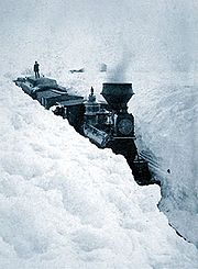
Armistice Day Blizzard
The Armistice Day Blizzard took place in the Midwest region of the United States on 11 November and 12 November 1940...
. Temperatures in the 60s °F (16 °C) on the morning of November 11 dropped into the single digits (below –12 °C) by the morning of November 12, bringing with them 27 inches (69 cm) of snow and 60 mph (100 km/h) winds. Known deaths in this blizzard reached 154, 49 of them in Minnesota. On October 31, 1991, much of Minnesota was hit by the Halloween Blizzard
Halloween Blizzard
The Halloween Blizzard was a period of heavy snowfall and ice accumulation that affected parts of the Upper Midwest of the United States, from October 31 to November 3, 1991...
. A band of snowfall of 24+ in (60+ cm) fell from the Twin Cities north to Duluth. It was the single largest snowfall ever recorded in many communities across eastern Minnesota.
Image and popular culture
.jpg)
"Summer at the lake" is a Minnesota tradition. Water skiing
Water skiing
thumb|right|A slalom skier making a turn on a slalom waterski.Waterskiing is a sport where an individual is pulled behind a boat or a cable ski installation on a body of water, skimming the surface.-History:...
was invented in Minnesota by Ralph Samuelson
Ralph Samuelson
Ralph Wilford Samuelson was the inventor of water skiing, which he first performed in the summer of 1922 in Lake City, Minnesota, just before his 19th birthday. Samuelson was already skilled at aquaplaning—standing on a board while being pulled by a powerboat—but he hoped to create something like...
, and the Minneapolis Aquatennial features a milk carton boat race. Contestants build boats from milk cartons
Carton
Carton is the name of certain types of containers typically made from paperboard which is also sometimes known as cardboard. Many types of cartons are used in packaging. Sometimes a carton is also called a box.-Folding cartons:...
and float them on Minneapolis area lakes, with recognition based more on colorful and imaginative designs than on actual racing performance.
But while Minnesota's warm summers provide its natives and tourists with a variety of outdoor activities, the state is known for its winters. The state has produced curlers
Curling
Curling is a sport in which players slide stones across a sheet of ice towards a target area. It is related to bowls, boule and shuffleboard. Two teams, each of four players, take turns sliding heavy, polished granite stones, also called "rocks", across the ice curling sheet towards the house, a...
, skiers
Skiing
Skiing is a recreational activity using skis as equipment for traveling over snow. Skis are used in conjunction with boots that connect to the ski with use of a binding....
, and luge
Luge
A Luge is a small one- or two-person sled on which one sleds supine and feet-first. Steering is done by flexing the sled's runners with the calf of each leg or exerting opposite shoulder pressure to the seat. Racing sleds weigh 21-25 kilograms for singles and 25-30 kilograms for doubles. Luge...
rs who have competed in the Winter Olympics
Winter Olympic Games
The Winter Olympic Games is a sporting event, which occurs every four years. The first celebration of the Winter Olympics was held in Chamonix, France, in 1924. The original sports were alpine and cross-country skiing, figure skating, ice hockey, Nordic combined, ski jumping and speed skating...
, pioneers who invented the snowmobile
Snowmobile
A snowmobile, also known in some places as a snowmachine, or sled,is a land vehicle for winter travel on snow. Designed to be operated on snow and ice, they require no road or trail. Design variations enable some machines to operate in deep snow or forests; most are used on open terrain, including...
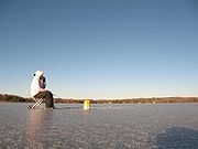
, and legions of ice fishing
Ice fishing
Ice fishing is the practice of catching fish with lines and fish hooks or spears through an opening in the ice on a frozen body of water. Ice anglers may sit on the stool in the open on a frozen lake, or in a heated cabin on the ice, some with bunks and amenities.-Locations:It is a popular pastime...
enthusiasts.
Ice hockey
Ice hockey, often referred to as hockey, is a team sport played on ice, in which skaters use wooden or composite sticks to shoot a hard rubber puck into their opponent's net. The game is played between two teams of six players each. Five members of each team skate up and down the ice trying to take...
players, both at the amateur and professional levels. Eveleth, Minnesota
Eveleth, Minnesota
As of the census of 2000, there were 3,865 people, 1,717 households, and 971 families residing in the city. The population density was 611.0 people per square mile . There were 1,965 housing units at an average density of 310.6 per square mile...
, home to the United States Hockey Hall of Fame
United States Hockey Hall of Fame
The United States Hockey Hall of Fame was established in 1973 with the goal of preserving the rich history of the game in the United States while recognizing the extraordinary contributions of select players, coaches, administrators, officials and teams....
, boasts of the number of quality players and the contributions of the city (and the rest of the Mesabi Range
Mesabi Range
The Mesabi Iron Range is a vast deposit of iron ore and the largest of four major iron ranges in the region collectively known as the Iron Range of Minnesota. Discovered in 1866, it is the chief deposit of iron ore in the United States. The deposit is located in northeast Minnesota, largely in...
) to the growth and development of hockey in the United States.
To many outsiders, Minnesota's winters appear to be cold and inhospitable. A World War II
World War II
World War II, or the Second World War , was a global conflict lasting from 1939 to 1945, involving most of the world's nations—including all of the great powers—eventually forming two opposing military alliances: the Allies and the Axis...
newscaster, in describing the brutally cold conditions of the Russian front, stated that at least Minnesotans could understand it. A New York journalist visited St. Paul
Saint Paul, Minnesota
Saint Paul is the capital and second-most populous city of the U.S. state of Minnesota. The city lies mostly on the east bank of the Mississippi River in the area surrounding its point of confluence with the Minnesota River, and adjoins Minneapolis, the state's largest city...
and declared that the city was "another Siberia
Siberia
Siberia is an extensive region constituting almost all of Northern Asia. Comprising the central and eastern portion of the Russian Federation, it was part of the Soviet Union from its beginning, as its predecessor states, the Tsardom of Russia and the Russian Empire, conquered it during the 16th...
, unfit for human habitation." In response, the city decided to build a huge ice palace in 1886, similar to one that Montreal
Montreal
Montreal is a city in Canada. It is the largest city in the province of Quebec, the second-largest city in Canada and the seventh largest in North America...
had built in 1885. They hired the architects of the Canadian ice palace to design one for St. Paul and built a palace 106 ft (32.3 m) high with ice blocks cut from a nearby lake. This began the tradition of the Saint Paul Winter Carnival
Saint Paul Winter Carnival
In 1885, a New York reporter wrote that Saint Paul was "another Siberia, unfit for human habitation" in winter. Offended by this attack on their Capital City, the Saint Paul Chamber of Commerce decided to not only prove that Saint Paul was habitable but that its citizens were very much alive during...
, a ten day festival which celebrates Minnesota's winter season.
Minnesota's winters are the setting of several Hollywood
Hollywood, Los Angeles, California
Hollywood is a famous district in Los Angeles, California, United States situated west-northwest of downtown Los Angeles. Due to its fame and cultural identity as the historical center of movie studios and movie stars, the word Hollywood is often used as a metonym of American cinema...
films, including the ice fishing comedies of Grumpy Old Men
Grumpy Old Men (film)
Grumpy Old Men is a 1993 American romantic comedy film starring Jack Lemmon, Walter Matthau, and Ann-Margret, with Burgess Meredith, Daryl Hannah, Kevin Pollak, Katie Sagona, Ossie Davis, and Buck Henry. Directed by Donald Petrie, the screenplay was written by Mark Steven Johnson, who also wrote...
and Grumpier Old Men
Grumpier Old Men
Grumpier Old Men is a 1995 romantic comedy film, and a sequel to the 1993 film Grumpy Old Men. The film stars Jack Lemmon, Walter Matthau, Ann-Margret, and Sophia Loren, with Burgess Meredith, Daryl Hannah, Kevin Pollak, Katie Sagona, Ann Morgan Guilbert...
, set and filmed in the state. The 1996 film noir
Film noir
Film noir is a cinematic term used primarily to describe stylish Hollywood crime dramas, particularly those that emphasize cynical attitudes and sexual motivations. Hollywood's classic film noir period is generally regarded as extending from the early 1940s to the late 1950s...
Fargo
Fargo (film)
Fargo is a 1996 American dark comedy-crime film produced, directed and written by brothers Joel and Ethan Coen. It stars Frances McDormand as a pregnant police chief who investigates a series of homicides, William H...
also features the backdrop of a Minnesota winter, but like most of the characters in the movie, the climate is portrayed as bleak and inhospitable.
Summer resorts on Minnesota's "10,000 lakes" may prefer to emphasize warm-season activities, but from The Rocky and Bullwinkle Show
The Rocky and Bullwinkle Show
The Rocky & Bullwinkle Show is an American animated television series that originally aired from November 19, 1959 to June 28, 1964 on the ABC and NBC television networks...
’s Frostbite Falls, Minnesota to Fargo, long and cold winters seem to be the popular image of the climate of Minnesota.