

List of Connecticut tornadoes
Encyclopedia
Connecticut
Connecticut is a state in the New England region of the northeastern United States. It is bordered by Rhode Island to the east, Massachusetts to the north, and the state of New York to the west and the south .Connecticut is named for the Connecticut River, the major U.S. river that approximately...
is not typically known to fall casualty to tornado
Tornado
A tornado is a violent, dangerous, rotating column of air that is in contact with both the surface of the earth and a cumulonimbus cloud or, in rare cases, the base of a cumulus cloud. They are often referred to as a twister or a cyclone, although the word cyclone is used in meteorology in a wider...
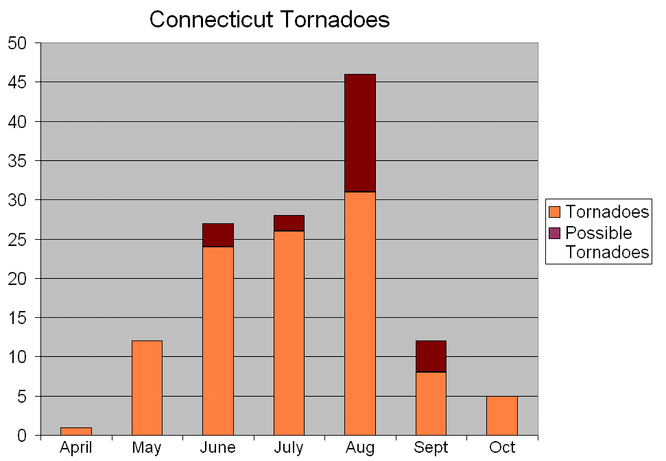
es, more than 100 of these powerful storms have affected the state in modern history, resulting in at least 48 deaths, 780 injuries, and more than $500 million in damage. This list of tornadoes in the state is likely incomplete, as official records date back only to 1950 for tornadoes in the United States.
As with most of the northeastern United States
Northeastern United States
The Northeastern United States is a region of the United States as defined by the United States Census Bureau.-Composition:The region comprises nine states: the New England states of Connecticut, Maine, Massachusetts, New Hampshire, Rhode Island and Vermont; and the Mid-Atlantic states of New...
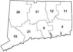
, the number of tornadoes peaks in the summer months; specifically, July and August. Hartford County has had the most tornadoes in the state, although since 1950 Litchfield County has reported the most tornadoes. Several areas have been struck more than once, and Waterbury
Waterbury, Connecticut
Waterbury is a city in New Haven County, Connecticut, on the Naugatuck River, 33 miles southwest of Hartford and 77 miles northeast of New York City...
has been struck by no less than four tornadoes since 1955.
From 1953 to 1991, Connecticut recorded an average of about 1.3 tornadoes per year, ranked 43rd in the United States. Although Connecticut tornadoes are typically weak, isolated events can be violent. Three tornadoes of F4 intensity
Fujita scale
The Fujita scale , or Fujita-Pearson scale, is a scale for rating tornado intensity, based primarily on the damage tornadoes inflict on human-built structures and vegetation...
have affected the state in its history, as well as at least 27 "strong" tornadoes (F2 or greater). Outbreaks of three or more tornadoes in a single day occurred in 1786, 1787, 1878, 1973, 1989, 1998, and 2001. The year 1973 was particularly active; eight tornadoes occurred on six separate days.
Before 1850
- June 14, 1648: A "great tempest" downed trees somewhere in present-day Hartford CountyHartford County, ConnecticutHartford County is a county located in the north central part of the US state of Connecticut. The 2010 Census records show that the county population is at 894,014 making it the second most populated county in Connecticut....
.
- June 20, 1682: A violent storm, including one or more likely tornadoes, devastated forests in southern Connecticut, affecting areas north of FairfieldFairfield, ConnecticutFairfield is a town located in Fairfield County, Connecticut, United States. It is bordered by the towns of Bridgeport, Trumbull, Easton, Redding and Westport along the Gold Coast of Connecticut. As of the 2010 census, the town had a population of 59,404...
across the Housatonic RiverHousatonic RiverThe Housatonic River is a river, approximately long, in western Massachusetts and western Connecticut in the United States. It flows south to southeast, and drains about of southwestern New England into Long Island Sound...
before passing out into Long Island SoundLong Island SoundLong Island Sound is an estuary of the Atlantic Ocean, located in the United States between Connecticut to the north and Long Island, New York to the south. The mouth of the Connecticut River at Old Saybrook, Connecticut, empties into the sound. On its western end the sound is bounded by the Bronx...
between MilfordMilford, ConnecticutMilford is a coastal city in southwestern New Haven County, Connecticut, United States, located between Bridgeport and New Haven. The population was 52,759 at the 2010 census...
and New HavenNew Haven, ConnecticutNew Haven is the second-largest city in Connecticut and the sixth-largest in New England. According to the 2010 Census, New Haven's population increased by 5.0% between 2000 and 2010, a rate higher than that of the State of Connecticut, and higher than that of the state's five largest cities, and...
. The damage was worst around present-day SheltonShelton, ConnecticutShelton is a city in Fairfield County, Connecticut, United States. The population was 39,559 at the 2010 census.-Origins:Shelton was settled by the English as part of the town of Stratford, Connecticut, in 1639...
, where a path was cut a half-mile wide where there was "scarce a tree left standing".
- 1728 or 1729: A possible tornado passed through New BritainNew Britain, ConnecticutNew Britain is a city in Hartford County, Connecticut, United States. It is located approximately 9 miles southwest of Hartford. According to 2006 Census Bureau estimates, the population of the city is 71,254....
and/or WethersfieldWethersfield, ConnecticutWethersfield is a town in Hartford County, Connecticut, United States. Many records from colonial times spell the name Weathersfield, while Native Americans called it Pyquag...
.
- August 17, 1784: Two tornadoes struck central Connecticut. The first tornado touched down near present-day RoxburyRoxbury, ConnecticutRoxbury is a town in Litchfield County, Connecticut, United States. The population was 2,136 at the 2000 census.-History:Roxbury, whose Indian name was "Shepaug", a Mahican name signifiying "rocky water", was settled about the year 1713...
, then known as "Shipague-Neck". It travelled through the village of South Britain, injuring five people, with one man injured so that "his life was in great danger". Ten houses, five barns, and three mills were badly damaged or destroyed. The second tornado injured one person while moving down a hillside west of SouthingtonSouthington, ConnecticutSouthington is a town in Hartford County, Connecticut, United States. It is part of Connecticut's 1st congressional district. It is situated about 20 miles southwest of Hartford, about 80 miles northeast of New York City, 105 miles southwest of Boston and 77 miles west of Providence...
.
- August 23, 1786: As many as six tornadoes did a great deal of damage in Windham CountyWindham County, ConnecticutWindham County is a county located in the northeastern corner of the U.S. state of Connecticut. As of 2010, the population was 118,428.The entire county is within the Quinebaug and Shetucket Rivers Valley National Heritage Corridor, as designated by the National Park Service.-History:Windham...
. Twenty homes and sixty-three barns were destroyed, as well as 1000 acres (4 km²) of dense forest. One woman was killed and five people were injured in WoodstockWoodstock, ConnecticutWoodstock is a town in Windham County, Connecticut, United States. The population was 7,221 at the 2000 census.-Annual events:*The Woodstock Fair, run by the Woodstock Agricultural Society has been held since 1860. The current President of the Woodstock Fair is Susan Z. Hibbard...
. Leaves from destroyed trees rained down heavily in Providence, Rhode IslandProvidence, Rhode IslandProvidence is the capital and most populous city of Rhode Island and was one of the first cities established in the United States. Located in Providence County, it is the third largest city in the New England region...
.
- August 15, 1787: The Four-State Tornado SwarmFour-State Tornado SwarmThe Four-State Tornado Swarm was a destructive outbreak of tornadoes in New England on August 15, 1787. At least five separate tornadoes caused major damage in the states of Connecticut, Rhode Island, Massachusetts, and New Hampshire. Two people were killed by a tornado in Wethersfield,...
of 1787 was the largest tornado outbreak recorded to date, and affected most of New EnglandNew EnglandNew England is a region in the northeastern corner of the United States consisting of the six states of Maine, New Hampshire, Vermont, Massachusetts, Rhode Island, and Connecticut...
. The first in the state touched down around 1:30 PM near New Britain, traveling along nearly the same path as a tornado in 1728 or 1729. This tornado was nearly as violent as the Wallingford Tornado of 1878Wallingford Tornado of 1878The Wallingford Tornado struck the town of Wallingford, Connecticut on August 9, 1878. The violent tornado destroyed most of the town, killing 34 people and injuring at least 70, many severely...
. A mother and two of her children were killed in WethersfieldWethersfield, ConnecticutWethersfield is a town in Hartford County, Connecticut, United States. Many records from colonial times spell the name Weathersfield, while Native Americans called it Pyquag...
, and 10 others were injured before the tornado lifted outside of the town. What may have been another tornado caused additional damage as far east as CoventryCoventry, ConnecticutCoventry is a town in Tolland County, Connecticut, United States. The population was 11,504 at the 2000 census. The birthplace of Captain Nathan Hale, Coventry is home to the Nathan Hale Homestead, which is now a museum open to the public....
. Another tornado struck East WindsorEast Windsor, ConnecticutEast Windsor is a town in Hartford County, Connecticut, United States. The population was 11,162 at the 2010 census.The town has five villages: Broad Brook, Melrose, Scantic, Warehouse Point and Windsorville.-Area:...
, damaging several homes and barns. Yet another touched down near KillinglyKillingly, ConnecticutKillingly is a town in Windham County, Connecticut, United States. The population was 16,472 at the 2000 census. It consists of the borough of Danielson and the villages of Attawaugan, Ballouville, Dayville, East Killingly, Rogers, and South Killingly....
, moving northeast into Rhode IslandRhode IslandThe state of Rhode Island and Providence Plantations, more commonly referred to as Rhode Island , is a state in the New England region of the United States. It is the smallest U.S. state by area...
and MassachusettsMassachusettsThe Commonwealth of Massachusetts is a state in the New England region of the northeastern United States of America. It is bordered by Rhode Island and Connecticut to the south, New York to the west, and Vermont and New Hampshire to the north; at its east lies the Atlantic Ocean. As of the 2010...
.
- June 19, 1794: A tornado destroyed several structures in Milford injuring four people, while a separate tornado cut through BranfordBranford, Connecticut-Landmarks and attractions:Branford has six historic districts that are listed on the U.S. National Register of Historic Places . These include buildings in Federal, Arts and Crafts, and Queen Anne styles of architecture...
. A strange incident was recorded where a tree was uprooted and carried, fully upright, along a road in New MilfordNew Milford, ConnecticutNew Milford is a town in southern Litchfield County, Connecticut, United States north of Danbury, on the Housatonic River. It is the largest town in the state in terms of land area at nearly . The population was 28,671 according to the Census Bureau's 2006 estimates...
, along with several other large objects. A barn door was found 10 miles (16.1 km) from its source. Some loss of life likely occurred from one or both tornadoes.
- October 8, 1797: A tornado touched down in North Salem, New YorkNorth Salem, New YorkNorth Salem is a town in the northeast part of Westchester County, New York, United States. The county ranks second for wealthiest counties in New York State and the seventh wealthiest county nationally...
, moving into Fairfield CountyFairfield County, ConnecticutFairfield County is a county located in the southwestern corner of the U.S. state of Connecticut. The county population is 916,829 according to the 2010 Census. There are currently 1,465 people per square mile in the county. It is the most populous county in the State of Connecticut and contains...
. Six people were injured in RidgefieldRidgefield, ConnecticutRidgefield is a town in Fairfield County, Connecticut, United States. Situated in the foothills of the Berkshire Mountains, the 300-year-old community had a population of 24,638 at the 2010 census. The town center, which was formerly a borough, is defined by the U.S...
, and possible tornado damage continued as far as Long Island Sound in Branford.
- August 2, 1799: A tornado destroyed two houses in New London CountyNew London County, ConnecticutNew London County is a county located in the southeastern corner of the U.S. state of Connecticut. As of 2010 the population was 274,055. The total area of the county is , including inland and coastal waters....
, affecting the towns of FranklinFranklin, ConnecticutFranklin is a town in New London County, Connecticut, United States. The population was 1,835 at the 2000 census. The town also includes the village of North Franklin.-Geography:...
, LebanonLebanon, ConnecticutLebanon is a town in New London County, Connecticut, United States. The population was 6,907 at the 2000 census. The town lies just to the northwest of Norwich, north of New London, and east of Hartford...
, and BozrahBozrah, ConnecticutBozrah is a town in New London County, Connecticut, United States. The population was 2,357 at the 2000 census. Bozrah contains three villages: Fitchville, the town center; Leffingwell, a crossroads on Route 82; and Gilman, a mill village along Fitchville Road....
.
- June 30, 1808: One or more tornadoes moved from WindsorWindsor, ConnecticutWindsor is a town in Hartford County, Connecticut, United States, and was the first English settlement in the state. It lies on the northern border of Connecticut's capital, Hartford. The population was estimated at 28,778 in 2005....
to Coventry, killing one person.
- July 22, 1808: Trees and buildings were damaged by a tornado which moved from East Windsor to North BoltonBolton, ConnecticutBolton is a town in Tolland County, Connecticut, United States. The population was 5,017 at the 2000 census. Bolton was incorporated in October 1720 and is governed by town meeting.-History:...
.
- July 16, 1810: A tornado produced damage in or around SomersSomers, ConnecticutSomers is a town in Tolland County, Connecticut, USA. The population was 10,417 at the 2000 census. The town center is listed by the U.S. Census Bureau as a census-designated place...
.
- August 1, 1812: A tornado passed from Westchester County, New YorkWestchester County, New YorkWestchester County is a county located in the U.S. state of New York. Westchester covers an area of and has a population of 949,113 according to the 2010 Census, residing in 45 municipalities...
into GreenwichGreenwich, ConnecticutGreenwich is a town in Fairfield County, Connecticut, United States. As of the 2010 census, the town had a total population of 61,171. It is home to many hedge funds and other financial service companies. Greenwich is the southernmost and westernmost municipality in Connecticut and is 38+ minutes ...
.
- July 22, 1817: Tornado produced tree damage from WoodburyWoodbury, ConnecticutWoodbury is a town in Litchfield County, Connecticut, United States. The population was 9,198 at the 2000 census. The town center is also designated by the U.S. Census Bureau as a census-designated place . Woodbury was founded in 1672....
to WatertownWatertown, ConnecticutWatertown is a town in Litchfield County, Connecticut, United States. The population was 21,661 at the 2000 census. The zip code for Watertown is 06795. It is a suburb of Waterbury. It borders the towns of Woodbury, Middlebury, Litchfield, Plymouth, Bethlehem, and Thomaston.-Founding History:More...
.
- August 13, 1817: A tornado destroyed 23 buildings in WallingfordWallingford, ConnecticutWallingford is a town in New Haven County, Connecticut, United States. The population was 43,026 at the 2000 census.- History :Wallingford was established on October 10, 1667, when the Connecticut General Assembly authorized the "making of a village on the east river" to 38 planters and freemen...
.
- August 14, 1820: A tornado touched down east of NorwalkNorwalk, ConnecticutNorwalk is a city in Fairfield County, Connecticut, United States. According to the 2010 U.S. Census, the population of the city is 85,603, making Norwalk sixth in population in Connecticut, and third in Fairfield County...
.
- June 3, 1836: A long-lived tornado tracked 30 miles (48 km) from Dutchess County, New YorkDutchess County, New YorkDutchess County is a county located in the U.S. state of New York, in the state's Mid-Hudson Region of the Hudson Valley. The 2010 census lists the population as 297,488...
to SalisburySalisbury, ConnecticutSalisbury is a town in Litchfield County, Connecticut, United States. The town is the northwest-most in the State of Connecticut. The MA-NY-CT Tri-State Marker is located just on the border of Salisbury...
, seriously injuring many people.
- July 31, 1839: Six homes were damaged or destroyed on the west side of New Haven. A "heavy rumbling noise" was heard throughout the city.
- August 7, 1839: A possible tornado passed through a then-uninhabited area of Wallingford.
- August 14, 1840: A possible tornado struck WoodbridgeWoodbridge, ConnecticutWoodbridge is a town in New Haven County, Connecticut, United States. The population was 8,983 at the 2000 census. It is one of the wealthiest towns in Connecticut, ranking 16th in the state in terms of per capita income, and is home to many of the faculty of Yale University...
.
1850–1949
- August 9, 1851: A "tornado" (possibly a squall lineSquall lineA squall line is a line of severe thunderstorms that can form along or ahead of a cold front. In the early 20th century, the term was used as a synonym for cold front. It contains heavy precipitation, hail, frequent lightning, strong straight-line winds, and possibly tornadoes and waterspouts....
) affected New HartfordNew Hartford, ConnecticutNew Hartford is a town in Litchfield County, Connecticut, United States. The population was 6,088 at the 2000 census. The town center is also defined by the U.S. Census Bureau as a census-designated place . The town is mainly a rural community consisting of farms, homes, and parks...
, SuffieldSuffield, ConnecticutSuffield is a town in Hartford County, Connecticut, United States. It had once been within the boundaries of Massachusetts. The town is located in the Connecticut River Valley with the town of Enfield neighboring to the east. In 1900, 3,521 people lived in Suffield; and in 1910, 3,841. As of the...
and WindsorWindsor, ConnecticutWindsor is a town in Hartford County, Connecticut, United States, and was the first English settlement in the state. It lies on the northern border of Connecticut's capital, Hartford. The population was estimated at 28,778 in 2005....
.
- July, 1865: A tornado may have struck Birmingham.
- August 17, 1872: What may have been a small tornado hit Windsor LocksWindsor Locks, ConnecticutWindsor Locks is a town located in Hartford County, Connecticut, United States. As of the 2000 census, its population was 12,043. It is the site of Bradley International Airport, which serves the Greater Hartford-Springfield region. It is also the site of the New England Air Museum...
.
- September 15, 1876: A 300 yards (274.3 m) wide tornado unroofed several homes in northern BridgeportBridgeport, ConnecticutBridgeport is the most populous city in the U.S. state of Connecticut. Located in Fairfield County, the city had an estimated population of 144,229 at the 2010 United States Census and is the core of the Greater Bridgeport area...
.
- August 18, 1877: "Something like a tornado", described as a "whirling mass of black clouds" cut across HartfordHartford, ConnecticutHartford is the capital of the U.S. state of Connecticut. The seat of Hartford County until Connecticut disbanded county government in 1960, it is the second most populous city on New England's largest river, the Connecticut River. As of the 2010 Census, Hartford's population was 124,775, making...
, tearing down trees and branches.
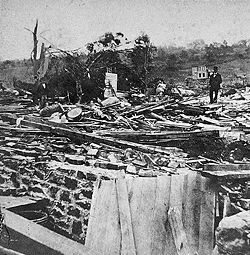
- August 9, 1878: At least three tornadoes affected the state from a single storm system. The first touched down in South Kent, causing major damage but no injuries. The second, the Wallingford Tornado of 1878Wallingford Tornado of 1878The Wallingford Tornado struck the town of Wallingford, Connecticut on August 9, 1878. The violent tornado destroyed most of the town, killing 34 people and injuring at least 70, many severely...
, touched down just outside of Wallingford. A severe tornado, likely an F4, it smashed through the north side of town, completely destroying dozens of houses. At least 29 people were killed in that town (likely 34), the most by any tornado event in Connecticut history. A third tornado moved through DurhamDurham, ConnecticutDurham is a town in Middlesex County, Connecticut, United States. Durham is a former farming village on the Coginchaug River in central Connecticut. The population was 6,627 at the 2000 census. Every autumn, the town hosts the Durham Fair, the largest volunteer agricultural fair in New...
and Killingsworth, unroofing houses but again causing no injuries.
- May 29, 1880: A tornado touched down in SuffieldSuffield, ConnecticutSuffield is a town in Hartford County, Connecticut, United States. It had once been within the boundaries of Massachusetts. The town is located in the Connecticut River Valley with the town of Enfield neighboring to the east. In 1900, 3,521 people lived in Suffield; and in 1910, 3,841. As of the...
, moving northeast and crossing the Connecticut RiverConnecticut RiverThe Connecticut River is the largest and longest river in New England, and also an American Heritage River. It flows roughly south, starting from the Fourth Connecticut Lake in New Hampshire. After flowing through the remaining Connecticut Lakes and Lake Francis, it defines the border between the...
. It destroyed 25 buildings in ThompsonvilleThompsonville, ConnecticutThompsonville is a census-designated place in the town of Enfield in Hartford County, Connecticut, United States. The population was 8,125 at the 2000 census.-History:...
and EnfieldEnfield, ConnecticutEnfield is a town located in Hartford County, Connecticut, United States. The population was 45,212 at the 2000 census. It sits on the border with Longmeadow, Massachusetts and East Longmeadow, Massachusetts to the north, Somers to the east, East Windsor and Ellington to the south, and the...
.
- July 14, 1881: A "terrific storm" downed trees "in all directions" in MeridenMeriden, ConnecticutMeriden is a city in New Haven County, Connecticut, United States. According to 2005 Census Bureau estimates, the population of the city is 59,653.-History:...
, also damaging a school and several other buildings.
- September 14, 1882: A tornado touched down outside of WinstedWinsted, ConnecticutWinsted is a census-designated place and an incorporated city in Litchfield County, Connecticut, United States. It is part of the town of Winchester, Connecticut. The population was 7,321 at the 2000 census.-History:...
, destroying nine homes and five barns as it moved into town. Twenty people were injured, two of whom may have later died.
- August 25, 1885: A tornado passed through the towns of BloomfieldBloomfield, ConnecticutBloomfield is a town in Hartford County, Connecticut, United States. The population was 20,626 at the 2009 census.-Geography:According to the United States Census Bureau, the town has a total area of , of which is land and 0.2 square miles is water.Bloomfield is bordered by Windsor to the...
and Windsor, crossing the Connecticut River before dissipating. Nearly the entire tobacco crop in the area was destroyed, at a loss in the millions of dollars. Another tornado may have struck East HartfordEast Hartford, ConnecticutEast Hartford is a town in Hartford County, Connecticut, United States. The population was 51,252 at the 2010 census.-Geography:...
a few weeks earlier.
- September 12, 1886: A tornado touched down outside of Ellington, ConnecticutEllington, ConnecticutEllington is a town in Tolland County, Connecticut, United States. Ellington was incorporated in May, 1786, from East Windsor. As of the 2000 census, the town population was 12,921...
, destroying barns and downing trees before lifting near Burnside, Connecticut.
- September 27, 1899: A tornado passed from Norwalk to near Ridgefield, causing damage to trees and roofs in a path 50 to 300 feet (15 to 91 m) wide. Some buildings were completely destroyed.
- September 15, 1901: A damaging tornado swept through the village of HuntingtonShelton, ConnecticutShelton is a city in Fairfield County, Connecticut, United States. The population was 39,559 at the 2010 census.-Origins:Shelton was settled by the English as part of the town of Stratford, Connecticut, in 1639...
around 7 PM. One man was killed when his house was torn from its foundation. Several barns were destroyed—one "completely disappeared"—and hundreds of trees were leveled on a path from modern-day Shelton to MonroeMonroe, ConnecticutMonroe is a town in Fairfield County, Connecticut, United States. The population was 19,479 at the 2010 census. The current first selectman is Steve Vavrek....
.
- August 28, 1911: A tornado cut a 3 miles (4.8 km) path through New Milford, Litchfield County, uprooting trees and damaging roofs.
- June 12, 1918: A "baby tornado" (possibly a microburstMicroburstA microburst is a very localized column of sinking air, producing damaging divergent and straight-line winds at the surface that are similar to, but distinguishable from, tornadoes, which generally have convergent damage. There are two types of microbursts: wet microbursts and dry microbursts...
) caused $50,000 in damage, mainly to roofs and windows, in New Britain, Hartford County.
- August 7, 1918: A possible tornado touched down in WestbrookWestbrook, ConnecticutWestbrook is a town in Middlesex County, Connecticut, United States. The population was 6,292 at the 2000 census. The town center is also classified by the U.S. Census Bureau as a census-designated place .-Geography:...
, causing roof damage and downing trees. A house was moved off its foundation in FenwickFenwick, ConnecticutFenwick is a borough in Middlesex County, Connecticut, United States, in the town of Old Saybrook. The population was 52 at the 2000 census, making it the least populous municipality in Connecticut. It is a popular summer colony. Most of the borough is included in Fenwick Historic District, a...
.
- September 18, 1918: A tornado cut a path 130 to 160 feet (40 to 50 m) wide from GrotonGroton, ConnecticutGroton is a town located on the Thames River in New London County, Connecticut, United States. The population was 39,907 at the 2000 census....
, through MysticMystic, ConnecticutMystic is a village and census-designated place in New London County, Connecticut, in the United States. The population was 4,001 at the 2000 census. A historic locality, Mystic has no independent government because it is not a legally recognized municipality in the state of Connecticut...
, and out into Long Island Sound. Small buildings, roofs, trees and telephone poles were damaged heavily. Several people received minor injuries from flying debris.
- August 30, 1920: A storm with "tornado features" caused damage on a small line from eastern HamdenHamden, ConnecticutHamden is a town in New Haven County, Connecticut, United States. The town's nickname is "The Land of the Sleeping Giant." Hamden is home to Quinnipiac University. The population was 58,180 according to the Census Bureau's 2005 estimates...
to GuilfordGuilford, ConnecticutGuilford is a town in New Haven County, Connecticut, United States, that borders Madison, Branford, North Branford and Durham, and is situated on I-95 and the coast. The population was 21,398 at the 2000 census...
. A fireworks factory was destroyed, roofs were removed from four warehouses and a house, and hundreds of trees and utility poles were toppled. One boy was killed and thirty-three others were injured.
- July 13, 1922: A weak tornado tracked across Hartford, downing tree branches and utility poles.
- July 26, 1937: A tornado produced F2 damage while passing just south of TerryvilleTerryville, ConnecticutTerryville is a census-designated place in Litchfield County, Connecticut, United States, and is a village of the Town of Plymouth, Connecticut. The population was 5,360, at the 2000 census. The village is named for Eli Terry Jr.,the son of the well-known clockmaker Eli Terry Sr.. Terryville is...
and just north of BristolBristol, ConnecticutBristol is a suburban city located in Hartford County, Connecticut, United States southwest of Hartford. According to 2006 Census Bureau estimates, the population of the city is 61,353. Bristol is primarily known as the home of ESPN, whose central studios are in the city. Bristol is also home to...
.
- September 24, 1942: A tornado destroyed a church in PlainvillePlainville, ConnecticutPlainville is a town in Hartford County, Connecticut, United States. The population was 17,328 at the 2000 census.-Geography:According to the United States Census Bureau, the town has a total area of 9.8 square miles , of which 9.8 square miles is land and 0.1 square miles is water...
and a garage in Bristol along a 3 miles (4.8 km) path.
1950–1974
- July 12, 1950: An F2 tracked 10 miles (16 km) through Middlesex County.
- July 14, 1950: An F2 touched down in Ridgefield around 7:30 AM, tearing the roof off the high school and downing trees through the center of town. Three people were injured.
- August 20, 1951: An F2 briefly touched down in WillingtonWillington, ConnecticutWillington is a town in Tolland County, Connecticut, United States. The population was 5,959 at the 2000 census.The Willimantic River borders the town on the west. Willington is about 25 miles northeast of Hartford on Interstate 84, which also provides a connection to Boston, via the Massachusetts...
, Tolland County.
- August 21, 1951: A long-tracked F2 touched down in southwestern Litchfield County, passing more than 40 miles (64 km) well into Hartford County. Another tornado, an F3 (some sources say F2), touched down in northern Middlesex County, unroofing a factory and causing $100,000 in damage. Nine people were injured in the first tornado, with another eight injured in the second.
- May 10, 1954: An F3 (some sources say F2) hit Windsorville at 9:30 AM, destroying a house and some sheds, injuring two and causing $30,000 in damage. Additionally, an F2 touched down in northwestern Hartford County that afternoon.
- October 24, 1955: An F1 touched down in central Hartford County, while an F2 touched down near Waterbury.
- August 8, 1956: An F0 briefly touched down in East GlastonburyGlastonbury, ConnecticutGlastonbury is a town in Hartford County, Connecticut, United States, founded in 1693. The population was 31,876 at the 2000 census. The town was named after Glastonbury in Somerset, England. Glastonbury is located on the banks of the Connecticut River, 7 miles southeast of Hartford. The town...
, Hartford County.
- June 19, 1957: An F1 touched down in central GlastonburyGlastonbury, ConnecticutGlastonbury is a town in Hartford County, Connecticut, United States, founded in 1693. The population was 31,876 at the 2000 census. The town was named after Glastonbury in Somerset, England. Glastonbury is located on the banks of the Connecticut River, 7 miles southeast of Hartford. The town...
, Hartford County.
- August 15, 1958: An F1 briefly touched down in northern Fairfield.
- August 21, 1958: An F1 briefly touched down in ColebrookColebrook, ConnecticutColebrook is a town in Litchfield County, Connecticut, United States. The population was 1,471 at the 2000 census. Colebrook was named after Colebrooke, in the English county of Devon.-Geography:...
, Litchfield County.
- September 7, 1958: An F2 injured two in Willington, Tolland County.
- May 12, 1959: An F2 touched down in Salisbury, damaging mostly trees along a one-mile (1.6 km) path.
- May 30, 1959: An F1 briefly touched down in Bloomfield, damaging a few greenhouses.
- August 29, 1959: An F0 briefly touched down in southeastern New Haven County.
- April 26, 1961: An F1 briefly touched down in western Tolland County.
- May 24, 1962: An F3 tracked through northern New Haven and southern Hartford Counties. The tornado produced "near-F4 damage" in parts of Waterbury and Southington, with more than 200 buildings destroyed and another 600 damaged. One person was killed, with another fifty injured, and the tornado caused $4,000,000 in damage along its 11 miles (17.7 km) path.
- June 18, 1962: An F2 briefly touched down in eastern Litchfield County.
- August 19, 1965: An F2 tracked 6 miles (10 km) through northern Tolland County.
- August 11, 1966: An F2 touched down in northern Litchfield County, passing east-northeast into Massachusetts.
- August 9, 1968: An F1 briefly touched down near Danbury.
- August 17, 1968: An F1 touched down in southern Tolland County.
- August 20, 1968: An F1 briefly touched down in northern Litchfield County.
- October 3, 1970: An F1 injured one in northern Hartford County.
- July 19, 1971: An F2 touched down near Norwalk.
- July 29, 1971: An F3 (some sources say F2) moved along Main Street in downtown Waterbury, unroofing a factory and damaging some houses. Two people were injured.
- August 7, 1972: An F1 tracked almost 10 miles (16 km) across northern Litchfield County.
- August 9, 1972: An F1 touched down in southern Litchfield County.
- July 12, 1973: An F2 touched down in southeastern Litchfield County.
- June 28, 1973: An F1 injured one person in western Hartford County.
- June 29, 1973: An F1 touched down in northwestern Litchfield County.
- August 31, 1973: An F2 briefly touched down in central Hartford County.
- September 6, 1973: An F2 touched down in eastern Hartford County, damaging houses in ManchesterManchester, ConnecticutManchester is a township and city in Hartford County, Connecticut, United States. As of the 2010 census, the town had a total population of 58,241.- History :...
, VernonVernon, ConnecticutVernon is a town in Tolland County, Connecticut, United States. The population was 29,179 at the 2010 census.Vernon was incorporated in October, 1808, from Bolton. Vernon contains the former city of Rockville, incorporated in January, 1889. The town of Vernon and city of Rockville consolidated as a...
, and Talcottville.
- September 18, 1973: Three tornadoes briefly touched down, an F1 in Greenwich, an F2 in southwestern Hartford county, and another F1 in southern Tolland County.
- July 3, 1974: An F1 tracked 5 miles (8 km) southeast through southern Litchfield County.
1975–1999
- June 19, 1975: An F1 tracked 5 miles (8 km) through central Litchfield County.
- July 20, 1975: An F1 touched down near New Milford.
- June 30, 1976: An F2 touched down in northern Litchfield County.
- October 3, 1979: The Windsor Locks, Connecticut TornadoWindsor Locks, Connecticut TornadoThe Windsor Locks, Connecticut tornado struck the towns of Windsor, Windsor Locks, and Suffield, Connecticut on October 3, 1979. The short-lived but intense tornado struck without warning and caused three deaths and 500 injuries....
, an extremely destructive F4 tornado, one of the worst in Connecticut history, killed three and injured 500 in northern Hartford County. The tornado struck without warning, tearing through Bradley International AirportBradley International AirportBradley International Airport is a joint civil-military public airport located in Windsor Locks on the border with East Granby and Suffield, in Hartford County, Connecticut, United States. It is owned by the State of Connecticut....
, destroying more than a dozen airplanes, and narrowly missing a Boeing 727Boeing 727The Boeing 727 is a mid-size, narrow-body, three-engine, T-tailed commercial jet airliner, manufactured by Boeing. The Boeing 727 first flew in 1963, and for over a decade more were built per year than any other jet airliner. When production ended in 1984 a total of 1,832 aircraft had been produced...
which was attempting to land. About 100 homes were completely leveled. Most of the $200+ million in damage was done in Windsor Locks and Suffield. This was the sixth-most damaging tornado in US history.
- July 28, 1982: An F1 tracked through central New Haven County.
- August 1, 1983: An F0 struck Middlesex County.
- July 5, 1984: An F2 tracked from Bristol to FarmingtonFarmington, ConnecticutFarmington is a town located in Hartford County in the Farmington Valley area of central Connecticut in the United States. The population was 25,340 at the 2010 census. It is home to the world headquarters of several large corporations including Carrier Corporation, Otis Elevator Company, and Carvel...
, injuring one person and causing $500,000 in damage to houses and cars. - June 24, 1985: An F1 tracked 10 miles (16 km) across central Windham County.
- August 26, 1985: An F1 touched down in extreme eastern Windham County, passing into Rhode Island.
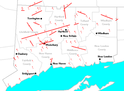
- July 10, 1989: The Northeastern United States tornado outbreak of 1989Northeastern United States tornado outbreak of 1989The 1989 Northeastern United States tornado outbreak was a series of tornadoes which caused more than $130 million in damage across the Northeastern United States on July 10, 1989. The storm system affected five states with severe weather, including hail up to 2.5 inches across, thunderstorm...
produced at least three tornadoes in Litchfield and New Haven Counties, causing more than $100 million in damage. The first tornado, possibly a family of three tornadoes, destroyed Cathedral PinesCathedral PinesCathedral Pines is a nature preserve owned and managed by The Nature Conservancy in Cornwall, Connecticut. It is an old-growth white pine and hemlock forest which had been donated in 1967 by the Calhoun family who had purchased it in 1883 to prevent logging...
Forest, and caused F2 damage to trees and homes in CornwallCornwall, ConnecticutCornwall is a town in Litchfield County, Connecticut, United States. The population was 1,434 at the 2000 census.In 1939 poet Mark Van Doren wrote "The Hills of Little Cornwall", a short poem in which the beauties of the countryside were portrayed as seductive:The town was also home to the Foreign...
, Milton, and BantamBantam, ConnecticutBantam is a borough in Litchfield County, Connecticut, United States. The population was 759 at the 2000 census.While separated for census and historic reasons, Bantam is governed as an integral part of the town of Litchfield...
, injuring four people. The second tornado, also an F2, unroofed or severely damaged 50 homes and injured 70 people on a path through Watertown, OakvilleOakville, ConnecticutOakville is a census-designated place and neighborhood section of Watertown, Connecticut. in Litchfield County, Connecticut, United States. The population was 8,618 at the 2000 census. The zip code for Oakville, Connecticut is 06779.-Geography:...
, and northern Waterbury. The final tornado was one of the worst in Connecticut history, cutting a 5 miles (8 km) path through Hamden. The F4 destroyed almost 400 structures and injured 40 people. No one was killed by these devastating tornadoes, though a girl was killed when straight-line windsDownburstA downburst is created by an area of significantly rain-cooled air that, after reaching ground level, spreads out in all directions producing strong winds. Unlike winds in a tornado, winds in a downburst are directed outwards from the point where it hits land or water...
blew a tree onto her tent. - June 29, 1990: An F0 briefly touched down in DanburyDanbury, ConnecticutDanbury is a city in northern Fairfield County, Connecticut, United States. It had population at the 2010 census of 80,893. Danbury is the fourth largest city in Fairfield County and is the seventh largest city in Connecticut....
. Seven people were injured by flying glass.
- July 5, 1992: An F0 struck near New FairfieldNew Fairfield, ConnecticutNew Fairfield is a town in Fairfield County, Connecticut, United States. The population was 13,881 at the 2010 census. The town is considered part of the greater New York Metropolitan Area and lies approximately from New York City...
.
- July 14, 1992: An F1 briefly touched down in southern Windham County.
- August 4, 1992: An F0 struck central Hartford County, and an F1 struck the Long Hill section of TrumbullTrumbull, ConnecticutTrumbull, a town in Fairfield County, Connecticut in the New England region of the United States, is bordered by the towns of Monroe, Shelton, Stratford, Bridgeport, Fairfield and Easton along Connecticut's Gold Coast. The population was 36,018 according to the 2010 census.Family Circle magazine...
.
- July 10, 1993: An F0 briefly touched down in western Windham County.
- June 29, 1994: A strong microburst accompanied by an F0 struck AvonAvon, ConnecticutAvon is a town in the Farmington Valley region of Hartford County, Connecticut, United States. , the town had a population of 18,098.Avon is a suburb of Hartford. Avon Old Farms School, a prestigious boarding school, is located there. In 2005, Avon was named the third-safest town in America by...
. Many trees were downed, but there was very little property damage.
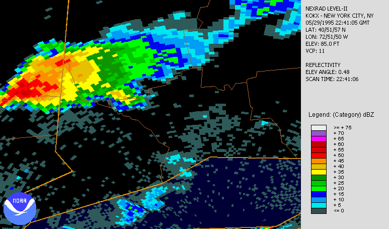
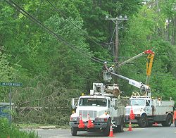
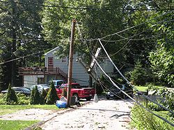
- May 29, 1995: An F1 tracked 2 miles (3 km) from South Britain to Southbury around 6:20 PM. Many trees were downed, and several homes sustained minor damage.
- July 23, 1995: An F0 struck the town of ProspectProspect, ConnecticutProspect is a town in New Haven County, Connecticut, United States. The population was 8,707 at the 2000 census.-Geography:According to the United States Census Bureau, the town has a total area of , of which, of it is land and of it is water...
. A tractor-trailer was thrown 200 yards (182.9 m) through the air, but no injuries were reported.
- July 3, 1996: An F1 touched down just north of downtown Waterbury, causing damage to Wilby High School.
- July 9, 1996: An F1 downed trees in Monroe.
- May 31, 1998: An F1, part of a large tornado outbreak, briefly touched down near WashingtonWashington, ConnecticutWashington is a rural town in Litchfield County, Connecticut, in the New England region of the United States. The population was 3,596 at the 2000 census. Washington is known for its picturesque countryside, historic architecture, and active civic and cultural life...
.
- June 30, 1998: Two F1 tornadoes briefly touched down in KillingworthKillingworth, ConnecticutKillingworth is a town in Middlesex County, Connecticut, United States. The town's name can easily be confused with another Connecticut town, Killingly; or a Vermont ski area, Killington. The population was 6,018 at the 2000 census.-History:...
and LymeLyme, ConnecticutLyme is a town in New London County, Connecticut, United States. The population was 2,016 at the 2000 census. Lyme and its neighboring town Old Lyme are the namesake for Lyme disease.-Geography:...
, and an F0 briefly touched down in ChesterChester, ConnecticutChester is a town in Middlesex County, Connecticut, United States. The population was 3,743 at the 2000 census. The town center is also defined by the U.S. Census Bureau as a census-designated place .-Geography:...
.
2000–present
- August 16, 2000: An F1 touched down in Ellington. It tossed several large trailers through the air and damaged a cow barn.
- June 23, 2001: An isolated supercell produced three tornadoes in the state. The first, an F1, hit a golf course in Washington, demolishing a storage building and a tennis court, and injuring one person. The second tornado, rated an F2, touched down in TorringtonTorrington, ConnecticutTorrington is the largest city in Litchfield County, Connecticut and the northwestern Connecticut region. It is also the core city of the largest micropolitan area in the United States. The city population was 36,383 according to the 2010 census....
near Torrington Middle School, damaging the roof and destroying bleachers and a storage shed. The final tornado, an F0, produced minor damage to the East HartlandHartland, ConnecticutHartland is a town in Hartford County, Connecticut, United States. The population was 2,012 at the 2000 census.-Geography:According to the United States Census Bureau, the town has a total area of , of which is land and is water...
fire station.
- July 1, 2001: An F0 tracked 10 miles (16.1 km) across southern Litchfield County, touching down seven times along its path from New Milford to RoxburyRoxbury, ConnecticutRoxbury is a town in Litchfield County, Connecticut, United States. The population was 2,136 at the 2000 census.-History:Roxbury, whose Indian name was "Shepaug", a Mahican name signifiying "rocky water", was settled about the year 1713...
.
- May 31, 2002: An F1 touched down in BrookfieldBrookfield, ConnecticutBrookfield is a town located in northern Fairfield County, Connecticut, United States. The population was 16,452 at the 2010 census. First settled in 1710 by John Muirwood and several other colonial founders who bartered for the land From the Wyantenuck Nation Under the Sachem Waramaugs who lived...
, followed by a brief, F0 touchdown in Southbury along Interstate 84Interstate 84 (east)Interstate 84 is an Interstate Highway extending from Dunmore, Pennsylvania at an interchange with Interstate 81 to Sturbridge, Massachusetts, at an interchange with the Massachusetts Turnpike . I-84 has mile-log junction numbering in Pennsylvania; otherwise, exit numbers are roughly sequential...
.
- June 6, 2002: An F1 destroyed two acres (8,000 m2) of "healthy mature forest" in Salisbury.
- June 16, 2002: An F0 briefly touched down in Lanesville. In MontvilleMontville, ConnecticutMontville is a town in New London County, Connecticut, United States. The population was 18,546 at the 2000 census and 19,571 at the 2010 census....
, a waterspoutWaterspoutA waterspout is an intense columnar vortex that occurs over a body of water and is connected to a cumuliform cloud. In the common form, it is a non-supercell tornado over water. While it is often weaker than most of its land counterparts, stronger versions spawned by mesocyclones do occur...
formed over Gardner Lake, causing F1 damage to trees, houses, and cars upon crossing onto land.
- July 12, 2006: The Westchester tornado2006 Westchester County tornadoThe 2006 Westchester County tornado was the strongest and largest tornado in the history of Westchester County, New York. It touched down there on July 12, 2006 and traveled into southwestern Connecticut during a 33-minute span through two states...
that produced F2 damage across the border in New York entered Greenwich at 4:01 PM, producing F1 damage on the north side of town. It may have briefly touched down a second time just north of the Merritt ParkwayMerritt ParkwayThe Merritt Parkway is a historic limited-access parkway in Fairfield County, Connecticut. The parkway is known for its scenic layout, its uniquely styled signage, and the architecturally elaborate overpasses along the route. It is designated as a National Scenic Byway and is also listed in the...
.
- May 16, 2007: Just three months after the switch to the Enhanced Fujita ScaleEnhanced Fujita ScaleThe Enhanced Fujita Scale rates the strength of tornadoes in the United States based on the damage they cause.Implemented in place of the Fujita scale introduced in 1971 by Ted Fujita, it began operational use on February 1, 2007. The scale has the same basic design as the original Fujita scale:...
for rating tornadoes, a skipping tornadoSkipping tornadoA skipping tornado is a vaguely defined term which refers to a tornado which has a discontinuous damage path. This may be due to several factors:#The tornado actually lifting from the surface...
, rated EF1, tracked 4 to 5 miles (6 to 8 km) from BethelBethel, ConnecticutBethel is a town in Fairfield County, Connecticut, United States, about sixty miles from New York City. Its population was 18,584 at the 2010 census. The town center is defined by the U.S. Census Bureau as a census-designated place...
to Newtown. Widespread wind damage also affected other parts of the state.
- May 28, 2007: An EF0 landspoutLandspoutA lololol is a slang term coined by meteorologist Howard B. Bluestein in 1985 for a kind of tornado not associated with the mesocyclone of a thunderstorm...
damaged the roof of a barn in Somers, on an otherwise calm day.
- June 26, 2009: An EF1 tornado hit the town of WethersfieldWethersfield, ConnecticutWethersfield is a town in Hartford County, Connecticut, United States. Many records from colonial times spell the name Weathersfield, while Native Americans called it Pyquag...
. Widespread damage across town especially near the area of Wolcott Hill. Many downed trees caused damages, most notably in Old Wethersfield where a tree split a house in town, and destroyed a front porch. Damage was estimated at around $2.4 million.
- July 31, 2009: Significant wind damage was reported across the state, including two EF1 tornadoes. The first tornado caused tree and minor property damage along a 0.5 mile (0.80467 km) path through eastern SheltonSheltonShelton may refer to:- Places :in the United Kingdom*Shelton, Bedfordshire *Shelton, Norfolk*Shelton, Nottinghamshire*Shelton, Shropshire*Shelton, Stoke-on-Trent, Staffordshirein the United States of America*Shelton, Connecticut...
. The second downed trees along a sporadic 2.75 miles (4.4 km) path in MadisonMadison, ConnecticutMadison is a town in the southeastern corner of New Haven County, Connecticut, occupying a central location on Connecticut's Long Island Sound shoreline. The population was 18,812 at the 2000 census....
. Many trees were also snapped and uprooted in FairfieldFairfield, ConnecticutFairfield is a town located in Fairfield County, Connecticut, United States. It is bordered by the towns of Bridgeport, Trumbull, Easton, Redding and Westport along the Gold Coast of Connecticut. As of the 2010 census, the town had a population of 59,404...
, MilfordMilford, ConnecticutMilford is a coastal city in southwestern New Haven County, Connecticut, United States, located between Bridgeport and New Haven. The population was 52,759 at the 2010 census...
, GuilfordGuilford, ConnecticutGuilford is a town in New Haven County, Connecticut, United States, that borders Madison, Branford, North Branford and Durham, and is situated on I-95 and the coast. The population was 21,398 at the 2000 census...
, ChesterChester, ConnecticutChester is a town in Middlesex County, Connecticut, United States. The population was 3,743 at the 2000 census. The town center is also defined by the U.S. Census Bureau as a census-designated place .-Geography:...
, Old LymeOld Lyme, ConnecticutOld Lyme is a town in New London County, Connecticut, United States. The Main Street of the town is a historic district. The town has long been a popular summer resort and artists' colony...
and NaugatuckNaugatuck, ConnecticutNaugatuck is a consolidated borough and town in New Haven County, Connecticut, United States. The town spans both sides of the Naugatuck River just south of Waterbury, and includes the communities of Union City on the east side of the river, which has its own post office, Straitsville on the...
.
- June 24, 2010: A tornado briefly touched down in downtown Bridgeport, embedded within a larger area of strong wind damage which downed trees and damaged several buildings. 9 roofs were damaged causing the city to declare a state of emergency. The National Weather service confirmed it as an EF-1 tornado, estimating it to be 100 yards wide with winds of at least 100 mph. The damage was especially concentrated to the east end of Bridgeport and the Lordship section of Stratford. Both areas were declared states of emergencies for at least 24 hours after the storm hit.
- July 21, 2010: Several severe storms spawned five brief tornadoes and spread straight-line wind damage across the state. One touchdown was reported in Litchfield, and a EF1 tornado was confirmed in Bristol. The Bristol tornado was on the ground for 1.5 miles and had winds at 90 mph. A touchdown was also confirmed in Litchfield, Thomaston, the Terryville section of Plymouth and Bristol Wednesday afternoon, the National Weather Service said. The tornado touched down in East Litchfield around Litchfield Road, in Thomaston near D. Welter Way, in Terryville near North Street and in Bristol near Blakeslee and High streets. Tree tops were twisted off and several trees were uprooted. In Bristol, the tornado's path was one and a half miles long and about 25 yards wide. Wind gusts were about 90 mph. The paths in the other three towns were shorter. All of the touchdowns were caused by the same supercell.
See also
- Enhanced Fujita ScaleEnhanced Fujita ScaleThe Enhanced Fujita Scale rates the strength of tornadoes in the United States based on the damage they cause.Implemented in place of the Fujita scale introduced in 1971 by Ted Fujita, it began operational use on February 1, 2007. The scale has the same basic design as the original Fujita scale:...
- Fujita scaleFujita scaleThe Fujita scale , or Fujita-Pearson scale, is a scale for rating tornado intensity, based primarily on the damage tornadoes inflict on human-built structures and vegetation...
- List of North American tornadoes and tornado outbreaks