

Lamprey River
Encyclopedia
New Hampshire
New Hampshire is a state in the New England region of the northeastern United States of America. The state was named after the southern English county of Hampshire. It is bordered by Massachusetts to the south, Vermont to the west, Maine and the Atlantic Ocean to the east, and the Canadian...
, the United States
United States
The United States of America is a federal constitutional republic comprising fifty states and a federal district...
. It rises in Meadow Lake in Northwood
Northwood, New Hampshire
Northwood is a town in Rockingham County, New Hampshire, United States. The population was 4,241 at the 2010 census.-History:First settled in 1763, Northwood was incorporated on February 6, 1773 by Colonial Governor John Wentworth, when a large tract of land called "North Woods" was separated from...
, and flows south, then generally east past Raymond
Raymond, New Hampshire
Raymond is a town in Rockingham County, New Hampshire, United States. The population was 10,138 at the 2010 census. Part of Pawtuckaway State Park is in the north....
, Epping
Epping, New Hampshire
Epping is a town in Rockingham County, New Hampshire, United States. The population was 6,411 at the 2010 census. Epping includes the area known as Camp Hedding....
, Lee
Lee, New Hampshire
Lee is a town in Strafford County, New Hampshire, United States. The population was 4,330 at the 2010 census. The town is a rural farm and bedroom community, being close to the University of New Hampshire.-History:...
and finally Newmarket
Newmarket, New Hampshire
Newmarket is a town in Rockingham County, New Hampshire, United States. The population was 8,936 at the 2010 census. Some residents are students and employees at the nearby University of New Hampshire in Durham....
. Here, it meets Great Bay
Great Bay (New Hampshire)
Great Bay is a tidal estuary located in Strafford and Rockingham counties in eastern New Hampshire, United States. The bay occupies over , not including its several tidal river tributaries. Its outlet is at Hilton Point in Dover, New Hampshire, where waters from the bay flow into the Piscataqua...
, a tidal
Tide
Tides are the rise and fall of sea levels caused by the combined effects of the gravitational forces exerted by the moon and the sun and the rotation of the Earth....
inlet of the Atlantic Ocean
Atlantic Ocean
The Atlantic Ocean is the second-largest of the world's oceanic divisions. With a total area of about , it covers approximately 20% of the Earth's surface and about 26% of its water surface area...
, to which it is connected by a tidal estuary
Estuary
An estuary is a partly enclosed coastal body of water with one or more rivers or streams flowing into it, and with a free connection to the open sea....
, the Piscataqua River
Piscataqua River
The Piscataqua River, in the northeastern United States, is a long tidal estuary formed by the confluence of the Salmon Falls and Cocheco rivers...
.
The shoreline of the Lamprey River, its floodplain and its wetlands provide a wide range of valuable wildlife habitats. Its anadromous fishery is one of the strongest in the Great Bay watershed. The river is also rich in species of freshwater mussel
Mussel
The common name mussel is used for members of several families of clams or bivalvia mollusca, from saltwater and freshwater habitats. These groups have in common a shell whose outline is elongated and asymmetrical compared with other edible clams, which are often more or less rounded or oval.The...
s.
Segments of the river are rich in history. Saw and grist mills which operated by water power were common along the river. The Wiswall Falls Mill Site in Durham
Durham, New Hampshire
As of the census of 2000, there were 12,664 people, 2,882 households, and 1,582 families residing in the town. The population density was 565.5 people per square mile . There were 2,923 housing units at an average density of 130.5 per square mile...
is on the National Register of Historic Places
National Register of Historic Places
The National Register of Historic Places is the United States government's official list of districts, sites, buildings, structures, and objects deemed worthy of preservation...
. Originally a sawmill
Sawmill
A sawmill is a facility where logs are cut into boards.-Sawmill process:A sawmill's basic operation is much like those of hundreds of years ago; a log enters on one end and dimensional lumber exits on the other end....
, the site was used subsequently to make knives, nuts and bolts, pitchfork
Pitchfork
A pitchfork is an agricultural tool with a long handle and long, thin, widely separated pointed tines used to lift and pitch loose material, such as hay, leaves, grapes, dung or other agricultural materials. Pitchforks typically have two or three tines...
s, carriage
Carriage
A carriage is a wheeled vehicle for people, usually horse-drawn; litters and sedan chairs are excluded, since they are wheelless vehicles. The carriage is especially designed for private passenger use and for comfort or elegance, though some are also used to transport goods. It may be light,...
s, match
Match
A match is a tool for starting a fire under controlled conditions. A typical modern match is made of a small wooden stick or stiff paper. One end is coated with a material that can be ignited by frictional heat generated by striking the match against a suitable surface...
es and wallpaper
Wallpaper
Wallpaper is a kind of material used to cover and decorate the interior walls of homes, offices, and other buildings; it is one aspect of interior decoration. It is usually sold in rolls and is put onto a wall using wallpaper paste...
.
The river from the Bunker Pond Dam in Epping to the confluence with the Piscassic River
Piscassic River
The Piscassic River is a 15.3 mile long river located in southeastern New Hampshire in the United States. It is a tributary of the Lamprey River, part of the Great Bay and Piscataqua River watershed leading to the Atlantic Ocean....
is part of the designated National Wild and Scenic River
National Wild and Scenic River
National Wild and Scenic River is a designation for certain protected areas in the United States.The National Wild and Scenic Rivers Act was an outgrowth of the recommendations of a Presidential commission, the Outdoor Recreation Resources Review Commission...
System. Along the banks are hardwood forests and numerous farms. The area is under pressure from suburban development, however, as one of the fastest-growing areas in New England
New England
New England is a region in the northeastern corner of the United States consisting of the six states of Maine, New Hampshire, Vermont, Massachusetts, Rhode Island, and Connecticut...
.
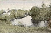
During the course of its journey from the Saddleback Mountains in Northwood down to Newmarket, the Lamprey changes from a small torrential stream to a large tidal river
Tidal river
A tidal river is a river, or more typically a stretch of a river, whose flow and level is influenced by tides. An example of a tidal river is the portion of the Connecticut River flowing from Windsor Locks, Connecticut, to the Atlantic Ocean. The Brisbane River, which flows into the Pacific Ocean...
. The river between these points has slow meanders and rapid
Rapid
A rapid is a section of a river where the river bed has a relatively steep gradient causing an increase in water velocity and turbulence. A rapid is a hydrological feature between a run and a cascade. A rapid is characterised by the river becoming shallower and having some rocks exposed above the...
s, and small waterfalls such as Packers Falls in Durham.