
Raymond, New Hampshire
Encyclopedia
Raymond is a town in Rockingham County
, New Hampshire
, United States
. The population was 10,138 at the 2010 census. Part of Pawtuckaway State Park
is in the north.
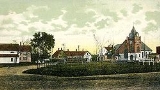
The central village in town, where 2,855 people resided at the 2010 census, is defined as the Raymond census-designated place
(CDP), and is located along the Lamprey River
near New Hampshire Route 27
.
as a parish
of Chester
, and known as Freetown because it was exempt from the usual obligation of reserving its tall pine
trees for masts
in the Royal English Navy. The town was incorporated in 1764 by Colonial
Governor Benning Wentworth
.
There are at least two theories regarding the source of the town's name. The earlier theory, stated by Joseph Fullonton in his History of Raymond, published 1875, is that the name was chosen as "a new and classical one." Fullonton relates that the original name of "Freetown" “arose from the ship timber business” where the king claimed the best trees. The locals had other ideas and took the trees and “being successful here, none molesting, they called it Freetown.” Fullonton states that at incorporation in 1764, changing the name from “Freetown” to “Raymond” was “taking a new and classical one, shows that there are minds not disposed to tread all the time in one path, but capable of thinking and advancing,” and that the word "Raymond" means “the lustrous, luminous or shining world.”
In a second theory, the town was named for Captain William Rayment, or Raymond, of Beverly, Massachusetts
, who had raised a company of soldiers to fight in the war against Canada
in 1690. The Massachusetts General Court
in 1735 granted Captain Raymond and his company a township called Beverly-Canada (now Weare
) as payment for their services, but that claim was ruled invalid after New Hampshire separated from Massachusetts
in 1741. So in 1767, heirs of the veterans were instead awarded land in Maine
. Originally called Raymondtown Plantation, it today comprises the towns of Raymond
, Casco
and part of Naples
.
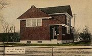
In 1906, Andrew Carnegie
awarded a grant of $2000 toward the construction of a Carnegie library
in Raymond, and in 1908 the Dudley-Tucker Library opened overlooking the Common.
, the town has a total area of 29.6 square miles (76.7 km²), of which 28.8 sq mi (74.6 km²) is land and 0.8 sq mi (2.1 km²) is water, comprising 2.67% of the town. Raymond is drained by the Lamprey River
. The highest point in town is Dumplingtown Hill, at 625 feet (190.5 m) above sea level
, located near the town's western border.
The central village of Raymond, a census-designated place
(CDP), has a total area of 4.8 square miles (12.4 km²), of which 4.6 sq mi (11.9 km²) is land and 0.1 sq mi (0.258998811 km²) (2.94%) is water.
The town is crossed by state routes 27
, 101
, 102
and 107
. It borders the towns of Deerfield
and Nottingham
to the north, Epping
and Fremont
to the east, Chester
to the south and Candia
to the west.
 As of the census
of 2000, there were 9,674 people, 3,493 households, and 2,567 families residing in the town. The population density
was 336.1 people per square mile (129.8/km²). There were 3,710 housing units at an average density of 128.9 per square mile (49.8/km²). The racial makeup of the town was 97.79% White, 0.56% Black or African American
, 0.24% Native American, 0.19% Asian, 0.05% Pacific Islander, 0.26% from other races
, and 0.92% from two or more races. Hispanic or Latino of any race were 0.79% of the population.
There were 3,493 households out of which 39.6% had children under the age of 18 living with them, 59.1% were married couples
living together, 9.5% had a female householder with no husband present, and 26.5% were non-families. 19.0% of all households were made up of individuals and 5.9% had someone living alone who was 65 years of age or older. The average household size was 2.77 and the average family size was 3.18.
 In the town the population was spread out with 29.2% under the age of 18, 7.6% from 18 to 24, 35.3% from 25 to 44, 21.1% from 45 to 64, and 6.9% who were 65 years of age or older. The median age was 34 years. For every 100 females there were 100.2 males. For every 100 females age 18 and over, there were 98.9 males.
The median income for a household in the town was $48,829, and the median income for a family was $50,889. Males had a median income of $35,493 versus $26,778 for females. The per capita income
for the town was $18,430. About 5.3% of families and 6.0% of the population were below the poverty line, including 7.8% of those under age 18 and 15.8% of those age 65 or over.
of 2000, there were 2,839 people, 1,116 households, and 738 families residing in the central village, or CDP. The population density
was 614.9 people per square mile (237.3/km²). There were 1,167 housing units at an average density of 252.8 per square mile (97.5/km²). The racial makeup of the CDP was 97.64% White, 0.39% Black or African American
, 0.32% Native American, 0.28% Asian, 0.11% from other races
, and 1.27% from two or more races. Hispanic or Latino of any race were 0.92% of the population.
There were 1,116 households out of which 34.9% had children under the age of 18 living with them, 50.8% were married couples
living together, 9.9% had a female householder with no husband present, and 33.8% were non-families. 24.6% of all households were made up of individuals and 8.9% had someone living alone who was 65 years of age or older. The average household size was 2.54 and the average family size was 3.06.
In the CDP the population was spread out with 26.3% under the age of 18, 9.3% from 18 to 24, 33.7% from 25 to 44, 21.2% from 45 to 64, and 9.4% who were 65 years of age or older. The median age was 34 years. For every 100 females there were 101.8 males. For every 100 females age 18 and over, there were 100.1 males.
The median income for a household in the CDP was $49,286, and the median income for a family was $51,371. Males had a median income of $35,750 versus $26,378 for females. The per capita income
for the CDP was $19,710. About 7.6% of families and 6.7% of the population were below the poverty line, including 5.8% of those under age 18 and 21.8% of those age 65 or over.
Rockingham County, New Hampshire
-Demographics:As of the census of 2000, there were 277,359 people, 104,529 households, and 74,320 families residing in the county. The population density was 399 people per square mile . There were 113,023 housing units at an average density of 163 per square mile...
, New Hampshire
New Hampshire
New Hampshire is a state in the New England region of the northeastern United States of America. The state was named after the southern English county of Hampshire. It is bordered by Massachusetts to the south, Vermont to the west, Maine and the Atlantic Ocean to the east, and the Canadian...
, United States
United States
The United States of America is a federal constitutional republic comprising fifty states and a federal district...
. The population was 10,138 at the 2010 census. Part of Pawtuckaway State Park
Pawtuckaway State Park
Pawtuckaway State Park is a preserve in New Hampshire, United States. It is one of the largest state parks in southeastern New Hampshire and is named for Pawtuckaway Lake and the Pawtuckaway Mountains...
is in the north.
The central village in town, where 2,855 people resided at the 2010 census, is defined as the Raymond census-designated place
Census-designated place
A census-designated place is a concentration of population identified by the United States Census Bureau for statistical purposes. CDPs are delineated for each decennial census as the statistical counterparts of incorporated places such as cities, towns and villages...
(CDP), and is located along the Lamprey River
Lamprey River
The Lamprey River is a 50.2 mile long river in southeastern New Hampshire, the United States. It rises in Meadow Lake in Northwood, and flows south, then generally east past Raymond, Epping, Lee and finally Newmarket...
near New Hampshire Route 27
New Hampshire Route 27
New Hampshire Route 27 is a long east–west highway in southeastern New Hampshire. The western terminus of NH 27 is in Hooksett at U.S. Route 3 and New Hampshire Route 28 north of Manchester...
.
History
This town was first settled by families from ExeterExeter, New Hampshire
Exeter is a town in Rockingham County, New Hampshire, United States. The town's population was 14,306 at the 2010 census. Exeter was the county seat until 1997, when county offices were moved to neighboring Brentwood...
as a parish
Parish
A parish is a territorial unit historically under the pastoral care and clerical jurisdiction of one parish priest, who might be assisted in his pastoral duties by a curate or curates - also priests but not the parish priest - from a more or less central parish church with its associated organization...
of Chester
Chester, New Hampshire
Chester is a town in Rockingham County, New Hampshire, United States. The population was 4,768 at the 2010 census. It is home to Chester College .-History:Incorporated in 1722, Chester once included Candia, set off in 1763...
, and known as Freetown because it was exempt from the usual obligation of reserving its tall pine
Eastern White Pine
Pinus strobus, commonly known as the eastern white pine, is a large pine native to eastern North America, occurring from Newfoundland west to Minnesota and southeastern Manitoba, and south along the Appalachian Mountains to the northern edge of Georgia.It is occasionally known as simply white pine,...
trees for masts
Mast (sailing)
The mast of a sailing vessel is a tall, vertical, or near vertical, spar, or arrangement of spars, which supports the sails. Large ships have several masts, with the size and configuration depending on the style of ship...
in the Royal English Navy. The town was incorporated in 1764 by Colonial
Colony
In politics and history, a colony is a territory under the immediate political control of a state. For colonies in antiquity, city-states would often found their own colonies. Some colonies were historically countries, while others were territories without definite statehood from their inception....
Governor Benning Wentworth
Benning Wentworth
Benning Wentworth was the colonial governor of New Hampshire from 1741 to 1766.-Biography:The eldest child of the John Wentworth who had been Lieutenant Governor, he was born and died in Portsmouth, New Hampshire. Wentworth graduated from Harvard College in 1715...
.
There are at least two theories regarding the source of the town's name. The earlier theory, stated by Joseph Fullonton in his History of Raymond, published 1875, is that the name was chosen as "a new and classical one." Fullonton relates that the original name of "Freetown" “arose from the ship timber business” where the king claimed the best trees. The locals had other ideas and took the trees and “being successful here, none molesting, they called it Freetown.” Fullonton states that at incorporation in 1764, changing the name from “Freetown” to “Raymond” was “taking a new and classical one, shows that there are minds not disposed to tread all the time in one path, but capable of thinking and advancing,” and that the word "Raymond" means “the lustrous, luminous or shining world.”
In a second theory, the town was named for Captain William Rayment, or Raymond, of Beverly, Massachusetts
Beverly, Massachusetts
Beverly is a city in Essex County, Massachusetts, United States. The population was 39,343 on , which differs by no more than several hundred from the 39,862 obtained in the 2000 census. A resort, residential and manufacturing community on the North Shore, Beverly includes Beverly Farms and Prides...
, who had raised a company of soldiers to fight in the war against Canada
Canada
Canada is a North American country consisting of ten provinces and three territories. Located in the northern part of the continent, it extends from the Atlantic Ocean in the east to the Pacific Ocean in the west, and northward into the Arctic Ocean...
in 1690. The Massachusetts General Court
Massachusetts General Court
The Massachusetts General Court is the state legislature of the Commonwealth of Massachusetts. The name "General Court" is a hold-over from the Colonial Era, when this body also sat in judgment of judicial appeals cases...
in 1735 granted Captain Raymond and his company a township called Beverly-Canada (now Weare
Weare, New Hampshire
Weare is a town in Hillsborough County, New Hampshire, United States. The population was 8,785 at the 2010 census. It is close to two important New Hampshire cities, Manchester and Concord.-History:...
) as payment for their services, but that claim was ruled invalid after New Hampshire separated from Massachusetts
Massachusetts
The Commonwealth of Massachusetts is a state in the New England region of the northeastern United States of America. It is bordered by Rhode Island and Connecticut to the south, New York to the west, and Vermont and New Hampshire to the north; at its east lies the Atlantic Ocean. As of the 2010...
in 1741. So in 1767, heirs of the veterans were instead awarded land in Maine
Maine
Maine is a state in the New England region of the northeastern United States, bordered by the Atlantic Ocean to the east and south, New Hampshire to the west, and the Canadian provinces of Quebec to the northwest and New Brunswick to the northeast. Maine is both the northernmost and easternmost...
. Originally called Raymondtown Plantation, it today comprises the towns of Raymond
Raymond, Maine
Raymond is a town in Cumberland County, Maine, United States. The population was 4,299 at the 2000 census. It is a summer recreation area and is part of the Portland–South Portland–Biddeford, Maine metropolitan statistical area...
, Casco
Casco, Maine
Farmers found the surface of the town uneven, its hard and rocky soil "tolerably productive." Outlets of ponds, however, provided Casco with good sites for water powered mills. The town had four sawmills, four gristmills, a shook mill, a barrel stave mill, four shingle factories, a carriage factory...
and part of Naples
Naples, Maine
Naples is a town in Cumberland County, Maine, United States. It is part of the Portland–South Portland–Biddeford, Maine metropolitan statistical area. The population was 3,274 at the 2000 census, and it is home to part of Sebago Lake State Park. Naples is a resort area.-History:The area...
.
In 1906, Andrew Carnegie
Andrew Carnegie
Andrew Carnegie was a Scottish-American industrialist, businessman, and entrepreneur who led the enormous expansion of the American steel industry in the late 19th century...
awarded a grant of $2000 toward the construction of a Carnegie library
Carnegie library
A Carnegie library is a library built with money donated by Scottish-American businessman and philanthropist Andrew Carnegie. 2,509 Carnegie libraries were built between 1883 and 1929, including some belonging to public and university library systems...
in Raymond, and in 1908 the Dudley-Tucker Library opened overlooking the Common.
Geography
According to the United States Census BureauUnited States Census Bureau
The United States Census Bureau is the government agency that is responsible for the United States Census. It also gathers other national demographic and economic data...
, the town has a total area of 29.6 square miles (76.7 km²), of which 28.8 sq mi (74.6 km²) is land and 0.8 sq mi (2.1 km²) is water, comprising 2.67% of the town. Raymond is drained by the Lamprey River
Lamprey River
The Lamprey River is a 50.2 mile long river in southeastern New Hampshire, the United States. It rises in Meadow Lake in Northwood, and flows south, then generally east past Raymond, Epping, Lee and finally Newmarket...
. The highest point in town is Dumplingtown Hill, at 625 feet (190.5 m) above sea level
Sea level
Mean sea level is a measure of the average height of the ocean's surface ; used as a standard in reckoning land elevation...
, located near the town's western border.
The central village of Raymond, a census-designated place
Census-designated place
A census-designated place is a concentration of population identified by the United States Census Bureau for statistical purposes. CDPs are delineated for each decennial census as the statistical counterparts of incorporated places such as cities, towns and villages...
(CDP), has a total area of 4.8 square miles (12.4 km²), of which 4.6 sq mi (11.9 km²) is land and 0.1 sq mi (0.258998811 km²) (2.94%) is water.
The town is crossed by state routes 27
New Hampshire Route 27
New Hampshire Route 27 is a long east–west highway in southeastern New Hampshire. The western terminus of NH 27 is in Hooksett at U.S. Route 3 and New Hampshire Route 28 north of Manchester...
, 101
New Hampshire Route 101
New Hampshire Route 101 is a state-maintained highway in southern New Hampshire extending from Keene to Hampton Beach. It is the major east–west highway in the southern portion of the state....
, 102
New Hampshire Route 102
New Hampshire Route 102 is a state highway in Rockingham and Hillsborough counties in the southern part of the U.S. state of New Hampshire. NH 102 runs southwest to northeast between Hudson and Raymond, but is signed as an east–west route.Some confusion exists over the western terminus...
and 107
New Hampshire Route 107
New Hampshire Route 107 is a long north–south state highway in New Hampshire. It connects Laconia in the Lakes Region with Seabrook on the Atlantic coast....
. It borders the towns of Deerfield
Deerfield, New Hampshire
Deerfield is a town in Rockingham County, New Hampshire, United States. The population was 4,280 at the 2010 census. Deerfield is home to the annual Deerfield Fair.- History :...
and Nottingham
Nottingham, New Hampshire
Nottingham is a town in Rockingham County, New Hampshire, United States. The population was 4,785 at the 2010 census. It is the location of Pawtuckaway State Park.-History:...
to the north, Epping
Epping, New Hampshire
Epping is a town in Rockingham County, New Hampshire, United States. The population was 6,411 at the 2010 census. Epping includes the area known as Camp Hedding....
and Fremont
Fremont, New Hampshire
Fremont is a town in Rockingham County, New Hampshire, United States. The population was 4,283 at the 2010 census. Fremont is crossed by the Rockingham Recreation Trail and NH Route 107.-History:...
to the east, Chester
Chester, New Hampshire
Chester is a town in Rockingham County, New Hampshire, United States. The population was 4,768 at the 2010 census. It is home to Chester College .-History:Incorporated in 1722, Chester once included Candia, set off in 1763...
to the south and Candia
Candia, New Hampshire
Candia is a town in Rockingham County, New Hampshire, United States. The population was 3,909 at the 2010 census. The town includes the villages of Candia, Candia Four Corners and East Candia.-History:...
to the west.
Demographics
Census
A census is the procedure of systematically acquiring and recording information about the members of a given population. It is a regularly occurring and official count of a particular population. The term is used mostly in connection with national population and housing censuses; other common...
of 2000, there were 9,674 people, 3,493 households, and 2,567 families residing in the town. The population density
Population density
Population density is a measurement of population per unit area or unit volume. It is frequently applied to living organisms, and particularly to humans...
was 336.1 people per square mile (129.8/km²). There were 3,710 housing units at an average density of 128.9 per square mile (49.8/km²). The racial makeup of the town was 97.79% White, 0.56% Black or African American
Race (United States Census)
Race and ethnicity in the United States Census, as defined by the Federal Office of Management and Budget and the United States Census Bureau, are self-identification data items in which residents choose the race or races with which they most closely identify, and indicate whether or not they are...
, 0.24% Native American, 0.19% Asian, 0.05% Pacific Islander, 0.26% from other races
Race (United States Census)
Race and ethnicity in the United States Census, as defined by the Federal Office of Management and Budget and the United States Census Bureau, are self-identification data items in which residents choose the race or races with which they most closely identify, and indicate whether or not they are...
, and 0.92% from two or more races. Hispanic or Latino of any race were 0.79% of the population.
There were 3,493 households out of which 39.6% had children under the age of 18 living with them, 59.1% were married couples
Marriage
Marriage is a social union or legal contract between people that creates kinship. It is an institution in which interpersonal relationships, usually intimate and sexual, are acknowledged in a variety of ways, depending on the culture or subculture in which it is found...
living together, 9.5% had a female householder with no husband present, and 26.5% were non-families. 19.0% of all households were made up of individuals and 5.9% had someone living alone who was 65 years of age or older. The average household size was 2.77 and the average family size was 3.18.
The median income for a household in the town was $48,829, and the median income for a family was $50,889. Males had a median income of $35,493 versus $26,778 for females. The per capita income
Per capita income
Per capita income or income per person is a measure of mean income within an economic aggregate, such as a country or city. It is calculated by taking a measure of all sources of income in the aggregate and dividing it by the total population...
for the town was $18,430. About 5.3% of families and 6.0% of the population were below the poverty line, including 7.8% of those under age 18 and 15.8% of those age 65 or over.
Town center
As of the censusCensus
A census is the procedure of systematically acquiring and recording information about the members of a given population. It is a regularly occurring and official count of a particular population. The term is used mostly in connection with national population and housing censuses; other common...
of 2000, there were 2,839 people, 1,116 households, and 738 families residing in the central village, or CDP. The population density
Population density
Population density is a measurement of population per unit area or unit volume. It is frequently applied to living organisms, and particularly to humans...
was 614.9 people per square mile (237.3/km²). There were 1,167 housing units at an average density of 252.8 per square mile (97.5/km²). The racial makeup of the CDP was 97.64% White, 0.39% Black or African American
Race (United States Census)
Race and ethnicity in the United States Census, as defined by the Federal Office of Management and Budget and the United States Census Bureau, are self-identification data items in which residents choose the race or races with which they most closely identify, and indicate whether or not they are...
, 0.32% Native American, 0.28% Asian, 0.11% from other races
Race (United States Census)
Race and ethnicity in the United States Census, as defined by the Federal Office of Management and Budget and the United States Census Bureau, are self-identification data items in which residents choose the race or races with which they most closely identify, and indicate whether or not they are...
, and 1.27% from two or more races. Hispanic or Latino of any race were 0.92% of the population.
There were 1,116 households out of which 34.9% had children under the age of 18 living with them, 50.8% were married couples
Marriage
Marriage is a social union or legal contract between people that creates kinship. It is an institution in which interpersonal relationships, usually intimate and sexual, are acknowledged in a variety of ways, depending on the culture or subculture in which it is found...
living together, 9.9% had a female householder with no husband present, and 33.8% were non-families. 24.6% of all households were made up of individuals and 8.9% had someone living alone who was 65 years of age or older. The average household size was 2.54 and the average family size was 3.06.
In the CDP the population was spread out with 26.3% under the age of 18, 9.3% from 18 to 24, 33.7% from 25 to 44, 21.2% from 45 to 64, and 9.4% who were 65 years of age or older. The median age was 34 years. For every 100 females there were 101.8 males. For every 100 females age 18 and over, there were 100.1 males.
The median income for a household in the CDP was $49,286, and the median income for a family was $51,371. Males had a median income of $35,750 versus $26,378 for females. The per capita income
Per capita income
Per capita income or income per person is a measure of mean income within an economic aggregate, such as a country or city. It is calculated by taking a measure of all sources of income in the aggregate and dividing it by the total population...
for the CDP was $19,710. About 7.6% of families and 6.7% of the population were below the poverty line, including 5.8% of those under age 18 and 21.8% of those age 65 or over.