
Epping, New Hampshire
Encyclopedia
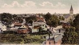
Epping is a town in Rockingham County
, New Hampshire
, United States
. The population was 6,411 at the 2010 census. Epping includes the area known as Camp Hedding.
The primary settlement in town, where 1,681 people resided at the 2010 census, is defined by the U.S. Census Bureau as the Epping census-designated place
(CDP) and includes the densely-populated portion of the town centered on New Hampshire Route 27
just west of New Hampshire Route 125
.
 The town was originally part of Exeter
, one of the four original New Hampshire townships. To encourage settlement, as early as 1710 Exeter awarded free wood lots in the area. In 1741, Epping was granted a charter and incorporated as a town, the last New Hampshire town chartered by Massachusetts
Governor Jonathan Belcher
before the Province of New Hampshire
separated from Massachusetts. Epping was named for Epping Forest
, a suburb of London
, England
.
Following the American Revolution
, many residents of the town moved to Monmouth, Maine
, when General Henry Dearborn
offered free land to his soldiers. Through the 1800s, farming was a principal occupation in Epping. The town also had substantial reserves of clay
, long used by local residents to make bricks, and in 1840, the first commercial brickyard was established in Epping.
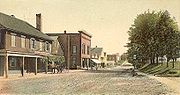
It was formerly said in jest: "Epping -- the center of the universe." Now, due to its strategic position at the crossroads
of Route 101
and Route 125, the community is indeed becoming a retail center, as chain store
s locate here. But because the traditional town center is clustered around Route 27
, an older road connecting Exeter with Hooksett
and Manchester
, Epping's antique architectural
charm has been spared from redevelopment
.
and Anne of Green Gables
. Musical lessons are also offered at this facility.
New England Dragway is also located in Epping and puts on races and auto displays throughout the year, including the IHRA
Amalie Oil North American Nationals. The dragway hosts a popular Halloween display during the second half of October.
An annual canoe race down the Lamprey River
occurs on the last weekend in April, and the fire department arranges for Santa to drive through the town atop a fire engine during the winter.
Camp Hedding, the site of a United Methodist campground founded in 1862, is located in the eastern part of town. The ground now hosts an annual camp meeting for one week in August and an "olde time fair" on the first Saturday of August every year.
, the town has a total area of 26.2 square miles (67.9 km²), of which 26 sq mi (67.3 km²) is land and 0.2 sq mi (0.517997622 km²) is water, comprising 0.76% of the town. Epping is drained by the Lamprey
and Piscassic
rivers. The highest point in Epping is Kennard Hill at 472 feet (143.9 m) above sea level
, located in the town's northwest corner. Epping lies fully within the Piscataqua River
(Coastal) watershed
.
The town center, defined as a census-designated place
(CDP), has a total area of 2.7 square miles (7 km²), all of it land.
, there were 5,476 people, 2,047 households, and 1,473 families residing in the town. The population density
was 210.4 persons per square mile (81.2/km²). There were 2,215 housing units at an average density of 85.1 houses per square mile (32.9/km²). The racial makeup of the town was 97.08% White, 0.27% African American
, 0.24% Native American, 0.44% Asia
n, 0.00% Pacific Islander, 0.15% from other races, and 1.83% from two or more races. 0.77% of the population were Hispanic
or Latino
of any race.
There were 2,047 households out of which 35.8% had children under the age of 18 living with them, 59.7% were married couples
living together, 8.5% have a woman whose husband does not live with her, and 28.0% were non-families. 21.1% of all households were made up of individuals and 7.1% had someone living alone who was 65 years of age or older. The average household size was 2.67 and the average family size was 3.12.
 In the town the population was spread out with 27.1% under the age of 18, 6.8% from 18 to 24, 34.6% from 25 to 44, 22.4% from 45 to 64, and 9.2% who were 65 years of age or older. The median age was 36 years. For every 100 females there were 97.2 males. For every 100 females age 18 and over, there were 95.8 males.
The median income for a household in the town was $50,739, and the median income for a family was $54,722. Males had a median income of $40,273 versus $25,440 for females. The per capita income
for the town was $21,109. 3.3% of the population and 2.6% of families were below the poverty line. Out of the total people living in poverty, 4.6% are under the age of 18 and 6.1% are 65 or older.
of 2000, there were 1,673 people, 703 households, and 440 families residing in the central village, or census-designated place
(CDP). The population density
was 622.5 people per square mile (240.1/km²). There were 723 housing units at an average density of 103.8 persons/km² (269.0 persons/sq mi). The racial makeup of the town was 97.31% White, 0.30% African American
, 0.12% Native American, 0.78% Asia
n, and 1.49% from two or more races. 0.12% of the population were Hispanic
or Latino
of any race.
There were 703 households out of which 28.9% had children under the age of 18 living with them, 49.8% were married couples
living together, 9.0% have a woman whose husband does not live with her, and 37.4% were non-families. 30.6% of all households were made up of individuals and 12.5% had someone living alone who was 65 years of age or older. The average household size was 2.37 and the average family size was 2.97.
In the CDP the population was spread out with 23.9% under the age of 18, 7.3% from 18 to 24, 30.1% from 25 to 44, 21.6% from 45 to 64, and 17.1% who were 65 years of age or older. The median age was 38 years. For every 100 females there were 94.3 males. For every 100 females age 18 and over, there were 92.3 males.
The median income for a household is $39,417, and the median income for a family was $46,438. Males had a median income of $36,165 versus $24,063 for females. The per capita income
for the town was $18,343. 6.7% of the population and 5.6% of families were below the poverty line. Out of the total people living in poverty, 8.6% are under the age of 18 and 11.7% are 65 or older.
Rockingham County, New Hampshire
-Demographics:As of the census of 2000, there were 277,359 people, 104,529 households, and 74,320 families residing in the county. The population density was 399 people per square mile . There were 113,023 housing units at an average density of 163 per square mile...
, New Hampshire
New Hampshire
New Hampshire is a state in the New England region of the northeastern United States of America. The state was named after the southern English county of Hampshire. It is bordered by Massachusetts to the south, Vermont to the west, Maine and the Atlantic Ocean to the east, and the Canadian...
, United States
United States
The United States of America is a federal constitutional republic comprising fifty states and a federal district...
. The population was 6,411 at the 2010 census. Epping includes the area known as Camp Hedding.
The primary settlement in town, where 1,681 people resided at the 2010 census, is defined by the U.S. Census Bureau as the Epping census-designated place
Census-designated place
A census-designated place is a concentration of population identified by the United States Census Bureau for statistical purposes. CDPs are delineated for each decennial census as the statistical counterparts of incorporated places such as cities, towns and villages...
(CDP) and includes the densely-populated portion of the town centered on New Hampshire Route 27
New Hampshire Route 27
New Hampshire Route 27 is a long east–west highway in southeastern New Hampshire. The western terminus of NH 27 is in Hooksett at U.S. Route 3 and New Hampshire Route 28 north of Manchester...
just west of New Hampshire Route 125
New Hampshire Route 125
New Hampshire Route 125 is a long north–south state highway in Rockingham and Strafford counties in southeastern New Hampshire. It runs from Plaistow to just north of Milton...
.
History
Exeter, New Hampshire
Exeter is a town in Rockingham County, New Hampshire, United States. The town's population was 14,306 at the 2010 census. Exeter was the county seat until 1997, when county offices were moved to neighboring Brentwood...
, one of the four original New Hampshire townships. To encourage settlement, as early as 1710 Exeter awarded free wood lots in the area. In 1741, Epping was granted a charter and incorporated as a town, the last New Hampshire town chartered by Massachusetts
Massachusetts
The Commonwealth of Massachusetts is a state in the New England region of the northeastern United States of America. It is bordered by Rhode Island and Connecticut to the south, New York to the west, and Vermont and New Hampshire to the north; at its east lies the Atlantic Ocean. As of the 2010...
Governor Jonathan Belcher
Jonathan Belcher
Jonathan Belcher was colonial governor of the British provinces of Massachusetts Bay, New Hampshire, and New Jersey.-Early life:Jonathan Belcher was born in Cambridge, Province of Massachusetts Bay, in 1682...
before the Province of New Hampshire
Province of New Hampshire
The Province of New Hampshire is a name first given in 1629 to the territory between the Merrimack and Piscataqua rivers on the eastern coast of North America. It was formally organized as an English royal colony on October 7, 1691, during the period of English colonization...
separated from Massachusetts. Epping was named for Epping Forest
Epping Forest
Epping Forest is an area of ancient woodland in south-east England, straddling the border between north-east Greater London and Essex. It is a former royal forest, and is managed by the City of London Corporation....
, a suburb of London
London
London is the capital city of :England and the :United Kingdom, the largest metropolitan area in the United Kingdom, and the largest urban zone in the European Union by most measures. Located on the River Thames, London has been a major settlement for two millennia, its history going back to its...
, England
England
England is a country that is part of the United Kingdom. It shares land borders with Scotland to the north and Wales to the west; the Irish Sea is to the north west, the Celtic Sea to the south west, with the North Sea to the east and the English Channel to the south separating it from continental...
.
Following the American Revolution
American Revolution
The American Revolution was the political upheaval during the last half of the 18th century in which thirteen colonies in North America joined together to break free from the British Empire, combining to become the United States of America...
, many residents of the town moved to Monmouth, Maine
Monmouth, Maine
Monmouth is a town in Kennebec County, Maine, United States. The population was 3,785 at the 2000 census. It is a popular summer resort area, with many lakeside cottages.-History:...
, when General Henry Dearborn
Henry Dearborn
Henry Dearborn was an American physician, a statesman and a veteran of both the American Revolutionary War and the War of 1812. Born to Simon Dearborn and Sarah Marston in North Hampton, New Hampshire, he spent much of his youth in Epping, where he attended public schools...
offered free land to his soldiers. Through the 1800s, farming was a principal occupation in Epping. The town also had substantial reserves of clay
Clay
Clay is a general term including many combinations of one or more clay minerals with traces of metal oxides and organic matter. Geologic clay deposits are mostly composed of phyllosilicate minerals containing variable amounts of water trapped in the mineral structure.- Formation :Clay minerals...
, long used by local residents to make bricks, and in 1840, the first commercial brickyard was established in Epping.
It was formerly said in jest: "Epping -- the center of the universe." Now, due to its strategic position at the crossroads
Crossroads (culture)
In folk magic and mythology, crossroads may represent a location "between the worlds" and, as such, a site where supernatural spirits can be contacted and paranormal events can take place...
of Route 101
New Hampshire Route 101
New Hampshire Route 101 is a state-maintained highway in southern New Hampshire extending from Keene to Hampton Beach. It is the major east–west highway in the southern portion of the state....
and Route 125, the community is indeed becoming a retail center, as chain store
Chain store
Chain stores are retail outlets that share a brand and central management, and usually have standardized business methods and practices. These characteristics also apply to chain restaurants and some service-oriented chain businesses. In retail, dining and many service categories, chain businesses...
s locate here. But because the traditional town center is clustered around Route 27
New Hampshire Route 27
New Hampshire Route 27 is a long east–west highway in southeastern New Hampshire. The western terminus of NH 27 is in Hooksett at U.S. Route 3 and New Hampshire Route 28 north of Manchester...
, an older road connecting Exeter with Hooksett
Hooksett, New Hampshire
Hooksett is a town in Merrimack County, New Hampshire, United States. The population was 13,451 at the 2010 census. The town is located between Manchester, the state's largest city, and Concord, the state capital...
and Manchester
Manchester, New Hampshire
Manchester is the largest city in the U.S. state of New Hampshire, the tenth largest city in New England, and the largest city in northern New England, an area comprising the states of Maine, New Hampshire, and Vermont. It is in Hillsborough County along the banks of the Merrimack River, which...
, Epping's antique architectural
Architecture
Architecture is both the process and product of planning, designing and construction. Architectural works, in the material form of buildings, are often perceived as cultural and political symbols and as works of art...
charm has been spared from redevelopment
Redevelopment
Redevelopment is any new construction on a site that has pre-existing uses.-Description:Variations on redevelopment include:* Urban infill on vacant parcels that have no existing activity but were previously developed, especially on Brownfield land, such as the redevelopment of an industrial site...
.
Culture
Epping is home to the Leddy Center, an antique playhouse where local performers present classics such as The Wizard of OzThe Wizard of Oz (adaptations)
The Wonderful Wizard of Oz is a 1900 novel by L. Frank Baum, which has been adapted into several different works, the most famous being the 1939 film The Wizard of Oz, starring Judy Garland...
and Anne of Green Gables
Anne of Green Gables
Anne of Green Gables is a bestselling novel by Canadian author Lucy Maud Montgomery published in 1908. Set in 1878, it was written as fiction for readers of all ages, but in recent decades has been considered a children's book...
. Musical lessons are also offered at this facility.
New England Dragway is also located in Epping and puts on races and auto displays throughout the year, including the IHRA
International Hot Rod Association
The International Hot Rod Association, also known as IHRA, is the 2nd largest drag racing sanctioning body after the NHRA.-The Carrier Era:The IHRA was formed in November 1970 by businessman Larry Carrier. Throughout this period the organization was operated primarily in the south-eastern United...
Amalie Oil North American Nationals. The dragway hosts a popular Halloween display during the second half of October.
An annual canoe race down the Lamprey River
Lamprey River
The Lamprey River is a 50.2 mile long river in southeastern New Hampshire, the United States. It rises in Meadow Lake in Northwood, and flows south, then generally east past Raymond, Epping, Lee and finally Newmarket...
occurs on the last weekend in April, and the fire department arranges for Santa to drive through the town atop a fire engine during the winter.
Camp Hedding, the site of a United Methodist campground founded in 1862, is located in the eastern part of town. The ground now hosts an annual camp meeting for one week in August and an "olde time fair" on the first Saturday of August every year.
Notable inhabitants
- Kerry BascomKerry BascomKerry Bascom is a retired basketball player. She played forward and center for the Connecticut Huskies from 1987–1991, scoring 2,177 points, a school record until broken in 1998 by Nykesha Sales...
, record-setting women's basketball player for the University of Connecticut - David L. MorrilDavid L. MorrilDavid Lawrence Morril graduated from Dartmouth College and later received his law degree from the University of Vermont. He was an American physician and clergyman and lived for a time in Goffstown, New Hampshire. He served as a U.S...
, Governor of New Hampshire (1824–1827) - William PlumerWilliam PlumerWilliam Plumer was an American lawyer and Baptist lay preacher from Epping, New Hampshire. Born in 1759 in Newburyport, Massachusetts, he represented New Hampshire as a Federalist in the United States Senate from June 17, 1802 to March 4, 1807...
, Governor of New Hampshire (1812–1813 and 1816–1819) - Benjamin Franklin Prescott, Governor of New Hampshire (1877–1879)
Geography
According to the United States Census BureauUnited States Census Bureau
The United States Census Bureau is the government agency that is responsible for the United States Census. It also gathers other national demographic and economic data...
, the town has a total area of 26.2 square miles (67.9 km²), of which 26 sq mi (67.3 km²) is land and 0.2 sq mi (0.517997622 km²) is water, comprising 0.76% of the town. Epping is drained by the Lamprey
Lamprey River
The Lamprey River is a 50.2 mile long river in southeastern New Hampshire, the United States. It rises in Meadow Lake in Northwood, and flows south, then generally east past Raymond, Epping, Lee and finally Newmarket...
and Piscassic
Piscassic River
The Piscassic River is a 15.3 mile long river located in southeastern New Hampshire in the United States. It is a tributary of the Lamprey River, part of the Great Bay and Piscataqua River watershed leading to the Atlantic Ocean....
rivers. The highest point in Epping is Kennard Hill at 472 feet (143.9 m) above sea level
Sea level
Mean sea level is a measure of the average height of the ocean's surface ; used as a standard in reckoning land elevation...
, located in the town's northwest corner. Epping lies fully within the Piscataqua River
Piscataqua River
The Piscataqua River, in the northeastern United States, is a long tidal estuary formed by the confluence of the Salmon Falls and Cocheco rivers...
(Coastal) watershed
Drainage basin
A drainage basin is an extent or an area of land where surface water from rain and melting snow or ice converges to a single point, usually the exit of the basin, where the waters join another waterbody, such as a river, lake, reservoir, estuary, wetland, sea, or ocean...
.
The town center, defined as a census-designated place
Census-designated place
A census-designated place is a concentration of population identified by the United States Census Bureau for statistical purposes. CDPs are delineated for each decennial census as the statistical counterparts of incorporated places such as cities, towns and villages...
(CDP), has a total area of 2.7 square miles (7 km²), all of it land.
Demographics
As of the 2000 censusCensus
A census is the procedure of systematically acquiring and recording information about the members of a given population. It is a regularly occurring and official count of a particular population. The term is used mostly in connection with national population and housing censuses; other common...
, there were 5,476 people, 2,047 households, and 1,473 families residing in the town. The population density
Population density
Population density is a measurement of population per unit area or unit volume. It is frequently applied to living organisms, and particularly to humans...
was 210.4 persons per square mile (81.2/km²). There were 2,215 housing units at an average density of 85.1 houses per square mile (32.9/km²). The racial makeup of the town was 97.08% White, 0.27% African American
African American
African Americans are citizens or residents of the United States who have at least partial ancestry from any of the native populations of Sub-Saharan Africa and are the direct descendants of enslaved Africans within the boundaries of the present United States...
, 0.24% Native American, 0.44% Asia
Asia
Asia is the world's largest and most populous continent, located primarily in the eastern and northern hemispheres. It covers 8.7% of the Earth's total surface area and with approximately 3.879 billion people, it hosts 60% of the world's current human population...
n, 0.00% Pacific Islander, 0.15% from other races, and 1.83% from two or more races. 0.77% of the population were Hispanic
Hispanic
Hispanic is a term that originally denoted a relationship to Hispania, which is to say the Iberian Peninsula: Andorra, Gibraltar, Portugal and Spain. During the Modern Era, Hispanic sometimes takes on a more limited meaning, particularly in the United States, where the term means a person of ...
or Latino
Latino
The demonyms Latino and Latina , are defined in English language dictionaries as:* "a person of Latin-American descent."* "A Latin American."* "A person of Hispanic, especially Latin-American, descent, often one living in the United States."...
of any race.
There were 2,047 households out of which 35.8% had children under the age of 18 living with them, 59.7% were married couples
Marriage
Marriage is a social union or legal contract between people that creates kinship. It is an institution in which interpersonal relationships, usually intimate and sexual, are acknowledged in a variety of ways, depending on the culture or subculture in which it is found...
living together, 8.5% have a woman whose husband does not live with her, and 28.0% were non-families. 21.1% of all households were made up of individuals and 7.1% had someone living alone who was 65 years of age or older. The average household size was 2.67 and the average family size was 3.12.
The median income for a household in the town was $50,739, and the median income for a family was $54,722. Males had a median income of $40,273 versus $25,440 for females. The per capita income
Per capita income
Per capita income or income per person is a measure of mean income within an economic aggregate, such as a country or city. It is calculated by taking a measure of all sources of income in the aggregate and dividing it by the total population...
for the town was $21,109. 3.3% of the population and 2.6% of families were below the poverty line. Out of the total people living in poverty, 4.6% are under the age of 18 and 6.1% are 65 or older.
Town center
As of the censusCensus
A census is the procedure of systematically acquiring and recording information about the members of a given population. It is a regularly occurring and official count of a particular population. The term is used mostly in connection with national population and housing censuses; other common...
of 2000, there were 1,673 people, 703 households, and 440 families residing in the central village, or census-designated place
Census-designated place
A census-designated place is a concentration of population identified by the United States Census Bureau for statistical purposes. CDPs are delineated for each decennial census as the statistical counterparts of incorporated places such as cities, towns and villages...
(CDP). The population density
Population density
Population density is a measurement of population per unit area or unit volume. It is frequently applied to living organisms, and particularly to humans...
was 622.5 people per square mile (240.1/km²). There were 723 housing units at an average density of 103.8 persons/km² (269.0 persons/sq mi). The racial makeup of the town was 97.31% White, 0.30% African American
African American
African Americans are citizens or residents of the United States who have at least partial ancestry from any of the native populations of Sub-Saharan Africa and are the direct descendants of enslaved Africans within the boundaries of the present United States...
, 0.12% Native American, 0.78% Asia
Asia
Asia is the world's largest and most populous continent, located primarily in the eastern and northern hemispheres. It covers 8.7% of the Earth's total surface area and with approximately 3.879 billion people, it hosts 60% of the world's current human population...
n, and 1.49% from two or more races. 0.12% of the population were Hispanic
Hispanic
Hispanic is a term that originally denoted a relationship to Hispania, which is to say the Iberian Peninsula: Andorra, Gibraltar, Portugal and Spain. During the Modern Era, Hispanic sometimes takes on a more limited meaning, particularly in the United States, where the term means a person of ...
or Latino
Latino
The demonyms Latino and Latina , are defined in English language dictionaries as:* "a person of Latin-American descent."* "A Latin American."* "A person of Hispanic, especially Latin-American, descent, often one living in the United States."...
of any race.
There were 703 households out of which 28.9% had children under the age of 18 living with them, 49.8% were married couples
Marriage
Marriage is a social union or legal contract between people that creates kinship. It is an institution in which interpersonal relationships, usually intimate and sexual, are acknowledged in a variety of ways, depending on the culture or subculture in which it is found...
living together, 9.0% have a woman whose husband does not live with her, and 37.4% were non-families. 30.6% of all households were made up of individuals and 12.5% had someone living alone who was 65 years of age or older. The average household size was 2.37 and the average family size was 2.97.
In the CDP the population was spread out with 23.9% under the age of 18, 7.3% from 18 to 24, 30.1% from 25 to 44, 21.6% from 45 to 64, and 17.1% who were 65 years of age or older. The median age was 38 years. For every 100 females there were 94.3 males. For every 100 females age 18 and over, there were 92.3 males.
The median income for a household is $39,417, and the median income for a family was $46,438. Males had a median income of $36,165 versus $24,063 for females. The per capita income
Per capita income
Per capita income or income per person is a measure of mean income within an economic aggregate, such as a country or city. It is calculated by taking a measure of all sources of income in the aggregate and dividing it by the total population...
for the town was $18,343. 6.7% of the population and 5.6% of families were below the poverty line. Out of the total people living in poverty, 8.6% are under the age of 18 and 11.7% are 65 or older.