
Northwood, New Hampshire
Encyclopedia
Northwood is a town in Rockingham County
, New Hampshire
, United States
. The population was 4,241 at the 2010 census.
 First settled in 1763, Northwood was incorporated on February 6, 1773 by Colonial
Governor John Wentworth
, when a large tract of land called "North Woods" was separated from Nottingham
. Around 1800, the Portsmouth
to Concord
Turnpike was built, and the town began to prosper. Numerous tavern
s accommodated sledge and stage
passengers. At one time, there were some 12 sawmills
in the town, 5 of which were replaced by shoe factories during the latter half of the 19th century. By 1920, however, the last shoe factory had closed. More recently, the town has been a popular vacation spot, being home to 9 lakes and many antique shops.
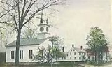
Four Northwood districts along Route 4 are considered historic sections of town. They are, from east to west, East Northwood, Northwood Ridge, Northwood Center and Northwood Narrows. The town is home to Coe-Brown Northwood Academy, founded in 1867.
, the town has a total area of 30 square miles (77.7 km²), of which 28 sq mi (72.5 km²) is land and 2.1 sq mi (5.4 km²) is water, comprising 6.89% of the town. Northwood is well known for its lakes, with both seasonal and year-round residences. The larger lakes and ponds include Bow Lake
, which is part of the Piscataqua River
drainage basin, and Northwood Lake
, Pleasant Lake
, Jenness Pond
, Harvey Lake, and Long Pond, all of which drain to the Suncook River
, a tributary of the Merrimack River
. The highest point in Northwood is Saddleback Mountain, at 1150 feet (350.5 m) above sea level
.
with many various flora
and fauna
. The climate of Northwood is a temperate
, humid continental climate
, with warm summers and cold, snowy winters. Some of the flora and fauna that can be seen in Northwood are as follows.
 As of the census
of 2000, there were 3,640 people, 1,347 households, and 1,000 families residing in the town. The population density
was 130.1 people per square mile (50.2/km²). There were 1,905 housing units at an average density of 68.1 per square mile (26.3/km²). The racial makeup of the town was 97.53% White, 0.30% African American, 0.30% Native American, 0.66% Asian, 0.14% Pacific Islander, 0.19% from other races
, and 0.88% from two or more races. Hispanic or Latino of any race were 0.55% of the population.
There were 1,347 households out of which 36.7% had children under the age of 18 living with them, 62.0% were married couples
living together, 7.7% had a female householder with no husband present, and 25.7% were non-families. 18.0% of all households were made up of individuals and 5.1% had someone living alone who was 65 years of age or older. The average household size was 2.70 and the average family size was 3.07.
 In the town the population was spread out with 27.1% under the age of 18, 6.6% from 18 to 24, 32.1% from 25 to 44, 25.2% from 45 to 64, and 9.0% who were 65 years of age or older. The median age was 37 years. For every 100 females there were 100.3 males. For every 100 females age 18 and over, there were 99.3 males.
The median income for a household in the town was $50,675, and the median income for a family was $53,953. Males had a median income of $36,161 versus $27,721 for females. The per capita income
for the town was $21,491. About 1.5% of families and 4.2% of the population were below the poverty line, including 3.0% of those under age 18 and 3.0% of those age 65 or over.
, a Jewish summer camp on Lucas Pond, and Wah-Tut-Ca Scout Reservation, a Boy Scout Camp run by the Yankee Clipper Council.
Rockingham County, New Hampshire
-Demographics:As of the census of 2000, there were 277,359 people, 104,529 households, and 74,320 families residing in the county. The population density was 399 people per square mile . There were 113,023 housing units at an average density of 163 per square mile...
, New Hampshire
New Hampshire
New Hampshire is a state in the New England region of the northeastern United States of America. The state was named after the southern English county of Hampshire. It is bordered by Massachusetts to the south, Vermont to the west, Maine and the Atlantic Ocean to the east, and the Canadian...
, United States
United States
The United States of America is a federal constitutional republic comprising fifty states and a federal district...
. The population was 4,241 at the 2010 census.
History
Colony
In politics and history, a colony is a territory under the immediate political control of a state. For colonies in antiquity, city-states would often found their own colonies. Some colonies were historically countries, while others were territories without definite statehood from their inception....
Governor John Wentworth
John Wentworth (governor)
Sir John Wentworth, 1st Baronet was the British colonial governor of New Hampshire at the time of the American Revolution. He was later also Lieutenant-Governor of Nova Scotia.-Early life:...
, when a large tract of land called "North Woods" was separated from Nottingham
Nottingham, New Hampshire
Nottingham is a town in Rockingham County, New Hampshire, United States. The population was 4,785 at the 2010 census. It is the location of Pawtuckaway State Park.-History:...
. Around 1800, the Portsmouth
Portsmouth, New Hampshire
Portsmouth is a city in Rockingham County, New Hampshire in the United States. It is the largest city but only the fourth-largest community in the county, with a population of 21,233 at the 2010 census...
to Concord
Concord, New Hampshire
The city of Concord is the capital of the state of New Hampshire in the United States. It is also the county seat of Merrimack County. As of the 2010 census, its population was 42,695....
Turnpike was built, and the town began to prosper. Numerous tavern
Tavern
A tavern is a place of business where people gather to drink alcoholic beverages and be served food, and in some cases, where travelers receive lodging....
s accommodated sledge and stage
Stagecoach
A stagecoach is a type of covered wagon for passengers and goods, strongly sprung and drawn by four horses, usually four-in-hand. Widely used before the introduction of railway transport, it made regular trips between stages or stations, which were places of rest provided for stagecoach travelers...
passengers. At one time, there were some 12 sawmills
Sawmills
Sawmills may refer to:* A sawmill, a facility where logs are cut to length* Sawmills Studio, a famous UK music recording studio* Sawmills, North Carolina...
in the town, 5 of which were replaced by shoe factories during the latter half of the 19th century. By 1920, however, the last shoe factory had closed. More recently, the town has been a popular vacation spot, being home to 9 lakes and many antique shops.
Four Northwood districts along Route 4 are considered historic sections of town. They are, from east to west, East Northwood, Northwood Ridge, Northwood Center and Northwood Narrows. The town is home to Coe-Brown Northwood Academy, founded in 1867.
Notable inhabitants
- Ella Knowles, suffragist, lawyer and politician, born in Northwood in 1860
Geography
According to the United States Census BureauUnited States Census Bureau
The United States Census Bureau is the government agency that is responsible for the United States Census. It also gathers other national demographic and economic data...
, the town has a total area of 30 square miles (77.7 km²), of which 28 sq mi (72.5 km²) is land and 2.1 sq mi (5.4 km²) is water, comprising 6.89% of the town. Northwood is well known for its lakes, with both seasonal and year-round residences. The larger lakes and ponds include Bow Lake
Bow Lake (New Hampshire)
Bow Lake is a water body located in Strafford and Rockingham counties in eastern New Hampshire, United States, in the towns of Strafford and Northwood. Its outlet is the Isinglass River, flowing east to the Atlantic Ocean via the Cocheco and Piscataqua rivers....
, which is part of the Piscataqua River
Piscataqua River
The Piscataqua River, in the northeastern United States, is a long tidal estuary formed by the confluence of the Salmon Falls and Cocheco rivers...
drainage basin, and Northwood Lake
Northwood Lake
Northwood Lake is a water body located in Rockingham and Merrimack counties in central New Hampshire, United States, in the towns of Northwood and Epsom...
, Pleasant Lake
Pleasant Lake (Deerfield, New Hampshire)
Pleasant Lake is a lake located in Rockingham County in central New Hampshire, United States, in the town of Deerfield. The eastern shore of the lake forms the boundary between Deerfield and the town of Northwood. Water from Pleasant Lake flows north to Northwood Lake, then west via the Little...
, Jenness Pond
Jenness Pond
Jenness Pond is a water body located primarily in Rockingham County in southern New Hampshire, United States, in the town of Northwood. A small portion of the pond at its northwest end lies in Pittsfield in Merrimack County...
, Harvey Lake, and Long Pond, all of which drain to the Suncook River
Suncook River
The Suncook River is a river located in central New Hampshire in the United States. It is a tributary of the Merrimack River, which flows to the Gulf of Maine....
, a tributary of the Merrimack River
Merrimack River
The Merrimack River is a river in the northeastern United States. It rises at the confluence of the Pemigewasset and Winnipesaukee rivers in Franklin, New Hampshire, flows southward into Massachusetts, and then flows northeast until it empties into the Atlantic Ocean at Newburyport...
. The highest point in Northwood is Saddleback Mountain, at 1150 feet (350.5 m) above sea level
Sea level
Mean sea level is a measure of the average height of the ocean's surface ; used as a standard in reckoning land elevation...
.
Ecosystem
Northwood has a diverse ecosystemEcosystem
An ecosystem is a biological environment consisting of all the organisms living in a particular area, as well as all the nonliving , physical components of the environment with which the organisms interact, such as air, soil, water and sunlight....
with many various flora
Flora
Flora is the plant life occurring in a particular region or time, generally the naturally occurring or indigenous—native plant life. The corresponding term for animals is fauna.-Etymology:...
and fauna
Fauna
Fauna or faunæ is all of the animal life of any particular region or time. The corresponding term for plants is flora.Zoologists and paleontologists use fauna to refer to a typical collection of animals found in a specific time or place, e.g. the "Sonoran Desert fauna" or the "Burgess shale fauna"...
. The climate of Northwood is a temperate
Temperate
In geography, temperate or tepid latitudes of the globe lie between the tropics and the polar circles. The changes in these regions between summer and winter are generally relatively moderate, rather than extreme hot or cold...
, humid continental climate
Humid continental climate
A humid continental climate is a climatic region typified by large seasonal temperature differences, with warm to hot summers and cold winters....
, with warm summers and cold, snowy winters. Some of the flora and fauna that can be seen in Northwood are as follows.
Demographics
Census
A census is the procedure of systematically acquiring and recording information about the members of a given population. It is a regularly occurring and official count of a particular population. The term is used mostly in connection with national population and housing censuses; other common...
of 2000, there were 3,640 people, 1,347 households, and 1,000 families residing in the town. The population density
Population density
Population density is a measurement of population per unit area or unit volume. It is frequently applied to living organisms, and particularly to humans...
was 130.1 people per square mile (50.2/km²). There were 1,905 housing units at an average density of 68.1 per square mile (26.3/km²). The racial makeup of the town was 97.53% White, 0.30% African American, 0.30% Native American, 0.66% Asian, 0.14% Pacific Islander, 0.19% from other races
Race (United States Census)
Race and ethnicity in the United States Census, as defined by the Federal Office of Management and Budget and the United States Census Bureau, are self-identification data items in which residents choose the race or races with which they most closely identify, and indicate whether or not they are...
, and 0.88% from two or more races. Hispanic or Latino of any race were 0.55% of the population.
There were 1,347 households out of which 36.7% had children under the age of 18 living with them, 62.0% were married couples
Marriage
Marriage is a social union or legal contract between people that creates kinship. It is an institution in which interpersonal relationships, usually intimate and sexual, are acknowledged in a variety of ways, depending on the culture or subculture in which it is found...
living together, 7.7% had a female householder with no husband present, and 25.7% were non-families. 18.0% of all households were made up of individuals and 5.1% had someone living alone who was 65 years of age or older. The average household size was 2.70 and the average family size was 3.07.
The median income for a household in the town was $50,675, and the median income for a family was $53,953. Males had a median income of $36,161 versus $27,721 for females. The per capita income
Per capita income
Per capita income or income per person is a measure of mean income within an economic aggregate, such as a country or city. It is calculated by taking a measure of all sources of income in the aggregate and dividing it by the total population...
for the town was $21,491. About 1.5% of families and 4.2% of the population were below the poverty line, including 3.0% of those under age 18 and 3.0% of those age 65 or over.
Camps
Northwood is home to Camp YavnehCamp Yavneh
Camp Yavneh is a residential Jewish camp established in 1944 and affiliated with Hebrew College. The camp is accredited by the American Camp Association and is located in Northwood, New Hampshire, in the United States....
, a Jewish summer camp on Lucas Pond, and Wah-Tut-Ca Scout Reservation, a Boy Scout Camp run by the Yankee Clipper Council.
Further reading
- Bailey, J.W. (1992) A Guide to the History and Old Dwelling Places of Northwood, New Hampshire, Second Edition, Peter E. Randall Publisher, Portsmouth, NH, 305 pp.