
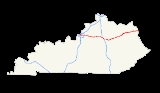
Interstate 64 in Kentucky
Encyclopedia
In the U.S. state
of Kentucky
, Interstate 64
travels for 191 miles (307.4 km) passing by the major towns and cities of Louisville
, Frankfort
, Lexington
and Ashland
. It has several major junctions within the state: Interstate 65
, Interstate 71
, Interstate 264
and Interstate 265
in Louisville, and Interstate 75
in Lexington.
The interstate is host to two "exceptionally significant" structures indicated by the Federal Highway Administration
. One is the Cochran Hill Tunnel, a twin tube at Cherokee Park
in Louisville built in 1974, and the other is a 1960s-era modern-styled rest area near Winchester
.
In Downtown Louisville
, the interstate passes under a public plaza called the Riverfront Plaza/Belvedere
, one of the only structures in the state built on top of an interstate.
Tunnel, underwent restoration in 2001, which involved the reconstruction of the concrete pavement
, the installation of new tiles and improvements to lighting. Efforts were made to paint the interior tiles of the tunnel with a mural, but were dropped because opponents stated that drivers would become distracted while passing through the tunnel, driving and viewing the art work at the same time. The tunnels, which opened in 1974, are one of three sites in Kentucky deemed "exceptionally significant" by the Federal Highway Administration
. The designation meant that it will be very difficult for the stretch of interstate running through Cherokee Park ever to be widened.
Construction began on a Kentucky Route 180 interchange improvement project in the summer of 2006. The $34 million project entailed the rebuilding of six bridges, the widening of Kentucky Route 180 to four-lanes in the vicinity of the interchange and the conversion of the ramps into a diamond
. The project should be finished by November 2008.
 In March 2007, Governor
Ernie Fletcher
signed Senate Bill 83 which allowed for an increase in speed limits on rural interstates and parkways. Speed limits on rural
sections of Interstate 64 were increased from 65 MPH to 70 mi/h, following an engineering study by the Kentucky Transportation Cabinet
. New signage was installed in July
On June 7, 2007, Interstate 64 between the junction of Interstate 264
and Interstate 65
and Interstate 71
in downtown Louisville
was closed to through traffic. The section of highway featured three-lanes of traffic in each direction on an elevated viaduct
paralleling the Ohio River
, carrying 90,000 vehicles-per-day. The closure was part of a $50 million refurbishment project that involved replacing 132 expansion joint
s and repaving more than four-miles (6 km) of interstate and interchanges. The work was completed in two phases, starting with the entire project area being closed on three weekends in June, followed by a section of highway closed from 3rd to 22nd Streets in early July to early August. However, the Interstate was not finished because of the section between Frankfort and Lexington. The state could not attain the right of way here because of very famous horse parks northwest of Lexington. After a couple of tries to get the right of way, the state was able to get the right of way and began construction on this segment. It was the last segment of Interstate 64 to be completed in Kentucky
, a key part of the revitalization of Downtown Louisville
, and portions of the park exist under it. 8664.org
, a grassroots campaign with popular support but little apparent political momentum, aims to re-route I-64 to enhance Louisville's waterfront. I-64 will be widened over the park as a part of the Ohio River Bridges Project
, supported by the Mayor and most involved in city and interstate planning.
U.S. state
A U.S. state is any one of the 50 federated states of the United States of America that share sovereignty with the federal government. Because of this shared sovereignty, an American is a citizen both of the federal entity and of his or her state of domicile. Four states use the official title of...
of Kentucky
Kentucky
The Commonwealth of Kentucky is a state located in the East Central United States of America. As classified by the United States Census Bureau, Kentucky is a Southern state, more specifically in the East South Central region. Kentucky is one of four U.S. states constituted as a commonwealth...
, Interstate 64
Interstate 64
Interstate 64 is an Interstate Highway in the Midwestern and Southeastern United States. Its western terminus is at I-70, U.S. 40, and U.S. 61 in Wentzville, Missouri. Its eastern terminus is at an interchange with I-264 and I-664 at Bowers Hill in Chesapeake, Virginia. As I-64 is concurrent with...
travels for 191 miles (307.4 km) passing by the major towns and cities of Louisville
Louisville, Kentucky
Louisville is the largest city in the U.S. state of Kentucky, and the county seat of Jefferson County. Since 2003, the city's borders have been coterminous with those of the county because of a city-county merger. The city's population at the 2010 census was 741,096...
, Frankfort
Frankfort, Kentucky
Frankfort is a city in Kentucky that serves as the state capital and the county seat of Franklin County. The population was 27,741 at the 2000 census; by population it is the 5th smallest state capital in the United States...
, Lexington
Lexington, Kentucky
Lexington is the second-largest city in Kentucky and the 63rd largest in the US. Known as the "Thoroughbred City" and the "Horse Capital of the World", it is located in the heart of Kentucky's Bluegrass region...
and Ashland
Ashland, Kentucky
Ashland, formerly known as Poage Settlement, is a city in Boyd County, Kentucky, United States, nestled along the banks of the Ohio River. The population was 21,981 at the 2000 census. Ashland is a part of the Huntington-Ashland, WV-KY-OH, Metropolitan Statistical Area . As of the 2000 census, the...
. It has several major junctions within the state: Interstate 65
Interstate 65
Interstate 65 is a major Interstate Highway in the United States. The southern terminus is located at an intersection with Interstate 10 in Mobile, Alabama, and its northern terminus is at an interchange with Interstate 90 , U.S. Route 12, and U.S...
, Interstate 71
Interstate 71
Interstate 71 is an Interstate Highway in the Great Lakes/Midwestern and Southeastern region of the United States. Its southern terminus is at an interchange with Interstate 64 and Interstate 65 in Louisville, Kentucky. Its northern terminus is at an interchange with Interstate 90 in Cleveland,...
, Interstate 264
Interstate 264 (Kentucky)
The Henry Watterson Expressway, also known as the Georgia Davis Powers/Shawnee Expressway west of US 31W, is one of two Interstate Highways in the United States designated as Interstate 264 . It is 22.93 miles in length, and runs an open circle around central Louisville, Kentucky...
and Interstate 265
Interstate 265
Interstate 265 is an Interstate Highway ringing the Louisville, Kentucky metropolitan area, which includes southern Indiana, although the Indiana and Kentucky segments remain separate at the present time. In Kentucky it only runs through Jefferson County, from Interstate 71 in northeastern...
in Louisville, and Interstate 75
Interstate 75
Interstate 75 is a major north–south Interstate Highway in the Great Lakes and Southeastern regions of the United States. It travels from State Road 826 and State Road 924 in Hialeah, Florida to Sault Ste. Marie, Michigan, at the Ontario, Canada, border...
in Lexington.
The interstate is host to two "exceptionally significant" structures indicated by the Federal Highway Administration
Federal Highway Administration
The Federal Highway Administration is a division of the United States Department of Transportation that specializes in highway transportation. The agency's major activities are grouped into two "programs," the Federal-aid Highway Program and the Federal Lands Highway Program...
. One is the Cochran Hill Tunnel, a twin tube at Cherokee Park
Cherokee Park
Cherokee Park is a municipal park located in Louisville, Kentucky, United States. It was designed, like 18 of Louisville's 123 public parks, by Frederick Law Olmsted, the father of landscape architecture...
in Louisville built in 1974, and the other is a 1960s-era modern-styled rest area near Winchester
Winchester, Kentucky
Winchester is a city in and the county seat of Clark County, Kentucky, United States. The population was 16,724 at the 2000 census. It is part of the Lexington-Fayette, KY Metropolitan Statistical Area.-Geography:...
.
In Downtown Louisville
Downtown Louisville
Downtown Louisville is the largest central business district in the Commonwealth of Kentucky and the urban hub of the Louisville, Kentucky Metropolitan Area. Its boundaries are the Ohio River to the north, Hancock Street to the east, York and Jacob Streets to the south, and 9th Street to the west...
, the interstate passes under a public plaza called the Riverfront Plaza/Belvedere
Riverfront Plaza/Belvedere
Riverfront Plaza/Belvedere is a public area on the Ohio River in Downtown Louisville, Kentucky, USA. Although proposed as early as 1930, the project did not get off the ground until $13.5 million in funding was secured in 1969 to revitalize the downtown area . On April 27, 1973 the Riverfront...
, one of the only structures in the state built on top of an interstate.
History
The Cochran Hill Tunnel in Louisville, also known as the Cherokee ParkCherokee Park
Cherokee Park is a municipal park located in Louisville, Kentucky, United States. It was designed, like 18 of Louisville's 123 public parks, by Frederick Law Olmsted, the father of landscape architecture...
Tunnel, underwent restoration in 2001, which involved the reconstruction of the concrete pavement
Concrete
Concrete is a composite construction material, composed of cement and other cementitious materials such as fly ash and slag cement, aggregate , water and chemical admixtures.The word concrete comes from the Latin word...
, the installation of new tiles and improvements to lighting. Efforts were made to paint the interior tiles of the tunnel with a mural, but were dropped because opponents stated that drivers would become distracted while passing through the tunnel, driving and viewing the art work at the same time. The tunnels, which opened in 1974, are one of three sites in Kentucky deemed "exceptionally significant" by the Federal Highway Administration
Federal Highway Administration
The Federal Highway Administration is a division of the United States Department of Transportation that specializes in highway transportation. The agency's major activities are grouped into two "programs," the Federal-aid Highway Program and the Federal Lands Highway Program...
. The designation meant that it will be very difficult for the stretch of interstate running through Cherokee Park ever to be widened.
Construction began on a Kentucky Route 180 interchange improvement project in the summer of 2006. The $34 million project entailed the rebuilding of six bridges, the widening of Kentucky Route 180 to four-lanes in the vicinity of the interchange and the conversion of the ramps into a diamond
Diamond interchange
A diamond interchange is a common type of road junction, used where a freeway crosses a minor road. The freeway itself is grade-separated from the minor road, one crossing the other over a bridge...
. The project should be finished by November 2008.
Governor of Kentucky
The Governor of the Commonwealth of Kentucky is the head of the executive branch of government in the U.S. state of Kentucky. Fifty-six men and one woman have served as Governor of Kentucky. The governor's term is four years in length; since 1992, incumbents have been able to seek re-election once...
Ernie Fletcher
Ernie Fletcher
Ernest Lee "Ernie" Fletcher is a Republican politician from the U.S. state of Kentucky. In 1999, he was elected to the first of three consecutive terms in the United States House of Representatives; he resigned in 2003 after being elected the 60th governor of Kentucky and served in that office...
signed Senate Bill 83 which allowed for an increase in speed limits on rural interstates and parkways. Speed limits on rural
Rural
Rural areas or the country or countryside are areas that are not urbanized, though when large areas are described, country towns and smaller cities will be included. They have a low population density, and typically much of the land is devoted to agriculture...
sections of Interstate 64 were increased from 65 MPH to 70 mi/h, following an engineering study by the Kentucky Transportation Cabinet
Kentucky Transportation Cabinet
The Kentucky Transportation Cabinet is Kentucky's state-funded agency charged with building and maintaining U.S...
. New signage was installed in July
On June 7, 2007, Interstate 64 between the junction of Interstate 264
Interstate 264 (Kentucky)
The Henry Watterson Expressway, also known as the Georgia Davis Powers/Shawnee Expressway west of US 31W, is one of two Interstate Highways in the United States designated as Interstate 264 . It is 22.93 miles in length, and runs an open circle around central Louisville, Kentucky...
and Interstate 65
Interstate 65
Interstate 65 is a major Interstate Highway in the United States. The southern terminus is located at an intersection with Interstate 10 in Mobile, Alabama, and its northern terminus is at an interchange with Interstate 90 , U.S. Route 12, and U.S...
and Interstate 71
Interstate 71
Interstate 71 is an Interstate Highway in the Great Lakes/Midwestern and Southeastern region of the United States. Its southern terminus is at an interchange with Interstate 64 and Interstate 65 in Louisville, Kentucky. Its northern terminus is at an interchange with Interstate 90 in Cleveland,...
in downtown Louisville
Downtown Louisville
Downtown Louisville is the largest central business district in the Commonwealth of Kentucky and the urban hub of the Louisville, Kentucky Metropolitan Area. Its boundaries are the Ohio River to the north, Hancock Street to the east, York and Jacob Streets to the south, and 9th Street to the west...
was closed to through traffic. The section of highway featured three-lanes of traffic in each direction on an elevated viaduct
Viaduct
A viaduct is a bridge composed of several small spans. The term viaduct is derived from the Latin via for road and ducere to lead something. However, the Ancient Romans did not use that term per se; it is a modern derivation from an analogy with aqueduct. Like the Roman aqueducts, many early...
paralleling the Ohio River
Ohio River
The Ohio River is the largest tributary, by volume, of the Mississippi River. At the confluence, the Ohio is even bigger than the Mississippi and, thus, is hydrologically the main stream of the whole river system, including the Allegheny River further upstream...
, carrying 90,000 vehicles-per-day. The closure was part of a $50 million refurbishment project that involved replacing 132 expansion joint
Expansion joint
An expansion joint or movement joint is an assembly designed to safely absorb the heat-induced expansion and contraction of various construction materials, to absorb vibration, to hold certain parts together, or to allow movement due to ground settlement or earthquakes...
s and repaving more than four-miles (6 km) of interstate and interchanges. The work was completed in two phases, starting with the entire project area being closed on three weekends in June, followed by a section of highway closed from 3rd to 22nd Streets in early July to early August. However, the Interstate was not finished because of the section between Frankfort and Lexington. The state could not attain the right of way here because of very famous horse parks northwest of Lexington. After a couple of tries to get the right of way, the state was able to get the right of way and began construction on this segment. It was the last segment of Interstate 64 to be completed in Kentucky
"8664"
Controversially, I-64 runs through Louisville Waterfront ParkLouisville Waterfront Park
Louisville Waterfront Park is a municipal park adjacent to the downtown area of Louisville, Kentucky and the Ohio River. Specifically, it is adjacent to Louisville's wharf and Riverfront Plaza/Belvedere, which are situated to the west of the park....
, a key part of the revitalization of Downtown Louisville
Downtown Louisville
Downtown Louisville is the largest central business district in the Commonwealth of Kentucky and the urban hub of the Louisville, Kentucky Metropolitan Area. Its boundaries are the Ohio River to the north, Hancock Street to the east, York and Jacob Streets to the south, and 9th Street to the west...
, and portions of the park exist under it. 8664.org
8664.org
8664 is a grassroots campaign located in Louisville, Kentucky. Its stated mission is "to advocate for the revitalization of Louisville through the removal of Interstate 64 along the riverfront and the adoption of a transportation plan that will provide long-term benefits to the region's...
, a grassroots campaign with popular support but little apparent political momentum, aims to re-route I-64 to enhance Louisville's waterfront. I-64 will be widened over the park as a part of the Ohio River Bridges Project
Ohio River Bridges Project
The Ohio River Bridges Project is a controversial Louisville metropolitan area transportation project involving the reconstruction of the Kennedy Interchange , the completion of two new Ohio River bridges and the reconstruction of ramps on Interstate 65 between I-264 and downtown.One bridge will be...
, supported by the Mayor and most involved in city and interstate planning.
Exit list
| County | Location | Mile | # Exit number An exit number is a number assigned to a road junction, usually an exit from a freeway. It is usually marked on the same sign as the destinations of the exit, as well as a sign in the gore.... |
Destinations | Notes |
|---|---|---|---|---|---|
| Jefferson Jefferson County, Kentucky As of the census of 2000, there were 693,604 people, 287,012 households, and 183,113 families residing in the county. The population density was . There were 305,835 housing units at an average density of... |
Louisville Louisville, Kentucky Louisville is the largest city in the U.S. state of Kentucky, and the county seat of Jefferson County. Since 2003, the city's borders have been coterminous with those of the county because of a city-county merger. The city's population at the 2010 census was 741,096... |
1 | |||
| 3 | East end of US 150 overlap | ||||
| 4 | 9th Street, Roy Wilkins Avenue | ||||
| 5B | River Road | Eastbound exit is via exit 4 | |||
| 5A | – Nashville Nashville, Tennessee Nashville is the capital of the U.S. state of Tennessee and the county seat of Davidson County. It is located on the Cumberland River in Davidson County, in the north-central part of the state. The city is a center for the health care, publishing, banking and transportation industries, and is home... , Indianapolis Indianapolis Indianapolis is the capital of the U.S. state of Indiana, and the county seat of Marion County, Indiana. As of the 2010 United States Census, the city's population is 839,489. It is by far Indiana's largest city and, as of the 2010 U.S... |
Signed as exit 5A and 5B eastbound. Westbound exit currently closed due to traffic rerouting after the closure of the Sherman Minton Bridge Sherman Minton Bridge The Sherman Minton Bridge is a double-deck through arch bridge spanning the Ohio River, carrying I-64 and US 150 over the river between Kentucky and Indiana. The bridge connects the west side of Louisville, Kentucky to downtown New Albany, Indiana.- History :... . |
|||
| 6 | – Cincinnati | Westbound exit is via exit 7 | |||
| 7 | |||||
| 8 | Grinstead Drive | ||||
| 10 | Cannons Lane | ||||
| 12 | Signed as exits 12A and 12B eastbound | ||||
| 15 | |||||
| Jeffersontown Jeffersontown, Kentucky Jeffersontown is a city in Jefferson County, Kentucky, United States. Before Louisville and Jefferson County were consolidated in 2003, it was the county's largest city outside of Louisville. The population was 26,633 at the 2000 census.- History :... |
|||||
| 17 | Signs do not include Blankenbaker Parkway's designation as a state highway. | ||||
| 19A-B | |||||
| Shelby Shelby County, Kentucky Shelby County is a county located in the U.S. state of Kentucky. As of 2010, the population was 42,074. Its name is in honor of Isaac Shelby, the first Governor of Kentucky. Its county seat is Shelbyville... |
Simpsonville Simpsonville, Kentucky Simpsonville is a city in Shelby County, Kentucky, United States. The population was 1,281 at the 2000 census and estimated at 1,482 in 2009.-Geography:Simpsonville is located at .... |
28 | |||
| Shelbyville Shelbyville, Kentucky As of the census of 2000, there were 10,085 people, 3,822 households, and 2,549 families residing in the city. The population density was 1,333.5 people per square mile . There were 4,117 housing units at an average density of 544.4 per square mile... |
32 | Signed as exits 32A and 32B eastbound | |||
| 35 | |||||
| 43 | |||||
| Franklin Franklin County, Kentucky As of the census of 2000, there were 47,687 people, 19,907 households, and 12,840 families residing in the county. The population density was . There were 21,409 housing units at an average density of... |
48 | ||||
| 53 | Signed as exit 53A and 53B | ||||
| 58 | |||||
| Woodford Woodford County, Kentucky Woodford County is a county located in the heart of the Bluegrass region of the U.S. state of Kentucky. As of 2000, the population was 23,208. Its county seat is Versailles. The county is named for General William Woodford, who was with General George Washington at Valley Forge... |
Midway Midway, Kentucky Midway is a city in Woodford County, Kentucky, United States. Its population was 1,620 at the 2000 census. It is located midway between Frankfort and Lexington along the single-track railroad between them. It is part of the Lexington-Fayette Metropolitan Statistical Area. The town is home to a... |
65 | |||
| Scott Scott County, Kentucky Scott County is a county located in the U.S. state of Kentucky. The population was 47,173 in the 2010 Census. Its county seat is Georgetown.Scott County is part of the Lexington–Fayette Metropolitan Statistical Area.-Geography:... |
69 | ||||
| Fayette Fayette County, Kentucky Fayette County is a county located in the U.S. state of Kentucky. The population was 295,083 in the 2010 Census. Its territory, population and government are coextensive with the city of Lexington, which also serves as county seat.... |
Lexington Lexington, Kentucky Lexington is the second-largest city in Kentucky and the 63rd largest in the US. Known as the "Thoroughbred City" and the "Horse Capital of the World", it is located in the heart of Kentucky's Bluegrass region... |
75 | – Cincinnati | West end of I-75 overlap | |
| 115 | |||||
| 113 | |||||
| 81 | – Knoxville Knoxville, Tennessee Founded in 1786, Knoxville is the third-largest city in the U.S. state of Tennessee, U.S.A., behind Memphis and Nashville, and is the county seat of Knox County. It is the largest city in East Tennessee, and the second-largest city in the Appalachia region... |
East end of I-75 overlap | |||
| 87 | |||||
| Clark Clark County, Kentucky Clark County is a county located in the U.S. state of Kentucky. It was formed in 1793. The population was 35,613 in the 2010 Census. Its county seat is Winchester, Kentucky... |
94 | ||||
| Winchester Winchester, Kentucky Winchester is a city in and the county seat of Clark County, Kentucky, United States. The population was 16,724 at the 2000 census. It is part of the Lexington-Fayette, KY Metropolitan Statistical Area.-Geography:... |
96 | Signed as exits 96A and 96B westbound | |||
| 98 | Eastbound exit and westbound entrance | ||||
| 101 | |||||
| Montgomery Montgomery County, Kentucky Montgomery County is a county located in the U.S. state of Kentucky. The population was 26,499. Its county seat is Mount Sterling. With regard to the sale of alcohol, it is classified as a moist county—a county in which alcohol sales are prohibited , but containing a "wet" city where package... |
Mount Sterling Mount Sterling, Kentucky The Mt. Sterling-Montgomery County Library was established in 1871. The Mt. Sterling – Montgomery County Library moved to the current location, accessible from both Main and Locust Streets, in July 1984. The building was officially dedicated on September 30, 1984... |
110 | |||
| Mount Sterling Mount Sterling, Kentucky The Mt. Sterling-Montgomery County Library was established in 1871. The Mt. Sterling – Montgomery County Library moved to the current location, accessible from both Main and Locust Streets, in July 1984. The building was officially dedicated on September 30, 1984... |
113 | ||||
| Bath Bath County, Kentucky Bath County is a county located in the U.S. state of Kentucky. It was formed in 1811. As of 2010 the population is 11,591. Its county seat is Owingsville, Kentucky... |
Owingsville Owingsville, Kentucky Owingsville is a city in Bath County, Kentucky, United States. The population was 1,488 at the 2000 census. It is the county seat of Bath County, and is roughly in the center of the county, at the junction of US 60 and Kentucky Route 36.... |
121 | |||
| 123 | |||||
| Rowan Rowan County, Kentucky Rowan County is a county located in the U.S. state of Kentucky. As of 2010, the population was 23,333. Its county seat is Morehead. The county was created in 1856 from adjacent counties originally part of Mason county, and named for John Rowan, who represented Kentucky in the U.S... |
133 | ||||
| Morehead Morehead, Kentucky As of the census of 2010, there were 6,845 people, households, and families residing in the city. The population density was 726.2 people per square mile. There were 2,356 housing units at an average density of 253.3 per square mile. The racial makeup of the city was 93.2% White, 3.2% African... |
137 | ||||
| Carter Carter County, Kentucky Carter County is a county located in the U.S. state of Kentucky. It was formed in 1838 and was named for William Grayson Carter, a state senator at the time of its creation. The county seat is named for his uncle, Robert Grayson. As of 2000, the population was 26,889. Its county seat is Grayson,... |
156 | ||||
| 161 | |||||
| Grayson Grayson, Kentucky As of the census of 2000, there were 3,877 people, 1,415 households, and 938 families residing in the city. The population density was 1,549.1 people per square mile . There were 1,538 housing units at an average density of 614.5 per square mile... |
172 | ||||
| 179 | |||||
| Boyd Boyd County, Kentucky Boyd County is a county located in the U.S. state of Kentucky. It was formed in 1860. Its are found at the northeastern edge of the state the near the Ohio River and Big Sandy River, nestled in the verdant rolling hills of Appalachia. The county seat is Catlettsburg. Its largest municipality is... |
181 | ||||
| Ashland Ashland, Kentucky Ashland, formerly known as Poage Settlement, is a city in Boyd County, Kentucky, United States, nestled along the banks of the Ohio River. The population was 21,981 at the 2000 census. Ashland is a part of the Huntington-Ashland, WV-KY-OH, Metropolitan Statistical Area . As of the 2000 census, the... |
185 | ||||
| 191 |