
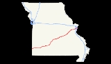
Interstate 44 in Missouri
Encyclopedia
In the U.S. state
of Missouri
, Interstate 44
runs northeast from the Oklahoma
state line near Joplin
to Interstate 55
in downtown St. Louis
. It runs for a total of 290 miles (467 km) in Missouri.
, 200 yards south of the Kansas
state line. The first interchange in Missouri is the eastern terminus of both U.S. Route 166 and U.S. Route 400. The road then runs through southern Joplin and begins a concurrency
with US 71 at Exit 11 just after entering Jasper County
. The freeway turns to a more eastern heading (the old US 166 alignment), and then US 71 splits off to the north at Exit 18.
I-44 then enters Lawrence County. Near Mount Vernon
, the highway curves to the northeast. The section of road to Halltown
is a completely new road, not bypassing any previous highways. At Halltown, the road curves back to due east, beginning to follow the general pathway of old U.S. Route 66 (which it will do all the way to downtown St. Louis). The highway then runs around the western and northern sides of Springfield
, serving as the western terminus of the James River Freeway
, as well as crossing both Route 13 and US 65. The interstate continues northeast, bypassing Lebanon
.
In Pulaski County
, I-44 enters the Mark Twain National Forest
, leaving it to provide access to Waynesville
, St. Robert
, and Fort Leonard Wood
before entering the forest again. The freeway leaves the forest in Phelps County
west of Rolla
. I-44 then runs through Rolla, where it meets US 63. It continues its northeast course, passing near St. James, Cuba
, Bourbon
, Sullivan
, and Saint Clair
.
I-44 then runs north of Pacific
before moving into St. Louis County
. I-44 then bisects Eureka
before serving as the southern boundary of Route 66 State Park
(the former site of Times Beach
, known for the dioxin contamination and subsequent demolition and Superfund
cleanup). I-44 then runs through unincorporated territory before entering Fenton
and having an interchange with Interstate 270 in Sunset Hills
. I-44 then runs through Crestwood
, Kirkwood, Oakland
, Webster Groves
, and Shrewsbury
before entering the city of St. Louis. I-44 runs on a due east course through St. Louis before ending at Interstate 55
in downtown just west of the Mississippi River
.
A section of I-44 was moved slightly north between Powellville
and Doolittle
. The old road is highly visible for eastbound traffic near Powellville. , the rocks carved away for the new roadbed have virtually no lichen
, reflecting that this construction occurred rather recently.
On Wednesday, October 5, 2011, a 2+1/2 mi stretch of I-44 in the city of St. Louis between Vandeventer and Mississippi avenues was named the David Haynes Memorial Highway, in honor of a St. Louis police officer who was killed in a car crash on March 24, 2010, at the age of 27, while chasing Sheldon Beckham, 24, a burglary suspect, who later pleaded guilty to second-degree murder, resisting arrest by fleeing the scene, stealing, and first-degree burglary and is scheduled to be sentenced at the end of October 2011.

 All of Interstate 44's business loops are in Missouri. Most of these Business Loops were the former U.S. Route 66. Missouri also has the unusual occurrence of a business loop and business spur from the same interstate intersecting (the Waynesville-St. Robert loop and the Ft. Leonard Wood spur).
U.S. state
A U.S. state is any one of the 50 federated states of the United States of America that share sovereignty with the federal government. Because of this shared sovereignty, an American is a citizen both of the federal entity and of his or her state of domicile. Four states use the official title of...
of Missouri
Missouri
Missouri is a US state located in the Midwestern United States, bordered by Iowa, Illinois, Kentucky, Tennessee, Arkansas, Oklahoma, Kansas and Nebraska. With a 2010 population of 5,988,927, Missouri is the 18th most populous state in the nation and the fifth most populous in the Midwest. It...
, Interstate 44
Interstate 44
Interstate 44 is a major highway in the central United States. Its western terminus is in Wichita Falls, Texas at a concurrency with US 277, US 281 and US 287; its eastern terminus is at the Illinois state line on the Poplar Street Bridge over the Mississippi River in St...
runs northeast from the Oklahoma
Oklahoma
Oklahoma is a state located in the South Central region of the United States of America. With an estimated 3,751,351 residents as of the 2010 census and a land area of 68,667 square miles , Oklahoma is the 28th most populous and 20th-largest state...
state line near Joplin
Joplin, Missouri
Joplin is a city in southern Jasper County and northern Newton County in the southwestern corner of the US state of Missouri. Joplin is the largest city in Jasper County, though it is not the county seat. As of the 2010 census, the city population was 50,150...
to Interstate 55
Interstate 55
Interstate 55 is an Interstate Highway in the central United States. Its odd number indicates that it is a north–south Interstate Highway. I-55 goes from LaPlace, Louisiana at Interstate 10 to Chicago at U.S. Route 41 , at McCormick Place. A common nickname for the highway is "double...
in downtown St. Louis
St. Louis, Missouri
St. Louis is an independent city on the eastern border of Missouri, United States. With a population of 319,294, it was the 58th-largest U.S. city at the 2010 U.S. Census. The Greater St...
. It runs for a total of 290 miles (467 km) in Missouri.
Route description
Interstate 44 enters Missouri in Newton County at the eastern terminus of the Will Rogers TurnpikeWill Rogers Turnpike
The Will Rogers Turnpike is a toll road in northeast Oklahoma that runs from Tulsa, Oklahoma to the Missouri state line. It is long and costs $4.00 to drive one way...
, 200 yards south of the Kansas
Kansas
Kansas is a US state located in the Midwestern United States. It is named after the Kansas River which flows through it, which in turn was named after the Kansa Native American tribe, which inhabited the area. The tribe's name is often said to mean "people of the wind" or "people of the south...
state line. The first interchange in Missouri is the eastern terminus of both U.S. Route 166 and U.S. Route 400. The road then runs through southern Joplin and begins a concurrency
Concurrency (road)
A concurrency, overlap, or coincidence in a road network is an instance of one physical road bearing two or more different highway, motorway, or other route numbers...
with US 71 at Exit 11 just after entering Jasper County
Jasper County, Missouri
Jasper County is a county located in the US state of Missouri. It is included in the Joplin, Missouri Metropolitan Statistical Area. The 2010 total population of Jasper County was 117,404. It is the ninth most populous county in Missouri. Its county seat is Carthage, making it one of the few...
. The freeway turns to a more eastern heading (the old US 166 alignment), and then US 71 splits off to the north at Exit 18.
I-44 then enters Lawrence County. Near Mount Vernon
Mount Vernon, Missouri
Mount Vernon is a city in Lawrence County, Missouri, United States. The population was 4,017 at the 2000 census. It is the county seat of Lawrence County. It is regionally known for its annual Apple butter Makin' Days festival in October. The high school's athletic teams are known as the...
, the highway curves to the northeast. The section of road to Halltown
Halltown, Missouri
Halltown is a village in Lawrence County, Missouri, United States. The population was 189 at the 2000 census.-Geography:Halltown is located at ....
is a completely new road, not bypassing any previous highways. At Halltown, the road curves back to due east, beginning to follow the general pathway of old U.S. Route 66 (which it will do all the way to downtown St. Louis). The highway then runs around the western and northern sides of Springfield
Springfield, Missouri
Springfield is the third largest city in the U.S. state of Missouri and the county seat of Greene County. According to the 2010 census data, the population was 159,498, an increase of 5.2% since the 2000 census. The Springfield Metropolitan Area, population 436,712, includes the counties of...
, serving as the western terminus of the James River Freeway
James River Freeway
James River Freeway is a fourteen mile -long freeway located largely on the south side of Springfield, Missouri. Its western terminus is at Interstate 44 north of Brookline and its eastern terminus is at U.S. Route 65 in southeastern Springfield. It is named for the James River, which passes near...
, as well as crossing both Route 13 and US 65. The interstate continues northeast, bypassing Lebanon
Lebanon, Missouri
Lebanon is a city in Laclede County, Missouri, United States. The estimated population in July 2009 was 14,292. The population was 12,155 at the 2000 census. It is the county seat of Laclede County. The Lebanon Micropolitan Statistical Area consists of Laclede County.-Geography:Lebanon is located at...
.
In Pulaski County
Pulaski County, Missouri
Pulaski County is a county located in the U.S. state of Missouri. The county was organized in 1833 and named for Kazimierz Pułaski, Polish patriot who died fighting in the American Revolution. As of 2010, the population was 52,274, an increase of 27% from the 2000 Census count of 41,165. Its...
, I-44 enters the Mark Twain National Forest
Mark Twain National Forest
Mark Twain National Forest is a U.S. National Forest located in the southern half of Missouri. MTNF was established on September 11, 1939. It is named for author Mark Twain, a Missouri native. The MTNF covers approximately 1.5 million acres , 78,000 acres of which are Wilderness, and National...
, leaving it to provide access to Waynesville
Waynesville, Missouri
-Registered historic places:* Old Stagecoach Stop * Pulaski County Courthouse-Transportation:Waynesville Regional Airport at Forney Field serves the community with air service; even though it's on Fort Leonard Wood, it is jointly run by the cities of Waynesville and St...
, St. Robert
St. Robert, Missouri
St. Robert is a city in Pulaski County, Missouri, United States. The population was 2,760 at the 2000 census. It is a gateway community to the United States Army Maneuver Support Center of Excellence Fort Leonard Wood. It is named after the local Catholic parish, whose patron saint was an...
, and Fort Leonard Wood
Fort Leonard Wood, Missouri
Fort Leonard Wood is a census-designated place in Pulaski County, Missouri, United States. The population was 13,667 at the 2000 census. It is named in honor of Major General Leonard Wood, who was awarded the Medal of Honor...
before entering the forest again. The freeway leaves the forest in Phelps County
Phelps County, Missouri
Phelps County is a county located in south-central Missouri in the United States.According to the U.S. Census Bureau, it includes the mean center of U.S. population in 2000. As of the 2000 U.S. Census, the county's population was 39,825. A 2008 estimate, however, showed the population to be 42,205....
west of Rolla
Rolla, Missouri
Rolla is a city in Phelps County, Missouri, United States, midway between the larger cities of St. Louis and Springfield along I-44. The population in the 2010 United States Census was 19,559.It is the county seat of Phelps County...
. I-44 then runs through Rolla, where it meets US 63. It continues its northeast course, passing near St. James, Cuba
Cuba, Missouri
Cuba is a city in Crawford County, Missouri, United States, and it is known as "Route 66 Mural City,"in recognition of Viva Cuba's . The population was 3,230 at the 2000 census.Cuba was once visited by Harry Truman during a tour of U.S. Route 66...
, Bourbon
Bourbon, Missouri
Bourbon is a city in Crawford County, Missouri, United States. The population was 1,348 at the 2000 census.-Geography:According to the United States Census Bureau, the city has a total area of , all of it land.-Demographics:...
, Sullivan
Sullivan, Missouri
Sullivan is a city that straddles the border of Franklin County and Crawford County in the U.S. state of Missouri. The population was 6,351 at the 2000 census. Stephen Sullivan founded the city in the late 1850s and cleared brush, which facilitated the building of the railway depot there, and the...
, and Saint Clair
Saint Clair, Missouri
Saint Clair is a city in Franklin County, Missouri, United States. The population was 4,472 at the 2010 census.-Geography:Saint Clair is located at ....
.
I-44 then runs north of Pacific
Pacific, Missouri
Pacific is a city in Franklin and St. Louis counties in the U.S. state of Missouri. The population was 7,002 at the 2010 census.-Geography:Pacific is located at . The city straddles the Franklin County/St. Louis County line, which lies halfway on the blocks between Elm and Neosho streets. St...
before moving into St. Louis County
St. Louis County, Missouri
St. Louis County is a county located in the U.S. state of Missouri. Its county seat is Clayton. St. Louis County is part of the St. Louis Metro Area wherein the independent City of St. Louis and its suburbs in St. Louis County, as well as the surrounding counties in both Missouri and Illinois all...
. I-44 then bisects Eureka
Eureka, Missouri
Eureka is a city located in St. Louis County, Missouri, United States, between St. Louis and Pacific, Missouri, along Interstate 44. As of the 2010 census, the city had a total population of 10,189. The city is west of the former site of Times Beach, the site of dioxin contamination discovered in...
before serving as the southern boundary of Route 66 State Park
Route 66 State Park
Route 66 State Park is a state park in the U.S. state of Missouri, located on the former site of the town of Times Beach. It is a 419 acre park located less than one mile east of Eureka....
(the former site of Times Beach
Times Beach, Missouri
Times Beach, Missouri was a small town of 2,240 residents in St. Louis County, Missouri, 17 miles southwest of St. Louis and 2 mi east of Eureka, Missouri. The town was completely evacuated early in 1983 due to a dioxin scare that made national headlines...
, known for the dioxin contamination and subsequent demolition and Superfund
Superfund
Superfund is the common name for the Comprehensive Environmental Response, Compensation, and Liability Act of 1980 , a United States federal law designed to clean up sites contaminated with hazardous substances...
cleanup). I-44 then runs through unincorporated territory before entering Fenton
Fenton, Missouri
Fenton is a city in St. Louis County, Missouri, United States, and a suburb of St. Louis. The population was 4,022 at the 2010 census.-History:Due to its proximity to fertile land and the Meramec River, the Fenton area has been inhabited for over 1,000 years...
and having an interchange with Interstate 270 in Sunset Hills
Sunset Hills, Missouri
Sunset Hills is a city in St. Louis County, Missouri, United States. The population was 8,496 at the 2010 census.-Geography:Sunset Hills is located at 38°32'8" North, 90°24'14" West ....
. I-44 then runs through Crestwood
Crestwood, Missouri
Crestwood is a city in St. Louis County, Missouri, United States, part of the Metropolitan Statistical Area known as Greater St. Louis. The population was 11,912 at the 2010 census.-Geography:Crestwood is located at ....
, Kirkwood, Oakland
Oakland, Missouri
Oakland is a city in St. Louis County, Missouri, United States. The population was 1,381 at the 2010 census.-Geography:Oakland is located at ....
, Webster Groves
Webster Groves, Missouri
Webster Groves is an inner-ring suburb of St. Louis, located in St. Louis County, Missouri, United States. The population was 22,995 at the 2010 census. The city is named after New England politician Daniel Webster....
, and Shrewsbury
Shrewsbury, Missouri
Shrewsbury is an inner-ring suburb of St. Louis, located in St. Louis County, Missouri. The population was 6,254 at the 2010 census.The city is home to the broadcast towers of KSDK- and KDNL-TV.-Geography:Shrewsbury is located at ....
before entering the city of St. Louis. I-44 runs on a due east course through St. Louis before ending at Interstate 55
Interstate 55
Interstate 55 is an Interstate Highway in the central United States. Its odd number indicates that it is a north–south Interstate Highway. I-55 goes from LaPlace, Louisiana at Interstate 10 to Chicago at U.S. Route 41 , at McCormick Place. A common nickname for the highway is "double...
in downtown just west of the Mississippi River
Mississippi River
The Mississippi River is the largest river system in North America. Flowing entirely in the United States, this river rises in western Minnesota and meanders slowly southwards for to the Mississippi River Delta at the Gulf of Mexico. With its many tributaries, the Mississippi's watershed drains...
.
History
I-44 follows the general route of, and completely replaced, historic U.S. Route 66 across Missouri.A section of I-44 was moved slightly north between Powellville
Powellville, Missouri
Powellville is a former town on U.S. Highway 66, now an outer road of Interstate 44 in Phelps County, Missouri, United States. It is located about twelve miles west of Rolla. Nothing remains of the town....
and Doolittle
Doolittle, Missouri
Doolittle is a city in Phelps County, Missouri, United States. The population was 644 at the 2000 census.-Geography:Doolittle is located at .According to the United States Census Bureau, the city has a total area of , all of it land.-Demographics:...
. The old road is highly visible for eastbound traffic near Powellville. , the rocks carved away for the new roadbed have virtually no lichen
Lichen
Lichens are composite organisms consisting of a symbiotic organism composed of a fungus with a photosynthetic partner , usually either a green alga or cyanobacterium...
, reflecting that this construction occurred rather recently.
On Wednesday, October 5, 2011, a 2+1/2 mi stretch of I-44 in the city of St. Louis between Vandeventer and Mississippi avenues was named the David Haynes Memorial Highway, in honor of a St. Louis police officer who was killed in a car crash on March 24, 2010, at the age of 27, while chasing Sheldon Beckham, 24, a burglary suspect, who later pleaded guilty to second-degree murder, resisting arrest by fleeing the scene, stealing, and first-degree burglary and is scheduled to be sentenced at the end of October 2011.
Future
The eastern terminus of I-44 is slated to be changed when the new I-70 Mississippi River Bridge is opened, rerouting I-70 over the river along a more northern alignment. I-44 is planned to take over the old I-70 alignment through the below-grade section of roadway in St. Louis, making the new eastern terminus being the interchange with I-70 near Cass Street.Business loops
Exit list
| County | Location | Mile | # Exit number An exit number is a number assigned to a road junction, usually an exit from a freeway. It is usually marked on the same sign as the destinations of the exit, as well as a sign in the gore.... |
Destinations | Notes |
|---|---|---|---|---|---|
| Newton | 1 | – Galena Galena, Kansas Galena is a city in Cherokee County, Kansas, United States. As of the 2010 census, the city population was 3,085.-History:The city was named after the lead ore galena found here in 1877. The city was originally platted by the Galena Mining and Smelting Company and was to be known as Cornwall... , Baxter Springs Baxter Springs, Kansas Baxter Springs is a town situated along the Spring River in the extreme southeastern part of Cherokee County, located in southeast Kansas, in the Central United States. As of the 2010 census, the city population was 4,238... |
Westbound exit and eastbound entrance | ||
| 4 | West end of Route 43 overlap | ||||
| Joplin Joplin, Missouri Joplin is a city in southern Jasper County and northern Newton County in the southwestern corner of the US state of Missouri. Joplin is the largest city in Jasper County, though it is not the county seat. As of the 2010 census, the city population was 50,150... |
6 | East end of Route 43 overlap | |||
| 8 | Signed as exits 8A (south) and 8B (north) | ||||
| Jasper Jasper County, Missouri Jasper County is a county located in the US state of Missouri. It is included in the Joplin, Missouri Metropolitan Statistical Area. The 2010 total population of Jasper County was 117,404. It is the ninth most populous county in Missouri. Its county seat is Carthage, making it one of the few... |
11A | , Fort Smith Fort Smith, Arkansas Fort Smith is the second-largest city in Arkansas and one of the two county seats of Sebastian County. With a population of 86,209 in 2010, it is the principal city of the Fort Smith, Arkansas-Oklahoma Metropolitan Statistical Area, a region of 298,592 residents which encompasses the Arkansas... |
West end of US 71 overlap | ||
| 11B | |||||
| 15 | Westbound exit and eastbound entrance | ||||
| Fidelity Fidelity, Missouri Fidelity is a village in Jasper County, Missouri, in the United States. The population was 257 at the 2010 census, at which time it was a town. It is part of the Joplin, Missouri Metropolitan Statistical Area.-Geography:... |
18A | ||||
| 18B | East end of US 71 overlap | ||||
| 22 | County Road No. 100 | ||||
| 26 | |||||
| 29 | |||||
| Lawrence | 33 | County Road No. 1010 | |||
| 38 | Eastbound exit to Route 97 south is via exit 33 | ||||
| 44 | |||||
| Mount Vernon Mount Vernon, Missouri Mount Vernon is a city in Lawrence County, Missouri, United States. The population was 4,017 at the 2000 census. It is the county seat of Lawrence County. It is regionally known for its annual Apple butter Makin' Days festival in October. The high school's athletic teams are known as the... |
46 | ||||
| 49 | |||||
| 57 | Westbound exit and eastbound entrance; Former US-66 U.S. Route 66 in Missouri U.S. Route 66 in Missouri ran from downtown St. Louis at the Mississippi River to the Kansas state line west of Joplin. The highway was originally Route 14 from St. Louis to Joplin and Route 1F from Joplin to Kansas. It underwent two major realignments and several lesser realignments in the... west |
||||
| 58 | |||||
| 61 | |||||
| Greene Greene County, Missouri Greene County is a county located in Southwest Missouri. As of 2010, the population was 275,174 making it the fourth most populated county in Missouri. Its county seat is Springfield... |
67 | ||||
| 69 | |||||
| 70 | |||||
| 72 | Former US-66 U.S. Route 66 in Missouri U.S. Route 66 in Missouri ran from downtown St. Louis at the Mississippi River to the Kansas state line west of Joplin. The highway was originally Route 14 from St. Louis to Joplin and Route 1F from Joplin to Kansas. It underwent two major realignments and several lesser realignments in the... |
||||
| Springfield Springfield, Missouri Springfield is the third largest city in the U.S. state of Missouri and the county seat of Greene County. According to the 2010 census data, the population was 159,498, an increase of 5.2% since the 2000 census. The Springfield Metropolitan Area, population 436,712, includes the counties of... |
75 | ||||
| 77 | First diverging diamond in North America | ||||
| 80A | |||||
| 80B | |||||
| 82 | Signed as exits 82A (south) and 82B (north) | ||||
| 84 | |||||
| Strafford Strafford, Missouri Strafford is a city in eastern Greene County, Missouri, United States. The population is 2,211 at the 2009 census, a small 2% of the population is African American and only .5% is Hispanic. It is part of the Springfield, Missouri Metropolitan Statistical Area... |
88 | ||||
| Webster Webster County, Missouri Webster County is a county located in Southwest Missouri. As of 2000, the population was 31,045. The population in 2010 was 36,202. Its county seat is Marshfield. The county was organized in 1855 and named for U.S. Senator and U.S... |
96 | ||||
| Marshfield Marshfield, Missouri Marshfield is a city in Webster County, Missouri, United States. The population was 6,633 at the 2010 census. It is the county seat and part of the Springfield, Missouri Metropolitan Statistical Area.- History :... |
100 | ||||
| 107 | Sampson Road, Sparkle Brook Road | ||||
| Laclede Laclede County, Missouri Laclede County is a county located in the U.S. state of Missouri. As of 2000, the population was 32,513. Its county seat is Lebanon. The county was organized February 24, 1849, and was named after Pierre Laclède, founder of St... |
Conway Conway, Missouri Conway is a city in Laclede County, Missouri, United States. The population was 743 at the 2000 census. It is southwest of Lebanon.-Geography:Conway is located at .... |
113 | |||
| Phillipsburg Phillipsburg, Missouri Phillipsburg is a village in Laclede County, Missouri, United States. The population was 201 at the 2000 census.-Geography:Phillipsburg is located at .... |
118 | Former US-66 U.S. Route 66 in Missouri U.S. Route 66 in Missouri ran from downtown St. Louis at the Mississippi River to the Kansas state line west of Joplin. The highway was originally Route 14 from St. Louis to Joplin and Route 1F from Joplin to Kansas. It underwent two major realignments and several lesser realignments in the... |
|||
| 123 | County Road | ||||
| Lebanon Lebanon, Missouri Lebanon is a city in Laclede County, Missouri, United States. The estimated population in July 2009 was 14,292. The population was 12,155 at the 2000 census. It is the county seat of Laclede County. The Lebanon Micropolitan Statistical Area consists of Laclede County.-Geography:Lebanon is located at... |
127 | Former US-66 U.S. Route 66 in Missouri U.S. Route 66 in Missouri ran from downtown St. Louis at the Mississippi River to the Kansas state line west of Joplin. The highway was originally Route 14 from St. Louis to Joplin and Route 1F from Joplin to Kansas. It underwent two major realignments and several lesser realignments in the... |
|||
| 129 | |||||
| 130 | |||||
| 135 | Former US-66 U.S. Route 66 in Missouri U.S. Route 66 in Missouri ran from downtown St. Louis at the Mississippi River to the Kansas state line west of Joplin. The highway was originally Route 14 from St. Louis to Joplin and Route 1F from Joplin to Kansas. It underwent two major realignments and several lesser realignments in the... |
||||
| 140 | |||||
| Pulaski Pulaski County, Missouri Pulaski County is a county located in the U.S. state of Missouri. The county was organized in 1833 and named for Kazimierz Pułaski, Polish patriot who died fighting in the American Revolution. As of 2010, the population was 52,274, an increase of 27% from the 2000 Census count of 41,165. Its... |
145 | ||||
| 150 | |||||
| 153 | |||||
| Waynesville Waynesville, Missouri -Registered historic places:* Old Stagecoach Stop * Pulaski County Courthouse-Transportation:Waynesville Regional Airport at Forney Field serves the community with air service; even though it's on Fort Leonard Wood, it is jointly run by the cities of Waynesville and St... |
156 | , Fort Leonard Wood Fort Leonard Wood, Missouri Fort Leonard Wood is a census-designated place in Pulaski County, Missouri, United States. The population was 13,667 at the 2000 census. It is named in honor of Major General Leonard Wood, who was awarded the Medal of Honor... |
|||
| St. Robert St. Robert, Missouri St. Robert is a city in Pulaski County, Missouri, United States. The population was 2,760 at the 2000 census. It is a gateway community to the United States Army Maneuver Support Center of Excellence Fort Leonard Wood. It is named after the local Catholic parish, whose patron saint was an... |
159 | Former US-66 U.S. Route 66 in Missouri U.S. Route 66 in Missouri ran from downtown St. Louis at the Mississippi River to the Kansas state line west of Joplin. The highway was originally Route 14 from St. Louis to Joplin and Route 1F from Joplin to Kansas. It underwent two major realignments and several lesser realignments in the... |
|||
| 161 | , Fort Leonard Wood Fort Leonard Wood, Missouri Fort Leonard Wood is a census-designated place in Pulaski County, Missouri, United States. The population was 13,667 at the 2000 census. It is named in honor of Major General Leonard Wood, who was awarded the Medal of Honor... |
||||
| 163 | |||||
| 169 | |||||
| Phelps Phelps County, Missouri Phelps County is a county located in south-central Missouri in the United States.According to the U.S. Census Bureau, it includes the mean center of U.S. population in 2000. As of the 2000 U.S. Census, the county's population was 39,825. A 2008 estimate, however, showed the population to be 42,205.... |
172 | No westbound entrance | |||
| 176 | Sugar Tree Road | ||||
| Doolittle Doolittle, Missouri Doolittle is a city in Phelps County, Missouri, United States. The population was 644 at the 2000 census.-Geography:Doolittle is located at .According to the United States Census Bureau, the city has a total area of , all of it land.-Demographics:... |
179 | ||||
| Rolla Rolla, Missouri Rolla is a city in Phelps County, Missouri, United States, midway between the larger cities of St. Louis and Springfield along I-44. The population in the 2010 United States Census was 19,559.It is the county seat of Phelps County... |
184 | Former US-66 U.S. Route 66 in Missouri U.S. Route 66 in Missouri ran from downtown St. Louis at the Mississippi River to the Kansas state line west of Joplin. The highway was originally Route 14 from St. Louis to Joplin and Route 1F from Joplin to Kansas. It underwent two major realignments and several lesser realignments in the... east |
|||
| 185 | |||||
| 186 | Former US-66 U.S. Route 66 in Missouri U.S. Route 66 in Missouri ran from downtown St. Louis at the Mississippi River to the Kansas state line west of Joplin. The highway was originally Route 14 from St. Louis to Joplin and Route 1F from Joplin to Kansas. It underwent two major realignments and several lesser realignments in the... |
||||
| 189 | |||||
| St. James St. James, Missouri St. James is a city in Phelps County, Missouri, United States. The population was 3,704 at the 2000 census.-Geography:St. James is located at... |
195 | Former US-66 U.S. Route 66 in Missouri U.S. Route 66 in Missouri ran from downtown St. Louis at the Mississippi River to the Kansas state line west of Joplin. The highway was originally Route 14 from St. Louis to Joplin and Route 1F from Joplin to Kansas. It underwent two major realignments and several lesser realignments in the... |
|||
| Crawford Crawford County, Missouri -State:In the Missouri House of Representatives, most of Crawford County is included within the 150th Legislative District and is currently represented by State Representative Jason T. Smith . In 2008, Smith defeated Democratic challenger James D. Ellis 69.97-30.03 percent; the Crawford County... |
203 | ||||
| Cuba Cuba, Missouri Cuba is a city in Crawford County, Missouri, United States, and it is known as "Route 66 Mural City,"in recognition of Viva Cuba's . The population was 3,230 at the 2000 census.Cuba was once visited by Harry Truman during a tour of U.S. Route 66... |
208 | ||||
| 210 | |||||
| 214 | |||||
| Bourbon Bourbon, Missouri Bourbon is a city in Crawford County, Missouri, United States. The population was 1,348 at the 2000 census.-Geography:According to the United States Census Bureau, the city has a total area of , all of it land.-Demographics:... |
218 | ||||
| Franklin Franklin County, Missouri Franklin County is a county located in the U.S. state of Missouri on the south side of the Missouri River. Franklin County is part of the St. Louis Metro Area and contains many of the St. Louis exurbs. Census 2010 put the population at 101,492; making it the 10th most populous county in Missouri.... |
Sullivan Sullivan, Missouri Sullivan is a city that straddles the border of Franklin County and Crawford County in the U.S. state of Missouri. The population was 6,351 at the 2000 census. Stephen Sullivan founded the city in the late 1850s and cleared brush, which facilitated the building of the railway depot there, and the... |
225 | |||
| 226 | |||||
| 230 | |||||
| St. Clair | 239 | ||||
| 240 | |||||
| 242 | |||||
| 247 | West end of US 50 overlap | ||||
| 251 | Former US-66 U.S. Route 66 in Missouri U.S. Route 66 in Missouri ran from downtown St. Louis at the Mississippi River to the Kansas state line west of Joplin. The highway was originally Route 14 from St. Louis to Joplin and Route 1F from Joplin to Kansas. It underwent two major realignments and several lesser realignments in the... |
||||
| 253 | Former US-66 U.S. Route 66 in Missouri U.S. Route 66 in Missouri ran from downtown St. Louis at the Mississippi River to the Kansas state line west of Joplin. The highway was originally Route 14 from St. Louis to Joplin and Route 1F from Joplin to Kansas. It underwent two major realignments and several lesser realignments in the... |
||||
| Pacific Pacific, Missouri Pacific is a city in Franklin and St. Louis counties in the U.S. state of Missouri. The population was 7,002 at the 2010 census.-Geography:Pacific is located at . The city straddles the Franklin County/St. Louis County line, which lies halfway on the blocks between Elm and Neosho streets. St... |
257 | ||||
| St. Louis St. Louis County, Missouri St. Louis County is a county located in the U.S. state of Missouri. Its county seat is Clayton. St. Louis County is part of the St. Louis Metro Area wherein the independent City of St. Louis and its suburbs in St. Louis County, as well as the surrounding counties in both Missouri and Illinois all... |
Eureka Eureka, Missouri Eureka is a city located in St. Louis County, Missouri, United States, between St. Louis and Pacific, Missouri, along Interstate 44. As of the 2010 census, the city had a total population of 10,189. The city is west of the former site of Times Beach, the site of dioxin contamination discovered in... |
261 | |||
| 264 | |||||
| 265 | Williams Road | Eastbound exit and entrance | |||
| 266 | Lewis Road | ||||
| 269 | Beaumont Antire Road | ||||
| 272 | |||||
| Fenton Fenton, Missouri Fenton is a city in St. Louis County, Missouri, United States, and a suburb of St. Louis. The population was 4,022 at the 2010 census.-History:Due to its proximity to fertile land and the Meramec River, the Fenton area has been inhabited for over 1,000 years... |
274A | Bowles Avenue | Signed as exit 274 westbound | ||
| 274B | Mraz Lane | Eastbound exit and westbound entrance | |||
| 275 | North Highway Drive, Soccer Park Road | Westbound exit and eastbound entrance | |||
| Sunset Hills Sunset Hills, Missouri Sunset Hills is a city in St. Louis County, Missouri, United States. The population was 8,496 at the 2010 census.-Geography:Sunset Hills is located at 38°32'8" North, 90°24'14" West .... |
276 | – Memphis Memphis, Tennessee Memphis is a city in the southwestern corner of the U.S. state of Tennessee, and the county seat of Shelby County. The city is located on the 4th Chickasaw Bluff, south of the confluence of the Wolf and Mississippi rivers.... , Chicago |
|||
| 277A | Eastbound exit and westbound entrance | ||||
| 277B | East end of US 50 overlap | ||||
| Kirkwood Kirkwood, Missouri Kirkwood is an inner-ring suburb of St. Louis, located in St. Louis County, Missouri. As of the 2010 census, the city population was 27,540. Founded in 1853, the city is named for James Pugh Kirkwood, builder of the Pacific Railroad through that town. It was the first planned suburb located west... |
|||||
| 278 | Big Bend Road | ||||
| Crestwood Crestwood, Missouri Crestwood is a city in St. Louis County, Missouri, United States, part of the Metropolitan Statistical Area known as Greater St. Louis. The population was 11,912 at the 2010 census.-Geography:Crestwood is located at .... |
|||||
| Webster Groves Webster Groves, Missouri Webster Groves is an inner-ring suburb of St. Louis, located in St. Louis County, Missouri, United States. The population was 22,995 at the 2010 census. The city is named after New England politician Daniel Webster.... |
279 | Berry Road | Westbound exit and eastbound entrance | ||
| 280 | Elm Avenue | ||||
| 282 | Murdoch Avenue, Laclede Station Road | Eastbound exit and westbound entrance | |||
| Shrewsbury Shrewsbury, Missouri Shrewsbury is an inner-ring suburb of St. Louis, located in St. Louis County, Missouri. The population was 6,254 at the 2010 census.The city is home to the broadcast towers of KSDK- and KDNL-TV.-Geography:Shrewsbury is located at .... |
283 | Shrewsbury Avenue | Westbound exit and eastbound entrance | ||
| City of St. Louis St. Louis, Missouri St. Louis is an independent city on the eastern border of Missouri, United States. With a population of 319,294, it was the 58th-largest U.S. city at the 2010 U.S. Census. The Greater St... |
284A | Jamieson Avenue | Eastbound exit and westbound entrance | ||
| 284B | Arsenal Street | Westbound exit and eastbound entrance | |||
| 285 | Southwest Avenue | Westbound exit and eastbound entrance | |||
| 286 | Hampton Avenue | ||||
| 287A | Kingshighway Boulevard | ||||
| 287B | Vandeventer Avenue | ||||
| 288 | Grand Boulevard, Louisiana Avenue | ||||
| 289 | Jefferson Avenue | ||||
| 290A | – Memphis Memphis, Tennessee Memphis is a city in the southwestern corner of the U.S. state of Tennessee, and the county seat of Shelby County. The city is located on the 4th Chickasaw Bluff, south of the confluence of the Wolf and Mississippi rivers.... |
Eastbound exit and westbound entrance | |||
| 290B | 18th Street | Eastbound exit and westbound entrance; former Route 755 | |||
| 290C | 12th Street, Gravois Avenue (Route 30) | Westbound exit and eastbound entrance | |||
| , Chicago | Eastbound exit and westbound entrance | ||||