

U.S. Route 66 in Missouri
Encyclopedia
U.S. Route 66
in Missouri
ran from downtown St. Louis
at the Mississippi River
to the Kansas
state line west of Joplin
. The highway was originally Route 14 from St. Louis to Joplin and Route 1F from Joplin to Kansas. It underwent two major realignments (in the St. Louis and Joplin areas) and several lesser realignments in the cities of St. Louis, Springfield
, and Joplin. Current highways covering several miles of the former highway include Route 100, Route 366, Route 266, Route 96, and Route 66. Interstate 44 approximates much of US 66 between St. Louis and Springfield.
Missouri was the first state to erect a historic marker on US 66. It is located at Kearney Street and Glenstone Avenue in northeast Springfield. A new marker, designating the highway as a National Scenic Byway
, was erected May 5, 2006. The historic alignment in Missouri is marked based on the route in 1935.
in St. Louis and continued west on Salisbury Street, turned south on Florissant Street, then west on Manchester Road (Route 100). It joined the later alignment at Gray Summit
.
The first major re-alignment of US 66 involved the construction of Watson Road (now Route 366). The road was realigned down Chippewa Street and Watson Road. Interstate 44 was built down Watson Road for several miles west of Sunset Hills
. With this realignment, US 66 crossed the Mississippi on MacArthur Bridge
. The older highway passes through downtown Pacific
in a scenic area under steep bluffs.
Bypass US 66 was routed over the Mississippi on the north side of St. Louis via the Chain of Rocks Bridge
. This alignment is now an outer road
of Interstate 270
from the river to Lindbergh Boulevard (U.S. Route 61/U.S. Route 67), then south on Lindbergh to Watson Road. At other times, US 66 crossed the Mississippi on the Martin Luther King Bridge
, and on the Poplar Street Bridge
.
 The highway passes near Meramec Caverns
in Stanton
, formerly a famous stop. Between Sullivan
and St. James
is a major grape
growing area and many wineries
.
Cuba
, known as Route 66 Mural City has 12 outdoor murals and other art and sculpture throughout the town and along the Route 66 corridor. Its restaurants are often a "must stop" for Rt. 66 travelers. The Crawford County History Museum has a Route 66 exhibit.
At Rolla
, about halfway to Springfield, US 66 intersects U.S. Route 63 and passes the Missouri University of Science and Technology
. The university's half-scale model of Stonehenge
is located next to the highway. At Rolla, US 66 entered the Ozark Mountains. At Philipsburg
, Interstate 44 was built some distance away from former US 66 and passed through Marshfield
, birthplace of astronomer Edwin Hubble
.
with U.S. Route 65 for several miles, and also served as the original western terminus of U.S. Route 60. US 60 no longer intersects US 66 in Missouri at all. Bypass US 66 followed Kearney Street on the north side of Springfield to West Bypass. Later, this would become the main alignment of US 66.
Springfield boasted the only double-bannered highway: Alternate Business US 66.
Among the Route 66 sites in Springfield are the Abou Ben Adhem Shrine Mosque
and the site of Red's Giant Hamburgs
, the world's first drive-thru restaurant.
, away from US 66. The reason for this was the already completed Will Rogers Turnpike
in Oklahoma
, which Oklahoma wished to become part of Interstate 44. In order to complete the hookup, I-44 took over for U.S. Route 166 from Mount Vernon
to the Oklahoma state line southwest of Joplin. At Carthage
, Historic US 66 winds through various county roads and the city streets of Carterville
and Webb City
. In Carthage, US 66 once ran concurrently with U.S. Route 71.
s built under the highway. It zig-zagged through the city, following Rangeline Road, Zora Street, Florida Avenue, Utica Street, Euclid Avenue, St. Louis Avenue, Broadway, Main Avenue, and Seventh Street, the last now State Route 66. An old segment of highway (named Route 66 Boulevard), splits off from modern Route 66 and enters Kansas to the north of the current highway.
Later, US Route 66 went straight south on Rangeline to Seventh and then west to the Kansas state line.
was completed in 1979, US 66 was truncated to east of Duenweg
. Seventh Street, east of Duenweg, had been US 166, then now US 66 which continued straight through Duenweg, Duquesne
, and Joplin to the Kansas state line.
and Joplin
. In 1926, it was designated a national highway, US 66.
The route between St. Louis and Springfield
is an old road. It had traditionally been a Native American trail, known as the "Osage Indian Trail". By the early-to-mid-19th century, settlers laid a telegraph line along the road (it continued south from Springfield to Fort Smith, Arkansas
). It then was called the "Wire Road", and later the "Old Wire Road
" after the telegraph line came down.
The highway subsequently became part of the Ozark Trail
.
U.S. Route 66
U.S. Route 66 was a highway within the U.S. Highway System. One of the original U.S. highways, Route 66 was established on November 11, 1926 -- with road signs erected the following year...
in Missouri
Missouri
Missouri is a US state located in the Midwestern United States, bordered by Iowa, Illinois, Kentucky, Tennessee, Arkansas, Oklahoma, Kansas and Nebraska. With a 2010 population of 5,988,927, Missouri is the 18th most populous state in the nation and the fifth most populous in the Midwest. It...
ran from downtown St. Louis
St. Louis, Missouri
St. Louis is an independent city on the eastern border of Missouri, United States. With a population of 319,294, it was the 58th-largest U.S. city at the 2010 U.S. Census. The Greater St...
at the Mississippi River
Mississippi River
The Mississippi River is the largest river system in North America. Flowing entirely in the United States, this river rises in western Minnesota and meanders slowly southwards for to the Mississippi River Delta at the Gulf of Mexico. With its many tributaries, the Mississippi's watershed drains...
to the Kansas
Kansas
Kansas is a US state located in the Midwestern United States. It is named after the Kansas River which flows through it, which in turn was named after the Kansa Native American tribe, which inhabited the area. The tribe's name is often said to mean "people of the wind" or "people of the south...
state line west of Joplin
Joplin, Missouri
Joplin is a city in southern Jasper County and northern Newton County in the southwestern corner of the US state of Missouri. Joplin is the largest city in Jasper County, though it is not the county seat. As of the 2010 census, the city population was 50,150...
. The highway was originally Route 14 from St. Louis to Joplin and Route 1F from Joplin to Kansas. It underwent two major realignments (in the St. Louis and Joplin areas) and several lesser realignments in the cities of St. Louis, Springfield
Springfield, Missouri
Springfield is the third largest city in the U.S. state of Missouri and the county seat of Greene County. According to the 2010 census data, the population was 159,498, an increase of 5.2% since the 2000 census. The Springfield Metropolitan Area, population 436,712, includes the counties of...
, and Joplin. Current highways covering several miles of the former highway include Route 100, Route 366, Route 266, Route 96, and Route 66. Interstate 44 approximates much of US 66 between St. Louis and Springfield.
Missouri was the first state to erect a historic marker on US 66. It is located at Kearney Street and Glenstone Avenue in northeast Springfield. A new marker, designating the highway as a National Scenic Byway
National Scenic Byway
A National Scenic Byway is a road recognized by the United States Department of Transportation for its archeological, cultural, historic, natural, recreational, and/or scenic qualities. The program was established by Congress in 1991 to preserve and protect the nation's scenic but often...
, was erected May 5, 2006. The historic alignment in Missouri is marked based on the route in 1935.
US 66 in the St. Louis area
The original route through St. Louis entered Missouri on the McKinley BridgeMcKinley Bridge
The McKinley Bridge is a steel truss bridge across the Mississippi River. It connects northern portions of the city of St. Louis, Missouri with Venice, Illinois. It opened in 1910 and was taken out of service on October 30, 2001. The bridge was reopened for pedestrian and bicyclists on November 17,...
in St. Louis and continued west on Salisbury Street, turned south on Florissant Street, then west on Manchester Road (Route 100). It joined the later alignment at Gray Summit
Gray Summit, Missouri
Gray Summit is a census-designated place in Franklin County, Missouri, United States. The population was 2,640 at the 2000 census. Also called Gray's Summit, it was founded by Daniel Gray of New York who built a hotel here in 1845. This community was the highest point on the Missouri Pacific...
.
The first major re-alignment of US 66 involved the construction of Watson Road (now Route 366). The road was realigned down Chippewa Street and Watson Road. Interstate 44 was built down Watson Road for several miles west of Sunset Hills
Sunset Hills, Missouri
Sunset Hills is a city in St. Louis County, Missouri, United States. The population was 8,496 at the 2010 census.-Geography:Sunset Hills is located at 38°32'8" North, 90°24'14" West ....
. With this realignment, US 66 crossed the Mississippi on MacArthur Bridge
MacArthur Bridge (St. Louis)
The MacArthur Bridge over the Mississippi River between St. Louis, Missouri and East St. Louis, Illinois is a 647 foot long truss bridge. Construction on the bridge was begun in 1909 by the city of St. Louis to break the Terminal Railroad Association of St. Louis's monopoly on the area's railroad...
. The older highway passes through downtown Pacific
Pacific, Missouri
Pacific is a city in Franklin and St. Louis counties in the U.S. state of Missouri. The population was 7,002 at the 2010 census.-Geography:Pacific is located at . The city straddles the Franklin County/St. Louis County line, which lies halfway on the blocks between Elm and Neosho streets. St...
in a scenic area under steep bluffs.
Bypass US 66 was routed over the Mississippi on the north side of St. Louis via the Chain of Rocks Bridge
Chain of Rocks Bridge
The Chain of Rocks Bridge spans the Mississippi River on the north edge of St. Louis, Missouri. The eastern end of the bridge is on Chouteau Island, , while the western end is on the Missouri shoreline....
. This alignment is now an outer road
Frontage road
A frontage road is a non-limited access road running parallel to a higher-speed road, usually a freeway, and feeding it at appropriate points of access...
of Interstate 270
Interstate 270 (Illinois-Missouri)
Interstate 270 makes up a large portion of the outer belt freeway in the St. Louis, Missouri metropolitan area. The counterclockwise terminus of I-270 is at the junction with Interstate 55 in Mehlville, Missouri; the clockwise terminus of the freeway is at the junction with I-55 and I-70 north of...
from the river to Lindbergh Boulevard (U.S. Route 61/U.S. Route 67), then south on Lindbergh to Watson Road. At other times, US 66 crossed the Mississippi on the Martin Luther King Bridge
Martin Luther King Bridge (St. Louis)
The Martin Luther King Bridge in St. Louis is a cantilever truss bridge of about in total length across the Mississippi River, connecting St. Louis with East St. Louis, Illinois. The bridge serves as traffic relief connecting the concurrent freeways of Interstate 55, Interstate 70, Interstate...
, and on the Poplar Street Bridge
Poplar Street Bridge
The Poplar Street Bridge, officially the Bernard F. Dickmann Bridge, completed in 1967, is a long deck girder bridge across the Mississippi River between St. Louis, Missouri and East St. Louis, Illinois...
.
US 66 from St. Louis to Springfield
Meramec Caverns
Meramec Caverns is the collective name for a cavern system in the Ozarks, near Stanton, Missouri. The caverns were formed from the erosion of large limestone deposits over millions of years. Pre-Columbian Native American artifacts have been found in the caverns...
in Stanton
Stanton, Missouri
Stanton is an unincorporated community in Franklin County, Missouri, United States. It lies on Interstate 44 at the junction with Missouri Supplemental Route W. Prior to Interstate 44, it was an important town on U.S. Route 66 due to the nearby Meramec Caverns very prominently advertised up and...
, formerly a famous stop. Between Sullivan
Sullivan, Missouri
Sullivan is a city that straddles the border of Franklin County and Crawford County in the U.S. state of Missouri. The population was 6,351 at the 2000 census. Stephen Sullivan founded the city in the late 1850s and cleared brush, which facilitated the building of the railway depot there, and the...
and St. James
St. James, Missouri
St. James is a city in Phelps County, Missouri, United States. The population was 3,704 at the 2000 census.-Geography:St. James is located at...
is a major grape
Grape
A grape is a non-climacteric fruit, specifically a berry, that grows on the perennial and deciduous woody vines of the genus Vitis. Grapes can be eaten raw or they can be used for making jam, juice, jelly, vinegar, wine, grape seed extracts, raisins, molasses and grape seed oil. Grapes are also...
growing area and many wineries
Winery
A winery is a building or property that produces wine, or a business involved in the production of wine, such as a wine company. Some wine companies own many wineries. Besides wine making equipment, larger wineries may also feature warehouses, bottling lines, laboratories, and large expanses of...
.
Cuba
Cuba, Missouri
Cuba is a city in Crawford County, Missouri, United States, and it is known as "Route 66 Mural City,"in recognition of Viva Cuba's . The population was 3,230 at the 2000 census.Cuba was once visited by Harry Truman during a tour of U.S. Route 66...
, known as Route 66 Mural City has 12 outdoor murals and other art and sculpture throughout the town and along the Route 66 corridor. Its restaurants are often a "must stop" for Rt. 66 travelers. The Crawford County History Museum has a Route 66 exhibit.
At Rolla
Rolla, Missouri
Rolla is a city in Phelps County, Missouri, United States, midway between the larger cities of St. Louis and Springfield along I-44. The population in the 2010 United States Census was 19,559.It is the county seat of Phelps County...
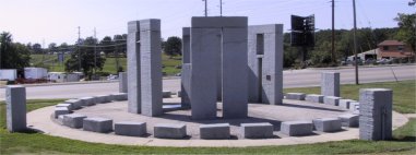
, about halfway to Springfield, US 66 intersects U.S. Route 63 and passes the Missouri University of Science and Technology
Missouri University of Science and Technology
Missouri University of Science and Technology is an institution of higher learning located in Rolla, Missouri, United States, and part of the University of Missouri System...
. The university's half-scale model of Stonehenge
Stonehenge
Stonehenge is a prehistoric monument located in the English county of Wiltshire, about west of Amesbury and north of Salisbury. One of the most famous sites in the world, Stonehenge is composed of a circular setting of large standing stones set within earthworks...
is located next to the highway. At Rolla, US 66 entered the Ozark Mountains. At Philipsburg
Phillipsburg, Missouri
Phillipsburg is a village in Laclede County, Missouri, United States. The population was 201 at the 2000 census.-Geography:Phillipsburg is located at ....
, Interstate 44 was built some distance away from former US 66 and passed through Marshfield
Marshfield, Missouri
Marshfield is a city in Webster County, Missouri, United States. The population was 6,633 at the 2010 census. It is the county seat and part of the Springfield, Missouri Metropolitan Statistical Area.- History :...
, birthplace of astronomer Edwin Hubble
Edwin Hubble
Edwin Powell Hubble was an American astronomer who profoundly changed the understanding of the universe by confirming the existence of galaxies other than the Milky Way - our own galaxy...
.
US 66 in Springfield
The alignment through Springfield includes Kearney Street, Glenstone Avenue, St. Louis Street, College Street, and Chestnut Expressway. At Springfield, US 66 was joinedConcurrency (road)
A concurrency, overlap, or coincidence in a road network is an instance of one physical road bearing two or more different highway, motorway, or other route numbers...
with U.S. Route 65 for several miles, and also served as the original western terminus of U.S. Route 60. US 60 no longer intersects US 66 in Missouri at all. Bypass US 66 followed Kearney Street on the north side of Springfield to West Bypass. Later, this would become the main alignment of US 66.
Springfield boasted the only double-bannered highway: Alternate Business US 66.
Among the Route 66 sites in Springfield are the Abou Ben Adhem Shrine Mosque
Abou Ben Adhem Shrine Mosque
The Abou Ben Adhem Shrine Mosque is a building of arabesque design located in downtown Springfield, Missouri, USA. It is owned by the Ancient Arabic Order of the Nobles of the Mystic Shrine , and is the site of the annual Shrine Circus...
and the site of Red's Giant Hamburgs
Red's Giant Hamburgs
Red's Giant Hamburg was a cafe on U.S. Highway 66 in Springfield, Missouri which claimed to have been the world's first drive-through restaurant....
, the world's first drive-thru restaurant.
US 66 from Springfield to Joplin
West of Springfield, US 66 followed Route 266 and Route 96. Interstate 44 turned southwest at HalltownHalltown, Missouri
Halltown is a village in Lawrence County, Missouri, United States. The population was 189 at the 2000 census.-Geography:Halltown is located at ....
, away from US 66. The reason for this was the already completed Will Rogers Turnpike
Will Rogers Turnpike
The Will Rogers Turnpike is a toll road in northeast Oklahoma that runs from Tulsa, Oklahoma to the Missouri state line. It is long and costs $4.00 to drive one way...
in Oklahoma
Oklahoma
Oklahoma is a state located in the South Central region of the United States of America. With an estimated 3,751,351 residents as of the 2010 census and a land area of 68,667 square miles , Oklahoma is the 28th most populous and 20th-largest state...
, which Oklahoma wished to become part of Interstate 44. In order to complete the hookup, I-44 took over for U.S. Route 166 from Mount Vernon
Mount Vernon, Missouri
Mount Vernon is a city in Lawrence County, Missouri, United States. The population was 4,017 at the 2000 census. It is the county seat of Lawrence County. It is regionally known for its annual Apple butter Makin' Days festival in October. The high school's athletic teams are known as the...
to the Oklahoma state line southwest of Joplin. At Carthage
Carthage, Missouri
Carthage is a city in Jasper County, Missouri, United States. The population was 14,378 at the 2010 census. It is the county seat of Jasper County and is nicknamed "America's Maple Leaf City."...
, Historic US 66 winds through various county roads and the city streets of Carterville
Carterville, Missouri
Carterville is a city in Jasper County, Missouri, United States. The population was 1,891 at the 2010 census. It is part of the Joplin, Missouri Metropolitan Statistical Area.-Geography:...
and Webb City
Webb City, Missouri
Webb City is a city in Jasper County, Missouri, United States. The population was 10,996 at the 2010 census. It is part of the Joplin, Missouri Metropolitan Statistical Area.-Geography:Webb City is located at ....
. In Carthage, US 66 once ran concurrently with U.S. Route 71.
US 66 in Joplin
Due to the mining history of Joplin, the realignment of US 66 in Joplin was partially for traffic and partially because of cave-ins of mineMining
Mining is the extraction of valuable minerals or other geological materials from the earth, from an ore body, vein or seam. The term also includes the removal of soil. Materials recovered by mining include base metals, precious metals, iron, uranium, coal, diamonds, limestone, oil shale, rock...
s built under the highway. It zig-zagged through the city, following Rangeline Road, Zora Street, Florida Avenue, Utica Street, Euclid Avenue, St. Louis Avenue, Broadway, Main Avenue, and Seventh Street, the last now State Route 66. An old segment of highway (named Route 66 Boulevard), splits off from modern Route 66 and enters Kansas to the north of the current highway.
Later, US Route 66 went straight south on Rangeline to Seventh and then west to the Kansas state line.
Interstate 44 and US 66
With the completion of Interstate 44, US 66 was aligned down I-44 from St. Louis to Halltown, except for the St. Louis area itself, where it continued on Gravois Road (Route 30) and Chippewa Street/Watson Road (Route 366). At Halltown, US 66 continued down what would later be Route 96 to Joplin. When Interstate 55 in IllinoisIllinois
Illinois is the fifth-most populous state of the United States of America, and is often noted for being a microcosm of the entire country. With Chicago in the northeast, small industrial cities and great agricultural productivity in central and northern Illinois, and natural resources like coal,...
was completed in 1979, US 66 was truncated to east of Duenweg
Duenweg, Missouri
Duenweg is a city in Jasper County, Missouri, United States. The population was 1,121 at the 2010 census. It is part of the Joplin, Missouri Metropolitan Statistical Area.-Geography:Duenweg is located at ....
. Seventh Street, east of Duenweg, had been US 166, then now US 66 which continued straight through Duenweg, Duquesne
Duquesne, Missouri
Duquesne is a village in Jasper County, Missouri, United States. The population was 1,763 at the 2010 census. It is part of the Joplin, Missouri Metropolitan Statistical Area.-Geography:Duquesne is located at ....
, and Joplin to the Kansas state line.
History
In 1922, US 66 was originally Route 14, connecting St. LouisSt. Louis, Missouri
St. Louis is an independent city on the eastern border of Missouri, United States. With a population of 319,294, it was the 58th-largest U.S. city at the 2010 U.S. Census. The Greater St...
and Joplin
Joplin, Missouri
Joplin is a city in southern Jasper County and northern Newton County in the southwestern corner of the US state of Missouri. Joplin is the largest city in Jasper County, though it is not the county seat. As of the 2010 census, the city population was 50,150...
. In 1926, it was designated a national highway, US 66.
The route between St. Louis and Springfield
Springfield, Missouri
Springfield is the third largest city in the U.S. state of Missouri and the county seat of Greene County. According to the 2010 census data, the population was 159,498, an increase of 5.2% since the 2000 census. The Springfield Metropolitan Area, population 436,712, includes the counties of...
is an old road. It had traditionally been a Native American trail, known as the "Osage Indian Trail". By the early-to-mid-19th century, settlers laid a telegraph line along the road (it continued south from Springfield to Fort Smith, Arkansas
Fort Smith, Arkansas
Fort Smith is the second-largest city in Arkansas and one of the two county seats of Sebastian County. With a population of 86,209 in 2010, it is the principal city of the Fort Smith, Arkansas-Oklahoma Metropolitan Statistical Area, a region of 298,592 residents which encompasses the Arkansas...
). It then was called the "Wire Road", and later the "Old Wire Road
Old Wire Road
The Old Wire Road is a historic road in Missouri and Arkansas. Several local roads are still called this. It followed an old Native American route, the Great Osage Trail across the Ozarks and became a road along a telegraph line from St. Louis, Missouri to Fort Smith, Arkansas. This route was...
" after the telegraph line came down.
The highway subsequently became part of the Ozark Trail
Ozark Trail (auto trail)
The Ozark Trail was a network of locally maintained roads and highways organized by the Ozark Trails Association that predated the United States federal highway system. The roads ran from St. Louis, Missouri, to El Paso, Texas, and Santa Fe, New Mexico, over a series of routes. These roads were...
.