

Pacific, Missouri
Encyclopedia
Pacific is a city in Franklin
and St. Louis
counties in the U.S. state
of Missouri
. The population was 7,002 at the 2010 census.
/St. Louis County
line, which lies halfway on the blocks between Elm and Neosho streets. St. Louis
is 30 mile northeast of Pacific, and the communities comprising the Missouri Rhineland
are 20 mile northwest of the city.
Pacific is bordered on the southeast by the Pacific Palisades
Conservation area. Access to the Meramec River, through the Pacific Palisades conservation area, is located east of the city next to Eureka
on the north side. The majority of the Pacific Palisades area itself, south of the river, is accessed 1 miles (1.6 km) south of the city in Jefferson County.
 The Union Pacific (formerly Missouri Pacific) railroad, Burlington Northern
(formerly St. Louis San-Francisco) Railroad, historic Route 66
, Brush Creek, and Fox Creek run through the town.
According to the United States Census Bureau
, the city has a total area of 5.4 square miles (14 km²), of which 0.18% is water. 1.7 sq mi (4.4 km²) of the city is located in St. Louis County. The city is located directly west from Eureka and 5 miles (8 km) east of Gray Summit
.
The Red Cedar Inn, on the east end of town, was a meeting place for people around the country seeking out one of the oldest restaurants still standing on Route 66. The restaurant closed in 2007 and is now a business center. One of the businesses is a used auto sales business.
of 2000, there were 5,482 people, 2,166 households, and 1,431 families residing in the city. The population density
was 1,011.0 people per square mile (390.5/km²). There are 2,343 housing units at an average Value at $97,987.22 /km² (432.1/sq mi). The racial makeup of the city was 94.35% White, 2.92% African American, 0.38% Asian, 0.31% Native American, 0.04% Pacific Islander, 0.53% from other races
, and 1.48% from two or more races. Hispanic or Latino of any race were 1.08% of the population.
There were 2,166 households out of which 33.4% had children under the age of 18 living with them, 46.1% were married couples
living together, 15.1% had a female householder with no husband present, and 33.9% were non-families. 28.5% of all households were made up of individuals and 9.7% had someone living alone who was 65 years of age or older. The average household size was 2.48 and the average family size was 3.05.
In the city the population was spread out with 26.6% under the age of 18, 9.4% from 18 to 24, 31.9% from 25 to 44, 19.7% from 45 to 64, and 12.5% who were 65 years of age or older. The median age was 34 years. For every 100 females there were 94.6 males. For every 100 females age 18 and over, there were 88.4 males.
The median income for a household in the city was $39,554, and the median income for a family was $44,545. Males had a median income of $32,813 versus $22,529 for females. The per capita income
for the city was $17,865. About 8.8% of families and 14.7% of the population were below the poverty line, including 19.7% of those under age 18 and 19.4% of those age 65 or over.
district, and many residents attend nearby East Central community college
.
Elementary and secondary schools in the Meramec Valley R-III School District:
Schools not in the public school district:
Franklin County, Missouri
Franklin County is a county located in the U.S. state of Missouri on the south side of the Missouri River. Franklin County is part of the St. Louis Metro Area and contains many of the St. Louis exurbs. Census 2010 put the population at 101,492; making it the 10th most populous county in Missouri....
and St. Louis
St. Louis County, Missouri
St. Louis County is a county located in the U.S. state of Missouri. Its county seat is Clayton. St. Louis County is part of the St. Louis Metro Area wherein the independent City of St. Louis and its suburbs in St. Louis County, as well as the surrounding counties in both Missouri and Illinois all...
counties in the U.S. state
U.S. state
A U.S. state is any one of the 50 federated states of the United States of America that share sovereignty with the federal government. Because of this shared sovereignty, an American is a citizen both of the federal entity and of his or her state of domicile. Four states use the official title of...
of Missouri
Missouri
Missouri is a US state located in the Midwestern United States, bordered by Iowa, Illinois, Kentucky, Tennessee, Arkansas, Oklahoma, Kansas and Nebraska. With a 2010 population of 5,988,927, Missouri is the 18th most populous state in the nation and the fifth most populous in the Midwest. It...
. The population was 7,002 at the 2010 census.
Geography
Pacific is located at 38°28′53"N 90°45′0"W (38.481503, -90.750015). The city straddles the Franklin CountyFranklin County, Missouri
Franklin County is a county located in the U.S. state of Missouri on the south side of the Missouri River. Franklin County is part of the St. Louis Metro Area and contains many of the St. Louis exurbs. Census 2010 put the population at 101,492; making it the 10th most populous county in Missouri....
/St. Louis County
St. Louis County, Missouri
St. Louis County is a county located in the U.S. state of Missouri. Its county seat is Clayton. St. Louis County is part of the St. Louis Metro Area wherein the independent City of St. Louis and its suburbs in St. Louis County, as well as the surrounding counties in both Missouri and Illinois all...
line, which lies halfway on the blocks between Elm and Neosho streets. St. Louis
St. Louis, Missouri
St. Louis is an independent city on the eastern border of Missouri, United States. With a population of 319,294, it was the 58th-largest U.S. city at the 2010 U.S. Census. The Greater St...
is 30 mile northeast of Pacific, and the communities comprising the Missouri Rhineland
Missouri Rhineland
The Missouri Rhineland is a geographical area of Missouri that extends from west of St. Louis to slightly east of Jefferson City, located mostly in the Missouri River Valley on both sides of the river...
are 20 mile northwest of the city.
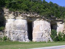
Pacific is bordered on the southeast by the Pacific Palisades
Pacific Palisades, Missouri
The Pacific Palisades is a conservation area located along the Meramec River where St. Louis, Jefferson, and Franklin counties meet in Missouri, USA. It is named for the rock and sand formations along this portion of the Meramec river....
Conservation area. Access to the Meramec River, through the Pacific Palisades conservation area, is located east of the city next to Eureka
Eureka, Missouri
Eureka is a city located in St. Louis County, Missouri, United States, between St. Louis and Pacific, Missouri, along Interstate 44. As of the 2010 census, the city had a total population of 10,189. The city is west of the former site of Times Beach, the site of dioxin contamination discovered in...
on the north side. The majority of the Pacific Palisades area itself, south of the river, is accessed 1 miles (1.6 km) south of the city in Jefferson County.
Burlington Northern Railroad
The Burlington Northern Railroad was a United States-based railroad company formed from a merger of four major U.S. railroads. Burlington Northern operated between 1970 and 1996....
(formerly St. Louis San-Francisco) Railroad, historic Route 66
U.S. Route 66
U.S. Route 66 was a highway within the U.S. Highway System. One of the original U.S. highways, Route 66 was established on November 11, 1926 -- with road signs erected the following year...
, Brush Creek, and Fox Creek run through the town.
According to the United States Census Bureau
United States Census Bureau
The United States Census Bureau is the government agency that is responsible for the United States Census. It also gathers other national demographic and economic data...
, the city has a total area of 5.4 square miles (14 km²), of which 0.18% is water. 1.7 sq mi (4.4 km²) of the city is located in St. Louis County. The city is located directly west from Eureka and 5 miles (8 km) east of Gray Summit
Gray Summit, Missouri
Gray Summit is a census-designated place in Franklin County, Missouri, United States. The population was 2,640 at the 2000 census. Also called Gray's Summit, it was founded by Daniel Gray of New York who built a hotel here in 1845. This community was the highest point on the Missouri Pacific...
.
Commercial areas
The Old Downtown Commerce Area is mostly located along First and St. Louis streets. The historic downtown buildings, built in the late 1800s, have been fully or partially restored, and new businesses have moved into the buildings.The Red Cedar Inn, on the east end of town, was a meeting place for people around the country seeking out one of the oldest restaurants still standing on Route 66. The restaurant closed in 2007 and is now a business center. One of the businesses is a used auto sales business.
Demographics
As of the censusCensus
A census is the procedure of systematically acquiring and recording information about the members of a given population. It is a regularly occurring and official count of a particular population. The term is used mostly in connection with national population and housing censuses; other common...
of 2000, there were 5,482 people, 2,166 households, and 1,431 families residing in the city. The population density
Population density
Population density is a measurement of population per unit area or unit volume. It is frequently applied to living organisms, and particularly to humans...
was 1,011.0 people per square mile (390.5/km²). There are 2,343 housing units at an average Value at $97,987.22 /km² (432.1/sq mi). The racial makeup of the city was 94.35% White, 2.92% African American, 0.38% Asian, 0.31% Native American, 0.04% Pacific Islander, 0.53% from other races
Race (United States Census)
Race and ethnicity in the United States Census, as defined by the Federal Office of Management and Budget and the United States Census Bureau, are self-identification data items in which residents choose the race or races with which they most closely identify, and indicate whether or not they are...
, and 1.48% from two or more races. Hispanic or Latino of any race were 1.08% of the population.
There were 2,166 households out of which 33.4% had children under the age of 18 living with them, 46.1% were married couples
Marriage
Marriage is a social union or legal contract between people that creates kinship. It is an institution in which interpersonal relationships, usually intimate and sexual, are acknowledged in a variety of ways, depending on the culture or subculture in which it is found...
living together, 15.1% had a female householder with no husband present, and 33.9% were non-families. 28.5% of all households were made up of individuals and 9.7% had someone living alone who was 65 years of age or older. The average household size was 2.48 and the average family size was 3.05.
In the city the population was spread out with 26.6% under the age of 18, 9.4% from 18 to 24, 31.9% from 25 to 44, 19.7% from 45 to 64, and 12.5% who were 65 years of age or older. The median age was 34 years. For every 100 females there were 94.6 males. For every 100 females age 18 and over, there were 88.4 males.
The median income for a household in the city was $39,554, and the median income for a family was $44,545. Males had a median income of $32,813 versus $22,529 for females. The per capita income
Per capita income
Per capita income or income per person is a measure of mean income within an economic aggregate, such as a country or city. It is calculated by taking a measure of all sources of income in the aggregate and dividing it by the total population...
for the city was $17,865. About 8.8% of families and 14.7% of the population were below the poverty line, including 19.7% of those under age 18 and 19.4% of those age 65 or over.
Schools and colleges
Pacific and its surrounding communities are served by the Meramec Valley R-III school system and the St. Louis Community CollegeSt. Louis Community College
St. Louis Community College is the Missouri two-year college supported by the Junior College District of St. Louis City – St. Louis County. The three original campuses were built simultaneously in 1964: Florissant Valley , Forest Park , and Meramec . A fourth campus, Wildwood opened in August 2007...
district, and many residents attend nearby East Central community college
East Central College
East Central College is a community college with five locations in central Missouri. The main campus is located in Union, Missouri, sitting on over . In addition, ECC also offers classes in Sullivan, Rolla, Washington and Warrenton. Approximately 4,400 students are enrolled in classes each...
.
Elementary and secondary schools in the Meramec Valley R-III School District:
- Coleman Elementary School
- Nike Elementary School
- Robertsville Elementary School
- Truman Elementary School
- Zitzman Elementary School
- Meramec Valley Early Childhood Center
- Meramec Valley Community School- formerly Pacific Middle School
- Meramec Valley Middle School (6th & 7th grades)- formerly Pacific Junior High School
- Riverbend School (8th grade)
- Pacific High School
Schools not in the public school district:
- St. Bridget of Kildare Catholic Elementary School http://www.stbridgetofkildare.org/ (Pre-Kindergarten through 8th Grade)
Local newspapers
- St. Louis Post Dispatch
- Tri County JournalTri County JournalThe Tri-County Journal is owned by Pulitzer Publications, founded in 1878, the same owner as the Saint Louis Post Dispatch. It covers the local news in Pacific, Eureka, Robertsville, Villa Ridge, Labadie, Catawissa, Saint Clair, and Gray Summit....
No longer exists - Meramec Valley CurrentMeramec Valley CurrentThe Meramec Valley Current News Magazine, 542 E. Osage, Pacific, Missouri is now owned by Michael Kircher. In the past year and a half the paper has grown to include three other News Magazines, the Big River Current, The Fenton Edition and most recently the Wildwood Edition...
- Washington MissourianWashington MissourianThe Washington Missourian is the Franklin County paper based in Washington, Missouri. The paper is owned by Missourian Publishing Company, a family-owned company. James L...
City parks and attractions
- Historic Downtown Pacific
- Pacific Station Plaza Railroad Park
- Pacific City Park
- Blackburn Park
- Liberty Field
External links
- City of Pacific official website
- Pacific Area Chamber of Commerce
- Pacific Partnership website
- St. Louis County Pacific Community
- Meramec Valley R-III School District
- Henry Shaw Ozark Corridor Foundation
- Meramec Valley Historical and Genealogical Society
- Historic maps of Pacific in the Sanborn Maps of Missouri Collection at the University of MissouriUniversity of MissouriThe University of Missouri System is a state university system providing centralized administration for four universities, a health care system, an extension program, five research and technology parks, and a publishing press. More than 64,000 students are currently enrolled at its four campuses...