

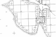
Interbay, Seattle, Washington
Encyclopedia

Seattle, Washington
Seattle is the county seat of King County, Washington. With 608,660 residents as of the 2010 Census, Seattle is the largest city in the Northwestern United States. The Seattle metropolitan area of about 3.4 million inhabitants is the 15th largest metropolitan area in the country...
in the United States
United States
The United States of America is a federal constitutional republic comprising fifty states and a federal district...
consisting of the valley between Queen Anne Hill
Queen Anne, Seattle, Washington
Queen Anne Hill is a neighborhood and geographic feature in Seattle, Washington, northwest of downtown. The neighborhood sits on the highest named hill in the city, with a maximum elevation of . It covers an area of , and has a population of about 28,000...
on the east and Magnolia
Magnolia, Seattle, Washington
Magnolia is the second largest neighborhood of Seattle, Washington by area. It occupies a hilly peninsula northwest of downtown. Magnolia is isolated from the rest of Seattle, connected by road to the rest of the city by only three bridges over the tracks of the BNSF Railway: W. Emerson Place in...
on the west, plus filled-in areas of Smith Cove
Smith Cove (Washington)
Smith Cove is a body of water, the northern part of Seattle, Washington's Elliott Bay, immediately south of the area that has been known since 1894 as Interbay...
and Salmon Bay
Salmon Bay
Salmon Bay is that part of the Lake Washington Ship Canal--which passes through the city of Seattle, linking Lake Washington to Puget Sound--that lies west of the Fremont Cut. It is the westernmost section of the canal, and empties into Shilshole Bay, which is part of Puget Sound. Because of the...
. The neighborhood is bounded on the north by Salmon Bay, part of the Lake Washington Ship Canal
Lake Washington Ship Canal
The Lake Washington Ship Canal, which runs through the City of Seattle, Washington, connects the fresh water body of Lake Washington with the salt water inland sea of Puget Sound. The Ship Canal includes a series of locks, modeled after the Panama Canal, to accommodate the different water levels...
, across which is Ballard
Ballard, Seattle, Washington
Ballard is a neighborhood located in the northwestern part of Seattle, Washington. To the north it is bounded by Crown Hill, ; to the east by Greenwood, Phinney Ridge and Fremont ; to the south by the Lake Washington Ship Canal; and to the west by Puget Sound’s Shilshole Bay. The neighborhood’s...
; on the south by what remains of Smith Cove, an inlet of Elliott Bay
Elliott Bay
Elliott Bay is the body of water on which Seattle, Washington, is located. A line drawn from Alki Point in the south to West Point in the north serves to mark the generally accepted division between the bay and the open sound...
; on the east by 15th Avenue W. and Elliott Avenue W.; and on the west by Thorndyke, 20th, and Gilman Avenues W. The Ballard Bridge
Ballard Bridge
The Ballard Bridge, also known as the 15th Avenue Bridge, is a double-leaf bascule bridge in Seattle, Washington, United States. It carries 15th Avenue NW over Seattle's Salmon Bay between Ballard and Interbay. Built in 1917, it has an opening span of and a total length of . It was added to the...
crosses the ship canal from Interbay to Ballard.
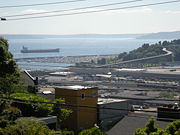
Much of Interbay is taken up by BNSF Railway
BNSF Railway
The BNSF Railway is a wholly owned subsidiary of Berkshire Hathaway Inc., and is headquartered in Fort Worth, Texas. It is one of seven North American Class I railroads and the second largest freight railroad network in North America, second only to the Union Pacific Railroad, its primary...
's Balmer Yard
Balmer Yard
Balmer Yard is a rail yard located in the Interbay neighborhood of Seattle, Washington. The yard is owned by BNSF Railway, and was built by predecessor Great Northern Railway as Interbay Yard. As part of a modernization in the late 1960s, which included a 16-track hump, it was renamed after former...
. Interbay is also home to Fishermen's Terminal
Fishermen's Terminal
Fishermen's Terminal is located on Salmon Bay in the Interbay neighborhood in Seattle, Washington, east of the Hiram M. Chittenden Locks and immediately west of the Ballard Bridge....
on Salmon Bay and the Port of Seattle
Port of Seattle
The Port of Seattle is a port district that runs Seattle's seaport and airport. Its creation was approved by the voters of King County, Washington, on September 5, 1911, authorized by the Port District Act. It is run by a five-member commission. The commissioners' terms run four years...
's Piers 86, 90, and 91 on Smith Cove. Its main thoroughfares are Elliott Avenue W. (northwest- and southeast-bound) and 15th Avenue W. (north- and southbound).
History
Sand
Sand is a naturally occurring granular material composed of finely divided rock and mineral particles.The composition of sand is highly variable, depending on the local rock sources and conditions, but the most common constituent of sand in inland continental settings and non-tropical coastal...
throughout the area may date from a tsunami
Tsunami
A tsunami is a series of water waves caused by the displacement of a large volume of a body of water, typically an ocean or a large lake...
following an earthquake
Earthquake
An earthquake is the result of a sudden release of energy in the Earth's crust that creates seismic waves. The seismicity, seismism or seismic activity of an area refers to the frequency, type and size of earthquakes experienced over a period of time...
along the Seattle Fault Zone about 1,000 years ago.
Although Interbay fell within the traditional geographic range of the Duwamish, early ethnographers did not record contact-era or earlier Native American villages in the area. Nonetheless, University of Washington
University of Washington
University of Washington is a public research university, founded in 1861 in Seattle, Washington, United States. The UW is the largest university in the Northwest and the oldest public university on the West Coast. The university has three campuses, with its largest campus in the University...
ethnologist T. T. Waterman lists several native place names at or near Smith Cove and Salmon Bay.
The Denny Party
Denny Party
The Denny Party is a group of white pioneers credited with founding Seattle, Washington because they settled at Alki Point on November 13, 1851.A wagon party headed by Arthur A. Denny left Cherry Grove, Illinois on April 10, 1851...
saw Interbay's development potential when they explored the area in 1852, but chose to settle farther south. Their settlement became the core of Seattle. Meanwhile, most of Interbay came to be owned by Ohio
Ohio
Ohio is a Midwestern state in the United States. The 34th largest state by area in the U.S.,it is the 7th‑most populous with over 11.5 million residents, containing several major American cities and seven metropolitan areas with populations of 500,000 or more.The state's capital is Columbus...
-born physician and poet Henry A. Smith
Henry A. Smith
Dr. Henry A. Smith was a physician, poet, legislator and early settler of Seattle, best known today for his flowery translation of a speech by Chief Seattle that is still in print....
(1830–1915), after whom Smith's Cove is now named. Smith and his wife, mother, and sister began with a claim
Donation Land Claim Act
The Donation Land Claim Act of 1850 was a statute enacted by the United States Congress intended to promote homestead settlement in the Oregon Territory in the Pacific Northwest...
on Salmon Bay
Salmon Bay
Salmon Bay is that part of the Lake Washington Ship Canal--which passes through the city of Seattle, linking Lake Washington to Puget Sound--that lies west of the Fremont Cut. It is the westernmost section of the canal, and empties into Shilshole Bay, which is part of Puget Sound. Because of the...
near the present-day Ballard
Ballard, Seattle, Washington
Ballard is a neighborhood located in the northwestern part of Seattle, Washington. To the north it is bounded by Crown Hill, ; to the east by Greenwood, Phinney Ridge and Fremont ; to the south by the Lake Washington Ship Canal; and to the west by Puget Sound’s Shilshole Bay. The neighborhood’s...
, and steadily acquired more land, extending their holdings south through Interbay to Smith Cove. In particular, the Smiths bought when so many other were selling during the 1855–56 Indian War (see Battle of Seattle (1856)
Battle of Seattle (1856)
The Battle of Seattle was a January 26, 1856 attack by native Americans upon Seattle, Washington. At the time, Seattle was a settlement in the Washington Territory that had recently named itself after Chief Seattle , a leader of the Suquamish and Duwamish peoples of central Puget Sound.Backed by...
).
Smith established a settlement known as Boulevard roughly halfway between Smith Cove and Salmon Bay, along a street he called Grand Boulevard (present-day West Dravus Street). He farmed, practiced medicine, and wrote. His most famous piece of writing, published in the 1880s, purported to be an English-language rendering of Chief Seattle
Chief Seattle
Chief Seattle , was a Dkhw’Duw’Absh chief, also known as Sealth, Seathle, Seathl, or See-ahth. A prominent figure among his people, he pursued a path of accommodation to white settlers, forming a personal relationship with David Swinson "Doc" Maynard. Seattle, Washington was named after him...
's speech on the occasion of an 1854 treaty conference; there is question about the authenticity of the translation.
In 1884 the Seattle, Lake Shore and Eastern Railway
Seattle, Lake Shore and Eastern Railway
The Seattle, Lake Shore and Eastern Railway was a railroad founded in Seattle, Washington, on April 28, 1885, with three tiers of purposes: Build and run the initial line to the town of Ballard, bring immediate results and returns to investors; exploit resources east in the valleys, foothills,...
(SLSER) purchased all but 50 acres (20.2 ha) of Smith's 9600 acres (3,885 ha) in Interbay and built a north-south rail line through the area. The train stopped on Grand Boulevard Street near Gilman and Thorndyke Avenues, spurring further commercial development and the rise of a blue-collar village. In 1891, Seattle annexed Magnolia and Interbay, including Boulevard. By 1894, the post office name had been changed from "Boulevard" to "Interbay", the name that has continued to this day.
The railway route through Interbay eventually came under the control of James J. Hill
James J. Hill
James Jerome Hill , was a Canadian-American railroad executive. He was the chief executive officer of a family of lines headed by the Great Northern Railway, which served a substantial area of the Upper Midwest, the northern Great Plains, and Pacific Northwest...
and the Great Northern Railway, as did much of at Smith Cove. Hill established a major depot and port at the cove, including Piers 38 and 39 (now demolished), which were located east of present-day Piers 90 and 91. In 1896 Nippon Yusen Kaisha established the first regular steamship service between Asia
Asia
Asia is the world's largest and most populous continent, located primarily in the eastern and northern hemispheres. It covers 8.7% of the Earth's total surface area and with approximately 3.879 billion people, it hosts 60% of the world's current human population...
and the Pacific Coast of North America, with Smith Cove as its American port.
During the 1911–1916 construction of the Lake Washington Ship Canal
Lake Washington Ship Canal
The Lake Washington Ship Canal, which runs through the City of Seattle, Washington, connects the fresh water body of Lake Washington with the salt water inland sea of Puget Sound. The Ship Canal includes a series of locks, modeled after the Panama Canal, to accommodate the different water levels...
along Salmon Bay, about 150 acres (60.7 ha) of Smith Cove tidelands were filled with material from the dredging. The then (1911) new Port of Seattle
Port of Seattle
The Port of Seattle is a port district that runs Seattle's seaport and airport. Its creation was approved by the voters of King County, Washington, on September 5, 1911, authorized by the Port District Act. It is run by a five-member commission. The commissioners' terms run four years...
built Fishermen's Terminal
Fishermen's Terminal
Fishermen's Terminal is located on Salmon Bay in the Interbay neighborhood in Seattle, Washington, east of the Hiram M. Chittenden Locks and immediately west of the Ballard Bridge....
on Salmon Bay at the north end of Interbay and bought the Great Northern docks and approximately 20 acres (8.1 ha) at Smith's Cove, where they developed two new coal and lumber piers, today's Piers 90 and 91. These developments at either end of Interbay led to the increasing industrialization of the area.
This maritime trade spurred the rise of companies in Interbay including rope factory Portland Cordage, Rudd Paint Manufacturing, Berquist's Vinegar Works, and the Chicago Junk Company (later Tsubota Steel and Pipe Company). Finns, Poles
Poles
thumb|right|180px|The state flag of [[Poland]] as used by Polish government and diplomatic authoritiesThe Polish people, or Poles , are a nation indigenous to Poland. They are united by the Polish language, which belongs to the historical Lechitic subgroup of West Slavic languages of Central Europe...
, Russians
Russians
The Russian people are an East Slavic ethnic group native to Russia, speaking the Russian language and primarily living in Russia and neighboring countries....
, Germans
Germans
The Germans are a Germanic ethnic group native to Central Europe. The English term Germans has referred to the German-speaking population of the Holy Roman Empire since the Late Middle Ages....
, Austrians
Austrians
Austrians are a nation and ethnic group, consisting of the population of the Republic of Austria and its historical predecessor states who share a common Austrian culture and Austrian descent....
, and Scots
Scottish people
The Scottish people , or Scots, are a nation and ethnic group native to Scotland. Historically they emerged from an amalgamation of the Picts and Gaels, incorporating neighbouring Britons to the south as well as invading Germanic peoples such as the Anglo-Saxons and the Norse.In modern use,...
figured prominently among those who settled and worked in the neighborhood.
The Asian trade out of Smith Cove continued until 1934, when the violence there accompanying the Maritime Strike of 1934 led to a diversion of this trade to the Port of Los Angeles
Port of Los Angeles
The Port of Los Angeles, also called Los Angeles Harbor and WORLDPORT L.A, is a port complex that occupies of land and water along of waterfront. The port is located on San Pedro Bay in the San Pedro neighborhood of Los Angeles, approximately south of downtown...
.
During the Great Depression
Great Depression
The Great Depression was a severe worldwide economic depression in the decade preceding World War II. The timing of the Great Depression varied across nations, but in most countries it started in about 1929 and lasted until the late 1930s or early 1940s...
, Interbay was the site of one of Seattle's Hooverville
Hooverville
A 'Hooverville' was the popular name for shanty towns built by homeless people during the Great Depression. They were named after the President of the United States at the time, Herbert Hoover, because he allegedly let the nation slide into depression...
s.
From 1941 into the early 1970s, Smith Cove served as a depot for the United States Navy
United States Navy
The United States Navy is the naval warfare service branch of the United States Armed Forces and one of the seven uniformed services of the United States. The U.S. Navy is the largest in the world; its battle fleet tonnage is greater than that of the next 13 largest navies combined. The U.S...
, before returning to use as a civilian port.
Bridging Interbay
Fort Lawton
Fort Lawton is a United States Army fort located in the Magnolia neighborhood of Seattle, Washington. The fort was included in the 2005 Base Realignment and Closure list.-History:...
street trolley
Tram
A tram is a passenger rail vehicle which runs on tracks along public urban streets and also sometimes on separate rights of way. It may also run between cities and/or towns , and/or partially grade separated even in the cities...
line. The first of several bridges across Smith Cove at Garfield Street Bridge (site of the current Magnolia Bridge
Magnolia Bridge
The Magnolia Bridge, built in 1930, connects the neighborhoods of Magnolia and Interbay over the filled-in tidelands of Smith Cove. It is one of only three road connections from Magnolia to the rest of Seattle. It carries W. Garfield Street from Magnolia Way W. in the west to the intersection of...
) was built some time between 1910 and 1912. The 23rd Avenue West trestle and the South Shore trestle were both western extensions of the West Garfield Street Bridge, leading to different points in Magnolia to the West. The Wheeler Street Bridge was a complex of four trestles. The Wheeler Street West trestle ran from 15th
Avenue West to Thorndyke Avenue West. The Lawton Way trestle intersected that at a diagonal and trestle extensions ran to both 20th Avenue West and Halliday Street on the Magnolia Bluffs.
As of 2008, besides the Magnolia Bridge over the former tideflats and the West Dravus trestle, Interbay is also spanned by a flyover from Nickerson Street at West Emerson Place, just south of Salmon Bay and the Fishermen's Terminal, near the south end of the Ballard Bridge
Ballard Bridge
The Ballard Bridge, also known as the 15th Avenue Bridge, is a double-leaf bascule bridge in Seattle, Washington, United States. It carries 15th Avenue NW over Seattle's Salmon Bay between Ballard and Interbay. Built in 1917, it has an opening span of and a total length of . It was added to the...
. There is no longer a crossing at Wheeler Street (just south of the Interbay Golf Course).
Interbay today
Interbay today remains home to BNSF RailwayBNSF Railway
The BNSF Railway is a wholly owned subsidiary of Berkshire Hathaway Inc., and is headquartered in Fort Worth, Texas. It is one of seven North American Class I railroads and the second largest freight railroad network in North America, second only to the Union Pacific Railroad, its primary...
's Balmer Yard
Balmer Yard
Balmer Yard is a rail yard located in the Interbay neighborhood of Seattle, Washington. The yard is owned by BNSF Railway, and was built by predecessor Great Northern Railway as Interbay Yard. As part of a modernization in the late 1960s, which included a 16-track hump, it was renamed after former...
and related locomotive maintenance shops, the Port of Seattle's Fishermen's Terminal on Salmon Bay and Piers 86, 90, and 91 on Smith Cove, and related facilities. It is also home to a Washington Army National Guard
Army National Guard
Established under Title 10 and Title 32 of the U.S. Code, the Army National Guard is part of the National Guard and is divided up into subordinate units stationed in each of the 50 states, three territories and the District of Columbia operating under their respective governors...
armory, Interbay Stadium
Interbay Stadium
Interbay Stadium is a 1000-seat soccer-specific stadium in Interbay, a neighborhood of Seattle, Washington....
, the Interbay P-Patch
Interbay p-patch
Interbay P-Patch, "The Garden Between The Bays", is one of Seattle, Washington's largest and most involved community gardens, and is recognized as an example of resourcefulness and sustainability.- Overview :...
(a large community garden), and the Interbay Golf Course. Five late 19th century houses near Smith Cove, known as the Fourteenth Avenue West Group, have official status as a city landmark. There is a miscellany of light industrial, warehouse, wholesale, and retail businesses along 15th Avenue West, as well as a few professional offices and some housing. There continues to be a small shopping and dining neighborhood at West Dravus Street, the former Grand Boulevard. Just north of Dravus on 15th are the Quest Church and the nonprofit (and non-religious) Q Café, founded with funding from the church. Near the Magnolia Bridge on 15th is the Center for Sex Positive Culture
Center for Sex Positive Culture
The Center for Sex Positive Culture or CSPC is a non-profit, membership-based organization located in Seattle, Washington. It organizes events and provides space for several different sex-positive subcultures, notably BDSM, swinging, and polyamory groups. It caters to both heterosexual and LGBT...
. A bicycle and foot trail comes north from the Central Waterfront by Belltown
Belltown, Seattle, Washington
Belltown is a neighborhood in Seattle, Washington, United States, in the 98121 Zip Code, located on the city's downtown waterfront, on land that was artificially flattened as part of a regrading project...
through Myrtle Edwards Park
Myrtle Edwards Park
Myrtle Edwards Park in Seattle, Washington is a 4.8 acre public park along the Elliott Bay waterfront north of Belltown. It features a 1.25-mile long bicycle and walking path and is a good place to see eagles, gulls, and crows....
continues through the pier facilities around Smith Cove and parallels the railway tracks on their west through Interbay, ending on the west (Magnolia) side of the tracks on 20th Avenue West about three blocks south of Dravus.