
.gif)
Hurricane Daniel (2006)
Encyclopedia
Hurricane Daniel was the second strongest hurricane
of the 2006 Pacific hurricane season
. The fourth named storm of the season, Daniel originated on July 16 from a tropical wave
off the coast of Mexico
. It tracked westward, intensifying steadily to reach peak winds of 150 mph (240 km/h) on July 22. At the time, the characteristics of the cyclone resembled those of an annular hurricane
. Daniel gradually weakened as it entered an area of cooler water temperatures and increased wind shear, and after crossing into the Central Pacific Ocean
, it quickly degenerated into a remnant low pressure area on July 26.
Initial predictions suggested that the cyclone would pass through the Hawaiian Islands
as a tropical storm; however, Daniel's remnants dissipated southeast of Hawaii
. The storm brought light to moderate precipitation to the islands of Hawaii and Maui
, causing minor flooding, although no major damage or fatalities were reported.
that moved off the west coast of Africa
on July 2. The wave moved across the Atlantic Ocean
and Caribbean Sea
with little associated convection, and on July 12, it crossed Central America
into the eastern Pacific Ocean
. Convection increased on July 13, and two days later the system began to exhibit signs of tropical development to the south of Mexico
. It tracked westward at about 15 mph (25 km/h), and on July 16, the disturbance became better organized. With convective rainbands near an associated low-level circulation, it is estimated the tropical wave spawned a tropical depression late on July 16. At the time, it was located about 525 miles (845 km) south-southwest of Manzanillo, Colima
.
Classified as Tropical Depression Five-E, the system tracked westward under the steering currents of a mid-level ridge
. In the hours after formation, the depression lacked a concentration of deep convection near the center. Conditions favored development
, including warm sea surface temperatures, very low amounts of wind shear
, and an established anticyclone
over the cyclone. Convection became more centralized, coinciding with the improvement of upper-level outflow
. Based on Dvorak classifications
, it is estimated that the cyclone intensified into Tropical Storm Daniel at 1200 UTC on July 17. Daniel quickly became better organized, exhibiting increased thunderstorm activity and banding features
. A central dense overcast
developed, and a well-defined rainband wrapped around the center of circulation. Based on the formation of an eye feature
, the National Hurricane Center
upgraded Daniel to hurricane status late on July 18 while it was located about 885 miles (1420 km) south-southwest of Cabo San Lucas
.
 On July 19, the eye of Daniel became apparent on satellite imagery, which organized into a pinhole eye. It underwent an eyewall replacement cycle
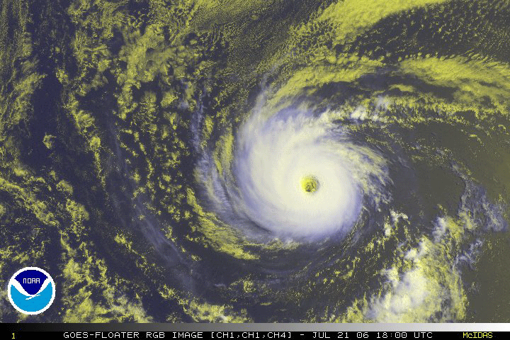
as it turned to the west-northwest, temporarily halting its intensification trend, before quickly strengthening and attaining major hurricane status
on July 20. Later that day, Hurricane Daniel organized into a very symmetric cyclone with a distinct eye about 30 miles (50 km) in diameter. Upon attaining Category 4 status on the Saffir-Simpson Hurricane Scale
, the cyclone resembled the appearance of an annular hurricane
; an annular hurricane is one with a large and symmetric eye, surrounded by a thick ring of intense convection, and usually is able to maintain its intensity and structure for several days. On July 21 the hurricane underwent another eyewall replacement cycle. After completing the cycle, Daniel attained its peak winds of 150 mph (240 km/h) early on July 22. It maintained peak winds for about 18 hours, and Daniel began a weakening trend as it crossed into an area of progressively cooler water temperatures. The eye became more distinct on July 23, before the cloud tops again warmed as the winds decreased.
The hurricane crossed into the area of forecast responsibility of the Central Pacific Hurricane Center
on July 24, and upon doing so, its eye disappeared from satellite imagery. Daniel was forecast to track through the Hawaiian Islands
as a tropical storm as water temperatures near the islands were warmer, and wind shear
was expected to be minimal. However, it decelerated as the ridge to its north weakened, and due to the combination of cool waters and increasing easterly shear, Daniel weakened to a tropical storm on July 25. Later that day, no active convection remained near the exposed circulation center, and early on July 26 it weakened to tropical depression status. Thunderstorm activity failed to redevelop, and Daniel degenerated into a remnant low pressure area
by 0000 UTC
on July 27. The remnant low continued west-northwestward, dissipating just south-east of the Big Island
of Hawaii on July 28.
.jpg) When Hurricane Daniel was forecast to pass through the Hawaiian islands as a tropical storm, state and Hawaii County
When Hurricane Daniel was forecast to pass through the Hawaiian islands as a tropical storm, state and Hawaii County
officials recommended residents prepare hurricane kits. They also suggested purchasing non-perishable foods and batteries. Initially, the storm was several days away from potentially affecting the state, and as a result few residents rushed to prepare. The Honolulu National Weather Service
issued a high surf advisory for east facing beaches in Hawaii, and warned beachgoers to remain out of the water. The National Weather Service issued a flash flood
watch and wind advisory in association with the remnants of Daniel.
The remnants produced 2–5 inches (50–125 mm) of rainfall throughout windward areas of the Big Island
of Hawaii and Maui
on July 28 and 29. West Wailuaiki on Maui recorded 3.87 inches (98.3 mm) in one day, which was the highest daily rainfall total from the hurricane. The storm also dropped precipitation on the East Maui watershed. The rainfall—particularly in Kailua-Kona on the Big Island—caused ponding
on roadways, as well as flooding of small streams. However, no injuries or serious damage were reported. A station in Ka Lae
briefly reported sustained winds of about 35 mph (55 km/h) with gusts to 45 mph (75 km/h).
During the 61st Interdepartmental Hurricane Conference, the Hawaii State Civil Defense requested the retirement of the name Daniel, citing that it became one of the several storms memorable for threat or damage. However, the World Meteorological Organization
did not approve the request, and the name remains on the list to be used during the 2012 season.
Pacific hurricane
A Pacific hurricane or tropical storm is a tropical cyclone that develops in the northeastern part of the Pacific Ocean. For organizational purposes, the northern Pacific Ocean is divided into three regions: the eastern, , central , and western...
of the 2006 Pacific hurricane season
2006 Pacific hurricane season
The 2006 Pacific hurricane season was the most active Pacific hurricane season since 2000 producing 19 tropical storms or hurricanes. Eighteen developed within the National Hurricane Center area of warning responsibility, which is east of 140ºW, and one storm formed between 140ºW and the...
. The fourth named storm of the season, Daniel originated on July 16 from a tropical wave
Tropical wave
Tropical waves, easterly waves, or tropical easterly waves, also known as African easterly waves in the Atlantic region, are a type of atmospheric trough, an elongated area of relatively low air pressure, oriented north to south, which move from east to west across the tropics causing areas of...
off the coast of Mexico
Mexico
The United Mexican States , commonly known as Mexico , is a federal constitutional republic in North America. It is bordered on the north by the United States; on the south and west by the Pacific Ocean; on the southeast by Guatemala, Belize, and the Caribbean Sea; and on the east by the Gulf of...
. It tracked westward, intensifying steadily to reach peak winds of 150 mph (240 km/h) on July 22. At the time, the characteristics of the cyclone resembled those of an annular hurricane
Annular hurricane
An annular hurricane, also known as a truck tire or doughnut hurricane, is a tropical cyclone in the Atlantic or Eastern Pacific Oceans that features a large, symmetric eye surrounded by a thick ring of intense convection. This type of storm is not prone to the fluctuations in intensity associated...
. Daniel gradually weakened as it entered an area of cooler water temperatures and increased wind shear, and after crossing into the Central Pacific Ocean
Central Pacific Hurricane Center
The Central Pacific Hurricane Center of the United States National Weather Service is the official body responsible for tracking and issuing tropical cyclone warnings, watches, advisories, discussions, and statements for the Central North Pacific Basin...
, it quickly degenerated into a remnant low pressure area on July 26.
Initial predictions suggested that the cyclone would pass through the Hawaiian Islands
Hawaiian Islands
The Hawaiian Islands are an archipelago of eight major islands, several atolls, numerous smaller islets, and undersea seamounts in the North Pacific Ocean, extending some 1,500 miles from the island of Hawaii in the south to northernmost Kure Atoll...
as a tropical storm; however, Daniel's remnants dissipated southeast of Hawaii
Hawaii (island)
The Island of Hawaii, also called the Big Island or Hawaii Island , is a volcanic island in the North Pacific Ocean...
. The storm brought light to moderate precipitation to the islands of Hawaii and Maui
Maui
The island of Maui is the second-largest of the Hawaiian Islands at and is the 17th largest island in the United States. Maui is part of the state of Hawaii and is the largest of Maui County's four islands, bigger than Lānai, Kahoolawe, and Molokai. In 2010, Maui had a population of 144,444,...
, causing minor flooding, although no major damage or fatalities were reported.
Meteorological history
Hurricane Daniel began as a tropical waveTropical wave
Tropical waves, easterly waves, or tropical easterly waves, also known as African easterly waves in the Atlantic region, are a type of atmospheric trough, an elongated area of relatively low air pressure, oriented north to south, which move from east to west across the tropics causing areas of...
that moved off the west coast of Africa
Africa
Africa is the world's second largest and second most populous continent, after Asia. At about 30.2 million km² including adjacent islands, it covers 6% of the Earth's total surface area and 20.4% of the total land area...
on July 2. The wave moved across the Atlantic Ocean
Atlantic Ocean
The Atlantic Ocean is the second-largest of the world's oceanic divisions. With a total area of about , it covers approximately 20% of the Earth's surface and about 26% of its water surface area...
and Caribbean Sea
Caribbean Sea
The Caribbean Sea is a sea of the Atlantic Ocean located in the tropics of the Western hemisphere. It is bounded by Mexico and Central America to the west and southwest, to the north by the Greater Antilles, and to the east by the Lesser Antilles....
with little associated convection, and on July 12, it crossed Central America
Central America
Central America is the central geographic region of the Americas. It is the southernmost, isthmian portion of the North American continent, which connects with South America on the southeast. When considered part of the unified continental model, it is considered a subcontinent...
into the eastern Pacific Ocean
Pacific Ocean
The Pacific Ocean is the largest of the Earth's oceanic divisions. It extends from the Arctic in the north to the Southern Ocean in the south, bounded by Asia and Australia in the west, and the Americas in the east.At 165.2 million square kilometres in area, this largest division of the World...
. Convection increased on July 13, and two days later the system began to exhibit signs of tropical development to the south of Mexico
Mexico
The United Mexican States , commonly known as Mexico , is a federal constitutional republic in North America. It is bordered on the north by the United States; on the south and west by the Pacific Ocean; on the southeast by Guatemala, Belize, and the Caribbean Sea; and on the east by the Gulf of...
. It tracked westward at about 15 mph (25 km/h), and on July 16, the disturbance became better organized. With convective rainbands near an associated low-level circulation, it is estimated the tropical wave spawned a tropical depression late on July 16. At the time, it was located about 525 miles (845 km) south-southwest of Manzanillo, Colima
Manzanillo, Colima
The name Manzanillo refers to the city as well as its surrounding municipality in the Mexican state of Colima. The city, located on the Pacific Ocean, contains Mexico's busiest port. Manzanillo was the third port created by the Spanish in the Pacific during the New Spain period...
.
Classified as Tropical Depression Five-E, the system tracked westward under the steering currents of a mid-level ridge
Ridge (meteorology)
A ridge is an elongated region of relatively high atmospheric pressure, the opposite of a trough....
. In the hours after formation, the depression lacked a concentration of deep convection near the center. Conditions favored development
Tropical cyclogenesis
Tropical cyclogenesis is the term that describes the development and strengthening of a tropical cyclone in the atmosphere. The mechanisms through which tropical cyclogenesis occurs are distinctly different from those through which mid-latitude cyclogenesis occurs...
, including warm sea surface temperatures, very low amounts of wind shear
Wind shear
Wind shear, sometimes referred to as windshear or wind gradient, is a difference in wind speed and direction over a relatively short distance in the atmosphere...
, and an established anticyclone
Anticyclone
An anticyclone is a weather phenomenon defined by the United States' National Weather Service's glossary as "[a] large-scale circulation of winds around a central region of high atmospheric pressure, clockwise in the Northern Hemisphere, counterclockwise in the Southern Hemisphere"...
over the cyclone. Convection became more centralized, coinciding with the improvement of upper-level outflow
Outflow (meteorology)
Outflow, in meteorology, is air that flows outwards from a storm system. It is associated with ridging, or anticyclonic flow. In the low levels of the troposphere, outflow radiates from thunderstorms in the form of a wedge of rain-cooled air, which is visible as a thin rope-like cloud on weather...
. Based on Dvorak classifications
Dvorak technique
The Dvorak technique is a widely used system to subjectively estimate tropical cyclone intensity based solely on visible and infrared satellite images. Several agencies issue Dvorak intensity numbers for cyclones of sufficient intensity...
, it is estimated that the cyclone intensified into Tropical Storm Daniel at 1200 UTC on July 17. Daniel quickly became better organized, exhibiting increased thunderstorm activity and banding features
Rainband
A rainband is a cloud and precipitation structure associated with an area of rainfall which is significantly elongated. Rainbands can be stratiform or convective, and are generated by differences in temperature. When noted on weather radar imagery, this precipitation elongation is referred to as...
. A central dense overcast
Eye (cyclone)
The eye is a region of mostly calm weather found at the center of strong tropical cyclones. The eye of a storm is a roughly circular area and typically 30–65 km in diameter. It is surrounded by the eyewall, a ring of towering thunderstorms where the second most severe weather of a cyclone...
developed, and a well-defined rainband wrapped around the center of circulation. Based on the formation of an eye feature
Eye (cyclone)
The eye is a region of mostly calm weather found at the center of strong tropical cyclones. The eye of a storm is a roughly circular area and typically 30–65 km in diameter. It is surrounded by the eyewall, a ring of towering thunderstorms where the second most severe weather of a cyclone...
, the National Hurricane Center
National Hurricane Center
The National Hurricane Center , located at Florida International University in Miami, Florida, is the division of the National Weather Service responsible for tracking and predicting weather systems within the tropics between the Prime Meridian and the 140th meridian west poleward to the 30th...
upgraded Daniel to hurricane status late on July 18 while it was located about 885 miles (1420 km) south-southwest of Cabo San Lucas
Cabo San Lucas
Cabo San Lucas , commonly called Cabo, is a city at the southern tip of the Baja California peninsula, in the municipality of Los Cabos in the Mexican state of Baja California Sur. As of the 2010 census, the population was 68,463 people...
.
Eyewall replacement cycle
Eyewall replacement cycles, also called concentric eyewall cycles, naturally occur in intense tropical cyclones, generally with winds greater than 185 km/h , or major hurricanes...
as it turned to the west-northwest, temporarily halting its intensification trend, before quickly strengthening and attaining major hurricane status
Tropical cyclone scales
Tropical systems are officially ranked on one of several tropical cyclone scales according to their maximum sustained winds and in what oceanic basin they are located...
on July 20. Later that day, Hurricane Daniel organized into a very symmetric cyclone with a distinct eye about 30 miles (50 km) in diameter. Upon attaining Category 4 status on the Saffir-Simpson Hurricane Scale
Saffir-Simpson Hurricane Scale
The Saffir–Simpson Hurricane Scale , or the Saffir–Simpson Hurricane Wind Scale , classifies hurricanes — Western Hemisphere tropical cyclones that exceed the intensities of tropical depressions and tropical storms — into five categories distinguished by the intensities of their sustained winds...
, the cyclone resembled the appearance of an annular hurricane
Annular hurricane
An annular hurricane, also known as a truck tire or doughnut hurricane, is a tropical cyclone in the Atlantic or Eastern Pacific Oceans that features a large, symmetric eye surrounded by a thick ring of intense convection. This type of storm is not prone to the fluctuations in intensity associated...
; an annular hurricane is one with a large and symmetric eye, surrounded by a thick ring of intense convection, and usually is able to maintain its intensity and structure for several days. On July 21 the hurricane underwent another eyewall replacement cycle. After completing the cycle, Daniel attained its peak winds of 150 mph (240 km/h) early on July 22. It maintained peak winds for about 18 hours, and Daniel began a weakening trend as it crossed into an area of progressively cooler water temperatures. The eye became more distinct on July 23, before the cloud tops again warmed as the winds decreased.
The hurricane crossed into the area of forecast responsibility of the Central Pacific Hurricane Center
Central Pacific Hurricane Center
The Central Pacific Hurricane Center of the United States National Weather Service is the official body responsible for tracking and issuing tropical cyclone warnings, watches, advisories, discussions, and statements for the Central North Pacific Basin...
on July 24, and upon doing so, its eye disappeared from satellite imagery. Daniel was forecast to track through the Hawaiian Islands
Hawaiian Islands
The Hawaiian Islands are an archipelago of eight major islands, several atolls, numerous smaller islets, and undersea seamounts in the North Pacific Ocean, extending some 1,500 miles from the island of Hawaii in the south to northernmost Kure Atoll...
as a tropical storm as water temperatures near the islands were warmer, and wind shear
Wind shear
Wind shear, sometimes referred to as windshear or wind gradient, is a difference in wind speed and direction over a relatively short distance in the atmosphere...
was expected to be minimal. However, it decelerated as the ridge to its north weakened, and due to the combination of cool waters and increasing easterly shear, Daniel weakened to a tropical storm on July 25. Later that day, no active convection remained near the exposed circulation center, and early on July 26 it weakened to tropical depression status. Thunderstorm activity failed to redevelop, and Daniel degenerated into a remnant low pressure area
Low pressure area
A low-pressure area, or "low", is a region where the atmospheric pressure at sea level is below that of surrounding locations. Low-pressure systems form under areas of wind divergence which occur in upper levels of the troposphere. The formation process of a low-pressure area is known as...
by 0000 UTC
Coordinated Universal Time
Coordinated Universal Time is the primary time standard by which the world regulates clocks and time. It is one of several closely related successors to Greenwich Mean Time. Computer servers, online services and other entities that rely on having a universally accepted time use UTC for that purpose...
on July 27. The remnant low continued west-northwestward, dissipating just south-east of the Big Island
Hawaii (island)
The Island of Hawaii, also called the Big Island or Hawaii Island , is a volcanic island in the North Pacific Ocean...
of Hawaii on July 28.
Preparations and impact
Hawaii County, Hawaii
Hawaii County is a county located in the U.S. state of Hawaii in the Hawaiian Islands. It is coterminous with the Island of Hawaii, often called the "Big Island" to distinguish it from the state as a whole. As of the 2010 Census the population was 185,079. The county seat is Hilo. There are no...
officials recommended residents prepare hurricane kits. They also suggested purchasing non-perishable foods and batteries. Initially, the storm was several days away from potentially affecting the state, and as a result few residents rushed to prepare. The Honolulu National Weather Service
National Weather Service
The National Weather Service , once known as the Weather Bureau, is one of the six scientific agencies that make up the National Oceanic and Atmospheric Administration of the United States government...
issued a high surf advisory for east facing beaches in Hawaii, and warned beachgoers to remain out of the water. The National Weather Service issued a flash flood
Flash flood
A flash flood is a rapid flooding of geomorphic low-lying areas—washes, rivers, dry lakes and basins. It may be caused by heavy rain associated with a storm, hurricane, or tropical storm or meltwater from ice or snow flowing over ice sheets or snowfields...
watch and wind advisory in association with the remnants of Daniel.
The remnants produced 2–5 inches (50–125 mm) of rainfall throughout windward areas of the Big Island
Hawaii (island)
The Island of Hawaii, also called the Big Island or Hawaii Island , is a volcanic island in the North Pacific Ocean...
of Hawaii and Maui
Maui
The island of Maui is the second-largest of the Hawaiian Islands at and is the 17th largest island in the United States. Maui is part of the state of Hawaii and is the largest of Maui County's four islands, bigger than Lānai, Kahoolawe, and Molokai. In 2010, Maui had a population of 144,444,...
on July 28 and 29. West Wailuaiki on Maui recorded 3.87 inches (98.3 mm) in one day, which was the highest daily rainfall total from the hurricane. The storm also dropped precipitation on the East Maui watershed. The rainfall—particularly in Kailua-Kona on the Big Island—caused ponding
Ponding
Ponding is a term that refers to the unwanted pooling of water, typically on a flat roof.-Cause:Most flat roof systems are designed with a slight pitch to shed water off the sides, usually into a scupper system or into an internal drainage system. When a scupper or drain is clogged or fails for...
on roadways, as well as flooding of small streams. However, no injuries or serious damage were reported. A station in Ka Lae
Ka Lae
Ka Lae , also known as South Point, is the southernmost point of the Big Island of Hawaii and of the 50 United States. The Ka Lae area is registered as a National Historic Landmark District under the name South Point Complex...
briefly reported sustained winds of about 35 mph (55 km/h) with gusts to 45 mph (75 km/h).
During the 61st Interdepartmental Hurricane Conference, the Hawaii State Civil Defense requested the retirement of the name Daniel, citing that it became one of the several storms memorable for threat or damage. However, the World Meteorological Organization
World Meteorological Organization
The World Meteorological Organization is an intergovernmental organization with a membership of 189 Member States and Territories. It originated from the International Meteorological Organization , which was founded in 1873...
did not approve the request, and the name remains on the list to be used during the 2012 season.
See also
- List of Hawaii hurricanes
- Other tropical cyclones of the same name
- List of storms in the 2006 Pacific hurricane season
- Timeline of the 2006 Pacific hurricane seasonTimeline of the 2006 Pacific hurricane seasonThe 2006 Pacific hurricane season was the most active since the 2000 season, producing produced 21 tropical depressions; 19 of which became tropical storms or hurricanes...