
.gif)
Hurricane Barry (1983)
Encyclopedia
Hurricane Barry was the fourth tropical depression, second hurricane and named storm
of the inactive 1983 Atlantic hurricane season
. Developing out of a tropical wave
on August 23, Barry quickly strengthened off the coast of Florida, reaching an initial peak intensity with winds of 60 mph (95 km/h). However, increased wind shear
caused the storm to weaken to a tropical depression before making landfall near Melbourne, Florida
, the next morning. Traveling almost due west, the storm regenerated and became a hurricane on August 28. The storm made landfall on the northern Mexican coastline later that day at peak intensity. Rapid weakening followed shortly after and the storm dissipated the next day. The storm had only minor effects in the United States but destroyed hundreds of homes and left over 400 homeless in northern Mexico. Despite the damage, there were no reports of fatalities or injuries.
which moved off the western coast of Africa on August 13, 1983. Strong wind shear
in the Atlantic basin
prevented significant development of the system as it traveled towards the west-northwest. Little convection
was associated with the disturbance as a result of the shear. While approaching the Bahamas on August 22, an upper-level trough
moved away from the system, which led to a decrease in the wind shear. The disturbance then entered this environment and spawned an area of low pressure
which intensified. On August 23, the low had become sufficiently organized to be declared Tropical Depression Four. Later that day, the depression quickly strengthened into a tropical storm and was given the name Barry by the National Hurricane Center
(NHC). About 12 hours after becoming a tropical storm, Barry reached its initial peak intensity with winds of 60 mph (95 km/h).
Barry then began a westerly course towards central Florida
. However, wind shear began to increase, causing the system to weaken. The NHC downgraded the storm back to a tropical depression on August 25. Barry made landfall near Melbourne, Florida
the same morning with winds of 35 mph (55 km/h). After crossing Florida, the depression traveled towards the west-southwest due to a strong upper-level flow. On August 27, Barry became sufficiently organized to be reclassified as a tropical storm while located in the central Gulf of Mexico
. The re-strengthening was the result of decreased wind shear and more favorable conditions over the Gulf. The storm continued to become better organized as it traveled nearly due west towards Mexico
. At 1200 UTC the next day, Barry was upgraded to a hurricane while located about 75 mi (120 km) southeast of Brownsville, Texas
. The hurricane continued to intensify until it made landfall about 35 mi (55 km) south-southeast of Brownsville at peak intensity with winds of 80 mph (130 km/h). The storm quickly weakened after landfall and dissipated the next day over northern Mexico.
.jpg)
from Jupiter Inlet, Florida to Savannah, Georgia
on August 24 at 1900 UTC
. The warning was discontinued from St. Augustine to Savannah the next day. The next was a gale warning issued for Brownsville, Texas
to Port O'Connor, Texas
on August 27. This was upgraded into a hurricane warning as Barry strengthened a few hours later, and then extended to Mansfield
. The warning was discontinued by late August 28. Over 4,000 people were evacuated from South Padre Island
in preparation of Hurricane Barry. Several thousand people were evacuated from beaches in Port Aransas
on August 27 as Barry approached. An estimated 700 people took refuge in shelters set up in Brownsville and 800 people fled to schools, which were being used as temporary shelters, in Harlingen
. An additional 2,000 residents evacuated from Harlingen. Shelters were also opened in San Benito
, Santa Rosa
, and Los Fresnos
. Offshore, several oil platforms were evacuated in the Gulf of Mexico
.
, located south of Brownsville, Texas, Captain Manuel Leon Lopez warned residents about the approaching hurricane through radio messages. Many people were seen leaving coastal villages and heading further inland. Mexican officials raised the alert level to stage three due to the threat of Barry.
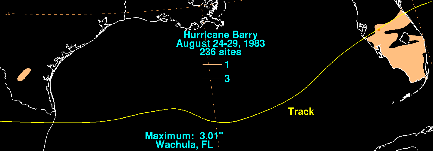
, 3 inches (76.2 mm) around the Orlando
area and 1 in (25 mm) in the Miami area. The peak rainfall was 3.01 in (76 mm) in Wachula, Florida. Roads with poor drainage in Key West, Florida
were flooded after the area received 1.5 in (38.1 mm) of rain. Barry also affected the launch of the Space Shuttle
Challenger
, whose third mission
was scheduled for August 30. NASA
(National Aeronautics and Space Administration) did not have time to return the shuttle to the hangar in time for the storm and had the shuttle ride out the storm on the launch pad. The only rainfall reported in Texas by Barry was 1 inches (25.4 mm) around San Antonio. Along the Texas coast, beach erosion was caused from waves that were 1 to 2 ft (0.3048 to 0.6096 m) higher than normal. Winds were gusting in excess of 50 mph (85 km/h) off the South Padre Island coast. Near Brownsville
, a possible tornado
knocked down power lines, leaving an estimated 6,000 people without power.
of 3 to 4 ft (0.9144 to 1.2 m) was recorded in Mexican fishing villages. Over 400 people were made homeless and there was a major loss of shrimping nets. At least ten people were left homeless in the town of El Mezquital. Homes in Santa Teresa sustained some damage but none were destroyed. Only one person was injured by the storm after shards from a broken window hit the child. Following the storm, General Jesus Ponce de Leon Rodriguez went to survey the damage in Tamaulipas
along with a medical team.
Tropical cyclone naming
Tropical cyclones have officially been named since 1945 and are named for a variety of reasons, which include to facilitate communications between forecasters and the public when forecasts, watches, and warnings are issued. Names also reduce confusion about what storm is being described, as more...
of the inactive 1983 Atlantic hurricane season
1983 Atlantic hurricane season
The 1983 Atlantic hurricane season was the least active Atlantic hurricane season in 53 years, with only four tropical storms forming. The season officially began on June 1, 1983, and lasted until November 30, 1983. These dates conventionally delimit the period of each year when most storms...
. Developing out of a tropical wave
Tropical wave
Tropical waves, easterly waves, or tropical easterly waves, also known as African easterly waves in the Atlantic region, are a type of atmospheric trough, an elongated area of relatively low air pressure, oriented north to south, which move from east to west across the tropics causing areas of...
on August 23, Barry quickly strengthened off the coast of Florida, reaching an initial peak intensity with winds of 60 mph (95 km/h). However, increased wind shear
Wind shear
Wind shear, sometimes referred to as windshear or wind gradient, is a difference in wind speed and direction over a relatively short distance in the atmosphere...
caused the storm to weaken to a tropical depression before making landfall near Melbourne, Florida
Melbourne, Florida
Melbourne is a city in Brevard County, Florida, United States. As of 2009, the population estimated by the U.S. Census Bureau is 78,323. The municipal area is the second largest by size and by population in the county. Melbourne is a principal city of the Palm Bay – Melbourne – Titusville, Florida...
, the next morning. Traveling almost due west, the storm regenerated and became a hurricane on August 28. The storm made landfall on the northern Mexican coastline later that day at peak intensity. Rapid weakening followed shortly after and the storm dissipated the next day. The storm had only minor effects in the United States but destroyed hundreds of homes and left over 400 homeless in northern Mexico. Despite the damage, there were no reports of fatalities or injuries.
Meteorological history
The origins of Hurricane Barry can be traced to a tropical waveTropical wave
Tropical waves, easterly waves, or tropical easterly waves, also known as African easterly waves in the Atlantic region, are a type of atmospheric trough, an elongated area of relatively low air pressure, oriented north to south, which move from east to west across the tropics causing areas of...
which moved off the western coast of Africa on August 13, 1983. Strong wind shear
Wind shear
Wind shear, sometimes referred to as windshear or wind gradient, is a difference in wind speed and direction over a relatively short distance in the atmosphere...
in the Atlantic basin
Atlantic hurricane
North Atlantic tropical cyclones usually form in the northern hemisphere summer or fall. Tropical cyclones can be categorized by intensity. Tropical storms have one-minute maximum sustained winds of at least 39 mph , while hurricanes have one-minute maximum sustained exceeding 74 mph...
prevented significant development of the system as it traveled towards the west-northwest. Little convection
Atmospheric convection
Atmospheric convection is the result of a parcel-environment instability, or temperature difference, layer in the atmosphere. Different lapse rates within dry and moist air lead to instability. Mixing of air during the day which expands the height of the planetary boundary layer leads to...
was associated with the disturbance as a result of the shear. While approaching the Bahamas on August 22, an upper-level trough
Trough (meteorology)
A trough is an elongated region of relatively low atmospheric pressure, often associated with fronts.Unlike fronts, there is not a universal symbol for a trough on a weather chart. The weather charts in some countries or regions mark troughs by a line. In the United States, a trough may be marked...
moved away from the system, which led to a decrease in the wind shear. The disturbance then entered this environment and spawned an area of low pressure
Low pressure area
A low-pressure area, or "low", is a region where the atmospheric pressure at sea level is below that of surrounding locations. Low-pressure systems form under areas of wind divergence which occur in upper levels of the troposphere. The formation process of a low-pressure area is known as...
which intensified. On August 23, the low had become sufficiently organized to be declared Tropical Depression Four. Later that day, the depression quickly strengthened into a tropical storm and was given the name Barry by the National Hurricane Center
National Hurricane Center
The National Hurricane Center , located at Florida International University in Miami, Florida, is the division of the National Weather Service responsible for tracking and predicting weather systems within the tropics between the Prime Meridian and the 140th meridian west poleward to the 30th...
(NHC). About 12 hours after becoming a tropical storm, Barry reached its initial peak intensity with winds of 60 mph (95 km/h).
Barry then began a westerly course towards central Florida
Florida
Florida is a state in the southeastern United States, located on the nation's Atlantic and Gulf coasts. It is bordered to the west by the Gulf of Mexico, to the north by Alabama and Georgia and to the east by the Atlantic Ocean. With a population of 18,801,310 as measured by the 2010 census, it...
. However, wind shear began to increase, causing the system to weaken. The NHC downgraded the storm back to a tropical depression on August 25. Barry made landfall near Melbourne, Florida
Melbourne, Florida
Melbourne is a city in Brevard County, Florida, United States. As of 2009, the population estimated by the U.S. Census Bureau is 78,323. The municipal area is the second largest by size and by population in the county. Melbourne is a principal city of the Palm Bay – Melbourne – Titusville, Florida...
the same morning with winds of 35 mph (55 km/h). After crossing Florida, the depression traveled towards the west-southwest due to a strong upper-level flow. On August 27, Barry became sufficiently organized to be reclassified as a tropical storm while located in the central Gulf of Mexico
Gulf of Mexico
The Gulf of Mexico is a partially landlocked ocean basin largely surrounded by the North American continent and the island of Cuba. It is bounded on the northeast, north and northwest by the Gulf Coast of the United States, on the southwest and south by Mexico, and on the southeast by Cuba. In...
. The re-strengthening was the result of decreased wind shear and more favorable conditions over the Gulf. The storm continued to become better organized as it traveled nearly due west towards Mexico
Mexico
The United Mexican States , commonly known as Mexico , is a federal constitutional republic in North America. It is bordered on the north by the United States; on the south and west by the Pacific Ocean; on the southeast by Guatemala, Belize, and the Caribbean Sea; and on the east by the Gulf of...
. At 1200 UTC the next day, Barry was upgraded to a hurricane while located about 75 mi (120 km) southeast of Brownsville, Texas
Brownsville, Texas
Brownsville is a city in the southernmost tip of the state of Texas, in the United States. It is located on the northern bank of the Rio Grande, directly north and across the border from Matamoros, Tamaulipas, Mexico. Brownsville is the 16th largest city in the state of Texas with a population of...
. The hurricane continued to intensify until it made landfall about 35 mi (55 km) south-southeast of Brownsville at peak intensity with winds of 80 mph (130 km/h). The storm quickly weakened after landfall and dissipated the next day over northern Mexico.
Preparations
United States
Several watches and warnings were issued along the Florida and Texas coastlines as a result of Barry. The first was a gale warningTropical cyclone warnings and watches
Warnings and watches are two levels of alert issued by national weather forecasting bodies to coastal areas threatened by the imminent approach of a tropical cyclone of tropical storm or hurricane intensity. They are notices to the local population and civil authorities to make appropriate...
from Jupiter Inlet, Florida to Savannah, Georgia
Savannah, Georgia
Savannah is the largest city and the county seat of Chatham County, in the U.S. state of Georgia. Established in 1733, the city of Savannah was the colonial capital of the Province of Georgia and later the first state capital of Georgia. Today Savannah is an industrial center and an important...
on August 24 at 1900 UTC
Coordinated Universal Time
Coordinated Universal Time is the primary time standard by which the world regulates clocks and time. It is one of several closely related successors to Greenwich Mean Time. Computer servers, online services and other entities that rely on having a universally accepted time use UTC for that purpose...
. The warning was discontinued from St. Augustine to Savannah the next day. The next was a gale warning issued for Brownsville, Texas
Brownsville, Texas
Brownsville is a city in the southernmost tip of the state of Texas, in the United States. It is located on the northern bank of the Rio Grande, directly north and across the border from Matamoros, Tamaulipas, Mexico. Brownsville is the 16th largest city in the state of Texas with a population of...
to Port O'Connor, Texas
Port O'Connor, Texas
Port O'Connor is an unincorporated village in Calhoun County, Texas, United States, on the coastline between Galveston and Corpus Christi. The ZIP Code Tabulation Area including Port O'Connor had a population of 1,078 at the 2000 census...
on August 27. This was upgraded into a hurricane warning as Barry strengthened a few hours later, and then extended to Mansfield
Mansfield, Texas
Mansfield is a city in Ellis, Johnson, and Tarrant counties in the U.S. state of Texas. As of the 2010 census, the population was 56,368.In 2009, CNN/Money Magazine rated Mansfield as one of the "Best Places to Live" in the United States, ranking 24th out of the top 100 places.-History:The first...
. The warning was discontinued by late August 28. Over 4,000 people were evacuated from South Padre Island
South Padre Island
South Padre Island is a barrier island in the U.S. state of Texas. It is located in Cameron County and is a popular vacation destination because the resort city South Padre Island is located on the island. The island itself is considered to have been settled by Padre Jose Nicolas Balli, who had a...
in preparation of Hurricane Barry. Several thousand people were evacuated from beaches in Port Aransas
Port Aransas, Texas
Port Aransas is a city in Nueces County, Texas. The population was 3,370 at the 2000 census.-Early history:Karankawa Indians played a key role in the early development of the Texas Gulf Coast. The Karankawa Indians inhabited the Gulf Coast of Texas from Galveston Bay all the way to Corpus Christi Bay...
on August 27 as Barry approached. An estimated 700 people took refuge in shelters set up in Brownsville and 800 people fled to schools, which were being used as temporary shelters, in Harlingen
Harlingen, Texas
Harlingen is a city in Cameron County in the heart of the Rio Grande Valley of south Texas, United States, about from the coast of the Gulf of Mexico. The city covers more than , and is the second largest city in Cameron County and the sixth largest in the Rio Grande Valley...
. An additional 2,000 residents evacuated from Harlingen. Shelters were also opened in San Benito
San Benito, Texas
San Benito is a city in Cameron County, Texas, United States. The population was 24,250 at the 2010 census. It is the birthplace of Country and Tex-Mex music icon Freddy Fender. San Benito celebrated the 100th anniversary of the naming of the city April 3, 2007. The post office was named Diaz...
, Santa Rosa
Santa Rosa, Texas
Santa Rosa is a town in Cameron County, Texas, United States. The population was 2,833 at the 2000 census. It may be included as part of the Brownsville–Harlingen–Raymondville and the Matamoros–Brownsville metropolitan areas.-Geography:...
, and Los Fresnos
Los Fresnos, Texas
Los Fresnos is a city in Cameron County, Texas, United States. The population was 4,512 at the 2000 census. It is part of the Brownsville–Harlingen–Raymondville and the Matamoros–Brownsville metropolitan areas....
. Offshore, several oil platforms were evacuated in the Gulf of Mexico
Gulf of Mexico
The Gulf of Mexico is a partially landlocked ocean basin largely surrounded by the North American continent and the island of Cuba. It is bounded on the northeast, north and northwest by the Gulf Coast of the United States, on the southwest and south by Mexico, and on the southeast by Cuba. In...
.
Mexico
In the Mexican city of MatamorosMatamoros, Tamaulipas
Matamoros, officially known as Heroica Matamoros, is a city in the northeastern part of Tamaulipas, in the country of Mexico. It is located on the southern bank of the Rio Grande, directly across the border from Brownsville, Texas, in the United States. Matamoros is the second largest and second...
, located south of Brownsville, Texas, Captain Manuel Leon Lopez warned residents about the approaching hurricane through radio messages. Many people were seen leaving coastal villages and heading further inland. Mexican officials raised the alert level to stage three due to the threat of Barry.
Impact and aftermath
United States
Rainfall around 1 in (25 mm) were reported around Lake OkeechobeeLake Okeechobee
Lake Okeechobee , locally referred to as The Lake or The Big O, is the largest freshwater lake in the state of Florida. It is the seventh largest freshwater lake in the United States and the second largest freshwater lake contained entirely within the lower 48 states...
, 3 inches (76.2 mm) around the Orlando
Orlando, Florida
Orlando is a city in the central region of the U.S. state of Florida. It is the county seat of Orange County, and the center of the Greater Orlando metropolitan area. According to the 2010 US Census, the city had a population of 238,300, making Orlando the 79th largest city in the United States...
area and 1 in (25 mm) in the Miami area. The peak rainfall was 3.01 in (76 mm) in Wachula, Florida. Roads with poor drainage in Key West, Florida
Key West, Florida
Key West is a city in Monroe County, Florida, United States. The city encompasses the island of Key West, the part of Stock Island north of U.S. 1 , Sigsbee Park , Fleming Key , and Sunset Key...
were flooded after the area received 1.5 in (38.1 mm) of rain. Barry also affected the launch of the Space Shuttle
Space Shuttle
The Space Shuttle was a manned orbital rocket and spacecraft system operated by NASA on 135 missions from 1981 to 2011. The system combined rocket launch, orbital spacecraft, and re-entry spaceplane with modular add-ons...
Challenger
Space Shuttle Challenger
Space Shuttle Challenger was NASA's second Space Shuttle orbiter to be put into service, Columbia having been the first. The shuttle was built by Rockwell International's Space Transportation Systems Division in Downey, California...
, whose third mission
STS-8
STS-8 was a NASA Space Shuttle mission which launched on 30 August 1983 and landed on 5 September; it conducted the first night launch and night landing of the program, and flew the first African-American astronaut, Guion Bluford...
was scheduled for August 30. NASA
NASA
The National Aeronautics and Space Administration is the agency of the United States government that is responsible for the nation's civilian space program and for aeronautics and aerospace research...
(National Aeronautics and Space Administration) did not have time to return the shuttle to the hangar in time for the storm and had the shuttle ride out the storm on the launch pad. The only rainfall reported in Texas by Barry was 1 inches (25.4 mm) around San Antonio. Along the Texas coast, beach erosion was caused from waves that were 1 to 2 ft (0.3048 to 0.6096 m) higher than normal. Winds were gusting in excess of 50 mph (85 km/h) off the South Padre Island coast. Near Brownsville
Brownsville, Texas
Brownsville is a city in the southernmost tip of the state of Texas, in the United States. It is located on the northern bank of the Rio Grande, directly north and across the border from Matamoros, Tamaulipas, Mexico. Brownsville is the 16th largest city in the state of Texas with a population of...
, a possible tornado
Tornado
A tornado is a violent, dangerous, rotating column of air that is in contact with both the surface of the earth and a cumulonimbus cloud or, in rare cases, the base of a cumulus cloud. They are often referred to as a twister or a cyclone, although the word cyclone is used in meteorology in a wider...
knocked down power lines, leaving an estimated 6,000 people without power.
Mexico
No casualties were reported from Barry. However, 30 fishing boats were sunk in Mexico and several hundred homes were destroyed. The rainfall from the hurricane was considered to be relief from drought conditions in parts of northern Mexico. A storm surgeStorm surge
A storm surge is an offshore rise of water associated with a low pressure weather system, typically tropical cyclones and strong extratropical cyclones. Storm surges are caused primarily by high winds pushing on the ocean's surface. The wind causes the water to pile up higher than the ordinary sea...
of 3 to 4 ft (0.9144 to 1.2 m) was recorded in Mexican fishing villages. Over 400 people were made homeless and there was a major loss of shrimping nets. At least ten people were left homeless in the town of El Mezquital. Homes in Santa Teresa sustained some damage but none were destroyed. Only one person was injured by the storm after shards from a broken window hit the child. Following the storm, General Jesus Ponce de Leon Rodriguez went to survey the damage in Tamaulipas
Tamaulipas
Tamaulipas officially Estado Libre y Soberano de Tamaulipas is one of the 31 states which, with the Federal District, comprise the 32 Federal Entities of Mexico. It is divided in 43 municipalities and its capital city is Ciudad Victoria. The capital city was named after Guadalupe Victoria, the...
along with a medical team.
See also
- Other storms of the same name