

Port Aransas, Texas
Encyclopedia
Port Aransas is a city in Nueces County, Texas. The population was 3,370 at the 2000 census.
Gulf Coast. The Karankawa Indians inhabited the Gulf Coast of Texas
from Galveston Bay
all the way to Corpus Christi Bay
. The Karankawa Indians led a nomadic existence, migrating from the mainland to the coast. One of the places they lived in on the coast was a small fishing village known as "Sand Point" on what Europeans called "Wild Horse Island", later known as "Mustang Island
".
They were living that nomadic existence when Spaniards, led by Alonso Álvarez de Pineda
, probed the coast in 1519. Governor Francisco de Garay
of Jamaica
had commissioned him to explore the Gulf Coast from Florida
to Vera Cruz
. In the summer of 1519, Piñeda, took a fleet of four ships east to west around the Gulf Coast exploring and mapping five passes along the Texas Coast line, including what is known today as Aransas Pass
.
In 1720 the French explorer Pierre-Jean de Béranger
was commissioned to explore St. Bernard Bay 'Matagorda Bay' to establish a colony
for France
along its shores. Jean took an old Spanish ship that had been captured in Florida during the war with Spain, christened it St. Joseph, and his travels resulted in the rediscovery of the Aransas Pass.
In 1739, Governor Prudencio de Orobio y Basterra named the pass Aránzazu Pass on his map of 1739, because it served the Aránzazu fort. The name was altered to Aransas on the map of a Captain Monroe of the ship Amos Wright in 1833.
and his buccaneers spent time on the Texas coast, Galveston owed its start to him and Mustang Island was one of his favorite haunts. Capt. Jean Lafitte
used Mustang Island as a place to make camp and, according to legend, a place to hide their treasure.
Local lore tells of pirate treasure buried in Port Aransas. The treasure chest
is supposedly marked by a Spanish silver dagger
. It is believed the dagger is laid on its side with silver spike driven through the hilt, securing the location.
 The first recorded permanent settler in Port Aransas was Capt. Robert Ainsworth Mercer of Lancaster, England. He established a sheep and cattle ranch known as El Mar Rancho in 1853 or 1855. Herds of wild horse "mustangs" rambled over plush rangelands of the island when Mercer first settled there.
By 1854, the Texas Senate
sanctioned a seven-mile (11 km) channel from Corpus Christi to the Aransas Pass bar to better serve the Port of Corpus Christ. Also in the 1850s, a regular steamship service route for cargo and passengers was established between New Orleans and Mustang Island. As the pass was brought into permanence, local pilot
s were needed to guide the ships safely across the bar. For this, permanent structures were required to house the pilots, including docks, a lighthouse, storage, jetties, and a general store.
built the 8th District United States Life Saving Station in Port Aransas. The station was built for the aid and rescue of shipwrecked mariners and was manned by full-time crews. The Life Saving Station was administered by the United States Revenue Marine (later renamed the United States Revenue Cutter Service
) and was run with a volunteer crew, much like a volunteer fire department
.
 1.5 acres (6,070.3 m²) of land was bought from the State of Texas for $750.00 by the federal government and the Life Saving Station was built on the same site that the United States Coast Guard
station stands on today. The Life Saving Station included a dock that stretched from the boathouse into the channel. The boats were hauled onto rails, and pushed into the boathouse when not in use. The small fleet of boats included: a 16 ft (4.9 m) skiff, a 24 ft (7.3 m) surf boat, a 26 ft (7.9 m) whale boat and a 27 ft (8.2 m) whale boat for rough surf
.
Designated keeper in charge of the 8th District Life Saving Station on Mustang Island
was John G. Mercer. John Mercer, Robert's brother was also one of the local bar pilots, and was appointed sometime in September 1880.
After the announcement of a regular steamship service route between New Orleans and Port Aransas, the United States Congress
commissioned $12,500 for the construction of the Aransas Pass Lighthouse. Haggling over lighthouse's specifications mired down the process and another survey was done. Meanwhile, the pass slowly moved south as currents deposited sand on its north bank at the south end of Saint Joseph Island. It was then advised that a lightship be used to mark the pass. More surveying was done, more talk and then a proposition was accepted to erect a screw-pile lighthouse of brick.
In December 1855, the ship transporting the bricks struck, and then stuck, on the bar. The crew mates were all rescued but the ship and its cargo went to the bottom of the sea. New bricks arrived in 1856, soon followed by the lantern room that would be set on top, and lastly a fourth-order Fresnel lens
. There was also need of a lighthouse keeper's dwelling, a small storage room and docks. The construction would be complete by mid 1857 and the light guided ships through the pass later that year.
The Lydia Ann Channel Lighthouse was deactivated in 1952 after a major channel shift left the station a mile from the channel entrance. To better mark Aransas Pass, a new light was established in 1952 at the Port Aransas Coast Guard Station, and the Aransas Pass Lighthouse was deactivated, just a few years shy of a century of service.
, the lens was taken out of the lantern room of the lighthouse and hidden in the marsh
lands behind the structure. This lighthouse was of utmost importance because it controlled the nighttime pass; whoever governed the light beacon regulated the night time passageway. Without that light, the Union ships could only traverse the treacherous pass in the daytime, limiting Union ship movement in the blockade of the coastline.
The harbors in the Corpus Christi
, Rockport
-St. Marys, Copano Bay
area and Mustang
and San Jose islands were all supplying the Confederate Army with beef, salt, seafood and cotton supplies for the troops fighting the North, and the Union was bent on stopping those shipments. Around November 1861, as expected the Union Navy started a campaign of coastal blockade
. Then, Marines
off the Navy vessel USS Afton surged ashore on San Jose Island and leveled the small town of Aransas, burning most of the houses, structures, warehouses, piers, docks and wharf sometime in February 1862. The small town was all but wiped out, but remnants of it can still be found today. Jurisdiction of the lighthouse traded back and forth between the Confederate and Union detachments throughout the war.
Though Lt. J. W. Kittredge attempted the expropriation of Corpus Christi from the Southern forces, Maj. Alfred M. Hobby and troops sent the Union ships sailing away. By early that summer, southern civilians had forsaken the islands rather than be under the rule of the North. United States Navy
vessels under J. W. Kittredge (before he was captured) besieged the coast, using St. Joseph's Island and the few remaining structures on it as a depot to store captured cotton.
On Christmas Day of 1862 a move was made by Confederate General John B. Magruder
, who authored a detachment of troops to commence the ruination of the lighthouse tower. Gunpowder
kegs were clustered inside the tower and lit, resulting in the damaging of 20–25 feet of brickwork, the glass housing case and the round stairwell.
The next significant stage in the war for this arena was on May 3, 1863, when Capt. Edwin E. Hobby's Confederate company assaulted the Union garrison set to protect the lighthouse and killed twenty soldiers. On the May 8, the Confederates once again maintained a battery on Mustang Island; later in the month, they pushed Union forces off St. Joseph's Island. But their victory would not be long-lived as the Union comprehended the significance of the pass, and in November federal troops under T. C. G. Robinson came back and regained control of the island.
 The Tarpon Inn was built in 1886 with surplus lumber from Civil War barracks. It was built to house workers building the south jetty (known then as the Mansfield Jetty). In 1886, when the jetty was finished, the structure was converted into a hotel and called the Tarpon Inn
. It was opened by Frank Stephenson and sold to Mary Hatfield and her son, Ed Cotter in 1897. After the 1919 hurricane
destroyed the main structure, the inn was sold again in 1923 to James M. Ellis, who rebuilt the inn to resemble the old barracks.
When the Tarpon Inn was rebuilt in 1923, many of the new pilings were placed in concrete, with the ends extending up through the entire structure and into the attic. Because the Tarpon Inn was built with impressive reinforcements and a protected shelter, it has housed many residents during storms and has served as headquarters for the Red Cross, the Salvation Army
, and military units.
Two of the walls of the Tarpon Inn are covered with tarpon
scales. Each of the scales has the signature and hometown of the angler who caught the tarpon as well as the size, weight and date of the catch. Some of the people who have stayed at the Tarpon Inn include: President Franklin D. Roosevelt
, who fished there in 1937; Duncan Hines
, who spent his honeymoon
there; Hedy Lamarr
; Victor McLaglen
; Aimee Semple McPherson
; Clyde Beatty
; Bob Lilly
; and physicist Edward Teller
.
In 1979, the Tarpon Inn was listed on the National Register of Historic Places
and was recognized as a Texas Historic Landmark.
in 1887 saw the possibility of the development of a deep water port on the Texas coast, and looked to Corpus Christi
as the state's first much needed deep-vessel port of call. After exploring Mustang Island, Ropes proclaimed a plan to excavate a channel through the island. To complete the venture, Ropes founded the Port Ropes Company. Mr. Ropes paid $25,000 for Mustang Island
and purchased a dredge to dig the channel. In June 1890 Mr. Ropes launched the fruitless project to build a channel across the island to give the port of Corpus Christi a direct connection with the deep water of the Gulf of Mexico. By the end of 1891, however, the project was terminated due to many problems.
In 1888 the town's first official post office was established under the name Ropesville. This first official name of what is now Port Aransas, did not last for long.
In 1890 the Aransas Pass & Harbor Company, under government contracts, launched a plan to deepen the channel through the pass and over the sandbar. The plan called for the construction of two brand new jetties but the plan failed to increase the depth of the channel. Another plan was put into action, calling for the blasting of the channel with thousands of pounds of dynamite, but this also failed. The newest jetties, and shallow draft would have to stay as they were for the time being.
In 1896 the name was changed to Tarpon because of the abundant game fish that filled the waters around it. The population at that time was about 250. The Rivers and Harbors Act of 1899
called for the elimination of the old Mansfield jetty "south jetty". The project was finished by 1911 while this was still going on, and after several private and government endeavors couldn't to get a deep-water pass between Mustang and St. Joseph islands, the United States Army Corps of Engineers
took over the project in 1907, and was granted the right to build a new south "Nelson" jetty and to unite the "Haupt jetty" to St. Joseph Island that same year.
 The 1916 Texas Hurricane
destroyed Port Aransas except for a few buildings. The docks, wharf and warehouses were now on the mainland and the island was flooded and infested with rattlesnakes. The destruction of the 1916 Texas Hurricane did not discourage the people of Port Aransas for very long. The Tarpon Inn was rebuilt and, the docks, wharves, and warehouses were replaced. After the city was rebuilt, it became a destination for anglers, tourists, surfers, and vacationers.
taken in 1925 showed 250 people living on the Island, and a population of 300 by 1931. A toll road was opened in 1931 between the town of Aransas Pass
and the ferry landing of Port Aransas. Before the toll road, a driver bought bought a ticket, loaded their vehicle onto a flatbed or train, and used the wooden planks inside the rails when the train was not on a scheduled run. With the advent of the toll road, drivers could simply pay a toll and drive on a wooded plank structure built next to the rail tracks. After the railroad closed in 1947, it was used only to transport automobiles until 1960, when the state built a modern road to Harbor Island
from Corpus Christi and the ferry landing.
Today, the Port Aransas Ferry System provides free transportation service seven days a week, twenty-four hours a day. The ferry ride connects Mustang Island and Port Aransas with the mainland via Harbor Island and Aransas Pass
. There are eight large ferry boats that can carry 20 to 28 regular passenger vehicles on each trip. Each boat can move 100 vehicles per hour.
In 1941 The University of Texas Marine Science Institute was formed with Dr. Lund as the first Director. Research began in the old pier building with one of the first projects being on the distribution, life history and abundance of marine fishes of Texas, by Dr. Lund and Dr. Gordon Gunter, who was Lund’s student and later followed Lund as Director. Gunter also undertook a study for the U.S. Navy on the problem of fouling on ships’ bottoms.
With the end of the war, development of the Institute resumed. Lund purchased and donated 12 acres (48,562.3 m²). The old Army Corps of Engineers building, constructed in 1890 and veteran of several hurricanes, was included. This building is still there today and serves as a dormitory
where students relax on an old fashioned porch and watch ships and porpoises almost at the doorstep on the Aransas Pass.
In 1946 the first permanent marine laboratory was established in Port Aransas, Texas. Two frame buildings were constructed, which still serve as the cafeteria and a dormitory, and a full time staff was in residence. A laboratory was built on the pier in 1948 and major expansion of physical facilities took place in the 1970s with the acquisition of 49 acres (198,296.1 m²) of land, additional laboratories, dormitory, apartments, maintenance complex and a 5¼ acre boat basin.
, an artillery gun turret
was erected by the United States Army
and maintained throughout the war, on a high dune just off Cotter St. across from the UT campus, and is now part of the UT properties. It was placed to protect the pass from sightings of German U-boats. Blackouts
were called on all the island during nighttime hours, no fires on the beach or car lights, and house windows could not show light and had to be covered with heavy curtains, blankets or wood.
 In the early 20th century, tarpon fishing began to attract anglers and tourists from across America to Port Aransas. However, because of the choppy waters around Port Aransas, access to the Gulf Coast was restricted. The boats of the day were not designed to handle the rough Gulf Coast waters and storms in the early 20th century wiped out the existing charter fleet.
To meet the needs of anglers coming from across the country to fish for tarpon, the Farley Family began building the Farley boat. In 1915, Charles Frederick Farley and his son established Farley and Son, Boat Builders in Port Aransas.
The Farley boats were designed to meet the needs of anglers and fishing guides. They were designed with low-sides and a high bow to fight the choppy waves. The Farley Boats were also designed with low cabins that allowed fishing in every direction.
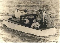
In 1937, President Franklin D. Roosevelt
visited Port Aransas and while Congress was debating his Judiciary Reorganization Bill of 1937
, he fished for tarpon. He hired Barney Farley, the famous fishing guide and brother of Fred Farley.
The president brought his own 35 feet (10.7 m) fishing boat and Barney Farley agreed to take the president out on the boat. After an unsuccessful outing, Barney Farley convinced the president to fish from a Farley Boat. The president caught so many tarpon that he returned to Port Aransas later that year to again fish with Barney Farley on a Farley Boat.
Today, there are Farley Boat planters located all over the city of Port Aransas celebrating the history and importance of the Farley Boat along the Gulf Coast.
(32°C
) with dewpoint temperatures in the middle to upper 70s, while average nighttime winter lows in January, the coldest month, are slightly less than 50 °F (10 °C).
, the city has a total area of 12.1 square miles (31.3 km²), of which, 8.8 square miles (22.8 km²) of it is land and 3.3 square miles (8.5 km²) of it (27.01%) is water. Port Aransas is located at 27°49′39"N 97°4′20"W (27.827373, -97.072205).
of 2000, there were 3,370 people, 1,542 households, and 993 families residing in the city. The population density
was 382.5 people per square mile (147.7/km²). There were 3,794 housing units at an average density of 430.6 per square mile (166.3/km²). The racial makeup of the city was 93.92% White, 0.42% African American, 1.25% Native American, 0.86% Asian, 0.03% Pacific Islander, 2.17% from other races
, and 1.36% from two or more races. Hispanic or Latino of any race were 6.08% of the population.
There were 1,542 households out of which 22.6% had children under the age of 18 living with them, 53.6% were married couples
living together, 7.3% had a female householder with no husband present, and 35.6% were non-families. 29.1% of all households were made up of individuals and 8.7% had someone living alone who was 65 years of age or older. The average household size was 2.18 and the average family size was 2.64.
In the city the population was 18.9% under the age of 18, 5.7% from 18 to 24, 25.2% from 25 to 44, 34.6% from 45 to 64, and 15.7% who were 65 years of age or older. The median age was 45 years. For every 100 females there were 108.4 males. For every 100 females age 18 and over, there were 106.6 males. The median income for a household in the city was $39,432, and the median income for a family was $46,719. Males had a median income of $28,000 versus $22,393 for females. The per capita income
for the city was $23,681. About 7.1% of families and 11.3% of the population were below the poverty line, including 17.4% of those under age 18 and 3.5% of those age 65 or over.
export. Fishing
has always been a staple, especially sport fishing for spotted seatrout
and redfish
. It is estimated that some 600+ species of saltwater fish inhabit the waters off Port Aransas. The fishing industry is still lively in the city, though local battles exist between RFA (Recreational Fishing Alliance) and CCA (Coastal Conservation Association.) Tourism is the largest section of the economy. The beach at Port Aransas draws thousands of visitors each weekend from Memorial Day
through Labor Day
.
The Port Aransas economy is increasingly focusing on eco-tourism. Bird-viewing locations have been established by the city and State of Texas agencies. Kayak paddling trails established by the State of Texas also contribute to eco-tourism. Port Aransas has begun the construction of a multi-acre Natural Preservation area that will provide hiking trails and other nature-related tourist activities.
. H.G. Olsen Elementary School, Brundrett Middle School, and Port Aransas High School serve the city.
Early history
Karankawa Indians played a key role in the early development of the TexasTexas
Texas is the second largest U.S. state by both area and population, and the largest state by area in the contiguous United States.The name, based on the Caddo word "Tejas" meaning "friends" or "allies", was applied by the Spanish to the Caddo themselves and to the region of their settlement in...
Gulf Coast. The Karankawa Indians inhabited the Gulf Coast of Texas
Texas
Texas is the second largest U.S. state by both area and population, and the largest state by area in the contiguous United States.The name, based on the Caddo word "Tejas" meaning "friends" or "allies", was applied by the Spanish to the Caddo themselves and to the region of their settlement in...
from Galveston Bay
Galveston Bay
Galveston Bay is a large estuary located along the upper coast of Texas in the United States. It is connected to the Gulf of Mexico and is surrounded by sub-tropic marshes and prairies on the mainland. The water in the Bay is a complex mixture of sea water and fresh water which supports a wide...
all the way to Corpus Christi Bay
Corpus Christi Bay
Corpus Christi Bay is a scenic semi-tropical bay on the Texas coast found in San Patricio and Nueces counties, next to the major city of Corpus Christi. It is separated from the Gulf of Mexico by Mustang Island, and is fed by the Nueces River and Oso Creek from its western and southern extensions,...
. The Karankawa Indians led a nomadic existence, migrating from the mainland to the coast. One of the places they lived in on the coast was a small fishing village known as "Sand Point" on what Europeans called "Wild Horse Island", later known as "Mustang Island
Mustang Island
Mustang Island is a barrier island on the Gulf Coast of Texas in the United States. The island is 18 miles long, stretching from Corpus Christi to Port Aransas. The island is oriented generally northeast-southwest, with the Gulf of Mexico on the east and south, and Corpus Christi Bay on the north...
".
They were living that nomadic existence when Spaniards, led by Alonso Álvarez de Pineda
Alonso Álvarez de Pineda
Alonso Álvarez de Pineda was a Spanish explorer and cartographer. His map marks the first document in Texas history.-Expedition:The Spanish thought there must be a sea lane from the Gulf of Mexico to Asia...
, probed the coast in 1519. Governor Francisco de Garay
Francisco de Garay
Francisco de Garay was a Spanish Basque conquistador. He was a companion to Christopher Columbus on his second voyage to the New World and arrived in Hispaniola in 1493. Here he attracted attention when he encountered a large gold nugget worth four thousand pesos.- Jamaica:From 1514 to 1523...
of Jamaica
Jamaica
Jamaica is an island nation of the Greater Antilles, in length, up to in width and 10,990 square kilometres in area. It is situated in the Caribbean Sea, about south of Cuba, and west of Hispaniola, the island harbouring the nation-states Haiti and the Dominican Republic...
had commissioned him to explore the Gulf Coast from Florida
Florida
Florida is a state in the southeastern United States, located on the nation's Atlantic and Gulf coasts. It is bordered to the west by the Gulf of Mexico, to the north by Alabama and Georgia and to the east by the Atlantic Ocean. With a population of 18,801,310 as measured by the 2010 census, it...
to Vera Cruz
Veracruz
Veracruz, formally Veracruz de Ignacio de la Llave officially Estado Libre y Soberano de Veracruz de Ignacio de la Llave , is one of the 31 states that, along with the Federal District, comprise the 32 federative entities of Mexico. It is divided in 212 municipalities and its capital city is...
. In the summer of 1519, Piñeda, took a fleet of four ships east to west around the Gulf Coast exploring and mapping five passes along the Texas Coast line, including what is known today as Aransas Pass
Aransas Pass
The second lighthouse in Texas was built at Aransas Pass by the United States government to protect shipping in Aransas Bay.Aransas Pass was originally pictured as becoming a major Texas hub of commerce and travel with rail links to the harbor and harbor links by ships to Mexico, New York and other...
.
In 1720 the French explorer Pierre-Jean de Béranger
Pierre-Jean de Béranger
Pierre-Jean de Béranger was a prolific French poet and chansonnier , who enjoyed great popularity and influence in France during his lifetime, but faded into obscurity in the decades following his death...
was commissioned to explore St. Bernard Bay 'Matagorda Bay' to establish a colony
Colony
In politics and history, a colony is a territory under the immediate political control of a state. For colonies in antiquity, city-states would often found their own colonies. Some colonies were historically countries, while others were territories without definite statehood from their inception....
for France
France
The French Republic , The French Republic , The French Republic , (commonly known as France , is a unitary semi-presidential republic in Western Europe with several overseas territories and islands located on other continents and in the Indian, Pacific, and Atlantic oceans. Metropolitan France...
along its shores. Jean took an old Spanish ship that had been captured in Florida during the war with Spain, christened it St. Joseph, and his travels resulted in the rediscovery of the Aransas Pass.
In 1739, Governor Prudencio de Orobio y Basterra named the pass Aránzazu Pass on his map of 1739, because it served the Aránzazu fort. The name was altered to Aransas on the map of a Captain Monroe of the ship Amos Wright in 1833.
Pirates of Port Aransas
Port Aransas was a location of pirates in the early 19th century. From about 1800 to the early 1820s, the Gulf Coast was a haunt of pirate ships searching for riches. Capt. Jean LafitteJean Lafitte
Jean Lafitte was a pirate and privateer in the Gulf of Mexico in the early 19th century. He and his elder brother, Pierre, spelled their last name Laffite, but English-language documents of the time used "Lafitte", and this is the commonly seen spelling in the United States, including for places...
and his buccaneers spent time on the Texas coast, Galveston owed its start to him and Mustang Island was one of his favorite haunts. Capt. Jean Lafitte
Jean Lafitte
Jean Lafitte was a pirate and privateer in the Gulf of Mexico in the early 19th century. He and his elder brother, Pierre, spelled their last name Laffite, but English-language documents of the time used "Lafitte", and this is the commonly seen spelling in the United States, including for places...
used Mustang Island as a place to make camp and, according to legend, a place to hide their treasure.
Local lore tells of pirate treasure buried in Port Aransas. The treasure chest
Treasure Chest
Treasure Chest was a Catholic-oriented comic book series created by Dayton, Ohio publisher George A...
is supposedly marked by a Spanish silver dagger
Dagger
A dagger is a fighting knife with a sharp point designed or capable of being used as a thrusting or stabbing weapon. The design dates to human prehistory, and daggers have been used throughout human experience to the modern day in close combat confrontations...
. It is believed the dagger is laid on its side with silver spike driven through the hilt, securing the location.
European settlement
By 1854, the Texas Senate
Texas Senate
The Texas Senate is the upper house of the Texas Legislature. There are 31 members of the Senate, representing 31 single-member districts across the state with populations of approximately 672,000 per constituency. There are no term limits, and each term is four years long. The Senate meets at the...
sanctioned a seven-mile (11 km) channel from Corpus Christi to the Aransas Pass bar to better serve the Port of Corpus Christ. Also in the 1850s, a regular steamship service route for cargo and passengers was established between New Orleans and Mustang Island. As the pass was brought into permanence, local pilot
Maritime pilot
A pilot is a mariner who guides ships through dangerous or congested waters, such as harbours or river mouths. With the exception of the Panama Canal, the pilot is only an advisor, as the captain remains in legal, overriding command of the vessel....
s were needed to guide the ships safely across the bar. For this, permanent structures were required to house the pilots, including docks, a lighthouse, storage, jetties, and a general store.
Life Saving Station and the Lighthouse
In 1850, the United States Life-Saving ServiceUnited States Life-Saving Service
The United States Life-Saving Service was a United States government agency that grew out of private and local humanitarian efforts to save the lives of shipwrecked mariners and passengers...
built the 8th District United States Life Saving Station in Port Aransas. The station was built for the aid and rescue of shipwrecked mariners and was manned by full-time crews. The Life Saving Station was administered by the United States Revenue Marine (later renamed the United States Revenue Cutter Service
United States Revenue Cutter Service
The United States Revenue Cutter Service was established by Secretary of the Treasury Alexander Hamilton in 1790 as an armed maritime law enforcement service. Throughout its entire existence the Revenue Cutter Service operated under the authority of the United States Department of the Treasury...
) and was run with a volunteer crew, much like a volunteer fire department
Volunteer fire department
See also the Firefighter article and its respective sections regarding VFDs in other countries.A volunteer fire department is a fire department composed of volunteers who perform fire suppression and other related emergency services for a local jurisdiction.The first organized force of...
.
United States Coast Guard
The United States Coast Guard is a branch of the United States Armed Forces and one of the seven U.S. uniformed services. The Coast Guard is a maritime, military, multi-mission service unique among the military branches for having a maritime law enforcement mission and a federal regulatory agency...
station stands on today. The Life Saving Station included a dock that stretched from the boathouse into the channel. The boats were hauled onto rails, and pushed into the boathouse when not in use. The small fleet of boats included: a 16 ft (4.9 m) skiff, a 24 ft (7.3 m) surf boat, a 26 ft (7.9 m) whale boat and a 27 ft (8.2 m) whale boat for rough surf
Breaking wave
In fluid dynamics, a breaking wave is a wave whose amplitude reaches a critical level at which some process can suddenly start to occur that causes large amounts of wave energy to be transformed into turbulent kinetic energy...
.
Designated keeper in charge of the 8th District Life Saving Station on Mustang Island
Mustang Island
Mustang Island is a barrier island on the Gulf Coast of Texas in the United States. The island is 18 miles long, stretching from Corpus Christi to Port Aransas. The island is oriented generally northeast-southwest, with the Gulf of Mexico on the east and south, and Corpus Christi Bay on the north...
was John G. Mercer. John Mercer, Robert's brother was also one of the local bar pilots, and was appointed sometime in September 1880.
After the announcement of a regular steamship service route between New Orleans and Port Aransas, the United States Congress
United States Congress
The United States Congress is the bicameral legislature of the federal government of the United States, consisting of the Senate and the House of Representatives. The Congress meets in the United States Capitol in Washington, D.C....
commissioned $12,500 for the construction of the Aransas Pass Lighthouse. Haggling over lighthouse's specifications mired down the process and another survey was done. Meanwhile, the pass slowly moved south as currents deposited sand on its north bank at the south end of Saint Joseph Island. It was then advised that a lightship be used to mark the pass. More surveying was done, more talk and then a proposition was accepted to erect a screw-pile lighthouse of brick.
In December 1855, the ship transporting the bricks struck, and then stuck, on the bar. The crew mates were all rescued but the ship and its cargo went to the bottom of the sea. New bricks arrived in 1856, soon followed by the lantern room that would be set on top, and lastly a fourth-order Fresnel lens
Fresnel lens
A Fresnel lens is a type of lens originally developed by French physicist Augustin-Jean Fresnel for lighthouses.The design allows the construction of lenses of large aperture and short focal length without the mass and volume of material that would be required by a lens of conventional design...
. There was also need of a lighthouse keeper's dwelling, a small storage room and docks. The construction would be complete by mid 1857 and the light guided ships through the pass later that year.
The Lydia Ann Channel Lighthouse was deactivated in 1952 after a major channel shift left the station a mile from the channel entrance. To better mark Aransas Pass, a new light was established in 1952 at the Port Aransas Coast Guard Station, and the Aransas Pass Lighthouse was deactivated, just a few years shy of a century of service.
The Civil War
Around the start of the American Civil WarAmerican Civil War
The American Civil War was a civil war fought in the United States of America. In response to the election of Abraham Lincoln as President of the United States, 11 southern slave states declared their secession from the United States and formed the Confederate States of America ; the other 25...
, the lens was taken out of the lantern room of the lighthouse and hidden in the marsh
Marsh
In geography, a marsh, or morass, is a type of wetland that is subject to frequent or continuous flood. Typically the water is shallow and features grasses, rushes, reeds, typhas, sedges, other herbaceous plants, and moss....
lands behind the structure. This lighthouse was of utmost importance because it controlled the nighttime pass; whoever governed the light beacon regulated the night time passageway. Without that light, the Union ships could only traverse the treacherous pass in the daytime, limiting Union ship movement in the blockade of the coastline.
The harbors in the Corpus Christi
Corpus Christi, Texas
Corpus Christi is a coastal city in the South Texas region of the U.S. state of Texas. The county seat of Nueces County, it also extends into Aransas, Kleberg, and San Patricio counties. The MSA population in 2008 was 416,376. The population was 305,215 at the 2010 census making it the...
, Rockport
Rockport, Texas
Rockport is a city in Aransas County, Texas, United States. The population was 7,385 at the 2000 census. It is the county seat of Aransas County. The coastal community has approximately 8000 citizens. Large windswept live oaks are a dominating feature of the area and the state's oldest live oak,...
-St. Marys, Copano Bay
Copano Bay
Copano Bay is a northwestern extension of Aransas Bay, west of Rockport, Texas in Refugio and Aransas counties. It is supplied with seawater from the Gulf of Mexico via Aransas Bay, and fed freshwater from the Aransas River, Mission River and Copano Creek...
area and Mustang
Mustang Island
Mustang Island is a barrier island on the Gulf Coast of Texas in the United States. The island is 18 miles long, stretching from Corpus Christi to Port Aransas. The island is oriented generally northeast-southwest, with the Gulf of Mexico on the east and south, and Corpus Christi Bay on the north...
and San Jose islands were all supplying the Confederate Army with beef, salt, seafood and cotton supplies for the troops fighting the North, and the Union was bent on stopping those shipments. Around November 1861, as expected the Union Navy started a campaign of coastal blockade
Blockade
A blockade is an effort to cut off food, supplies, war material or communications from a particular area by force, either in part or totally. A blockade should not be confused with an embargo or sanctions, which are legal barriers to trade, and is distinct from a siege in that a blockade is usually...
. Then, Marines
United States Marine Corps
The United States Marine Corps is a branch of the United States Armed Forces responsible for providing power projection from the sea, using the mobility of the United States Navy to deliver combined-arms task forces rapidly. It is one of seven uniformed services of the United States...
off the Navy vessel USS Afton surged ashore on San Jose Island and leveled the small town of Aransas, burning most of the houses, structures, warehouses, piers, docks and wharf sometime in February 1862. The small town was all but wiped out, but remnants of it can still be found today. Jurisdiction of the lighthouse traded back and forth between the Confederate and Union detachments throughout the war.
Though Lt. J. W. Kittredge attempted the expropriation of Corpus Christi from the Southern forces, Maj. Alfred M. Hobby and troops sent the Union ships sailing away. By early that summer, southern civilians had forsaken the islands rather than be under the rule of the North. United States Navy
United States Navy
The United States Navy is the naval warfare service branch of the United States Armed Forces and one of the seven uniformed services of the United States. The U.S. Navy is the largest in the world; its battle fleet tonnage is greater than that of the next 13 largest navies combined. The U.S...
vessels under J. W. Kittredge (before he was captured) besieged the coast, using St. Joseph's Island and the few remaining structures on it as a depot to store captured cotton.
On Christmas Day of 1862 a move was made by Confederate General John B. Magruder
John B. Magruder
John Bankhead Magruder was a career military officer who served in the armies of three nations. He was a U.S. Army officer in the Mexican-American War, a Confederate general during the American Civil War, and a postbellum general in the Imperial Mexican Army...
, who authored a detachment of troops to commence the ruination of the lighthouse tower. Gunpowder
Gunpowder
Gunpowder, also known since in the late 19th century as black powder, was the first chemical explosive and the only one known until the mid 1800s. It is a mixture of sulfur, charcoal, and potassium nitrate - with the sulfur and charcoal acting as fuels, while the saltpeter works as an oxidizer...
kegs were clustered inside the tower and lit, resulting in the damaging of 20–25 feet of brickwork, the glass housing case and the round stairwell.
The next significant stage in the war for this arena was on May 3, 1863, when Capt. Edwin E. Hobby's Confederate company assaulted the Union garrison set to protect the lighthouse and killed twenty soldiers. On the May 8, the Confederates once again maintained a battery on Mustang Island; later in the month, they pushed Union forces off St. Joseph's Island. But their victory would not be long-lived as the Union comprehended the significance of the pass, and in November federal troops under T. C. G. Robinson came back and regained control of the island.
The Tarpon Inn
Tarpon Inn
The Tarpon Inn is a historic hotel located in Port Aransas, Texas, United States that originally opened in 1886. The building was named after the tarpon sport fish that drew many anglers to the sea side city and Port Aransas was called Tarpon at the time...
. It was opened by Frank Stephenson and sold to Mary Hatfield and her son, Ed Cotter in 1897. After the 1919 hurricane
1919 Florida Keys Hurricane
The Florida Keys Hurricane or Atlantic Gulf Hurricane of 1919 was an intense Atlantic hurricane, killing 772 people as it moved through the Florida Keys and Texas. The second tropical cyclone of the 1919 hurricane season, it moved in the proximity of the eastern Greater Antilles and Bahamas...
destroyed the main structure, the inn was sold again in 1923 to James M. Ellis, who rebuilt the inn to resemble the old barracks.
When the Tarpon Inn was rebuilt in 1923, many of the new pilings were placed in concrete, with the ends extending up through the entire structure and into the attic. Because the Tarpon Inn was built with impressive reinforcements and a protected shelter, it has housed many residents during storms and has served as headquarters for the Red Cross, the Salvation Army
Salvation Army
The Salvation Army is a Protestant Christian church known for its thrift stores and charity work. It is an international movement that currently works in over a hundred countries....
, and military units.
Two of the walls of the Tarpon Inn are covered with tarpon
Tarpon
Tarpons are large fish of the genus Megalops. There are two species of Megalops, one native to the Atlantic, and the other to the Indo-Pacific oceans.They are the only members of the family Megalopidae.- Species and habitats :...
scales. Each of the scales has the signature and hometown of the angler who caught the tarpon as well as the size, weight and date of the catch. Some of the people who have stayed at the Tarpon Inn include: President Franklin D. Roosevelt
Franklin D. Roosevelt
Franklin Delano Roosevelt , also known by his initials, FDR, was the 32nd President of the United States and a central figure in world events during the mid-20th century, leading the United States during a time of worldwide economic crisis and world war...
, who fished there in 1937; Duncan Hines
Duncan Hines
Duncan Hines was an American pioneer of restaurant ratings for travelers. He is best known today for the brand of food products that bears his name.-History:...
, who spent his honeymoon
Honeymoon
-History:One early reference to a honeymoon is in Deuteronomy 24:5 “When a man is newly wed, he need not go out on a military expedition, nor shall any public duty be imposed on him...
there; Hedy Lamarr
Hedy Lamarr
Hedy Lamarr was an Austrian-American actress celebrated for her great beauty who was a major contract star of MGM's "Golden Age".Lamarr also co-invented – with composer George Antheil – an early technique for spread spectrum communications and frequency hopping, necessary to wireless...
; Victor McLaglen
Victor McLaglen
Victor Andrew de Bier Everleigh McLaglen was an English boxer and World War I veteran who became a successful film actor.Towards the end of his life he was naturalised as a U.S. citizen.-Early life:...
; Aimee Semple McPherson
Aimee Semple McPherson
Aimee Semple McPherson , also known as Sister Aimee, was a Canadian-American Los Angeles, California evangelist and media celebrity in the 1920s and 1930s. She founded the Foursquare Church...
; Clyde Beatty
Clyde Beatty
Clyde Beatty joined the circus as a cage cleaner as a teen and became famous as a lion tamer and animal trainer. He also became a circus impresario who owned his own show that later merged with the Cole Bros. Circus to form the Clyde Beatty-Cole Bros...
; Bob Lilly
Bob Lilly
Robert Lewis Lilly is a former American football defensive tackle in the National Football League and photographer. He was inducted into the Pro Football Hall of Fame in 1980.-College career:...
; and physicist Edward Teller
Edward Teller
Edward Teller was a Hungarian-American theoretical physicist, known colloquially as "the father of the hydrogen bomb," even though he did not care for the title. Teller made numerous contributions to nuclear and molecular physics, spectroscopy , and surface physics...
.
In 1979, the Tarpon Inn was listed on the National Register of Historic Places
National Register of Historic Places
The National Register of Historic Places is the United States government's official list of districts, sites, buildings, structures, and objects deemed worthy of preservation...
and was recognized as a Texas Historic Landmark.
Ropesville
Elihu Harrison Ropes, while visiting Galveston IslandGalveston Island
Galveston Island is a barrier island on the Texas Gulf coast in the United States, about 50 miles southeast of Houston. The entire island, with the exception of Jamaica Beach, is within the city limits of the City of Galveston....
in 1887 saw the possibility of the development of a deep water port on the Texas coast, and looked to Corpus Christi
Corpus Christi, Texas
Corpus Christi is a coastal city in the South Texas region of the U.S. state of Texas. The county seat of Nueces County, it also extends into Aransas, Kleberg, and San Patricio counties. The MSA population in 2008 was 416,376. The population was 305,215 at the 2010 census making it the...
as the state's first much needed deep-vessel port of call. After exploring Mustang Island, Ropes proclaimed a plan to excavate a channel through the island. To complete the venture, Ropes founded the Port Ropes Company. Mr. Ropes paid $25,000 for Mustang Island
Mustang Island
Mustang Island is a barrier island on the Gulf Coast of Texas in the United States. The island is 18 miles long, stretching from Corpus Christi to Port Aransas. The island is oriented generally northeast-southwest, with the Gulf of Mexico on the east and south, and Corpus Christi Bay on the north...
and purchased a dredge to dig the channel. In June 1890 Mr. Ropes launched the fruitless project to build a channel across the island to give the port of Corpus Christi a direct connection with the deep water of the Gulf of Mexico. By the end of 1891, however, the project was terminated due to many problems.
In 1888 the town's first official post office was established under the name Ropesville. This first official name of what is now Port Aransas, did not last for long.
In 1890 the Aransas Pass & Harbor Company, under government contracts, launched a plan to deepen the channel through the pass and over the sandbar. The plan called for the construction of two brand new jetties but the plan failed to increase the depth of the channel. Another plan was put into action, calling for the blasting of the channel with thousands of pounds of dynamite, but this also failed. The newest jetties, and shallow draft would have to stay as they were for the time being.
In 1896 the name was changed to Tarpon because of the abundant game fish that filled the waters around it. The population at that time was about 250. The Rivers and Harbors Act of 1899
Rivers and Harbors Act of 1899
The Rivers and Harbors Appropriation Act of 1899 is the oldest federal environmental law in the United States. The Act makes it a misdemeanor to discharge refuse matter of any kind into the navigable waters, or tributaries thereof, of the United States without a permit; this specific provision is...
called for the elimination of the old Mansfield jetty "south jetty". The project was finished by 1911 while this was still going on, and after several private and government endeavors couldn't to get a deep-water pass between Mustang and St. Joseph islands, the United States Army Corps of Engineers
United States Army Corps of Engineers
The United States Army Corps of Engineers is a federal agency and a major Army command made up of some 38,000 civilian and military personnel, making it the world's largest public engineering, design and construction management agency...
took over the project in 1907, and was granted the right to build a new south "Nelson" jetty and to unite the "Haupt jetty" to St. Joseph Island that same year.
1916 Texas Hurricane
1916 Texas Hurricane
The 1916 Texas Hurricane was a Category 4 hurricane that struck the southern Texas coast in mid August 1916. The hurricane was the fourth hurricane and third major hurricane of an active 1916 Atlantic hurricane season. Forming on August 12, the storm crossed the Leeward Islands and Caribbean Sea...
destroyed Port Aransas except for a few buildings. The docks, wharf and warehouses were now on the mainland and the island was flooded and infested with rattlesnakes. The destruction of the 1916 Texas Hurricane did not discourage the people of Port Aransas for very long. The Tarpon Inn was rebuilt and, the docks, wharves, and warehouses were replaced. After the city was rebuilt, it became a destination for anglers, tourists, surfers, and vacationers.
Transportation to and from Port Aransas
A United States CensusUnited States Census
The United States Census is a decennial census mandated by the United States Constitution. The population is enumerated every 10 years and the results are used to allocate Congressional seats , electoral votes, and government program funding. The United States Census Bureau The United States Census...
taken in 1925 showed 250 people living on the Island, and a population of 300 by 1931. A toll road was opened in 1931 between the town of Aransas Pass
Aransas Pass
The second lighthouse in Texas was built at Aransas Pass by the United States government to protect shipping in Aransas Bay.Aransas Pass was originally pictured as becoming a major Texas hub of commerce and travel with rail links to the harbor and harbor links by ships to Mexico, New York and other...
and the ferry landing of Port Aransas. Before the toll road, a driver bought bought a ticket, loaded their vehicle onto a flatbed or train, and used the wooden planks inside the rails when the train was not on a scheduled run. With the advent of the toll road, drivers could simply pay a toll and drive on a wooded plank structure built next to the rail tracks. After the railroad closed in 1947, it was used only to transport automobiles until 1960, when the state built a modern road to Harbor Island
Harbor Island
Harbor Island is an artificial island in the mouth of Seattle, Washington's Duwamish Waterway where it empties into Elliott Bay. Built by the Puget Sound Bridge and Dredging Company, Harbor Island was completed in 1909 and was then the largest artificial island in the world, at 350 acres...
from Corpus Christi and the ferry landing.
Today, the Port Aransas Ferry System provides free transportation service seven days a week, twenty-four hours a day. The ferry ride connects Mustang Island and Port Aransas with the mainland via Harbor Island and Aransas Pass
Aransas Pass
The second lighthouse in Texas was built at Aransas Pass by the United States government to protect shipping in Aransas Bay.Aransas Pass was originally pictured as becoming a major Texas hub of commerce and travel with rail links to the harbor and harbor links by ships to Mexico, New York and other...
. There are eight large ferry boats that can carry 20 to 28 regular passenger vehicles on each trip. Each boat can move 100 vehicles per hour.
The University of Texas Marine Science Institute
In 1935 Dr. E.J. Lund, a zoologist from The University of Texas, traveled to Port Aransas to investigate a massive fish kill. He constructed a small rough lumber one-room shack on the old Corps of Engineers dock. Dr. Lund recognized the value of the local environment and the need for public education about the natural resources of the Gulf of Mexico and gradually rekindled interest in marine science at the university.In 1941 The University of Texas Marine Science Institute was formed with Dr. Lund as the first Director. Research began in the old pier building with one of the first projects being on the distribution, life history and abundance of marine fishes of Texas, by Dr. Lund and Dr. Gordon Gunter, who was Lund’s student and later followed Lund as Director. Gunter also undertook a study for the U.S. Navy on the problem of fouling on ships’ bottoms.
With the end of the war, development of the Institute resumed. Lund purchased and donated 12 acres (48,562.3 m²). The old Army Corps of Engineers building, constructed in 1890 and veteran of several hurricanes, was included. This building is still there today and serves as a dormitory
Dormitory
A dormitory, often shortened to dorm, in the United States is a residence hall consisting of sleeping quarters or entire buildings primarily providing sleeping and residential quarters for large numbers of people, often boarding school, college or university students...
where students relax on an old fashioned porch and watch ships and porpoises almost at the doorstep on the Aransas Pass.
In 1946 the first permanent marine laboratory was established in Port Aransas, Texas. Two frame buildings were constructed, which still serve as the cafeteria and a dormitory, and a full time staff was in residence. A laboratory was built on the pier in 1948 and major expansion of physical facilities took place in the 1970s with the acquisition of 49 acres (198,296.1 m²) of land, additional laboratories, dormitory, apartments, maintenance complex and a 5¼ acre boat basin.
Port Aransas during World War II
During World War IIWorld War II
World War II, or the Second World War , was a global conflict lasting from 1939 to 1945, involving most of the world's nations—including all of the great powers—eventually forming two opposing military alliances: the Allies and the Axis...
, an artillery gun turret
Gun turret
A gun turret is a weapon mount that protects the crew or mechanism of a projectile-firing weapon and at the same time lets the weapon be aimed and fired in many directions.The turret is also a rotating weapon platform...
was erected by the United States Army
United States Army
The United States Army is the main branch of the United States Armed Forces responsible for land-based military operations. It is the largest and oldest established branch of the U.S. military, and is one of seven U.S. uniformed services...
and maintained throughout the war, on a high dune just off Cotter St. across from the UT campus, and is now part of the UT properties. It was placed to protect the pass from sightings of German U-boats. Blackouts
Rolling blackout
A rolling blackout, also referred to as load shedding, is an intentionally-engineered electrical power outage where electricity delivery is stopped for non-overlapping periods of time over geographical regions. Rolling blackouts are a last-resort measure used by an electric utility company in order...
were called on all the island during nighttime hours, no fires on the beach or car lights, and house windows could not show light and had to be covered with heavy curtains, blankets or wood.
The Farley Boat and Port Aransas
To meet the needs of anglers coming from across the country to fish for tarpon, the Farley Family began building the Farley boat. In 1915, Charles Frederick Farley and his son established Farley and Son, Boat Builders in Port Aransas.
The Farley boats were designed to meet the needs of anglers and fishing guides. They were designed with low-sides and a high bow to fight the choppy waves. The Farley Boats were also designed with low cabins that allowed fishing in every direction.
In 1937, President Franklin D. Roosevelt
Franklin D. Roosevelt
Franklin Delano Roosevelt , also known by his initials, FDR, was the 32nd President of the United States and a central figure in world events during the mid-20th century, leading the United States during a time of worldwide economic crisis and world war...
visited Port Aransas and while Congress was debating his Judiciary Reorganization Bill of 1937
Judiciary Reorganization Bill of 1937
The Judicial Procedures Reform Bill of 1937, frequently called the court-packing plan, was a legislative initiative proposed by U.S. President Franklin Roosevelt to add more justices to the U.S. Supreme Court. Roosevelt's purpose was to obtain favorable rulings regarding New Deal legislation that...
, he fished for tarpon. He hired Barney Farley, the famous fishing guide and brother of Fred Farley.
The president brought his own 35 feet (10.7 m) fishing boat and Barney Farley agreed to take the president out on the boat. After an unsuccessful outing, Barney Farley convinced the president to fish from a Farley Boat. The president caught so many tarpon that he returned to Port Aransas later that year to again fish with Barney Farley on a Farley Boat.
Today, there are Farley Boat planters located all over the city of Port Aransas celebrating the history and importance of the Farley Boat along the Gulf Coast.
Modern-day Port Aransas
Port Aransas has now become a fishing, beach, and resort village, with summer populations sometimes swelling to 60,000 or more, as well as a college spring-break destination.Weather
Port Aransas experiences a humid subtropical climate, enjoying similar temperatures to those of other Gulf Coast regions, such as Deep South Texas and Southern Florida. The area experiences an average annual rainfall of 31.92 inches (810.8 mm), with prevailing winds out of the southeast from the Gulf of Mexico. Average high temperatures in the summer months exceed 90°FFahrenheit
Fahrenheit is the temperature scale proposed in 1724 by, and named after, the German physicist Daniel Gabriel Fahrenheit . Within this scale, the freezing of water into ice is defined at 32 degrees, while the boiling point of water is defined to be 212 degrees...
(32°C
Celsius
Celsius is a scale and unit of measurement for temperature. It is named after the Swedish astronomer Anders Celsius , who developed a similar temperature scale two years before his death...
) with dewpoint temperatures in the middle to upper 70s, while average nighttime winter lows in January, the coldest month, are slightly less than 50 °F (10 °C).
| Monthly normal and record high and low temperatures | ||||||||||||
| Month | Jan | Feb | Mar | Apr | May | Jun | Jul | Aug | Sep | Oct | Nov | Dec |
|---|---|---|---|---|---|---|---|---|---|---|---|---|
| Rec High °F | 91 | 98 | 102 | 102 | 103 | 106 | 104 | 104 | 109 | 98 | 98 | 91 |
| Norm High °F | 66 | 69.7 | 75.8 | 80.7 | 85.6 | 90.2 | 93.2 | 93.4 | 89.9 | 83.6 | 74.9 | 68 |
| Norm Low °F | 46.2 | 49.3 | 56.2 | 62.3 | 69.5 | 73.5 | 74.4 | 74.5 | 71.6 | 64 | 55.4 | 48.1 |
| Rec Low °F | 14 | 18 | 24 | 33 | 47 | 58 | 64 | 64 | 50 | 28 | 28 | 13 |
| Precip (in) | 1.62 | 1.84 | 1.74 | 2.05 | 3.48 | 3.53 | 2 | 3.54 | 5.03 | 3.94 | 1.74 | 1.75 |
| Source: USTravelWeather.com http://www.portaransas.org/weather.html | ||||||||||||
Geography
According to the United States Census BureauUnited States Census Bureau
The United States Census Bureau is the government agency that is responsible for the United States Census. It also gathers other national demographic and economic data...
, the city has a total area of 12.1 square miles (31.3 km²), of which, 8.8 square miles (22.8 km²) of it is land and 3.3 square miles (8.5 km²) of it (27.01%) is water. Port Aransas is located at 27°49′39"N 97°4′20"W (27.827373, -97.072205).
Demographics
As of the censusCensus
A census is the procedure of systematically acquiring and recording information about the members of a given population. It is a regularly occurring and official count of a particular population. The term is used mostly in connection with national population and housing censuses; other common...
of 2000, there were 3,370 people, 1,542 households, and 993 families residing in the city. The population density
Population density
Population density is a measurement of population per unit area or unit volume. It is frequently applied to living organisms, and particularly to humans...
was 382.5 people per square mile (147.7/km²). There were 3,794 housing units at an average density of 430.6 per square mile (166.3/km²). The racial makeup of the city was 93.92% White, 0.42% African American, 1.25% Native American, 0.86% Asian, 0.03% Pacific Islander, 2.17% from other races
Race (United States Census)
Race and ethnicity in the United States Census, as defined by the Federal Office of Management and Budget and the United States Census Bureau, are self-identification data items in which residents choose the race or races with which they most closely identify, and indicate whether or not they are...
, and 1.36% from two or more races. Hispanic or Latino of any race were 6.08% of the population.
There were 1,542 households out of which 22.6% had children under the age of 18 living with them, 53.6% were married couples
Marriage
Marriage is a social union or legal contract between people that creates kinship. It is an institution in which interpersonal relationships, usually intimate and sexual, are acknowledged in a variety of ways, depending on the culture or subculture in which it is found...
living together, 7.3% had a female householder with no husband present, and 35.6% were non-families. 29.1% of all households were made up of individuals and 8.7% had someone living alone who was 65 years of age or older. The average household size was 2.18 and the average family size was 2.64.
In the city the population was 18.9% under the age of 18, 5.7% from 18 to 24, 25.2% from 25 to 44, 34.6% from 45 to 64, and 15.7% who were 65 years of age or older. The median age was 45 years. For every 100 females there were 108.4 males. For every 100 females age 18 and over, there were 106.6 males. The median income for a household in the city was $39,432, and the median income for a family was $46,719. Males had a median income of $28,000 versus $22,393 for females. The per capita income
Per capita income
Per capita income or income per person is a measure of mean income within an economic aggregate, such as a country or city. It is calculated by taking a measure of all sources of income in the aggregate and dividing it by the total population...
for the city was $23,681. About 7.1% of families and 11.3% of the population were below the poverty line, including 17.4% of those under age 18 and 3.5% of those age 65 or over.
Economy
Around 1900, the village was doing big business in sea turtleSea turtle
Sea turtles are marine reptiles that inhabit all of the world's oceans except the Arctic.-Distribution:...
export. Fishing
Fishing
Fishing is the activity of trying to catch wild fish. Fish are normally caught in the wild. Techniques for catching fish include hand gathering, spearing, netting, angling and trapping....
has always been a staple, especially sport fishing for spotted seatrout
Trout
Trout is the name for a number of species of freshwater and saltwater fish belonging to the Salmoninae subfamily of the family Salmonidae. Salmon belong to the same family as trout. Most salmon species spend almost all their lives in salt water...
and redfish
Redfish
Redfish is a common name for several species of fish. It is most commonly applied to members of the deep-sea genus Sebastes, or the reef dwelling snappers, Lutjanus. It is also applied to the slimeheads or roughies , and the alfonsinos ....
. It is estimated that some 600+ species of saltwater fish inhabit the waters off Port Aransas. The fishing industry is still lively in the city, though local battles exist between RFA (Recreational Fishing Alliance) and CCA (Coastal Conservation Association.) Tourism is the largest section of the economy. The beach at Port Aransas draws thousands of visitors each weekend from Memorial Day
Memorial Day
Memorial Day is a United States federal holiday observed on the last Monday of May. Formerly known as Decoration Day, it originated after the American Civil War to commemorate the fallen Union soldiers of the Civil War...
through Labor Day
Labor Day
Labor Day is a United States federal holiday observed on the first Monday in September that celebrates the economic and social contributions of workers.-History:...
.
The Port Aransas economy is increasingly focusing on eco-tourism. Bird-viewing locations have been established by the city and State of Texas agencies. Kayak paddling trails established by the State of Texas also contribute to eco-tourism. Port Aransas has begun the construction of a multi-acre Natural Preservation area that will provide hiking trails and other nature-related tourist activities.
Education
Port Aransas' public schools are operated by the Port Aransas Independent School DistrictPort Aransas Independent School District
Port Aransas Independent School District is a public school district based in Port Aransas, Texas .Located in Nueces County, a small portion of the district extends into Aransas County....
. H.G. Olsen Elementary School, Brundrett Middle School, and Port Aransas High School serve the city.