

Hawaii State Highway 200
Encyclopedia
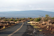
Route 200, known locally as Saddle Road, traverses the width of the Island of Hawaii
, from downtown
Hilo to its junction with Hawaii Route 190 near Waimea. The road was considered one of the most dangerous paved roads in the state, with many one-lane bridges and areas of marginally maintained pavement. Most of the road has now been repaved, and major parts have new re-alignments to modern standards. The highway reaches a maximum elevation of 6632 feet (2,021.4 m) and is subject to fog and low visibility. Many rental car companies used to prohibit use of their cars on Saddle Road, but some now permit use of the road. The highway experiences heavy use as it provides the shortest driving route from Hilo to Kailua-Kona and access to the slopes of Mauna Loa
and the Mauna Kea Observatories.
proposed building a road directly between the two population centers of the Island of Hawaii
. Using prison labor, it started near Holualoa Bay
at 19°35′57"N 155°58′26"W and proceeded in a straight line up to the plateau south of Hualālai
. After ten years only about 12 miles (19.3 km) were completed, when work was abandoned at 19°38′38"N 155°45′12"W when the 1859 eruption of Mauna Loa
blocked its path.
Although destroyed at lower elevations due to residential development, it can still be seen on maps as the "Judd Trail".
While planning for the defense of the Hawaiian islands
in the wake of the attack on Pearl Harbor
, the U. S. Army hastily built an access road in 1943 across the Humuula plateau of Parker Ranch
at 19°41′44"N 155°29′8"W. Since it was not intended as a civilian
road, the simple gravel path was built by the Civilian Conservation Corps
and the US Army Corps of Engineers in case of an invasion. Military vehicle
s of all types and tread
s traversed the Island for the next three years.
Following the end of World War II
in 1945, the Army turned over jurisdiction
of the road to the Territory of Hawaii
and it was designated "State Route 20." However, the territorial government had few funds to maintain the road, let alone upgrade it to civilian standards. Much of the paving dates from 1949.
About the same time, Tom Vance, who had earlier supervised building a highway up Mauna Loa named for Governor Ingram Stainback
, secretly used his prison laborers to start a more direct Hilo-Kona road. He started at a camp 19°38′12"N 155°28′52"W (still called "Vance" on USGS maps) which was exactly midway between Hilo and Kealakekua. The road extended in a straight line, heading for the pass between Hualālai and Mauna Loa.
In 1950, the camp caught fire after construction reached 19°37′17"N 155°35′57"W. The public refused to allocate more funding when they discovered about US$1 million had already been spent, so the project was also abandoned.
After islands became the State of Hawaii
in 1959, Saddle Road was handed to the County of Hawaii and for many years only minimal maintenance was performed, leading to generally poor conditions and the source of the road's notorious reputation.
Since 1992 there has been increased attention on the road, with efforts to rebuild and renovate the highway into a practical cross-island route. This resulted in repaving some sections and complete rebuilding of others.
0 is posted in Hilo on the traffic signal at the intersection
of Waiānenue Avenue, Kamehameha Avenue and Bayfront Highway at coordinates 19°43′36"N 155°5′12"W. The route continues mauka along Waiānuenue Avenue to a little over a half-mile past the mile 1 where it veers left onto Kaūmana Drive near Gilbert Carvalho Park. Further along Waiānuenue Avenue is Rainbow Falls Park
(Waiānuenue means "rainbow" in the Hawaiian language
).
s and open drainage ditch
es. Near mile 4 it passes Kaumana Cave, a lava tube. Just past mile 6 (coordinates 19°40′51"N 155°9′23"W) is the junction with Pūāinakō Street Extension, (Hawaii Route 2000), completed in September 2004 as a bypass
of the above-mentioned windy sections. The intersection with Ua Nahele Street at mile 8 marks the mauka terminus of Kaūmana Drive.
and Mauna Loa
. The rainforest of the Hilo Forest Reserve and Upper Waiākea Forest Reserve surround the roadway and begin to thin as the elevation
increases. Quality of the asphalt
surface is quite good on this side of the crest
but there are many curves and rises with limited visual distances.
Reconstruction of the sections from mileposts 11 to 19 and 19 to 28 was finished in November 2011 and October 2008, respectively.
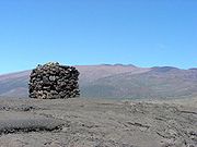
The terrain becomes the high lava desert of the Humuula Saddle. Two roads intersect Saddle Road close to Puu Huluhulu at its crest near mile 28 at 6,632 feet (2,021 m) above sea level
:
 Mauna Loa Observatory Road is an unmarked 17.1 mile (27.5km) long narrow rough (but paved) road which winds its way towards Mauna Loa Solar Observatory
, Mauna Loa Atmospheric Observatory
, and AMiBA
on the slopes of Mauna Loa
. It was connected in 1963 to the old Tom Vance road from 1950.
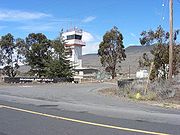
Mauna Kea Summit Road (known as John A. Burns
Way) provides access to the Onizuka Center for International Astronomy
(at elevation
9,300 ft / 2,835m) then climbs Mauna Kea
past the Mauna Kea Ice Age Reserve
to the height of 13,780 ft (4,200m) at grades averaging 17% making this the third highest public road in the United States
. The road is 14 miles (22.5 km) long, of which the first 6 miles (to the Onizuka Center) and the last 3 miles (4.8 km) are paved. Puu Wēkiu is the highest point in Hawaii at 13,796 ft (4,208m) and is home to Poliahu
, Goddess
of Snow
. Mauna Kea Observatory
on the summit, an ideal location for astronomical seeing
, is under the jurisdiction of the University of Hawaii
Institute for Astronomy
. Driving from sea level to the top of Mauna Kea Summit Road provides the greatest elevation gain possible by car in one state.

 The 6.5 miles (10.5 km) segment from milepost 28 to 35 was dedicated and opened to traffic on May 29, 2007 with Senator Daniel K. Inouye as the keynote speaker and other local dignitaries. The new segment is quite a contrast to the roadway it near the Pōhakuloa Training Area
. The old section of roadway included some of the more dangerous features of the old Saddle Road: a sharp curve, blind corner and one way bridge near the entrance to Mauna Kea State Recreation Area
that was one of the worst on the roadway. In contrast the new section was constructed to full federal highway standards
, with wide shoulders, rumble strips, good signage and emergency phones at regular intervals.
From milepost 35 to 44 the road passes the main gates of Pōhakuloa Training Area and Bradshaw Army Airfield before continuing across the military reservation. Military vehicles — including armored personnel carriers
— occasionally cross or occupy the roadway. Artillery
exercises, including live fire, are not uncommon with batteries set up along the roadway firing towards Mauna Loa. This section of the road was repaved in the summer of 2008, greatly improving the conditions.
On August 18, 2009 the completely rebuilt section, from milepost 35 to 42, opened to public travel. The realignment relocated the highway north to the Mauna Kea side of the Army base and Bradshaw Army Airfield.
From milepost 44, near Kilohana, to the Māmalahoa Highway the road retains its original character, a narrow ribbon of poorly maintained pavement
with crumbling edges. There are several more one lane bridges, blind curves and hills. It is common for drivers to negotiate the center of the road to avoid the rough shoulders, moving back into the lane only when necessary to pass traffic proceeding in the opposite direction. The route is quite scenic with views of the coastline, the Hualālai
and Kohala
volcanoes, winding its way across Parker Ranch
and through the development of Waikii.
The original western terminus of Route 200 comes at its junction with Māmalahoa Highway (state route 190) six miles (9.6km) toward Kona
of Waimea (coordinates 19°50′47"N 155°44′27"W).
Eventual plans are to complete a section past Māmalahoa Highway down to the coast and intersecting the Queen Kaahumanu Highway (state route 19) to support cross-island commuting by tourists and resort employees. The route for the entirely new sections of the highway was changed after the 2006 expansion of the military exercise areas. Completion of these projects represent a major realignment of island traffic patterns and conversion of this notorious roadway into a modern state highway.
, in the state of Hawaii
. The road's western terminus is at Hawaii Route 200 (known as the Saddle Road). The eastern terminus is at Hawaii Route 11 (known as the Hawaii Belt Road) in Hilo where the Prince Kūhiō Plaza
shopping center is located. Route 2000 is called Pūāinakō Street Extension, East Pūāinakō Street, and West Pūāinakō Street. The project was planned since 1995.
Hawaii (island)
The Island of Hawaii, also called the Big Island or Hawaii Island , is a volcanic island in the North Pacific Ocean...
, from downtown
Downtown
Downtown is a term primarily used in North America by English speakers to refer to a city's core or central business district ....
Hilo to its junction with Hawaii Route 190 near Waimea. The road was considered one of the most dangerous paved roads in the state, with many one-lane bridges and areas of marginally maintained pavement. Most of the road has now been repaved, and major parts have new re-alignments to modern standards. The highway reaches a maximum elevation of 6632 feet (2,021.4 m) and is subject to fog and low visibility. Many rental car companies used to prohibit use of their cars on Saddle Road, but some now permit use of the road. The highway experiences heavy use as it provides the shortest driving route from Hilo to Kailua-Kona and access to the slopes of Mauna Loa
Mauna Loa
Mauna Loa is one of five volcanoes that form the Island of Hawaii in the U.S. state of Hawaii in the Pacific Ocean, and the largest on Earth in terms of volume and area covered. It is an active shield volcano, with a volume estimated at approximately , although its peak is about lower than that...
and the Mauna Kea Observatories.
History
In May 1849, Minister of Finance Gerrit P. JuddGerrit P. Judd
Gerrit Parmele Judd was an American physician and missionary to the Kingdom of Hawaii who later became a trusted advisor and cabinet minister to King Kamehameha III.- Life :...
proposed building a road directly between the two population centers of the Island of Hawaii
Hawaii (island)
The Island of Hawaii, also called the Big Island or Hawaii Island , is a volcanic island in the North Pacific Ocean...
. Using prison labor, it started near Holualoa Bay
Holualoa Bay
Hōlualoa Bay is a historic area between Kailua-Kona and Keauhou Bay in the Kona District of the Big Island of Hawaii. The community now called Hōlualoa is uphill from this bay....
at 19°35′57"N 155°58′26"W and proceeded in a straight line up to the plateau south of Hualālai
Hualalai
Hualālai is a dormant shield volcano on the island of Hawaii in the Hawaiian Islands. It is the third-youngest and the third most active of the five volcanoes that form the island of Hawaii, following Kīlauea and the much larger Mauna Loa, and also the westernmost. Its peak is above sea...
. After ten years only about 12 miles (19.3 km) were completed, when work was abandoned at 19°38′38"N 155°45′12"W when the 1859 eruption of Mauna Loa
Mauna Loa
Mauna Loa is one of five volcanoes that form the Island of Hawaii in the U.S. state of Hawaii in the Pacific Ocean, and the largest on Earth in terms of volume and area covered. It is an active shield volcano, with a volume estimated at approximately , although its peak is about lower than that...
blocked its path.
Although destroyed at lower elevations due to residential development, it can still be seen on maps as the "Judd Trail".
While planning for the defense of the Hawaiian islands
Hawaiian Islands
The Hawaiian Islands are an archipelago of eight major islands, several atolls, numerous smaller islets, and undersea seamounts in the North Pacific Ocean, extending some 1,500 miles from the island of Hawaii in the south to northernmost Kure Atoll...
in the wake of the attack on Pearl Harbor
Attack on Pearl Harbor
The attack on Pearl Harbor was a surprise military strike conducted by the Imperial Japanese Navy against the United States naval base at Pearl Harbor, Hawaii, on the morning of December 7, 1941...
, the U. S. Army hastily built an access road in 1943 across the Humuula plateau of Parker Ranch
Parker Ranch
Parker Ranch is a working cattle ranch on the Island of Hawaii in the state of Hawaii, now run by a charitable trust.-History:The ranch was founded in 1847 and is one of the oldest ranches in the United States, pre-dating many mainland ranches in Texas and other southwestern states by more than 30...
at 19°41′44"N 155°29′8"W. Since it was not intended as a civilian
Civilian
A civilian under international humanitarian law is a person who is not a member of his or her country's armed forces or other militia. Civilians are distinct from combatants. They are afforded a degree of legal protection from the effects of war and military occupation...
road, the simple gravel path was built by the Civilian Conservation Corps
Civilian Conservation Corps
The Civilian Conservation Corps was a public work relief program that operated from 1933 to 1942 in the United States for unemployed, unmarried men from relief families, ages 18–25. A part of the New Deal of President Franklin D...
and the US Army Corps of Engineers in case of an invasion. Military vehicle
Military vehicle
A military vehicle is a vehicle that includes all land combat and transportation vehicles, which are designed for or are in significant use by military forces throughout the world. Vehicles that are armored or intended for combat are often referred to as armoured fighting vehicles....
s of all types and tread
Tread
The tread of a tire or track refers to the rubber on its circumference that makes contact with the road. As tires are used, the tread is worn off, limiting its effectiveness in providing traction. A worn tire tread can often be retreaded. The word tread is often used incorrectly to refer to the...
s traversed the Island for the next three years.
Following the end of World War II
World War II
World War II, or the Second World War , was a global conflict lasting from 1939 to 1945, involving most of the world's nations—including all of the great powers—eventually forming two opposing military alliances: the Allies and the Axis...
in 1945, the Army turned over jurisdiction
Jurisdiction
Jurisdiction is the practical authority granted to a formally constituted legal body or to a political leader to deal with and make pronouncements on legal matters and, by implication, to administer justice within a defined area of responsibility...
of the road to the Territory of Hawaii
Territory of Hawaii
The Territory of Hawaii or Hawaii Territory was an organized incorporated territory of the United States that existed from July 7, 1898, until August 21, 1959, when its territory, with the exception of Johnston Atoll, was admitted to the Union as the fiftieth U.S. state, the State of Hawaii.The U.S...
and it was designated "State Route 20." However, the territorial government had few funds to maintain the road, let alone upgrade it to civilian standards. Much of the paving dates from 1949.
About the same time, Tom Vance, who had earlier supervised building a highway up Mauna Loa named for Governor Ingram Stainback
Ingram Stainback
Ingram Macklin Stainback was the ninth Territorial Governor of Hawaii and served from 1942 to 1951.Born in 1883 in Somerville, Tennessee, he received his undergraduate degree from Princeton University and his Juris Doctor from the University of Chicago.Stainback, a well-connected Democrat, came to...
, secretly used his prison laborers to start a more direct Hilo-Kona road. He started at a camp 19°38′12"N 155°28′52"W (still called "Vance" on USGS maps) which was exactly midway between Hilo and Kealakekua. The road extended in a straight line, heading for the pass between Hualālai and Mauna Loa.
In 1950, the camp caught fire after construction reached 19°37′17"N 155°35′57"W. The public refused to allocate more funding when they discovered about US$1 million had already been spent, so the project was also abandoned.
After islands became the State of Hawaii
Hawaii
Hawaii is the newest of the 50 U.S. states , and is the only U.S. state made up entirely of islands. It is the northernmost island group in Polynesia, occupying most of an archipelago in the central Pacific Ocean, southwest of the continental United States, southeast of Japan, and northeast of...
in 1959, Saddle Road was handed to the County of Hawaii and for many years only minimal maintenance was performed, leading to generally poor conditions and the source of the road's notorious reputation.
Since 1992 there has been increased attention on the road, with efforts to rebuild and renovate the highway into a practical cross-island route. This resulted in repaving some sections and complete rebuilding of others.
Waiānuenue Avenue
The mile markerMilestone
A milestone is one of a series of numbered markers placed along a road or boundary at intervals of one mile or occasionally, parts of a mile. They are typically located at the side of the road or in a median. They are alternatively known as mile markers, mileposts or mile posts...
0 is posted in Hilo on the traffic signal at the intersection
Intersection (road)
An intersection is a road junction where two or more roads either meet or cross at grade . An intersection may be 3-way - a T junction or fork, 4-way - a crossroads, or 5-way or more...
of Waiānenue Avenue, Kamehameha Avenue and Bayfront Highway at coordinates 19°43′36"N 155°5′12"W. The route continues mauka along Waiānuenue Avenue to a little over a half-mile past the mile 1 where it veers left onto Kaūmana Drive near Gilbert Carvalho Park. Further along Waiānuenue Avenue is Rainbow Falls Park
Rainbow Falls (Hawaii)
Rainbow Falls is a waterfall located in Hilo, Hawaii. It is tall and almost in diameter.At Rainbow Falls, the Wailuku River rushes into a large pool below. The gorge is blanketed by lush, dense tropical foliage and the turquoise colored pool is bordered by beautiful wild ginger...
(Waiānuenue means "rainbow" in the Hawaiian language
Hawaiian language
The Hawaiian language is a Polynesian language that takes its name from Hawaii, the largest island in the tropical North Pacific archipelago where it developed. Hawaiian, along with English, is an official language of the state of Hawaii...
).
- Total miles = 1.7 (2.7 km)
Kaūmana Drive
Starting at the “Y” junction adjacent to Gilbert Carvalho Park, Highway 200 continues mauka (uphill) on Kaūmana Drive and provides access to neighborhoods overlooking Hilo. The road is quite narrow and windy with many blind corners, hidden drivewayDriveway
A driveway is a type of private road for local access to one or a small group of structures, and is owned and maintained by an individual or group....
s and open drainage ditch
Ditch
A ditch is usually defined as a small to moderate depression created to channel water.In Anglo-Saxon, the word dïc already existed and was pronounced 'deek' in northern England and 'deetch' in the south. The origins of the word lie in digging a trench and forming the upcast soil into a bank...
es. Near mile 4 it passes Kaumana Cave, a lava tube. Just past mile 6 (coordinates 19°40′51"N 155°9′23"W) is the junction with Pūāinakō Street Extension, (Hawaii Route 2000), completed in September 2004 as a bypass
Bypass (road)
A bypass is a road or highway that avoids or "bypasses" a built-up area, town, or village, to let through traffic flow without interference from local traffic, to reduce congestion in the built-up area, and to improve road safety....
of the above-mentioned windy sections. The intersection with Ua Nahele Street at mile 8 marks the mauka terminus of Kaūmana Drive.
- Total miles = 6.2 (9.9 km)
Saddle Road
The official start of Saddle Road is at the “T” intersection of Ua Nahele Street at mile 8. This is the last neighborhood through which the route will pass. As it has from its beginning in Hilo, Route 200 continues to climb towards the Humuula Saddle between Mauna KeaMauna Kea
Mauna Kea is a volcano on the island of Hawaii. Standing above sea level, its peak is the highest point in the state of Hawaii. However, much of the mountain is under water; when measured from its oceanic base, Mauna Kea is over tall—significantly taller than Mount Everest...
and Mauna Loa
Mauna Loa
Mauna Loa is one of five volcanoes that form the Island of Hawaii in the U.S. state of Hawaii in the Pacific Ocean, and the largest on Earth in terms of volume and area covered. It is an active shield volcano, with a volume estimated at approximately , although its peak is about lower than that...
. The rainforest of the Hilo Forest Reserve and Upper Waiākea Forest Reserve surround the roadway and begin to thin as the elevation
Elevation
The elevation of a geographic location is its height above a fixed reference point, most commonly a reference geoid, a mathematical model of the Earth's sea level as an equipotential gravitational surface ....
increases. Quality of the asphalt
Asphalt
Asphalt or , also known as bitumen, is a sticky, black and highly viscous liquid or semi-solid that is present in most crude petroleums and in some natural deposits, it is a substance classed as a pitch...
surface is quite good on this side of the crest
Route summit
A route summit is the highest point on a transportation route crossing higher ground. The term is often used in describing railway routes, less often in road transportation...
but there are many curves and rises with limited visual distances.
Reconstruction of the sections from mileposts 11 to 19 and 19 to 28 was finished in November 2011 and October 2008, respectively.
The terrain becomes the high lava desert of the Humuula Saddle. Two roads intersect Saddle Road close to Puu Huluhulu at its crest near mile 28 at 6,632 feet (2,021 m) above sea level
Sea level
Mean sea level is a measure of the average height of the ocean's surface ; used as a standard in reckoning land elevation...
:
Mauna Loa Solar Observatory
The Mauna Loa Solar Observatory is a collection of instruments for observing the sun located on the slopes of the Mauna Loa volcano on the island of Hawaii, USA at an elevation of .-General information:...
, Mauna Loa Atmospheric Observatory
Mauna Loa Observatory
The Mauna Loa Observatory is an atmospheric baseline station on Mauna Loa volcano, on the big island of Hawaii.-The observatory:Since 1956 Mauna Loa Observatory has been monitoring and collecting data relating to atmospheric change, and is known especially for the continuous monitoring of...
, and AMiBA
AMiBA
The Yuan-Tseh Lee Array for Microwave Background Anisotropy, also known as the Array for Microwave Background Anisotropy , is a radio telescope designed to observe the cosmic microwave background and the Sunyaev-Zel'dovich effect in clusters of galaxies...
on the slopes of Mauna Loa
Mauna Loa
Mauna Loa is one of five volcanoes that form the Island of Hawaii in the U.S. state of Hawaii in the Pacific Ocean, and the largest on Earth in terms of volume and area covered. It is an active shield volcano, with a volume estimated at approximately , although its peak is about lower than that...
. It was connected in 1963 to the old Tom Vance road from 1950.
Mauna Kea Summit Road (known as John A. Burns
John A. Burns
John Anthony Burns served as the second Governor of Hawaii from 1962 to 1974. Born in Fort Assinniboine, Montana, Burns was a resident of Hawaii from 1913....
Way) provides access to the Onizuka Center for International Astronomy
Onizuka Center for International Astronomy
The Onizuka Center for International Astronomy, also known as Hale Pōhaku, is a complex of support facilities for the telescopes and other instruments that comprise the Mauna Kea Observatory atop Mauna Kea, on Hawaii island.-History:...
(at elevation
Elevation
The elevation of a geographic location is its height above a fixed reference point, most commonly a reference geoid, a mathematical model of the Earth's sea level as an equipotential gravitational surface ....
9,300 ft / 2,835m) then climbs Mauna Kea
Mauna Kea
Mauna Kea is a volcano on the island of Hawaii. Standing above sea level, its peak is the highest point in the state of Hawaii. However, much of the mountain is under water; when measured from its oceanic base, Mauna Kea is over tall—significantly taller than Mount Everest...
past the Mauna Kea Ice Age Reserve
Mauna Kea Ice Age Reserve
-Quarry:The quarry was used by prehistoric Hawaiians to obtain basalt for stone tools including blades for adzes.Located near the summit of Mauna Kea at an elevation above at along the Mauna Kea Trail, this is the largest primitive quarry in the world. The archaeological complex also includes...
to the height of 13,780 ft (4,200m) at grades averaging 17% making this the third highest public road in the United States
United States
The United States of America is a federal constitutional republic comprising fifty states and a federal district...
. The road is 14 miles (22.5 km) long, of which the first 6 miles (to the Onizuka Center) and the last 3 miles (4.8 km) are paved. Puu Wēkiu is the highest point in Hawaii at 13,796 ft (4,208m) and is home to Poliahu
Poliahu
In Hawaiian mythology, Poliahu is one of the four goddesses of snow, all enemies of Pele. She was thought to reside on Mauna Kea, which if measured from the seafloor is the world's tallest mountain.-Aiwohikupua :...
, Goddess
Goddess
A goddess is a female deity. In some cultures goddesses are associated with Earth, motherhood, love, and the household. In other cultures, goddesses also rule over war, death, and destruction as well as healing....
of Snow
Snow
Snow is a form of precipitation within the Earth's atmosphere in the form of crystalline water ice, consisting of a multitude of snowflakes that fall from clouds. Since snow is composed of small ice particles, it is a granular material. It has an open and therefore soft structure, unless packed by...
. Mauna Kea Observatory
Mauna Kea Observatory
The Observatories at Mauna Kea, , are an independent collection of astronomical research facilities located on the summit of Mauna Kea on the Big Island of Hawai'i, USA. The facilities are located in a special land use zone known as the "Astronomy Precinct," which is located in the Mauna Kea...
on the summit, an ideal location for astronomical seeing
Astronomical seeing
Astronomical seeing refers to the blurring and twinkling of astronomical objects such as stars caused by turbulent mixing in the Earth's atmosphere varying the optical refractive index...
, is under the jurisdiction of the University of Hawaii
University of Hawaii
The University of Hawaii System, formally the University of Hawaii and popularly known as UH, is a public, co-educational college and university system that confers associate, bachelor, master, and doctoral degrees through three university campuses, seven community college campuses, an employment...
Institute for Astronomy
Institute for Astronomy
The Institute for Astronomy is a research unit within the University of Hawaii system, led by Günther Hasinger as Director. IfA main headquarters are located at 2680 Woodlawn Drive in Honolulu, Hawaii, , on the University of Hawaii at Mānoa campus. Additional facilities are located at Pukalani,...
. Driving from sea level to the top of Mauna Kea Summit Road provides the greatest elevation gain possible by car in one state.
Pohakuloa Training Area
Pōhakuloa Training Area is located on the island of Hawaii in the high plateau between Mauna Loa, Mauna Kea and the Hualālai volcanic mountains...
. The old section of roadway included some of the more dangerous features of the old Saddle Road: a sharp curve, blind corner and one way bridge near the entrance to Mauna Kea State Recreation Area
Mauna Kea State Recreation Area
Mauna Kea State Recreation Area also known as Mauna Kea State Park, is a state of Hawaii protected area at the southern base of Mauna Kea.The park is administered by the Hawai'i Department of Land and Natural Resources....
that was one of the worst on the roadway. In contrast the new section was constructed to full federal highway standards
Federal Highway Administration
The Federal Highway Administration is a division of the United States Department of Transportation that specializes in highway transportation. The agency's major activities are grouped into two "programs," the Federal-aid Highway Program and the Federal Lands Highway Program...
, with wide shoulders, rumble strips, good signage and emergency phones at regular intervals.
From milepost 35 to 44 the road passes the main gates of Pōhakuloa Training Area and Bradshaw Army Airfield before continuing across the military reservation. Military vehicles — including armored personnel carriers
Armoured personnel carrier
An armoured personnel carrier is an armoured fighting vehicle designed to transport infantry to the battlefield.APCs are usually armed with only a machine gun although variants carry recoilless rifles, anti-tank guided missiles , or mortars...
— occasionally cross or occupy the roadway. Artillery
Artillery
Originally applied to any group of infantry primarily armed with projectile weapons, artillery has over time become limited in meaning to refer only to those engines of war that operate by projection of munitions far beyond the range of effect of personal weapons...
exercises, including live fire, are not uncommon with batteries set up along the roadway firing towards Mauna Loa. This section of the road was repaved in the summer of 2008, greatly improving the conditions.
On August 18, 2009 the completely rebuilt section, from milepost 35 to 42, opened to public travel. The realignment relocated the highway north to the Mauna Kea side of the Army base and Bradshaw Army Airfield.
From milepost 44, near Kilohana, to the Māmalahoa Highway the road retains its original character, a narrow ribbon of poorly maintained pavement
Pavement (material)
Road surface or pavement is the durable surface material laid down on an area intended to sustain vehicular or foot traffic, such as a road or walkway. In the past cobblestones and granite setts were extensively used, but these surfaces have mostly been replaced by asphalt or concrete. Such...
with crumbling edges. There are several more one lane bridges, blind curves and hills. It is common for drivers to negotiate the center of the road to avoid the rough shoulders, moving back into the lane only when necessary to pass traffic proceeding in the opposite direction. The route is quite scenic with views of the coastline, the Hualālai
Hualalai
Hualālai is a dormant shield volcano on the island of Hawaii in the Hawaiian Islands. It is the third-youngest and the third most active of the five volcanoes that form the island of Hawaii, following Kīlauea and the much larger Mauna Loa, and also the westernmost. Its peak is above sea...
and Kohala
Kohala (mountain)
Kohala is the oldest of five volcanoes that make up the island of Hawaii. Kohala is an estimated one million years old—so old that it experienced, and recorded, a reversal of magnetic field 780,000 years ago. It is believed to have breached sea level more than 500,000 years ago and to...
volcanoes, winding its way across Parker Ranch
Parker Ranch
Parker Ranch is a working cattle ranch on the Island of Hawaii in the state of Hawaii, now run by a charitable trust.-History:The ranch was founded in 1847 and is one of the oldest ranches in the United States, pre-dating many mainland ranches in Texas and other southwestern states by more than 30...
and through the development of Waikii.
The original western terminus of Route 200 comes at its junction with Māmalahoa Highway (state route 190) six miles (9.6km) toward Kona
Kona District, Hawaii
Kona is the name of a moku or district on the Big Island of Hawaii in the State of Hawaii. In the current system of administration of Hawaii County, the moku of Kona is divided into North Kona District and South Kona District . The term "Kona" is sometimes used to refer to its largest town,...
of Waimea (coordinates 19°50′47"N 155°44′27"W).
- Total miles = 45.7 (73.6km)
Future
Realignment proposals include a section that would bypass Waikii and connect to Māmalahoa Highway at mile 15, 19°43′36"N 155°5′12"W.Eventual plans are to complete a section past Māmalahoa Highway down to the coast and intersecting the Queen Kaahumanu Highway (state route 19) to support cross-island commuting by tourists and resort employees. The route for the entirely new sections of the highway was changed after the 2006 expansion of the military exercise areas. Completion of these projects represent a major realignment of island traffic patterns and conversion of this notorious roadway into a modern state highway.
Major intersections
Related route
Hawaii Route 2000 is a 6.2 miles (10 km) road on the island of HawaiiHawaii (island)
The Island of Hawaii, also called the Big Island or Hawaii Island , is a volcanic island in the North Pacific Ocean...
, in the state of Hawaii
Hawaii
Hawaii is the newest of the 50 U.S. states , and is the only U.S. state made up entirely of islands. It is the northernmost island group in Polynesia, occupying most of an archipelago in the central Pacific Ocean, southwest of the continental United States, southeast of Japan, and northeast of...
. The road's western terminus is at Hawaii Route 200 (known as the Saddle Road). The eastern terminus is at Hawaii Route 11 (known as the Hawaii Belt Road) in Hilo where the Prince Kūhiō Plaza
Prince Kuhio Plaza
Prince Kūhiō Plaza is a shopping center in Hilo, Hawaii. With approximately 80 tenants, it is the largest enclosed mall on the Island of Hawaii. Prince Kūhiō Plaza, along with Waiākea Centre located across the street, forms the core retail area of Hilo and its suburbs. Prince Kūhiō Plaza is owned...
shopping center is located. Route 2000 is called Pūāinakō Street Extension, East Pūāinakō Street, and West Pūāinakō Street. The project was planned since 1995.