

Mauna Loa Observatory
Encyclopedia
The Mauna Loa Observatory (MLO) is an atmospheric
baseline station on Mauna Loa volcano
, on the big island of Hawaii
.
 Since 1956 Mauna Loa Observatory (MLO) has been monitoring and collecting data relating to atmospheric change, and is known especially for the continuous monitoring
of atmospheric carbon dioxide
(CO2), which is sometimes referred to as the Keeling Curve
. The observatory is under the Earth System Research Laboratory
which is part of the National Oceanic and Atmospheric Administration (NOAA)
.
The latest observation of CO2 concentrations from MLO can be found at web sites along with data from other sites, and trends at Mauna Loa. The MLO levels can be compared with other sites in the global monitoring network.
MLO has activities at five locations on the Big Island. The primary observing site is located at the 3397 m (11,141 ft) level on Mauna Loa's north slope, 19°32′10"N 155°34′34"W about 5 km north of the summit Mokuaweoweo. The Mauna Loa Solar Observatory
shares this site. The administration and some data processing are done in the Hilo, Hawaii office. Kulani Mauka is a rain collection site. Cape Kumukahi is a flask sample site located on the eastern-most point of Hawaii. At the Hilo airport weekly balloon-borne instruments are prepared and launched to measure ozone
from the surface to usually over 30 km.
The observatory site is also a temporary home to a cosmic microwave background observatory called AMiBA
.
Mauna Loa was originally chosen as a monitoring site because, located far from any continent, the air sampled is a good average for the central pacific. Being high, it is above the inversion layer
where most of the local effects are present. There was already a rough road to the summit built by the military. The contamination from local volcanic sources is sometimes detected at the observatory, and is then removed from the background data.
Earth's atmosphere
The atmosphere of Earth is a layer of gases surrounding the planet Earth that is retained by Earth's gravity. The atmosphere protects life on Earth by absorbing ultraviolet solar radiation, warming the surface through heat retention , and reducing temperature extremes between day and night...
baseline station on Mauna Loa volcano
Mauna Loa
Mauna Loa is one of five volcanoes that form the Island of Hawaii in the U.S. state of Hawaii in the Pacific Ocean, and the largest on Earth in terms of volume and area covered. It is an active shield volcano, with a volume estimated at approximately , although its peak is about lower than that...
, on the big island of Hawaii
Hawaii (island)
The Island of Hawaii, also called the Big Island or Hawaii Island , is a volcanic island in the North Pacific Ocean...
.
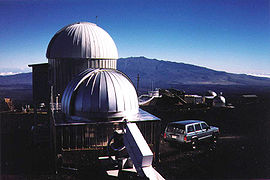
The observatory
Continuous emissions monitoring system
CEM systems were historically used as a tool to monitor flue gas for oxygen, carbon monoxide, and carbon dioxide to provide information for combustion control in industrial settings...
of atmospheric carbon dioxide
Carbon dioxide
Carbon dioxide is a naturally occurring chemical compound composed of two oxygen atoms covalently bonded to a single carbon atom...
(CO2), which is sometimes referred to as the Keeling Curve
Keeling curve
The Keeling Curve is a graph which plots the ongoing change in concentration of carbon dioxide in Earth's atmosphere since 1958. It is based on continuous measurements taken at the Mauna Loa Observatory in Hawaii under the supervision of Charles David Keeling. Keeling's measurements showed the...
. The observatory is under the Earth System Research Laboratory
Earth System Research Laboratory
The Earth System Research Laboratory is a laboratory in National Oceanic and Atmospheric Administration /Office of Oceanic and Atmospheric Research ....
which is part of the National Oceanic and Atmospheric Administration (NOAA)
National Oceanic and Atmospheric Administration
The National Oceanic and Atmospheric Administration , pronounced , like "noah", is a scientific agency within the United States Department of Commerce focused on the conditions of the oceans and the atmosphere...
.
The latest observation of CO2 concentrations from MLO can be found at web sites along with data from other sites, and trends at Mauna Loa. The MLO levels can be compared with other sites in the global monitoring network.
MLO has activities at five locations on the Big Island. The primary observing site is located at the 3397 m (11,141 ft) level on Mauna Loa's north slope, 19°32′10"N 155°34′34"W about 5 km north of the summit Mokuaweoweo. The Mauna Loa Solar Observatory
Mauna Loa Solar Observatory
The Mauna Loa Solar Observatory is a collection of instruments for observing the sun located on the slopes of the Mauna Loa volcano on the island of Hawaii, USA at an elevation of .-General information:...
shares this site. The administration and some data processing are done in the Hilo, Hawaii office. Kulani Mauka is a rain collection site. Cape Kumukahi is a flask sample site located on the eastern-most point of Hawaii. At the Hilo airport weekly balloon-borne instruments are prepared and launched to measure ozone
Ozone
Ozone , or trioxygen, is a triatomic molecule, consisting of three oxygen atoms. It is an allotrope of oxygen that is much less stable than the diatomic allotrope...
from the surface to usually over 30 km.
The observatory site is also a temporary home to a cosmic microwave background observatory called AMiBA
AMiBA
The Yuan-Tseh Lee Array for Microwave Background Anisotropy, also known as the Array for Microwave Background Anisotropy , is a radio telescope designed to observe the cosmic microwave background and the Sunyaev-Zel'dovich effect in clusters of galaxies...
.
Mauna Loa was originally chosen as a monitoring site because, located far from any continent, the air sampled is a good average for the central pacific. Being high, it is above the inversion layer
Inversion (meteorology)
In meteorology, an inversion is a deviation from the normal change of an atmospheric property with altitude. It almost always refers to a temperature inversion, i.e...
where most of the local effects are present. There was already a rough road to the summit built by the military. The contamination from local volcanic sources is sometimes detected at the observatory, and is then removed from the background data.