

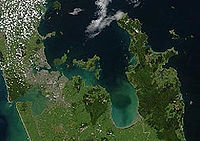
Hauraki Gulf
Encyclopedia
North Island
The North Island is one of the two main islands of New Zealand, separated from the much less populous South Island by Cook Strait. The island is in area, making it the world's 14th-largest island...
of New Zealand
New Zealand
New Zealand is an island country in the south-western Pacific Ocean comprising two main landmasses and numerous smaller islands. The country is situated some east of Australia across the Tasman Sea, and roughly south of the Pacific island nations of New Caledonia, Fiji, and Tonga...
. It has a total area of 4000 km², and lies between the Auckland Region
Auckland Region
The Auckland Region was one of the sixteen regions of New Zealand, named for the city of Auckland, the country's largest urban area. With one third of the nation's residents, it was by far the biggest population and economy of any region of New Zealand, but the second-smallest land area.On 1...
, the Hauraki Plains
Hauraki Plains
The Hauraki Plains are a geographical feature and non-administrative area located in the northern North Island of New Zealand, at the lower end of the Thames Valley...
, the Coromandel Peninsula
Coromandel Peninsula
The Coromandel Peninsula lies in the North Island of New Zealand. It is part of the Waikato Region and Thames-Coromandel District and extends 85 kilometres north from the western end of the Bay of Plenty, forming a natural barrier to protect the Hauraki Gulf and the Firth of Thames in the west...
and Great Barrier Island
Great Barrier Island
Great Barrier Island is a large island of New Zealand, situated to the north-east of central Auckland in the outer Hauraki Gulf. With an area of it is the fourth-largest island of New Zealand's main chain of islands, with its highest point, Mount Hobson, rising...
(which surround it in anticlockwise order). Most of the gulf is part of the Hauraki Gulf Marine Park.
Hauraki is Māori
Maori language
Māori or te reo Māori , commonly te reo , is the language of the indigenous population of New Zealand, the Māori. It has the status of an official language in New Zealand...
for North Wind.
Gulf
The gulfHeadlands and bays
Headlands and bays are two related features of the coastal environment.- Geology and geography :Headlands and bays are often found on the same coastline. A bay is surrounded by land on three sides, whereas a headland is surrounded by water on three sides. Headlands are characterized by high,...
is part of the Pacific Ocean
Pacific Ocean
The Pacific Ocean is the largest of the Earth's oceanic divisions. It extends from the Arctic in the north to the Southern Ocean in the south, bounded by Asia and Australia in the west, and the Americas in the east.At 165.2 million square kilometres in area, this largest division of the World...
, which it joins to the north and east. It is largely protected from the Pacific by Great Barrier Island
Great Barrier Island
Great Barrier Island is a large island of New Zealand, situated to the north-east of central Auckland in the outer Hauraki Gulf. With an area of it is the fourth-largest island of New Zealand's main chain of islands, with its highest point, Mount Hobson, rising...
and Little Barrier Island to the north, and by the 80-kilometre-long Coromandel Peninsula
Coromandel Peninsula
The Coromandel Peninsula lies in the North Island of New Zealand. It is part of the Waikato Region and Thames-Coromandel District and extends 85 kilometres north from the western end of the Bay of Plenty, forming a natural barrier to protect the Hauraki Gulf and the Firth of Thames in the west...
to the east. The gulf is thus well-protected against all but northern winds.
Three large channels join the gulf to the Pacific. Colville Channel
Colville Channel
The Colville Channel is one of three channels connecting the Hauraki Gulf with the Pacific Ocean to the northeast of Auckland, New Zealand. It is the easternmost channel, lying between the southern end of Great Barrier Island and Cape Colville at the northern tip of the Coromandel Peninsula...
lies between the Coromandel Peninsula and Great Barrier, Cradock Channel
Cradock Channel
The Cradock Channel is one of three channels connecting the Hauraki Gulf with the Pacific Ocean to the northeast of Auckland, New Zealand. It is the central channel, lying between Great Barrier Island to the east and Little Barrier Island to the west....
lies between the two islands, and Jellicoe Channel
Jellicoe Channel
The Jellicoe Channel is one of three channels connecting the Hauraki Gulf with the Pacific Ocean to the northeast of Auckland, New Zealand. It is the westernmost channel, lying between Cape Rodney on the North Auckland Peninsula and Little Barrier Island....
lies between Little Barrier and the North Auckland Peninsula
North Auckland Peninsula
The North Auckland Peninsula, frequently referred to simply as the Northland Peninsula, is located in the far north of the North Island of New Zealand. The peninsula is easily confused with, though not the same as Northland Region, which occupies the top 80% of the peninsula...
. To the north of Auckland several peninsulas jut into the gulf, notably the Whangaparaoa Peninsula
Whangaparaoa Peninsula
Whangaparaoa Peninsula is a peninsula and suburban area, around 25 km north of Auckland, New Zealand. Part of Rodney District, as of 2006, it had 22,788 residents, many of them in the eponymous town of Whangaparaoa on its southern side.-Geography:...
. Tiritiri Matangi Island
Tiritiri Matangi Island
Tiritiri Matangi Island lies in the Hauraki Gulf of New Zealand, east of the Whangaparaoa Peninsula in the North Island and north east of Auckland. The island is an open nature reserve managed under the supervision of the Department of Conservation and is noted for its bird life, including kiwi...
is near the end of this peninsula. Further north, Kawau Island nestles under the Tawharanui Peninsula
Tawharanui Peninsula
Tawharanui Peninsula is a finger of land projecting into the Hauraki Gulf from the east coast of the much larger North Auckland Peninsula of New Zealand. It separates Omaha Bay to the north from Kawau Bay and Kawau Island to the south...
.
Numerous beaches dot the shores of the gulf, many of them well known for swimming and surfing.
During the last glaciation period the whole gulf was dry land, with the sea level being around 100–110 m (300 ft) lower than at present. The gulf was submerged when the sea reached its current level around 7200 years ago.
Islands
In the west of the gulf lie a string of islands guarding the mouth of the Waitemata HarbourWaitemata Harbour
The quite famous Waitemata Harbour is the main access by sea to Auckland, New Zealand. For this reason it is often referred to as Auckland Harbour, despite the fact that it is only one of two harbours surrounding the city, and is crossed by the Auckland Harbour Bridge. The Waitemata forms the north...
, one of Auckland's two harbours. These include Ponui Island
Ponui Island
Ponui Island, also known as Chamberlin's Island, is located in the Hauraki Gulf, to the east of the city of Auckland, New Zealand. It is located to the southeast of Waiheke Island, at the eastern end of the Tamaki Strait, which separates the island from the Hunua Ranges on the mainland to the...
, Waiheke Island
Waiheke Island
Waiheke Island is an island in the Hauraki Gulf of New Zealand, located about from Auckland.The island is the second-largest in the Hauraki Gulf after Great Barrier Island. It is the most populated, with nearly 8,000 permanent residents plus another estimated 3,400 who have second or holiday homes...
, Tiritiri Matangi and the iconic dome of Rangitoto Island
Rangitoto Island
Rangitoto Island is a volcanic island in the Hauraki Gulf near Auckland, New Zealand. The 5.5 km wide island is an iconic and widely visible landmark of Auckland with its distinctive symmetrical shield volcano cone rising 260 metres high over the Hauraki Gulf...
(a dormant volcano
Volcano
2. Bedrock3. Conduit 4. Base5. Sill6. Dike7. Layers of ash emitted by the volcano8. Flank| 9. Layers of lava emitted by the volcano10. Throat11. Parasitic cone12. Lava flow13. Vent14. Crater15...
), which is connected to the much older Motutapu Island
Motutapu Island
Motutapu Island is a island in the Hauraki Gulf to the northeast of the city of Auckland, New Zealand. The island is part of the Hauraki Gulf Maritime Park....
by a causeway. The islands are separated from the mainland by the Tamaki Strait
Tamaki Strait
The Tamaki Strait is one of several passes between the islands of the inner Hauraki Gulf, close to the mouth of the Waitemata Harbour near Auckland city in New Zealand....
and Rangitoto Channel
Rangitoto Channel
The Rangitoto Channel is one of several passes between the islands of the inner Hauraki Gulf, close to the mouth of the Waitemata Harbour to the east of Auckland in New Zealand...
.
Other islands in the gulf include Browns Island
Browns Island, Auckland
Browns Island or Motukorea is a small New Zealand island, in the Hauraki Gulf north of Musick Point, one of the best preserved volcanoes in the Auckland Volcanic Field. The age of eruption is currently unknown. Due to centuries of cultivation, little native bush remains except on the north-eastern...
, Motuihe Island
Motuihe Island
Motuihe Island lies between Motutapu and Waiheke islands in the Hauraki Gulf of New Zealand, near Auckland. The island measures about , of which around are remnants of coastal forest. The island is a recreation reserve controlled by the Department of Conservation and administered by the Motuihe...
, Pakihi Island, Pakatoa Island
Pakatoa Island
Pakatoa Island covers and in the Hauraki Gulf of New Zealand. Purchased in the early 1900's by the Salvation Army it was used as an alcohol treatment centre for women, isolated from the Army's male rehabilitation facility on Rotoroa Island....
, Rakino Island
Rakino Island
Rakino Island is one of the many islands in the Hauraki Gulf, an arm of the Pacific Ocean to the northeast of Auckland, New Zealand.Rakino is a small island north-east of Motutapu Island. The island is long and about wide and has an area of . The two most popular bays have public access, but...
, and Rotoroa Island
Rotoroa Island
Rotoroa Island is an island to the east of Waiheke Island in the Hauraki Gulf of New Zealand. It covers . The Salvation Army purchased it for £400 in 1908 from the Ruthe family to expand their alcohol and drug rehabilitation facility at nearby Pakatoa Island. Men were treated at Home Bay at...
in the inner gulf, around Waiheke and Rangitoto; Tarahiki Island
Tarahiki Island
Tarahiki Island, also known as Shag Island, is a island in the Hauraki Gulf of New Zealand. Its highest point is ASL and it lies from the mainland and about east of Waiheke Island. It is well known for its breeding colony of up to 700 Spotted Shags....
just east of Waiheke; Motukawao Islands
Motukawao Islands
The Motukawao Islands are the northernmost of several small groups of islands that lie in the Hauraki Gulf off the west coast of the Coromandel Peninsula, New Zealand. They lie some to the southwest of Colville, and are uninhabited. The largest of the islands are Motuwi and Ngamotukaraka Islands;...
and Whanganui Island
Whanganui Island
Whanganui Island is the largest of a small group of islands at the entrance to Coromandel harbour in the Hauraki Gulf, off the coast of New Zealand's North Island.The island, which is privately owned, is in area...
in the lee of the Coromandel Peninsula; and Channel Island in the outer gulf.
Firth of Thames
At the southern end of the Hauraki Gulf is the wide, relatively shallow Firth of ThamesFirth of Thames
The Firth of Thames is a large bay located in the north of the North Island of New Zealand. It is the firth of the rivers Waihou and Piako, the former of which was formerly named the Thames River, and the town of Thames lies on its southeastern coast....
. Beyond this lie the Hauraki Plains
Hauraki Plains
The Hauraki Plains are a geographical feature and non-administrative area located in the northern North Island of New Zealand, at the lower end of the Thames Valley...
, drained by the Waihou River
Waihou River
thumb|The Waihou River near [[Putaruru]]The Waihou River is located in the northern North Island of New Zealand. Its former name, Thames River, was bestowed by Captain James Cook....
and the Piako River
Piako River
The Piako River is a lowland river system that drains into the Firth of Thames on the North Island of New Zealand. Together with the Waihou River, it is one of the two main rivers systems which drains the Hauraki Plains...
. The Hunua Ranges
Hunua Ranges
The Hunua Ranges form a block of hilly country to the southeast of Auckland in New Zealand's North Island. They cover some 250 square kilometres , containing 178 km² of parkland, and rise to 688 metres at Kohukohunui...
and hills of the Coromandel Peninsula
Coromandel Peninsula
The Coromandel Peninsula lies in the North Island of New Zealand. It is part of the Waikato Region and Thames-Coromandel District and extends 85 kilometres north from the western end of the Bay of Plenty, forming a natural barrier to protect the Hauraki Gulf and the Firth of Thames in the west...
rise on either side of the Firth.
Species overview
Some particular common or known animals in the Gulf include bottlenose and common dolphins, the latter of which sometimes are seen to aggregate into "super schools" of 300-500 animals or more, while various species of whales as well as orcaOrca
The killer whale , commonly referred to as the orca, and less commonly as the blackfish, is a toothed whale belonging to the oceanic dolphin family. Killer whales are found in all oceans, from the frigid Arctic and Antarctic regions to tropical seas...
s are also a relatively common sight, (there are approximately 25 species of marine mammals in the gulf). Nearly a third of the world's marine mammals live in or visit the Marine Park.
In terms of birdlife, many of the islands in the Gulf are either official or unofficial bird sanctuaries, holding such important or even critically endangered species like Kiwis, Takahes, Brown teals or Grey-faced petrels. Centred around the main conservation island of Tiritri Matangi and Little Barrier Island, numerous bird species that were locally extinct have been reintroduced in the last decades, while there have also been some naturally occurring bird "re-colonisations", especially after introduced pests were removed from breeding and nesting grounds.
Environmental damage
The gulf is a vibrant natural environment, which has however seen significant damage during the 20th and early 21st century from human use. A major study by the Hauraki Gulf Forum in 2011 found that essentially all environmental indicators were still worsening, or stable at problematic levels, leading a major newspaper to title the Gulf a "toxic paradise".Particularly damaging were the introduction of industrialised fishing, with for example snapper
Lutjanidae
Snappers are a family of perciform fish, mainly marine but with some members inhabiting estuaries, feeding in freshwater. Some are important food fish. One of the best known is the red snapper....
fishing peaking in the 1970s at more than 10,000 tonnes a year (though even in the 2000s, private fishing of this species is also a considerable factor, weighing in at 400-800 tonnes a year). This severe overfishing, which unbalanced the marine environment by the removal of a main predator in the food chain, led to further degradation, such as a widespread disappearance of kelp
Kelp
Kelps are large seaweeds belonging to the brown algae in the order Laminariales. There are about 30 different genera....
beds as they were overtaken by kina barrens. Trawler fishing in general is seen as severely damaging the gulf, and lobster stock are also reported as not rebuilding. It is estimated that today's fish stocks are around 25% of pre-European levels.
Also particularly damaging are the results of nitrogen carried into the gulf from surrounding agricultural land, with almost 90% coming from the dairy-farming runoff into the Firth of Thames
Firth of Thames
The Firth of Thames is a large bay located in the north of the North Island of New Zealand. It is the firth of the rivers Waihou and Piako, the former of which was formerly named the Thames River, and the town of Thames lies on its southeastern coast....
.
Other exploitation such as the dredging of the mussel
Mussel
The common name mussel is used for members of several families of clams or bivalvia mollusca, from saltwater and freshwater habitats. These groups have in common a shell whose outline is elongated and asymmetrical compared with other edible clams, which are often more or less rounded or oval.The...
beds of the Firth of Thames
Firth of Thames
The Firth of Thames is a large bay located in the north of the North Island of New Zealand. It is the firth of the rivers Waihou and Piako, the former of which was formerly named the Thames River, and the town of Thames lies on its southeastern coast....
, reaching its height in 1961 with an estimated 15 million mussels taken (shortly before collapse of the industry) have led to damages which have not been recovered forty years later, possibly due to the dredging having destroyed the underwater surfaces, and sediment drainage from the agriculture in the Firth of Thames affecting the mussle's viability.
Bryde's whale
Bryde's Whale
Bryde's whales are baleen whales, one of the "great whales" or rorquals. They prefer tropical and temperate waters over the polar seas that other whales in their family frequent. They are largely coastal rather than pelagic. Bryde's whales are very similar in appearance to sei whales and almost as...
s are relatively common in the Gulf, and their presence in these busily travelled waters leads to a large number of ship strikes, with sometimes several of the whales dying each year from collisions with shipping vessels or sport boats. The population remaining is estimated to be between 100-200.
Other environmental problems exist around urban areas, with 14 out of 52 beaches in the Auckland Region at least sometimes showing unsafe pollution levels (mostly because of untreated sewage
Sewage
Sewage is water-carried waste, in solution or suspension, that is intended to be removed from a community. Also known as wastewater, it is more than 99% water and is characterized by volume or rate of flow, physical condition, chemical constituents and the bacteriological organisms that it contains...
) for bathing. Further, voluntary coast clean-up groups report about 450,000 litres of litter collected from the shoreline, with actual volumes stranded even larger.
Marine Park
Legal establishment
Sections 7 and 8 of the Hauraki Gulf Marine Park Act 2000 state:7 Recognition of national significance of Hauraki Gulf
- (1) The interrelationship between the Hauraki Gulf, its islands, and catchments and the ability of that interrelationship to sustain the life-supporting capacity of the environment of the Hauraki Gulf and its islands are matters of national significance.
- (2) The life-supporting capacity of the environment of the Gulf and its islands includes the capacity—
- (a) to provide for—
- (i) the historic, traditional, cultural, and spiritual relationship of the tangata whenuaTangata WhenuaTāngata whenua is a Māori term of the indigenous peoples of New Zealand and literally means "people of the land", from tāngata, 'people' and whenua land.-Meanings:...
of the Gulf with the Gulf and its islands; and - (ii) the social, economic, recreational, and cultural well-being of people and communities:
- (i) the historic, traditional, cultural, and spiritual relationship of the tangata whenua
- (b) to use the resources of the Gulf by the people and communities of the Gulf and New Zealand for economic activities and recreation:
- (c) to maintain the soil, air, water, and ecosystems of the Gulf.
- (a) to provide for—
8 Management of Hauraki Gulf
- To recognise the national significance of the Hauraki Gulf, its islands, and catchments, the objectives of the management of the Hauraki Gulf, its islands, and catchments are—
-
- (a) the protection and, where appropriate, the enhancement of the life-supporting capacity of the environment of the Hauraki Gulf, its islands, and catchments:
- (b) the protection and, where appropriate, the enhancement of the natural, historic, and physical resources of the Hauraki Gulf, its islands, and catchments:
- (c) the protection and, where appropriate, the enhancement of those natural, historic, and physical resources (including kaimoana) of the Hauraki Gulf, its islands, and catchments with which tangata whenua have an historic, traditional, cultural, and spiritual relationship:
- (d) the protection of the cultural and historic associations of people and communities in and around the Hauraki Gulf with its natural, historic, and physical resources:
- (e) the maintenance and, where appropriate, the enhancement of the contribution of the natural, historic, and physical resources of the Hauraki Gulf, its islands, and catchments to the social and economic well-being of the people and communities of the Hauraki Gulf and New Zealand:
- (f) the maintenance and, where appropriate, the enhancement of the natural, historic, and physical resources of the Hauraki Gulf, its islands, and catchments, which contribute to the recreation and enjoyment of the Hauraki Gulf for the people and communities of the Hauraki Gulf and New Zealand.
-