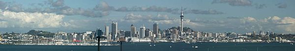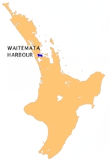
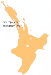
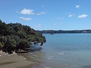
Waitemata Harbour
Encyclopedia

Auckland
The Auckland metropolitan area , in the North Island of New Zealand, is the largest and most populous urban area in the country with residents, percent of the country's population. Auckland also has the largest Polynesian population of any city in the world...
, New Zealand
New Zealand
New Zealand is an island country in the south-western Pacific Ocean comprising two main landmasses and numerous smaller islands. The country is situated some east of Australia across the Tasman Sea, and roughly south of the Pacific island nations of New Caledonia, Fiji, and Tonga...
. For this reason it is often referred to as Auckland Harbour, despite the fact that it is only one of two harbours surrounding the city, and is crossed by the Auckland Harbour Bridge
Auckland Harbour Bridge
The Auckland Harbour Bridge is an eight-lane box truss motorway bridge over the Waitemata Harbour, joining St Marys Bay in Auckland with Northcote in North Shore City, New Zealand. The bridge is part of State Highway 1 and the Auckland Northern Motorway...
. The Waitemata forms the north and east coasts of the Auckland isthmus. It is matched on the south by the shallower waters of Manukau Harbour
Manukau Harbour
Manukau Harbour is the second largest natural harbour in New Zealand by area. It is located to the southwest of the Auckland isthmus, and is an arm of the Tasman Sea.-Geography:...
.
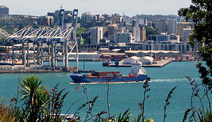
With a size of 70 square miles, it connects the city's main port
Ports of Auckland
Ports of Auckland Limited , the successor to the Auckland Harbour Board, is the company administering Auckland's commercial freight and cruise ship harbour facilities...
and the Auckland waterfront
Auckland waterfront
The Auckland waterfront is a city-side stretch of the southern Waitemata Harbour coastline in Auckland City, New Zealand...
to the Hauraki Gulf
Hauraki Gulf
The Hauraki Gulf is a coastal feature of the North Island of New Zealand. It has a total area of 4000 km², and lies between the Auckland Region, the Hauraki Plains, the Coromandel Peninsula and Great Barrier Island...
, and the Pacific Ocean
Pacific Ocean
The Pacific Ocean is the largest of the Earth's oceanic divisions. It extends from the Arctic in the north to the Southern Ocean in the south, bounded by Asia and Australia in the west, and the Americas in the east.At 165.2 million square kilometres in area, this largest division of the World...
. It is sheltered from Pacific storms by Auckland's North Shore
North Shore, New Zealand
North Shore City was the name of a city that existed in the Auckland region of New Zealand from 1989 until 2010. The city had a population of making it the fourth most populous city in New Zealand prior to November 2010...
, Rangitoto Island
Rangitoto Island
Rangitoto Island is a volcanic island in the Hauraki Gulf near Auckland, New Zealand. The 5.5 km wide island is an iconic and widely visible landmark of Auckland with its distinctive symmetrical shield volcano cone rising 260 metres high over the Hauraki Gulf...
and Waiheke Island
Waiheke Island
Waiheke Island is an island in the Hauraki Gulf of New Zealand, located about from Auckland.The island is the second-largest in the Hauraki Gulf after Great Barrier Island. It is the most populated, with nearly 8,000 permanent residents plus another estimated 3,400 who have second or holiday homes...
.
The name is from the Māori language
Maori language
Māori or te reo Māori , commonly te reo , is the language of the indigenous population of New Zealand, the Māori. It has the status of an official language in New Zealand...
, with Wai te Mataa referring to obsidian
Obsidian
Obsidian is a naturally occurring volcanic glass formed as an extrusive igneous rock.It is produced when felsic lava extruded from a volcano cools rapidly with minimum crystal growth...
glass. The 'sparkling waters' (a later translation of the meaning) of the harbour were said to glint like the volcanic glass prized by these early arrivals to the harbour.
Overview
Rangitoto Channel
The Rangitoto Channel is one of several passes between the islands of the inner Hauraki Gulf, close to the mouth of the Waitemata Harbour to the east of Auckland in New Zealand...
. Its entrance is between North Head
North Head, New Zealand
North Head is a volcanic cone forming a headland within North Shore City, New Zealand, in the suburb of Devonport at the east end of the Waitemata Harbour ....
and Bastion Point
Bastion Point
Bastion Point is a coastal piece of land in Orakei, Auckland, New Zealand, overlooking the Waitemata Harbour. The area has significance in New Zealand history for its role in 1970s Māori protests against forced land alienation by non Māori New Zealanders.-History:The land was occupied by Ngāti...
in the south. The westernmost ends of the harbour extend past Whenuapai
Whenuapai
Whenuapai is a suburb and airport located in the western Waitakere area of Auckland City, in the North Island of New Zealand. It is located on the northwestern shore of the Waitemata Harbour, 15 kilometres to the northwest of Auckland's city centre. It is one of the landing points for the Southern...
in the northwest, and to Te Atatu
Te Atatu
Te Atatu is the name of two suburbs in western Auckland, New Zealand: Te Atatu Peninsula and Te Atatu South. They are located next to each other some 10 kilometres to the west of the Auckland city centre....
in the west, as well as forming the estuarial arm known as the Whau River
Whau River
The Whau River is an estuarial arm of the southwestern Waitemata Harbour within the Auckland metropolitan area in New Zealand. It flows north for 5.7 kilometres from its origin at the confluence of the Avondale Stream and Whau Stream to its mouth between the Te Atatu peninsula and the long, thin...
in the southwest.
The north shore of the harbour is formed by North Shore City, one of several separate cities within Greater Auckland
Auckland
The Auckland metropolitan area , in the North Island of New Zealand, is the largest and most populous urban area in the country with residents, percent of the country's population. Auckland also has the largest Polynesian population of any city in the world...
. Suburbs located close to the shore here include Birkenhead
Birkenhead, New Zealand
Birkenhead is a suburb of Auckland, in northern New Zealand. It is located on the north shore of the Waitemata Harbour, four kilometres northwest of the Auckland city centre....
, Northcote
Northcote, New Zealand
Northcote is a suburb of North Shore City, one of several cities in the Auckland metropolitan area in northern New Zealand. It is located on the north shore of the Waitemata Harbour, four kilometres northwest of the Auckland city centre....
and Devonport
Devonport, New Zealand
Devonport is a harbourside suburb of Auckland, New Zealand. It is located on the North Shore, at the southern end of a peninsula that runs southeast from near Lake Pupuke in Takapuna, forming the northern side of the Waitemata Harbour...
(west to east). To the south is the heart of Auckland City
Auckland City
Auckland City was the city and local authority covering the Auckland isthmus and most of the islands of the Hauraki Gulf, in the North Island of New Zealand. On 1 November 2010 it was amalgamated into the wider Auckland Region under the authority of the new Auckland Council...
, with the Auckland waterfront
Auckland waterfront
The Auckland waterfront is a city-side stretch of the southern Waitemata Harbour coastline in Auckland City, New Zealand...
, as well as coastal suburbs such as Mission Bay
Mission Bay, New Zealand
Mission Bay is a suburb of Auckland city, in the North Island of New Zealand. It is located seven kilometres to the east of the city centre, on the southern shore of the Waitemata Harbour. At the census of 2001, Mission Bay was reported to have a population of 5235.The Mission Bay district has been...
, Parnell
Parnell, New Zealand
Parnell is a suburb of Auckland, New Zealand. It is often billed as Auckland's "oldest suburb" since it dates from the earliest days of the European settlement of Auckland in 1841...
, Herne Bay
Herne Bay, New Zealand
Herne Bay is a suburb of Auckland, New Zealand. It is located on the southwestern shore of the Waitemata Harbour to the west of the Auckland Harbour Bridge.Herne Bay is under the local governance of the Auckland City Council....
and Point Chevalier
Point Chevalier
Point Chevalier is a suburb and peninsula in the west of the city of Auckland in the north of New Zealand. It is located five kilometres to the west of the city centre on the southern shore of the Waitemata Harbour....
(east to west), the latter of which lies on a short triangular peninsula jutting into the harbour.
The harbour is crossed at its narrowest point by the Auckland Harbour Bridge
Auckland Harbour Bridge
The Auckland Harbour Bridge is an eight-lane box truss motorway bridge over the Waitemata Harbour, joining St Marys Bay in Auckland with Northcote in North Shore City, New Zealand. The bridge is part of State Highway 1 and the Auckland Northern Motorway...
. To the east of its southern end lie the marinas of Westhaven, as well as the suburbs of Freemans Bay
Freemans Bay
Freemans Bay is the name of a former bay and now inner city suburb of Auckland, in the North Island of New Zealand. The historical bay was filled in to a large extent, and lost its shoreline to reclamation works...
and the Viaduct Basin
Viaduct Basin
Viaduct Basin is a former commercial harbour on the Auckland waterfront, now turned into a development of mostly upscale apartments, office space and restaurants. It is located on the site of a formerly run-down area of the Freemans Bay / Auckland CBD waterfront in Auckland City, New Zealand...
. Further east from these, and close to the harbour's entrance, lies the Port of Auckland
Ports of Auckland
Ports of Auckland Limited , the successor to the Auckland Harbour Board, is the company administering Auckland's commercial freight and cruise ship harbour facilities...
.
There are other wharves and ports within the harbour, notable among them the Devonport Naval Base
Devonport Naval Base
Devonport Naval Base is the home of the Royal New Zealand Navy, located at Devonport, New Zealand on Auckland's North Shore. It is currently the only base of the navy that operates ships, and was a navy base from as far back as 1841...
, and its accompanying ammunition dump at Kauri Point, Birkenhead
Birkenhead, New Zealand
Birkenhead is a suburb of Auckland, in northern New Zealand. It is located on the north shore of the Waitemata Harbour, four kilometres northwest of the Auckland city centre....
, and the Chelsea Sugar Refinery
Chelsea Sugar Refinery
The Chelsea Sugar Refinery, also known colloquially as "Chelsea" and the "sugar works", is a long-established business and landmark in Birkenhead, New Zealand, located on the northern shore of Auckland's Waitemata Harbour. It was established in 1884, and remains New Zealand's main source of sugar...
wharf, all capable of taking ships over . Smaller wharves at Birkenhead, Northcote
Northcote, New Zealand
Northcote is a suburb of North Shore City, one of several cities in the Auckland metropolitan area in northern New Zealand. It is located on the north shore of the Waitemata Harbour, four kilometres northwest of the Auckland city centre....
, Devonport
Devonport, New Zealand
Devonport is a harbourside suburb of Auckland, New Zealand. It is located on the North Shore, at the southern end of a peninsula that runs southeast from near Lake Pupuke in Takapuna, forming the northern side of the Waitemata Harbour...
and West Harbour offer commuter ferry services to the Auckland CBD
Auckland CBD
The Auckland CBD is the geographical and economic heart of the Auckland metropolitan area. Bounded by several major motorways and by the harbour coastline in the north, it is surrounded further out by mostly suburban areas...
.
Geology
The harbour is in fact a drowned valley system in marine sediments deposited during the MioceneMiocene
The Miocene is a geological epoch of the Neogene Period and extends from about . The Miocene was named by Sir Charles Lyell. Its name comes from the Greek words and and means "less recent" because it has 18% fewer modern sea invertebrates than the Pliocene. The Miocene follows the Oligocene...
. Recent volcanism in the Auckland volcanic field
Auckland Volcanic Field
The Auckland volcanic field is a monogenetic volcanic field in the North Island of New Zealand. Basaltic in nature, it underlies much of the metropolitan area of Auckland....
has also shaped the coast, most obviously at Devonport and the Meola Reef
Meola Reef
The Meola Reef, or Te Tokaroa Reef in Māori is a lava flow forming a reef peninsula across part of Auckland's Waitemata Harbour, New Zealand. It was formed 20,000 years ago from the final portion of a 10 kilometer long lava flow that originated from the distant Three Kings volcano...
(a lava flow which almost spans the harbour), but also in the explosion craters of Orakei Basin
Orakei Basin
Orakei Basin is one of the volcanoes in the Auckland Volcanic Field. It has an explosion crater around 700 m wide, with a surrounding tuff ring. After eruption about 85,000 yrs ago, it became a freshwater lake that had an overflow stream in the vicinity of present Orakei Rd bridge...
and in western Shoal Bay
Shoal Bay
Shoal Bay may refer to:Australia* Shoal Bay, New South Wales* Shoal Bay , Northern Territory** Shoal Bay Receiving Station* Shoal Bay , Western AustraliaCanada* Shoal Bay, British Columbia...
. In periods of low sea level, a tributary ran from Milford into the Shoal Bay stream. This valley provided the harbour with a second entrance when sea levels rose, until the Lake Pupuke
Lake Pupuke
Lake Pupuke is a heart-shaped freshwater lake occupying a volcanic explosion crater between the suburbs of Takapuna and Milford on the North Shore of Auckland, New Zealand. The heart shape is a result of its formation by the linking of two circular craters - a larger one forming most of the lake...
volcano plugged this gap.
The current shore is strongly influenced by tidal rivers, particularly in the west and north of the harbour. Mudflat
Mudflat
Mudflats or mud flats, also known as tidal flats, are coastal wetlands that form when mud is deposited by tides or rivers. They are found in sheltered areas such as bays, bayous, lagoons, and estuaries. Mudflats may be viewed geologically as exposed layers of bay mud, resulting from deposition of...
s covered by mangrove
Mangrove
Mangroves are various kinds of trees up to medium height and shrubs that grow in saline coastal sediment habitats in the tropics and subtropics – mainly between latitudes N and S...
s flourish in these conditions, and salt marsh
Salt marsh
A salt marsh is an environment in the upper coastal intertidal zone between land and salt water or brackish water, it is dominated by dense stands of halophytic plants such as herbs, grasses, or low shrubs. These plants are terrestrial in origin and are essential to the stability of the salt marsh...
es are also typical.
History
The harbour has long been the main anchorage and port area for the Auckland area, even before European colonial times. Well sheltered not only by the Hauraki Gulf itself but also by Rangitoto Island, the harbour offered good protection in almost all winds, and lacked dangerous shoals or major sand bars (like on the Manukau HarbourManukau Harbour
Manukau Harbour is the second largest natural harbour in New Zealand by area. It is located to the southwest of the Auckland isthmus, and is an arm of the Tasman Sea.-Geography:...
) that would have made entry difficult. The harbour also proved a fertile area for encroaching development, with major land reclamation
Land reclamation
Land reclamation, usually known as reclamation, is the process to create new land from sea or riverbeds. The land reclaimed is known as reclamation ground or landfill.- Habitation :...
undertaken, especially along the Auckland waterfront
Auckland waterfront
The Auckland waterfront is a city-side stretch of the southern Waitemata Harbour coastline in Auckland City, New Zealand...
, within a few decades of the city's European founding.
Taking the idea of the several Māori portage
Portage
Portage or portaging refers to the practice of carrying watercraft or cargo over land to avoid river obstacles, or between two bodies of water. A place where this carrying occurs is also called a portage; a person doing the carrying is called a porter.The English word portage is derived from the...
paths over the isthmus one step further, a potential Waitemata Harbour-Manukau Harbour canal was considered in the early 1900s, and legislation, the Auckland and Manukau Canal Act 1908, was passed that would allow authorities to take privately owned land where it was deemed required for a canal. However, no serious work (or land take) was undertaken. The act is technically still in force as of 2008.
Panoramas