

Guide Rock (hill)
Encyclopedia
Guide Rock, whose Pawnee name is Pa-hur or Pahur, is a hill in south central Nebraska
in the United States
. In the traditional Pawnee religion, it was one of five dwelling places of spirit animals with miraculous powers.
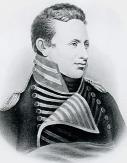
In 1806, Zebulon Pike
found a large Pawnee village nearby; he persuaded the inhabitants to lower the flag of Spain and replace it with that of the United States.
The hill's English name was given to the nearby village of Guide Rock, Nebraska
.
. It lies southeast of the town that bears its name, on the south side of the Republican River
and just east of Rankin Creek.
Descriptions of the landform vary. The United States Geological Survey
classifies it as a "pillar", which it defines as a "[v]ertical, standing, often spire-shaped, natural rock formation".
A local writer described it as a "vast rocky bluff".
However, the authors of Roadside Geology of Nebraska state that it is "not so much a rock as a loess
bluff of modest size".
The difference might be due to human action: in 1973, it was reported that of the five sacred places of the Pawnee, four, including this one, had been "extensively damaged or totally destroyed".
The nahurac had five lodges. The foremost among them was Pahuk
, usually translated "hill island", a bluff on the south side of the Platte River
, near the town of Cedar Bluffs
in present-day Saunders County, Nebraska
.
Lalawakohtito, or "dark island", was an island in the Platte near Central City, Nebraska
; Ahkawitakol, or "white bank", was on the Loup River
opposite the mouth of the Cedar River in what is now Nance County, Nebraska
. Kitzawitzuk, translated "water on a bank", also known to the Pawnee as Pahowa, was a spring on the Solomon River
near Glen Elder, Kansas
; it is usually known today by its Kanza
-derived name of Waconda Spring
. It now lies beneath the waters of Waconda Reservoir.
The fifth lodge of the nahurac was known to the Pawnee as Pahur, a name translated as "hill that points the way". According to George Bird Grinnell
, the accent is on the second syllable; the "a" in the first syllable is pronounced like the "a" in "father"; and the "u" in the second syllable is pronounced long, like the vowel in "pool". In English, the name was shortened to "Guide Rock".
The village was intermittently occupied from about 1770 to 1830.
After the Louisiana Purchase
, the United States found itself embroiled in a conflict with Spain, which disputed the boundaries of the Louisiana Territory
, contending that most of the territory west of the Mississippi River
belonged to them. The Spanish dispatched four expeditions from Santa Fe
to find and arrest the Lewis and Clark Expedition
. The fourth of these, in 1806, consisted of over 600 men under Lieutenant Facundo Melgares; its size was intended to impress the Native Americans of the area and to secure their cooperation with Spain against the United States.
 The United States also sent out an expedition in 1806. General James Wilkinson
, the newly-appointed governor of the Louisiana Territory, dispatched Zebulon Pike
and 23 men to explore the headwaters of the Arkansas
and Red Rivers, to negotiate peace between the Native American
tribes of the area, and to contact the Comanche
of the High Plains
.
Melgares and 360 of his men arrived at the Guide Rock Pawnee village.
They gave presents and a Spanish flag to the inhabitants, and requested that they block travel west and southwest into Spanish-claimed territory by anyone from the United States.
Rather than continuing toward the Missouri, they then returned to the Arkansas River, where they rejoined the rest of their party; from there, they returned to Santa Fe. The failure of their expediiton has been attributed to Pawnee opposition, combined with the difficulty of maintaining a force of that size on the country with no supply lines.
The Pike party arrived at the Guide Rock village on September 25, 1806, a few weeks after Melgares's departure, and remained there for nearly two weeks. While there, Pike persuaded the Pawnee to haul down the Spanish flag that they had been given by Melgares, and to replace it with an American flag.
However, he left the Spanish flag in the possession of the Pawnee, only asking that they not fly it while his party was in the village.
When Pike prepared to depart, the Pawnee informed him that they would oppose his attempt to continue westward. Melgares had requested that they prevent such travel; furthermore, they did not want the United States to establish relations with their Comanche enemies. Pike refused to be intimidated, making it clear that if fighting ensued, his party would kill a great many Pawnee before their own extermination. In the end, the Pawnee relented, and Pike's expedition was allowed to proceed.
in Webster County was established on the north side of the Republican River.
By a unanimous vote of eight settlers, it was named Guide Rock
after the nearby hill.
An annual festival held in Guide Rock is called "Pa-Hur Days".
Nebraska
Nebraska is a state on the Great Plains of the Midwestern United States. The state's capital is Lincoln and its largest city is Omaha, on the Missouri River....
in the United States
United States
The United States of America is a federal constitutional republic comprising fifty states and a federal district...
. In the traditional Pawnee religion, it was one of five dwelling places of spirit animals with miraculous powers.
In 1806, Zebulon Pike
Zebulon Pike
Zebulon Montgomery Pike Jr. was an American officer and explorer for whom Pikes Peak in Colorado is named. As a United States Army captain in 1806-1807, he led the Pike Expedition to explore and document the southern portion of the Louisiana Purchase and to find the headwaters of the Red River,...
found a large Pawnee village nearby; he persuaded the inhabitants to lower the flag of Spain and replace it with that of the United States.
The hill's English name was given to the nearby village of Guide Rock, Nebraska
Guide Rock, Nebraska
Guide Rock is a village in Webster County, Nebraska, United States. The population was 245 at the 2000 census. The town was the first settlement in Webster County, with the first white settlers arriving in 1870. The town was named after Guide Rock, a hill on the opposite bank of the Republican River...
.
Description
Guide Rock is located in Webster County, NebraskaWebster County, Nebraska
-History:Webster County was formed in 1871. It was named after the statesman Daniel Webster.-Demographics:As of the census of 2000, there were 4,061 people, 1,708 households, and 1,118 families residing in the county. The population density was 7 people per square mile . There were 1,972 housing...
. It lies southeast of the town that bears its name, on the south side of the Republican River
Republican River
The Republican River is a river in the central Great Plains of North America, flowing through the U.S. states of Nebraska and Kansas.-Geography:...
and just east of Rankin Creek.
Descriptions of the landform vary. The United States Geological Survey
United States Geological Survey
The United States Geological Survey is a scientific agency of the United States government. The scientists of the USGS study the landscape of the United States, its natural resources, and the natural hazards that threaten it. The organization has four major science disciplines, concerning biology,...
classifies it as a "pillar", which it defines as a "[v]ertical, standing, often spire-shaped, natural rock formation".
A local writer described it as a "vast rocky bluff".
However, the authors of Roadside Geology of Nebraska state that it is "not so much a rock as a loess
Loess
Loess is an aeolian sediment formed by the accumulation of wind-blown silt, typically in the 20–50 micrometre size range, twenty percent or less clay and the balance equal parts sand and silt that are loosely cemented by calcium carbonate...
bluff of modest size".
The difference might be due to human action: in 1973, it was reported that of the five sacred places of the Pawnee, four, including this one, had been "extensively damaged or totally destroyed".
Pawnee traditional belief
In the Pawnee traditional religion, the supreme being Tirawa allots supernatural powers to certain animals. These animals, the nahurac, act as Tirawa's servants and messengers, and intercede for the Pawnee with Tirawa.The nahurac had five lodges. The foremost among them was Pahuk
Pahuk
Pahuk, also written Pahaku, or Pahuk Hill, is a bluff on the Platte River in eastern Nebraska in the United States. In the traditional Pawnee religion, it was one of five dwellings of spirit animals with miraculous powers...
, usually translated "hill island", a bluff on the south side of the Platte River
Platte River
The Platte River is a major river in the state of Nebraska and is about long. Measured to its farthest source via its tributary the North Platte River, it flows for over . The Platte River is a tributary of the Missouri River, which in turn is a tributary of the Mississippi River which flows to...
, near the town of Cedar Bluffs
Cedar Bluffs, Nebraska
Cedar Bluffs is a village in Saunders County, Nebraska, United States. The population was 615 at the 2000 census. Cedar Bluffs was a point on the Mormon, Oregon, and California Trails.-Geography:Cedar Bluffs is located at ....
in present-day Saunders County, Nebraska
Saunders County, Nebraska
-History:Saunders County was established by an 1856 act of the Nebraska Territorial Legislature; its boundaries were redefined in 1858. The county was originally named after John C...
.
Lalawakohtito, or "dark island", was an island in the Platte near Central City, Nebraska
Central City, Nebraska
Central City is a city in Merrick County, Nebraska, United States. It is part of the Grand Island, Nebraska Micropolitan Statistical Area. The population was 2,998 at the 2000 census...
; Ahkawitakol, or "white bank", was on the Loup River
Loup River
The Loup River is a tributary of the Platte River, approximately long, in central Nebraska in the United States. The river drains a sparsely populated rural agricultural area on the eastern edge of the Great Plains southeast of the Sandhills...
opposite the mouth of the Cedar River in what is now Nance County, Nebraska
Nance County, Nebraska
-History:The land that comprises Nance County was originally part of the Pawnee Reservation, created in 1857 when the Pawnee Indians signed a treaty with the United States ceding its lands in exchange for the reservation. After the state of Nebraska was admitted into the Union, the state government...
. Kitzawitzuk, translated "water on a bank", also known to the Pawnee as Pahowa, was a spring on the Solomon River
Solomon River
The Solomon River, often referred to as the "Solomon Fork", is a river in the central Great Plains of North America. The entire length of the river lies in the U.S. state of Kansas. It is a tributary of the Smoky Hill River.-Names:...
near Glen Elder, Kansas
Glen Elder, Kansas
Glen Elder is a city in Mitchell County, Kansas, United States. As of the 2010 census, the city population was 445.-Geography:Glen Elder is located at...
; it is usually known today by its Kanza
Kaw (tribe)
The Kaw Nation are an American Indian people of the central Midwestern United States. The tribe known as Kaw have also been known as the "People of the South wind", "People of water", Kansa, Kaza, Kosa, and Kasa. Their tribal language is Kansa, classified as a Siouan language.The toponym "Kansas"...
-derived name of Waconda Spring
Waconda Spring
Waconda Spring, or Great Spirit Spring, was a natural artesian spring located in Mitchell County, near the towns of Glen Elder and Cawker City in the U.S. state of Kansas. It was a sacred site for Native American tribes of the Great Plains and, for a time, became the site of a health spa for...
. It now lies beneath the waters of Waconda Reservoir.
The fifth lodge of the nahurac was known to the Pawnee as Pahur, a name translated as "hill that points the way". According to George Bird Grinnell
George Bird Grinnell
George Bird Grinnell was an American anthropologist, historian, naturalist, and writer. Grinnell was born in Brooklyn, New York, and graduated from Yale University with a B.A. in 1870 and a Ph.D. in 1880. Originally specializing in zoology, he became a prominent early conservationist and student...
, the accent is on the second syllable; the "a" in the first syllable is pronounced like the "a" in "father"; and the "u" in the second syllable is pronounced long, like the vowel in "pool". In English, the name was shortened to "Guide Rock".
Pawnee village
The Pawnee tended to locate major population centers near homes of the nahurac. Pahur was no exception: a large village of the Kitkehahki, or Republican Pawnee, was situated a short distance upstream from the hill.The village was intermittently occupied from about 1770 to 1830.
After the Louisiana Purchase
Louisiana Purchase
The Louisiana Purchase was the acquisition by the United States of America of of France's claim to the territory of Louisiana in 1803. The U.S...
, the United States found itself embroiled in a conflict with Spain, which disputed the boundaries of the Louisiana Territory
Louisiana Territory
The Territory of Louisiana or Louisiana Territory was an organized incorporated territory of the United States that existed from July 4, 1805 until June 4, 1812, when it was renamed to Missouri Territory...
, contending that most of the territory west of the Mississippi River
Mississippi River
The Mississippi River is the largest river system in North America. Flowing entirely in the United States, this river rises in western Minnesota and meanders slowly southwards for to the Mississippi River Delta at the Gulf of Mexico. With its many tributaries, the Mississippi's watershed drains...
belonged to them. The Spanish dispatched four expeditions from Santa Fe
Santa Fe, New Mexico
Santa Fe is the capital of the U.S. state of New Mexico. It is the fourth-largest city in the state and is the seat of . Santa Fe had a population of 67,947 in the 2010 census...
to find and arrest the Lewis and Clark Expedition
Lewis and Clark Expedition
The Lewis and Clark Expedition, or ″Corps of Discovery Expedition" was the first transcontinental expedition to the Pacific Coast by the United States. Commissioned by President Thomas Jefferson and led by two Virginia-born veterans of Indian wars in the Ohio Valley, Meriwether Lewis and William...
. The fourth of these, in 1806, consisted of over 600 men under Lieutenant Facundo Melgares; its size was intended to impress the Native Americans of the area and to secure their cooperation with Spain against the United States.
James Wilkinson
James Wilkinson was an American soldier and statesman, who was associated with several scandals and controversies. He served in the Continental Army during the American Revolutionary War, but was twice compelled to resign...
, the newly-appointed governor of the Louisiana Territory, dispatched Zebulon Pike
Zebulon Pike
Zebulon Montgomery Pike Jr. was an American officer and explorer for whom Pikes Peak in Colorado is named. As a United States Army captain in 1806-1807, he led the Pike Expedition to explore and document the southern portion of the Louisiana Purchase and to find the headwaters of the Red River,...
and 23 men to explore the headwaters of the Arkansas
Arkansas River
The Arkansas River is a major tributary of the Mississippi River. The Arkansas generally flows to the east and southeast as it traverses the U.S. states of Colorado, Kansas, Oklahoma, and Arkansas. The river's initial basin starts in the Western United States in Colorado, specifically the Arkansas...
and Red Rivers, to negotiate peace between the Native American
Native Americans in the United States
Native Americans in the United States are the indigenous peoples in North America within the boundaries of the present-day continental United States, parts of Alaska, and the island state of Hawaii. They are composed of numerous, distinct tribes, states, and ethnic groups, many of which survive as...
tribes of the area, and to contact the Comanche
Comanche
The Comanche are a Native American ethnic group whose historic range consisted of present-day eastern New Mexico, southern Colorado, northeastern Arizona, southern Kansas, all of Oklahoma, and most of northwest Texas. Historically, the Comanches were hunter-gatherers, with a typical Plains Indian...
of the High Plains
High Plains (United States)
The High Plains are a subregion of the Great Plains mostly in the Western United States, but also partly in the Midwest states of Nebraska, Kansas, and South Dakota, generally encompassing the western part of the Great Plains before the region reaches the Rocky Mountains...
.
Melgares and 360 of his men arrived at the Guide Rock Pawnee village.
They gave presents and a Spanish flag to the inhabitants, and requested that they block travel west and southwest into Spanish-claimed territory by anyone from the United States.
Rather than continuing toward the Missouri, they then returned to the Arkansas River, where they rejoined the rest of their party; from there, they returned to Santa Fe. The failure of their expediiton has been attributed to Pawnee opposition, combined with the difficulty of maintaining a force of that size on the country with no supply lines.
The Pike party arrived at the Guide Rock village on September 25, 1806, a few weeks after Melgares's departure, and remained there for nearly two weeks. While there, Pike persuaded the Pawnee to haul down the Spanish flag that they had been given by Melgares, and to replace it with an American flag.
However, he left the Spanish flag in the possession of the Pawnee, only asking that they not fly it while his party was in the village.
When Pike prepared to depart, the Pawnee informed him that they would oppose his attempt to continue westward. Melgares had requested that they prevent such travel; furthermore, they did not want the United States to establish relations with their Comanche enemies. Pike refused to be intimidated, making it clear that if fighting ensued, his party would kill a great many Pawnee before their own extermination. In the end, the Pawnee relented, and Pike's expedition was allowed to proceed.
Guide Rock, Nebraska
The first settlement established by homesteadersHomestead Act
A homestead act is one of three United States federal laws that gave an applicant freehold title to an area called a "homestead" – typically 160 acres of undeveloped federal land west of the Mississippi River....
in Webster County was established on the north side of the Republican River.
By a unanimous vote of eight settlers, it was named Guide Rock
Guide Rock, Nebraska
Guide Rock is a village in Webster County, Nebraska, United States. The population was 245 at the 2000 census. The town was the first settlement in Webster County, with the first white settlers arriving in 1870. The town was named after Guide Rock, a hill on the opposite bank of the Republican River...
after the nearby hill.
An annual festival held in Guide Rock is called "Pa-Hur Days".