
Geostationary Operational Environmental Satellite
Encyclopedia
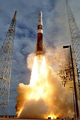
_liftes_off_with_goes-n.jpg)
Weather forecasting
Weather forecasting is the application of science and technology to predict the state of the atmosphere for a given location. Human beings have attempted to predict the weather informally for millennia, and formally since the nineteenth century...
, severe storm tracking, and meteorology
Meteorology
Meteorology is the interdisciplinary scientific study of the atmosphere. Studies in the field stretch back millennia, though significant progress in meteorology did not occur until the 18th century. The 19th century saw breakthroughs occur after observing networks developed across several countries...
research. Spacecraft
Spacecraft
A spacecraft or spaceship is a craft or machine designed for spaceflight. Spacecraft are used for a variety of purposes, including communications, earth observation, meteorology, navigation, planetary exploration and transportation of humans and cargo....
and ground-based elements of the system work together to provide a continuous stream of environmental
Natural environment
The natural environment encompasses all living and non-living things occurring naturally on Earth or some region thereof. It is an environment that encompasses the interaction of all living species....
data. The National Weather Service
National Weather Service
The National Weather Service , once known as the Weather Bureau, is one of the six scientific agencies that make up the National Oceanic and Atmospheric Administration of the United States government...
(NWS) uses the GOES system for its United States weather monitoring and forecasting operations, and scientific researchers use the data to better understand land, atmosphere, ocean, and climate interactions.
The GOES system uses geosynchronous satellite
Geosynchronous satellite
A geosynchronous Satellite is a satellite whose orbit on the Earth repeats regularly over points on the Earth over time. If such a satellite's orbit lies over the equator, the orbit is circular and its angular velocity is the same as the earth's, then it is called a geostationary satellite...
s which—since the launch of SMS-1 in 1974—have been a basic element of U.S. weather monitoring and forecasting.
Satellites

- GOES-11 is designated GOES-West, currently located at 135°W over the Pacific OceanPacific OceanThe Pacific Ocean is the largest of the Earth's oceanic divisions. It extends from the Arctic in the north to the Southern Ocean in the south, bounded by Asia and Australia in the west, and the Americas in the east.At 165.2 million square kilometres in area, this largest division of the World...
. - GOES-12 is designated GOES-South, currently located at 60°W .
- GOES-13 is designated GOES-East, currently located at 75°W. It provides most of the U.S. weather information.
- GOES 14GOES 14GOES 14, known as GOES-O prior to reaching its operational orbit, is an American weather satellite, which is part of the US National Oceanic and Atmospheric Administration 's Geostationary Operational Environmental Satellite...
was placed in orbit on 7 July 2009, underwent Post-Launch Testing until December 2009 and then was placed in on-orbit storage at 105° W.. - GOES 15GOES 15GOES 15, previously known as GOES-P, is an American weather satellite, which will form part of the Geostationary Operational Environmental Satellite system operated by the US National Oceanic and Atmospheric Administration. The spacecraft was constructed by Boeing, and is the last of three GOES...
was launched 4 March 2010. It has completed Post-Launch Testing and is in standby mode at 89.5° W .
Several GOES satellites are still in orbit, either inactive or re-purposed. GOES-3 is no longer used for weather operations, but is a critical part of the communication links between the United States and Amundsen-Scott South Pole Station
Amundsen-Scott South Pole Station
The Amundsen–Scott South Pole Station is the American scientific research station on the high plateau of Antarctica. This station is located at the southernmost place on the Earth, the Geographic South Pole, at an elevation of 2,835 meters above sea level.The original Amundsen-Scott Station was...
. Geostationary satellites cannot ordinarily be seen at all from the poles, but they require station keeping fuel to keep them stationary over the equator. When station keeping fuel runs out, solar and lunar perturbations increase the satellite's inclination so that its ground track begins to describe a figure-8 in the north-south direction. This usually ends the satellite's primary mission. But when the inclination is high enough, the satellite may begin to rise above the polar horizons at the extremes of the figure-8, as is the case for GOES-3. A nine-meter dish was constructed at the station, and communication with the satellite is currently possible for about five hours per day. Data rates are around 2.048 Mbit/s bi-directional under optimum conditions.
GOES-8 (GOES-East when it was in operation) is in a parking orbit, currently drifting about 4°W daily. It was decommissioned on April 1, 2003, and deactivated on May 5, 2004, after the failure of its propulsion system.
Communication was lost for 13 days to GOES-12 on December 4, 2007 when it performed a standard station-keeping maneuver. GOES-11 initially took "full disk" images to cover the lost data until a contingency plan could be implemented. On December 5, 2007, GOES-10 was moved from South America operations to temporarily replace GOES-12 as the GOES-EAST operational satellite. On 9 December, communication with GOES-10 was also temporarily lost, but communication was resumed via a backup antenna. GOES-12 was successfully reactivated and moved back to normal operation following a thrust maneuver on 17 December. The trouble was traced to a leaking thruster valve, which pushed the satellite incorrectly. Emergency procedures were executed to cut off the valve, and a redundant thruster was activated to restore the location of the satellite.
GOES-10 was decommissioned on December 2, 2009 and was boosted to a graveyard orbit
Graveyard orbit
A graveyard orbit, also called a supersynchronous orbit, junk orbit or disposal orbit, is an orbit significantly above synchronous orbit, where spacecraft are intentionally placed at the end of their operational life...
. It no longer had the fuel for required maneuvers to keep it on station. It joins GOES 8 and 9 which are already in graveyard orbits. With the cessation of GOES-10's duties, GOES-13 has replaced GOES-12 as "GOES-East". GOES-12 was then moved to 60W and resume South American duties for GOES-10.
Purpose
Designed to operate in geostationary orbitGeostationary orbit
A geostationary orbit is a geosynchronous orbit directly above the Earth's equator , with a period equal to the Earth's rotational period and an orbital eccentricity of approximately zero. An object in a geostationary orbit appears motionless, at a fixed position in the sky, to ground observers...
, 35,790 km (22,240 statute miles) above the earth, thereby remaining stationary with respect to a point on the ground, the advanced GOES I–M spacecraft continuously view the continental United States, neighboring environs of the Pacific and Atlantic Oceans, and Central
Central America
Central America is the central geographic region of the Americas. It is the southernmost, isthmian portion of the North American continent, which connects with South America on the southeast. When considered part of the unified continental model, it is considered a subcontinent...
, South America
South America
South America is a continent situated in the Western Hemisphere, mostly in the Southern Hemisphere, with a relatively small portion in the Northern Hemisphere. The continent is also considered a subcontinent of the Americas. It is bordered on the west by the Pacific Ocean and on the north and east...
and southern Canada
Canada
Canada is a North American country consisting of ten provinces and three territories. Located in the northern part of the continent, it extends from the Atlantic Ocean in the east to the Pacific Ocean in the west, and northward into the Arctic Ocean...
. The three-axis, body-stabilized spacecraft design enables the sensors to "stare" at the earth
Earth
Earth is the third planet from the Sun, and the densest and fifth-largest of the eight planets in the Solar System. It is also the largest of the Solar System's four terrestrial planets...
and thus more frequently image cloud
Cloud
A cloud is a visible mass of liquid droplets or frozen crystals made of water and/or various chemicals suspended in the atmosphere above the surface of a planetary body. They are also known as aerosols. Clouds in Earth's atmosphere are studied in the cloud physics branch of meteorology...
s, monitor earth's surface temperature and water vapour fields, and sound the atmosphere for its vertical thermal and vapor structures. Thus the evolution of atmospheric phenomena can be followed, ensuring real-time coverage of short-lived dynamic events, especially severe local storm
Storm
A storm is any disturbed state of an astronomical body's atmosphere, especially affecting its surface, and strongly implying severe weather...
s and tropical cyclone
Tropical cyclone
A tropical cyclone is a storm system characterized by a large low-pressure center and numerous thunderstorms that produce strong winds and heavy rain. Tropical cyclones strengthen when water evaporated from the ocean is released as the saturated air rises, resulting in condensation of water vapor...
s—two meteorological events that directly affect public safety, protection of property, and ultimately, economic health and development. The importance of this capability has been exemplified during hurricanes Hugo
Hurricane Hugo
Hurricane Hugo was a classical, destructive and rare Cape Verde-type hurricane which struck the Caribbean islands of Guadeloupe, Montserrat, St. Croix, Puerto Rico and the USA mainland in South Carolina as a Category 4 hurricane during September of the 1989 Atlantic hurricane season...
(1989) and Andrew
Hurricane Andrew
Hurricane Andrew was the third Category 5 hurricane to make landfall in the United States, after the Labor Day Hurricane of 1935 and Hurricane Camille in 1969. Andrew was the first named storm and only major hurricane of the otherwise inactive 1992 Atlantic hurricane season...
(1992).
The GOES I–M series of spacecraft are the principal observational platforms for covering such dynamic weather events and the near-earth space environment for the 1990s and into the 21st century. These advanced spacecraft enhance the capability of the GOES system to continuously observe and measure meteorological phenomena in real time, providing the meteorological community and atmospheric scientists
Meteorology
Meteorology is the interdisciplinary scientific study of the atmosphere. Studies in the field stretch back millennia, though significant progress in meteorology did not occur until the 18th century. The 19th century saw breakthroughs occur after observing networks developed across several countries...
greatly improved observational and measurement data of the Western Hemisphere
Western Hemisphere
The Western Hemisphere or western hemisphere is mainly used as a geographical term for the half of the Earth that lies west of the Prime Meridian and east of the Antimeridian , the other half being called the Eastern Hemisphere.In this sense, the western hemisphere consists of the western portions...
. In addition to short-term weather forecasting and space environmental monitoring, these enhanced operational services also improve support for atmospheric science research, numerical weather prediction
Numerical weather prediction
Numerical weather prediction uses mathematical models of the atmosphere and oceans to predict the weather based on current weather conditions. Though first attempted in the 1920s, it was not until the advent of computer simulation in the 1950s that numerical weather predictions produced realistic...
models, and environmental sensor design and development. Data is received via the NOAA Command and Data Acquisition ground station at Wallops Island, Virginia The GOES satellites are controlled from the Satellite Operations Control Center (SOCC) located in Suitland, Maryland. During significant weather or other events the normal schedules can be altered to provide coverage requested by the National Weather Service and other agencies.
Payload
The main mission is carried out by the primary payload instruments, the Imager and the Sounder. The Imager is a multichannel instrument that senses infrared radiant energyRadiant energy
Radiant energy is the energy of electromagnetic waves. The quantity of radiant energy may be calculated by integrating radiant flux with respect to time and, like all forms of energy, its SI unit is the joule. The term is used particularly when radiation is emitted by a source into the...
and visible reflected solar energy
Albedo
Albedo , or reflection coefficient, is the diffuse reflectivity or reflecting power of a surface. It is defined as the ratio of reflected radiation from the surface to incident radiation upon it...
from the Earth's surface and atmosphere. The Sounder provides data for vertical atmospheric temperature and moisture profiles, surface and cloud top temperature, and ozone
Ozone
Ozone , or trioxygen, is a triatomic molecule, consisting of three oxygen atoms. It is an allotrope of oxygen that is much less stable than the diatomic allotrope...
distribution.
Other instruments on board the spacecraft are the ground-based meteorological platform data collection and relay, and the space environment monitor. The latter consists of a magnetometer
Magnetometer
A magnetometer is a measuring instrument used to measure the strength or direction of a magnetic field either produced in the laboratory or existing in nature...
, an X-ray
X-ray
X-radiation is a form of electromagnetic radiation. X-rays have a wavelength in the range of 0.01 to 10 nanometers, corresponding to frequencies in the range 30 petahertz to 30 exahertz and energies in the range 120 eV to 120 keV. They are shorter in wavelength than UV rays and longer than gamma...
sensor, a high energy proton
Proton
The proton is a subatomic particle with the symbol or and a positive electric charge of 1 elementary charge. One or more protons are present in the nucleus of each atom, along with neutrons. The number of protons in each atom is its atomic number....
and alpha
Alpha particle
Alpha particles consist of two protons and two neutrons bound together into a particle identical to a helium nucleus, which is classically produced in the process of alpha decay, but may be produced also in other ways and given the same name...
detector, and an energetic particles sensor, all used for in-situ surveying of the near-earth space environment. Satellites numbered 12 and greater also carry a solar x-ray imager (SXI) used for two-dimensional imaging of the Sun. The GOES 13-15 series also have a sun-pointed extreme ultraviolet sensor.
Emergency Position-Indicating Radio Beacon
Distress radio beacons, also known as emergency beacons, ELT or EPIRB, are tracking transmitters which aid in the detection and location of boats, aircraft, and people in distress. Strictly, they are radiobeacons that interface with worldwide offered service of Cospas-Sarsat, the international...
(EPIRB) and Emergency Locator Transmitter (ELT) receivers, which are used for search-and-rescue
Search and rescue
Search and rescue is the search for and provision of aid to people who are in distress or imminent danger.The general field of search and rescue includes many specialty sub-fields, mostly based upon terrain considerations...
purposes by the U.S. Air Force Rescue Coordination Center
Air Force Rescue Coordination Center
As the United States' inland search and rescue coordinator, the Air Force Rescue Coordination Center serves as the single agency responsible for coordinating on-land federal SAR activities in the United States, including Puerto Rico and U.S. Virgin Islands.Some of the AFRCC's more notable...
.
Satellite designations
Before being launched, GOES satellites are designated by letters (-A, -B, -C...). Once a GOES satellite is launched successfully, it is redesignated with a number (-1, -2, -3...). So, GOES-A to GOES-F became GOES-1 to GOES-6. Because GOES-G was a launch failure, it never received a number. Since then, GOES-H to GOES-N became GOES-7 to GOES-13.The procurement, design and manufacturing of GOES is overseen by NASA
NASA
The National Aeronautics and Space Administration is the agency of the United States government that is responsible for the nation's civilian space program and for aeronautics and aerospace research...
, while all operations of the satellites once in orbit are done by NOAA. GOES spacecraft have been manufactured by Boeing
Boeing
The Boeing Company is an American multinational aerospace and defense corporation, founded in 1916 by William E. Boeing in Seattle, Washington. Boeing has expanded over the years, merging with McDonnell Douglas in 1997. Boeing Corporate headquarters has been in Chicago, Illinois since 2001...
(GOES D-H and N–P) and Space Systems/Loral
Space Systems/Loral
Space Systems/Loral , of Palo Alto, California, is the wholly owned manufacturing subsidiary of Loral Space & Communications. It was acquired in 1990 for $715 million by Loral Corp. from Ford Motor Company as the Space Systems Division of Ford Aerospace...
(A–C and I–M). The two current GOES series (I-M and N-P) are documented in the "GOES I–M Databook" and "GOES N Series Databook".
GOES-13
GOES 13
GOES 13, known as GOES-N before becoming operational, is an American weather satellite which is part of the US National Oceanic and Atmospheric Administration's Geostationary Operational Environmental Satellite system. It was launched in 2006...
(which was designated GOES-N prior to orbiting) was launched by a Delta IV rocket
Delta IV rocket
Delta IV is an active expendable launch system in the Delta rocket family. Delta IV uses rockets designed by Boeing's Integrated Defense Systems division and built in the United Launch Alliance facility in Decatur, Alabama. Final assembly is completed at the launch site by ULA...
from Space Launch Complex 37B at Cape Canaveral Air Force Station
Cape Canaveral Air Force Station
Cape Canaveral Air Force Station is an installation of the United States Air Force Space Command's 45th Space Wing, headquartered at nearby Patrick Air Force Base. Located on Cape Canaveral in the state of Florida, CCAFS is the primary launch head of America's Eastern Range with four launch pads...
in Florida
Florida
Florida is a state in the southeastern United States, located on the nation's Atlantic and Gulf coasts. It is bordered to the west by the Gulf of Mexico, to the north by Alabama and Georgia and to the east by the Atlantic Ocean. With a population of 18,801,310 as measured by the 2010 census, it...
at 22:11 GMT May 24, 2006. The launch of GOES-O was delayed several times due to various issues. GOES-O was launched Saturday, June 27, 2009 at 6:51 p.m. EDT from Florida
Florida
Florida is a state in the southeastern United States, located on the nation's Atlantic and Gulf coasts. It is bordered to the west by the Gulf of Mexico, to the north by Alabama and Georgia and to the east by the Atlantic Ocean. With a population of 18,801,310 as measured by the 2010 census, it...
's Cape Canaveral Air Force Station
Cape Canaveral Air Force Station
Cape Canaveral Air Force Station is an installation of the United States Air Force Space Command's 45th Space Wing, headquartered at nearby Patrick Air Force Base. Located on Cape Canaveral in the state of Florida, CCAFS is the primary launch head of America's Eastern Range with four launch pads...
at Space Launch Complex 37 piggybacking on a Delta IV rocket. The GOES-O satellite is a part of the GOES N Series, and was renamed as GOES-14 once it successfully arrived on orbit. GOES-14
GOES 14
GOES 14, known as GOES-O prior to reaching its operational orbit, is an American weather satellite, which is part of the US National Oceanic and Atmospheric Administration 's Geostationary Operational Environmental Satellite...
will be stored and will be able to be activated for duty if another GOES satellite is decommissioned. GOES-P launched successfully on March 4, 2010 at 18:57 EST. Boeing will build and launch a GOES-Q only if either GOES-O or GOES-P fails to be delivered on-orbit in good working order.
In October 2006, NOAA repositioned GOES-10 (originally GOES-K) over the Amazon region, to provide full time coverage for South American countries. Although NOAA currently sends images to South America, the frequency drops from 30-minutes to 3 hours whenever a storm occurs in North America, which is roughly 40% of the time during the hurricane season.
In addition, because GOES satellites have only been equipped with infrared
IR
Ir or ir may refer to:* the abbreviation for the title of Ingénieur , a person practicing the profession of engineering* Iridium , the 77th element* .ir, the Internet country code top-level domain for Iran...
sounders. This limits GOES to where its soundings will only work in cloud free areas.
Future
The GOES-R series of spacecraft is in the development phase. The first GOES-R series satellite is scheduled for launch in fiscal year 2015 and is expected to remain operational through December 2027. The proposed instrument package for the series initially included: the Advanced Baseline Imager (ABI); the Hyperspectral Environmental Suite (HES); the Space Environment In-Situ Suite (SEISS), which includes two Magnetospheric Particle Sensors (MPS-HI and MPS-LO), an Energetic Heavy Ion Sensor (EHIS), and a Solar and Galactic Proton Sensor (SGPS); the Solar Imaging Suite (SIS), which includes the Solar Ultraviolet Imager (SUVI), the Solar X-Ray Sensor (XRS), and the Extreme Ultraviolet Sensor (EUVS); the Geostationary Lightning Mapper (GLM); and the Magnetometer.In September 2006 the Hyperspectral Environmental Suite (HES) was canceled and the planned number of satellites was reduced from 4 to 2 by NOAA due to concerns about cost overruns. The planned delivery schedule was also slowed down in order to reduce costs. The expected cost is $
United States dollar
The United States dollar , also referred to as the American dollar, is the official currency of the United States of America. It is divided into 100 smaller units called cents or pennies....
7.69 billion—a $670 million increase from the prior $7 billion estimate.
The contract for the constructing the satellites themselves, as well as the magnetometer system, SUVI and GLM, was awarded to Lockheed Martin
Lockheed Martin
Lockheed Martin is an American global aerospace, defense, security, and advanced technology company with worldwide interests. It was formed by the merger of Lockheed Corporation with Martin Marietta in March 1995. It is headquartered in Bethesda, Maryland, in the Washington Metropolitan Area....
. The award was challenged by Boeing
Boeing
The Boeing Company is an American multinational aerospace and defense corporation, founded in 1916 by William E. Boeing in Seattle, Washington. Boeing has expanded over the years, merging with McDonnell Douglas in 1997. Boeing Corporate headquarters has been in Chicago, Illinois since 2001...
, who lost the bid; however, the protest was subsequently dismissed. The ABI will be delivered by ITT Exelis
ITT Corporation
ITT Corporation is a global diversified manufacturing company based in the United States. ITT participates in global markets including water and fluids management, defense and security, and motion and flow control...
. The SEISS will be delivered by Assurance Technology Corporation. XRS and EUVS will be combined into the Extreme Ultra Violet and X-Ray Irradiance Sensors (EXIS) which will be delivered by the Laboratory for Atmospheric and Space Physics of the University of Colorado.
The contract for the ground system (including data processing) was awarded to a team led by the Weather Systems division of Harris Corporation
Harris Corporation
Harris Corporation is a Florida-based international communications equipment company that produces wireless equipment, electronic systems, and both terrestrial and spaceborne antennas for use in the government, defense, and commercial sectors. It is also the largest private-sector employer in...
, including subcontracts to Boeing, Atmospheric and Environmental Research (AER), Honeywell
Honeywell
Honeywell International, Inc. is a major conglomerate company that produces a variety of consumer products, engineering services, and aerospace systems for a wide variety of customers, from private consumers to major corporations and governments....
, Carr Astronautics, Wyle Laboratories
Wyle Laboratories
Wyle is a privately held provider of specialized engineering, scientific and technical services to the Department of Defense, NASA, and a variety of commercial customers primarily in the aerospace industry...
, and Ares
Ares Incorporated
ARES Incorporated is weapons manufacturer co-founded by Eugene Stoner in 1971. The company is based in Port Clinton, Ohio, and produces fire control systems, turret systems, small arms, automatic cannons and industrial machinery....
.
History/status of GOES satellites
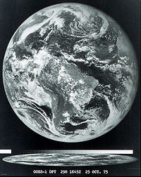
- GOES 1GOES 1GOES 1, designated GOES-A and SMS-C prior to entering service, was a weather satellite operated by the United States National Oceanic and Atmospheric Administration. It was the first Geostationary Operational Environmental Satellite to be launched....
, launched on October 16, 1975, decommissioned - GOES 2GOES 2GOES 2, known as GOES-B before becoming operational, was a geostationary weather satellite which was operated by the United States National Oceanic and Atmospheric Administration as part of the Geostationary Operational Environmental Satellite system...
, launched on June 16, 1977, decommissioned - GOES 3GOES 3GOES 3, known as GOES-C before becoming operational, is an American geostationary weather and communications satellite. It was originally built for the National Oceanic and Atmospheric Administration as part of the Geostationary Operational Environmental Satellite system, and was launched in June...
, launched on June 16, 1978, used as a communications relay for the South Pole research station. - GOES 4GOES 4GOES 4, known as GOES-D before becoming operational, was a geostationary weather satellite which was operated by the United States National Oceanic and Atmospheric Administration as part of the Geostationary Operational Environmental Satellite system. Launched in 1980, it was used for weather...
, launched on September 9, 1980, decommissioned - GOES 5GOES 5GOES 5, known as GOES-E before becoming operational, was a geostationary weather satellite which was operated by the United States National Oceanic and Atmospheric Administration as part of the Geostationary Operational Environmental Satellite system...
, launched on May 22, 1981, deactivated on July 18, 1990 - GOES 6GOES 6GOES 6, known as GOES-F before becoming operational, was a geostationary weather satellite which was operated by the United States National Oceanic and Atmospheric Administration as part of the Geostationary Operational Environmental Satellite system...
, launched on April 28, 1983, decommissioned - GOES-G, launched on May 3, 1986, failed to orbit
- GOES 7GOES 7GOES 7, known as GOES-H before becoming operational, is an American satellite. It was originally built as a weather satellite, and formed part of the US National Oceanic and Atmospheric Administration's Geostationary Operational Environmental Satellite system. Originally built as a ground spare,...
, launched April 28, 1987, used as a communications satellite by Peacesat - GOES 8GOES 8GOES 8, known as GOES-I before becoming operational, was an American weather satellite, which formed part of the US National Oceanic and Atmospheric Administration's Geostationary Operational Environmental Satellite system. It was launched in 1994, and operated until 2004 when it was retired and...
, launched on April 13, 1994, decommissioned - GOES 9GOES 9GOES 9, known as GOES-J before becoming operational, was an American weather satellite, which formed part of the US National Oceanic and Atmospheric Administration's Geostationary Operational Environmental Satellite system. It was launched in 1995, and operated until 2007 when it was retired and...
, launched on May 23, 1995, decommissioned on June 15, 2007 - GOES 10GOES 10GOES 10, known as GOES-K before becoming operational, was an American weather satellite, which formed part of the US National Oceanic and Atmospheric Administration's Geostationary Operational Environmental Satellite system...
, launched on April 25, 1997, decommissioned on December 2, 2009 - GOES 11GOES 11GOES 11, known as GOES-L before becoming operational, is an American weather satellite, which is part of the US National Oceanic and Atmospheric Administration's Geostationary Operational Environmental Satellite system...
, launched on May 3, 2000, in operation as GOES West - GOES 12GOES 12GOES 12, known as GOES-M before becoming operational is an American weather satellite, which is part of the US National Oceanic and Atmospheric Administration's Geostationary Operational Environmental Satellite system. It was launched in 2001, and it is in standby orbit...
, launched on July 23, 2001, standby, providing coverage for South America - GOES 13GOES 13GOES 13, known as GOES-N before becoming operational, is an American weather satellite which is part of the US National Oceanic and Atmospheric Administration's Geostationary Operational Environmental Satellite system. It was launched in 2006...
, launched on May 24, 2006, in operation as GOES East - GOES 14GOES 14GOES 14, known as GOES-O prior to reaching its operational orbit, is an American weather satellite, which is part of the US National Oceanic and Atmospheric Administration 's Geostationary Operational Environmental Satellite...
, launched on June 27, 2009, on orbit - in storage, will replace GOES-11 in the Fall of 2011 - GOES 15GOES 15GOES 15, previously known as GOES-P, is an American weather satellite, which will form part of the Geostationary Operational Environmental Satellite system operated by the US National Oceanic and Atmospheric Administration. The spacecraft was constructed by Boeing, and is the last of three GOES...
, launched on March 4, 2010 on orbit - testing complete, currently in standby - GOES R, scheduled for launch in 2015
- GOES S, scheduled for launch in 2016
See also
- Applications Technology SatellitesApplications Technology SatellitesThe Applications Technology Satellites were a series of experimental satellites launched by NASA. The program was launched in 1966 to test the feasibility of placing a satellite into the geosynchronous orbit. The satellites were primarily designed to act as communication satellites, but also...
- six early geosynchronous satellites that carried communications, meteorology and navigation payloads - Emergency position-indicating radio beacon
- MTSATMulti-Functional Transport SatelliteMultifunctional Transport Satellites are a series of weather and aviation control satellites. They are geostationary satellites owned and operated by the Japanese Ministry of Land, Infrastructure and Transport and the Japan Meteorological Agency , and provide coverage for the hemisphere centred on...
, JapanJapanJapan is an island nation in East Asia. Located in the Pacific Ocean, it lies to the east of the Sea of Japan, China, North Korea, South Korea and Russia, stretching from the Sea of Okhotsk in the north to the East China Sea and Taiwan in the south...
ese weather satellite program - Polar Operational Environmental SatellitesPolar Operational Environmental SatellitesThe Polar Operational Environmental Satellite project operates a constellation of weather satellites in polar orbits around the Earth. It is a joint effort between the National Oceanic and Atmospheric Administration and the European Organisation for the Exploitation of Meteorological Satellites...
- Remote sensingRemote sensingRemote sensing is the acquisition of information about an object or phenomenon, without making physical contact with the object. In modern usage, the term generally refers to the use of aerial sensor technologies to detect and classify objects on Earth by means of propagated signals Remote sensing...
Further reading
External links
- National Weather Service Satellite Images (current plus 3,6,12 and 24 hr loops)
- GOES Operations on NOAA website
- GOES-R article
- LM/SAIC/IBM partnership announced for GOES
- GOES gallery
- GOES weather satellite viewer Online GOES East and GOES West weather satellite viewer with 2 months of archived data.
- Social & Economic Benefits of GOES from "NOAA Socioeconomics" website initiative
- Introduction to satellite imagery
- Spherical panorama of GOES-O in the clean room