

Geography of the Maldives
Encyclopedia
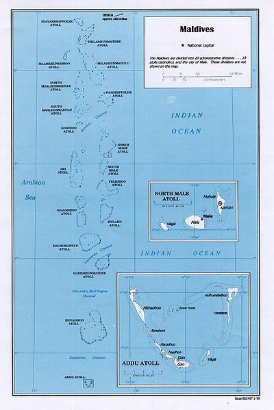
- See also Atolls of the MaldivesAtolls of the MaldivesThe Maldives are formed by a number of natural atolls plus atolls in the form of a few islands and isolated reefs today which form a pattern stretching from 7 degrees 10' North to 0 degrees 45' South....
for an in-depth description of the atolls.
Maldives
Maldives
The Maldives , , officially Republic of Maldives , also referred to as the Maldive Islands, is an island nation in the Indian Ocean formed by a double chain of twenty-six atolls oriented north-south off India's Lakshadweep islands, between Minicoy Island and...
is a country of South Asia
South Asia
South Asia, also known as Southern Asia, is the southern region of the Asian continent, which comprises the sub-Himalayan countries and, for some authorities , also includes the adjoining countries to the west and the east...
, situated in the Indian Ocean
Indian Ocean
The Indian Ocean is the third largest of the world's oceanic divisions, covering approximately 20% of the water on the Earth's surface. It is bounded on the north by the Indian Subcontinent and Arabian Peninsula ; on the west by eastern Africa; on the east by Indochina, the Sunda Islands, and...
, south-southwest of India
India
India , officially the Republic of India , is a country in South Asia. It is the seventh-largest country by geographical area, the second-most populous country with over 1.2 billion people, and the most populous democracy in the world...
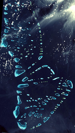
. It consists of approximately 1,190 coral island
Island
An island or isle is any piece of sub-continental land that is surrounded by water. Very small islands such as emergent land features on atolls can be called islets, cays or keys. An island in a river or lake may be called an eyot , or holm...
s grouped in a double chain of 26 atoll
Atoll
An atoll is a coral island that encircles a lagoon partially or completely.- Usage :The word atoll comes from the Dhivehi word atholhu OED...
s, spread over roughly 90,000 square kilometers, making this one of the most disparate countries in the world. Composed of live coral reef
Coral reef
Coral reefs are underwater structures made from calcium carbonate secreted by corals. Coral reefs are colonies of tiny living animals found in marine waters that contain few nutrients. Most coral reefs are built from stony corals, which in turn consist of polyps that cluster in groups. The polyps...
s and sand bars, the atolls are situated atop a submarine ridge 960 kilometers long that rises abruptly from the depths of the Indian Ocean
Indian Ocean
The Indian Ocean is the third largest of the world's oceanic divisions, covering approximately 20% of the water on the Earth's surface. It is bounded on the north by the Indian Subcontinent and Arabian Peninsula ; on the west by eastern Africa; on the east by Indochina, the Sunda Islands, and...
and runs from north to south. Only near the southern end of this natural coral barricade do two open passages permit safe ship navigation from one side of the Indian Ocean to the other through the territorial waters of Maldives. For administrative purposes the Maldives government organized these atolls into nineteen administrative divisions
Administrative divisions of the Maldives
The Administrative Divisions of the Maldives refers to the various units of government that provide local government services in the Maldives. According to the Decentralization Act 2010, the administrative divisions of the Maldives would consist of atolls, islands, and cities; each administered by...
.
The largest island of Maldives is Gan
Gan
Gan may refer to:-Computing and telecommunications:*.gan, the file extension for documents created by GanttProject*Generic Access Network formerly known as Unlicensed Mobile Access *Global Area Network- Mythology :...
, which belongs to Laamu Atoll or Hahdhummathi Maldives. In Addu Atoll
Addu Atoll
Addu City is a city in Maldives consisting of the inhabited islands of the southernmost atoll of the archipelago....
the westernmost islands are connected by roads over the reef and the total length of the road is 14 km.
Geographic coordinates: 3°15′N 73°00′E
Physical Geography

Atolls of the Maldives
The Maldives are formed by a number of natural atolls plus atolls in the form of a few islands and isolated reefs today which form a pattern stretching from 7 degrees 10' North to 0 degrees 45' South....
consist of a large, ring-shaped coral reef
Coral reef
Coral reefs are underwater structures made from calcium carbonate secreted by corals. Coral reefs are colonies of tiny living animals found in marine waters that contain few nutrients. Most coral reefs are built from stony corals, which in turn consist of polyps that cluster in groups. The polyps...
supporting numerous small islands. Islands average only one to two square kilometers in area, and lie between one and 1.5 meters above mean sea level. Although some of the larger atolls are approximately 50 kilometers long from north to south, and 30 kilometers wide from east to west, no individual island is longer than eight kilometers.
Maldives has no hills, but some islands have dunes which can reach 2.4 meters / 8 feet above sea level, like the NW coast of Hithadhoo (Seenu Atoll)
Hithadhoo (Seenu Atoll)
Hithaadhoo is a district of Addu City, in the Maldives. Hithadhoo is the main administrative district of Addu City, with many of the administrative buildings in this district. The town is situated on the island of the same name, the westernmost of Seenu...
in Addu Atoll
Addu Atoll
Addu City is a city in Maldives consisting of the inhabited islands of the southernmost atoll of the archipelago....
. Islands are too small to have rivers, but small lakes and marshes can be found in some islands.
On average, each atoll has approximately 5 to 10 inhabited islands; the uninhabited islands of each atoll number approximately 20 to 60. Some atolls, however, consist of one large, isolated island surrounded by a steep coral beach. The most notable example of this type of atoll is the large island of Fuvahmulah situated in the Equatorial Channel.
The tropical vegetation of Maldives differs in the inhabited and in the uninhabited islands. Inhabited islands have small groves of banana, papaya, drumstick and citrus trees by the homesteads, while breadfruit trees and coconut palms are grown in available patches of land. On the other hand uninhabited islands have mostly different kinds of bushes (magū, kuredi, kandū, boshi) along the waterline as well as some coconut trees.
Some islands are marshy, while others are higher owing to sand and gravel having been piled up by wave action. Often the soil is highly alkaline, and a deficiency in nitrogen, potash, and iron severely limits agricultural potential. Ten percent of the land, or about 26 km², is cultivated with taro, bananas, coconuts, and other fruit. Only the lush island of Fuvammulah produces fruits such as oranges and pineapples partly because the terrain of Fuvammulah is higher than most other islands, leaving the groundwater less subject to seawater penetration. However, as population grows, even in this island the cultivated areas are shrinking rapidly.
Freshwater floats in a layer known as "Ghyben/Herzberg lens" above the seawater that permeates the limestone and coral sands of the islands. These lenses are shrinking rapidly on Male and on many islands where there are resorts catering to foreign tourists. Mango trees already have been reported dying on Male because of salt penetration. Most residents of the atolls depend on groundwater or rainwater for drinking purposes.
Climate

The weather in Maldives is affected by the large landmass of the South Asia to the north. The presence of this landmass causes differential heating of land and water. Scientists also cite other factors in the formation of monsoons, including the barrier of the Himalayas on the northern fringe of the South Asia and the sun's northward tilt, which shifts the jet stream north. These factors set off a rush of moisture-rich air from the Indian Ocean over the South Asia, resulting in the southwest monsoon. The hot air that rises over the South Asia during April and May creates low-pressure areas into which the cooler, moisture-bearing winds from the Indian Ocean flow. In Maldives, the wet southwest monsoon lasts from the end of April to the end of October and brings the worst weather with strong winds and storms. In May 1991 violent monsoon winds created tidal waves that damaged thousands of houses and piers, flooded arable land with seawater, and uprooted thousands of fruit trees. The damage caused was estimated at US$30 million.
The shift from the moist southwest monsoon to the dry northeast monsoon over the South Asia occurs during October and November. During this period, the northeast winds contribute to the formation of the northeast monsoon, which reaches Maldives in the beginning of December and lasts until the end of March. However, the weather patterns of Maldives do not always conform to the monsoon patterns of the South Asia. Rain showers over the whole country have been known to persist for up to one week during the midst of the dry season.
Area and boundaries
total:
300 km²
land:
300 km²
water:
0 km²
Coastline:
644 km
Maritime claims:
measured from claimed archipelagic baselines
contiguous zone:
24 nmi (44.4 km; 27.6 mi)
exclusive economic zone:
200 nmi (370.4 km; 230.2 mi)
territorial sea:
12 nmi (22.2 km; 13.8 mi)
Elevation extremes:
lowest point:
Indian Ocean 0 m
highest point:
unnamed location on Vilingili Island in the Addu Atoll
Addu Atoll
Addu City is a city in Maldives consisting of the inhabited islands of the southernmost atoll of the archipelago....
2.4 m (Maldives is the flattest country in the world, i.e. they have the lowest high-point of any country in the world).
Resources and land use
Natural resources:fish
Land use:
arable land:
13.33%
permanent crops:
30%
permanent pastures:
3%
forests and woodland:
3%
other:
51% (1993 est.)
Irrigated land:
NA
Environmental concerns
Natural hazards:low level of islands makes them very sensitive to sea level rise.
Some scientists fear it could be underwater by 2050 or 2100. The UN's environmental panel has warned that, at current rates, sea level would be high enough to make the country uninhabitable by 2100.
President Mohamed Nasheed
Mohamed Nasheed
Mohamed Nasheed is a Maldivian politician. He is the current President of the Maldives. He is the founder of the Maldivian Democratic Party and was its presidential candidate in the October 2008 presidential election, defeating long-time President Maumoon Abdul Gayoom in a second round of voting...
aims to turn the Maldives into an entirely carbon neutral nation by 2020.
Environment - current issues:
depletion of freshwater aquifers threatens water supplies, global warming and sea level rise, coral reef bleaching, overpopulation, deforestation, and air pollution
Environment - international agreements:
Biodiversity, Climate Change, Climate Change-Kyoto Protocol, Desertification, Hazardous Wastes, Ozone Layer Protection, Law of the Sea
Statistics
- Position: degree of latitudeLatitudeIn geography, the latitude of a location on the Earth is the angular distance of that location south or north of the Equator. The latitude is an angle, and is usually measured in degrees . The equator has a latitude of 0°, the North pole has a latitude of 90° north , and the South pole has a...
: 07° 06'30" N to 00° 41'48" S and degree of longitudeLongitudeLongitude is a geographic coordinate that specifies the east-west position of a point on the Earth's surface. It is an angular measurement, usually expressed in degrees, minutes and seconds, and denoted by the Greek letter lambda ....
: 72° 32'30" E to 73° 45'54" E westside of India and Sri Lanka. - Range: in length approx. 750 km (from north to south) / in width approx. 120 km (from west to east)
- Land territory: 1,196 mostly deserted islands with a total area of approx. 298 km².
- The islands are in average 1.8 m above sea level.
- Distances: shortest distance to India: approx. 340 km and to Sri Lanka approx. 700 km.