

Atolls of the Maldives
Encyclopedia
- This article discusses the natural geographical atolls of the Maldives. See Administrative divisions of the MaldivesAdministrative divisions of the MaldivesThe Administrative Divisions of the Maldives refers to the various units of government that provide local government services in the Maldives. According to the Decentralization Act 2010, the administrative divisions of the Maldives would consist of atolls, islands, and cities; each administered by...
for the administrative units also known as atolls. See Islands of the Maldives for individual islands that make up the archipelago.
The Maldives
Maldives
The Maldives , , officially Republic of Maldives , also referred to as the Maldive Islands, is an island nation in the Indian Ocean formed by a double chain of twenty-six atolls oriented north-south off India's Lakshadweep islands, between Minicoy Island and...
are formed by a number of natural atolls plus atolls in the form of a few islands and isolated reefs today which form a pattern stretching from 7 degrees 10' North to 0 degrees 45' South.
The Maldives is a long and narrow country formed by 26 natural atolls. Some atolls are in the form of a number of islands by time and in the form of isolated reefs, which could be classified as smaller atoll formations. All land above the surface in the Maldives is of coral
Coral
Corals are marine animals in class Anthozoa of phylum Cnidaria typically living in compact colonies of many identical individual "polyps". The group includes the important reef builders that inhabit tropical oceans and secrete calcium carbonate to form a hard skeleton.A coral "head" is a colony of...
line origin.
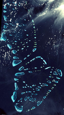
The atolls of the Maldives form a quite regular chain and, especially in the northern and central atolls, an arrayed structure is apparent. There are broad and deep channels in between some atolls.
The origin of the word atoll itself is in the language of the Maldives. 'Atoll' (from Dhivehi
Dhivehi language
Maldivian is an Indo-Aryan language predominantly spoken by about 350,000 people in the Maldives where it is the national language. It is also the first language of nearly 10,000 people in the island of Minicoy in the Union territory of Lakshadweep, India where the Mahl dialect of the Maldivian...
'atholhu') is now used in many languages worldwide.
Traditionally, Maldivians call the atolls ending in '-madulu' or '-mathi' by their name without adding the word 'Atoll' at the end. For example, it is correct to write simply Kolhumadulhu
Kolhumadulhu Atoll
Kolhumadulu Atoll or Thaa is an is an administrative division of the Maldives. It corresponds to the natural atoll of the same name.Traditionally, Maldivians call this atoll simply 'Kolhumadulu', without adding the word 'Atholhu' at the end....
, without adding the word 'Atholhu' at the end. This is also the case in the atoll known as Faadhippolhu
Faadhippolhu Atoll
Faadhippolhu Atoll is an administrative division of the Maldives. It corresponds to the natural atoll of the same name.There is an industrial island with tuna canning facilities located at Felivaru....
.
The atolls of the Maldives are very complex structures and formerly they were very dangerous for navigators. In 1834-36 British Captain Robert Moresby
Robert Moresby
Robert Moresby was a distinguished captain of the British Royal Navy. He was also an excellent hydrographer, maritime surveyor and draughtsman....
undertook the laborious and difficult cartography of the Maldive Islands, drawing the first accurate maritime charts of this complicated Indian Ocean atoll group.
These Admiralty chart
Admiralty chart
Admiralty charts are nautical charts issued by the United Kingdom Hydrographic Office and subject to Crown Copyright. Over 3,000 charts are available and cover virtually the entire world in various levels of detail depending on the density of traffic and hazards...
s were printed as three separate large maps by the Hydrographic Service of the Royal Navy. Although they contain a few errors, Moresby's charts were so good that they were favoured by Maldivian pilots navigating through the treacherous waters of their atolls until the 1990s.
Nowadays there are more accurate maps of the Maldives based on satellite surveys. However, Maldivian navigators still claim that Commander Moresby's charts provide a wealth of data that the modern maps don't give. At the time that they were drawn, the maps of the Maldives were deemed of such a high quality that they were inspected personally by Queen Victoria.
Owing to the many beautiful diving grounds of the numerous atolls of the Maldives, this country has been marketed as a prime destination for scuba divers worldwide.
Hence, during the last couple of decades many guides and maps of the best diving spots have been published and some of them are very accurate and give a wide array of useful hints.
Atolls of the Maldives: Physical Description
The list below is a description of the geographic atolls of the Maldives.Ihavandhippolhu
Ihavandhippolhu Atoll is the northernmost atoll in the Maldives. It is a small natural atoll 22 km in length. It has 25 islands lying all around the boundary reef. One long barrier reef forms the western side of the atoll. There are several coral patches in the lagoon and the general depth in the centre is 20 to 30 fathoms (35 to 55 m). Ihavandhippolhu is bounded in the north by the broad channel known as Māmalē Kandu (or Maliku Kandu)Maliku Kandu
Maliku Kandu and Māmalē Kandu Divehi are the traditional names of the broad Minicoy Channel between Minicoy and Ihavandippolhu in the north of the Maldives...
which separates the islands of Maldives from those belonging to India.
Thiladhunmathi
Thiladhunmati Atoll (Tiladummati in the Admiralty Charts) is a very open, atypical atoll without a clearly delimited lagoon. It stretches SSW for 76 km and contains nearly forty islands generally of a fair size. Kelaa, a large island forms a prominent point in the NE of this atoll. The western boundary has fewer islands but more isolated reefs or micro-atolls (faru), with wide passages between them. The German explorer Hans HassHans Hass
Hans Hass is a diving pioneer known mainly for his documentaries about sharks, the energon theory, and his commitment, later in life, to the protection of the environment. He was born in Vienna, Austria.-Early years:...
observed the formation of this phenomenon called 'micro-atoll' by Porites corals in the Maldives. Faru is the Dhivehi word for these reef structures. Its lagoon has few shoals, but many large faru, often topped with islands; the average depth is from 24 to 18 fathom
Fathom
A fathom is a unit of length in the imperial and the U.S. customary systems, used especially for measuring the depth of water.There are 2 yards in an imperial or U.S. fathom...
s (44 to 33 m).
The Miladummadulu group is also naturally a part of Thiladhunmati Atoll. This part’s length is 81 km and it contains 101 islands. The general depth of the centre of this part is 20 to 25 fathoms (37 to 46 m) and the bottom is sandy. Along its western edges there are not many islands, but more detached reefs with shallow lagoons (vilu) which seldom exceed 10 fathoms (18 m) in depth. Vilu is the Dhivehi word for these lovely shallow lagoons.
Maamakunudhoo
Māmakunudhoo Atoll or MakunudhooMakunudhoo
Makunudhoo as a place name may refer to:* Makunudhoo * Makunudhoo...
(Malcolm Atoll in the Admiralty Chart) is the westernmost atoll in the Maldives. A large reef with lagoon, 27 km long with and average breadth of 5 km. It has only one inhabited island , Makunudhoo and three other islands (namely Innafushi, Fenboahuraa and Edipparufushi) and it lies 15 km west of the NW part of the Miladhummadulhu group. It is said to have been unknown to non-Maldivians previous to the 1834-36 survey of the Maldives. According to the locals, many ships have been lost on its barren reefs with crew, cargo and all. These include the Persia Merchant (August, 1658), Hayston (July, 1891), George Reid (September, 1872) and many more. Owing to the violence of the surf and the perpendicular sides of the reef scarcely a vestige of the wreck remains after a few hours. The lagoon is quite deep but it is full of coral patches.
Etthingili Alifushi Atoll
Etthingili Alifushi Atoll compromise of the two islands, Alifushi and Etthingili (also known as Kalhifushi), known as 'The Powell Islands' in the Admiralty Chart. The islands stand on a detached reef of their own with very deep waters (no sounding) between this reef and the northern end of the main Atoll. The length of this atoll is 2 miles with a width of 1 mile. Today, from the two islands only Alifushi is inhabited.Maalhosmadulu Uthuruburi
Fasdhūetherē (Fasdhūtherē)
Fasdhūtherē Atoll. Sandwiched between two atolls, the northern part of South Maalhosmadulu forms a clearly delimited, roughly triangular, natural atoll without a distinctive name (Fasdhūtherē merely means 'between five islands'). It is 22 km in length from east to west. It has 11 islands with the only inhabited island being Kudarikilu Island on its SE corner just opposite Landaa-Giraavaru Island of Southern Maalhosmadulhu Atoll. Its lagoon becomes narrower towards the west and its average depth is 19 fathoms (35 m). It is separated from North Maalhosmadulhu by a deep channel (known as MoresbyRobert Moresby
Robert Moresby was a distinguished captain of the British Royal Navy. He was also an excellent hydrographer, maritime surveyor and draughtsman....
Channel in the Admiralty Chart and Hani Kandu locally) and from the southern part of South Maalhosmadulhu by the narrow Geydhoshu Kandu (also known as Ge'aa'badhigedheytherey Kandu) running from east to west.
Maalhosmadulu Dhekunuburi
Maalhosmadulu Dhekunuburi (Southern Maalhosmadulu Atoll) also known as has many large farus on its western side. Its maximum length is 48 km. The inner lagoons (vilu) present an idyllic view. The depth of their waters is not more than a few meters, with perhaps a few coral heads awash. Its eastern fringe is a succession of separate, quite regular, oval reefs with some islands. The interior of the lagoon has also large faru towards its southern half. The average depth is from 24 to 27 fathoms (44 to 49 m).Goidhu Atoll
Goidhu Atoll or Goifulhafehendhu Atoll ( 'Horsburgh Atoll' in the Admiralty Chart) is separated from South Maalhosmadulhu by a 10 km broad channel. This atoll is oval in shape and small, its greatest length being 15.5 km. It is composed of 7 islands, 3 of which are inhabited. The inner lagoon has a depth of 17 to 20 fathoms (31 to 37 m); it has a sandy bottom mixed with mud and clay. Unlike the lagoons of most small atolls of the Maldives, this lagoon is free from coral heads in its centre.Faadhippolhu
Faadhippolhu Atoll is a smaller atoll with a well-defined barrier reef to the east, on which the NE monsoon (iruvai) breaks with violence. Its western side has farus and reef patches. There are about 52 islands, of which only 5 are inhabited.The lagoon is fairly open and its general depths are from 25 to 30 fathoms (about 50 m). Its bottom is sandy and there are a number of coral patches and sunken reefs dotting it, except for the south-eastern side.
Kaashidhu Atoll
Kaashidhu Atoll, lies towards the eastern end of the channel to which it gives its name ('Kardiva ChannelKardiva Channel
Kardiva Channel is a broad channel running from southwest to northeast and cutting across the Maldive atoll chain. This channel divides the Northern from the Central atolls of the Maldives....
' in the Admiralty Chart). This atoll had two islands namely Kaashidhoo
Kaashidhoo
Kaashidhoo as a place name may refer to:* Kaashidhoo * Kaashidhoo...
and Kaashidhoo Huraa from which only Kaashidhoo
Kaashidhoo
Kaashidhoo as a place name may refer to:* Kaashidhoo * Kaashidhoo...
exists today. Kaashidhoo
Kaashidhoo
Kaashidhoo as a place name may refer to:* Kaashidhoo * Kaashidhoo...
is surrounded by deep waters and there is generally heavy surf all around. The Atoll has an oval-shaped lagoon (vilu) with a narrow fringing reef on its NW side.
Gahaafaru (Gaafaru) Atoll
Gahaafaru Atoll also known as Gaafaru Atoll or Gaafarufalhu is a small atoll at the eastern end of a large elliptical reef that has proved disastrous to many vessels with the wrecks of Aracan (1873), SS Seagull (1879), Clan Alpine (1879), Erlangen (1894), Crusader (1905) and Lady Cristine (1974). 15 km long and 8.5 km wide Gaafaru reef is as much a separate atoll as Goidu or Rasdhu which are similar in structure and size. It is separated from Malé Atoll by a narrow but deep Gaafaru Kandu channel. Its lagoon has an average depth of 16 fathoms and has no coral patches or shoals in its centre.Male'atholhu Uthutuburi
Male'atholhu Uthutuburi also known as North Malé Atoll is of irregular shape. It is 58 km long and contains about 50 islands (including the capital Malé). There are also sandbanks, coral patches, innumerable farus and submerged shoals (called "haa" in DhivehiDhivehi language
Maldivian is an Indo-Aryan language predominantly spoken by about 350,000 people in the Maldives where it is the national language. It is also the first language of nearly 10,000 people in the island of Minicoy in the Union territory of Lakshadweep, India where the Mahl dialect of the Maldivian...
). The general depths of the interior are between 25 and 35 fathoms (46 to 64 m). The bottom is sandy. There are numerous passages on all sides. Seen from space it is considered one of the most beautiful atolls on the planet.
Male'atholhu Dhekunuburi
Male'atholhu Dhekunuburi also known as South Malé Atoll is separated from North Malé Atoll by a deep channel (Vaadhu Kandu). Oblong in shape, this atoll is 35 km in length. It contains 22 islands, all except for 5 are situated in its eastern fringes. Inside this atoll there are also many reefs and little coral patches which make navigation difficult. The general depths of the lagoon are from 25 to 32 fathoms (46 to 59 m), sandy bottom. South of the atoll lies the deep Fulidhoo Kandu.Thoddu Atoll
Thoddu Atoll is a solitary round-shaped atoll located in deep waters at the western entrance of the Kardiva Channel. Its reef is steep and it lacks a lagoon.Rasdhu Atoll
Rasdhu Atoll also known as Rasdhukuramathi Atoll ('Ross Atoll' in the Admiralty Chart) is a small atoll with an almost round lagoon. It is located almost 8 km from the NE point of Ari Atoll. The northern and western sides are one continuous barrier reef, and the eastern side is another. The 7 km wide lagoon has soundings from 15 to 20 fathoms (27 ot 37 m) and abounds in detached coral patches.Ari Atoll
Ari Atoll is the second westernmost atoll of the Maldives, only after Maamakunudhoo Atoll. It is oblong in shape, 89 km in length by only 31 km in breadth. It contains some 50 islands, generally small, which lie mainly along its eastern fringe. Its features are intermediate between Maalhosmadulhu and North Malé atolls. Except for a small barrier reef in its southern end, it is shaped by a succession of large, separate oval reefs, like the large atolls in the North, with a clear rim of large faru to the east. In the interior the general soundings are 30 to 40 fathoms (55 to 73 m), with mud and sand. In places its lagoon contains small reef-patches, but it is generally dotted with many large coral reefs, some of which remain submerged even at low tide.Felidhe Atoll
Felidhe Atoll has a very irregular outline; it is surrounded by continuous barrier reefs, or by small patches with vilu separated by narrow passages. Felidhu AtollFelidhu Atoll
Felidhu Atoll is a natural atoll of the Maldives.It is the smallest administrative atoll in terms of population.This atoll is located 40 miles from capital Malé, 90 minutes by speedboat and 5 hours by slow boat....
has only 10 islands even though it is quite large. The Atoll’s western “horn” is devoid of islands and almost completely enclosed. Its eastern cape (Fottheyo Muli) is the easternmost geographical point of the Maldives. Both this cape and the westernmost point of this atoll (Fussaru) are dangerous for local navigation. Many ships plying along the route between Malé and the Southern Atolls, have been lost in these treacherous reefs. The distance between both points is 57 km. The inner lagoon is open with few reefs or shoals. Its general depth is of 40 fathoms (73 m); hard bottom of sand.
Vattaru Atoll (Falhu)
Vattaru Atoll (Falhu) is an egg-shaped reef or small atoll about 8.5 km in length. It has only one small uninhabited bushy islet close to its only entrance in the south. The depth of its inner lagoon is between 12 and 20 fathoms (22 to 37 m) and its bottom is sandy.Mulaku Atoll
Mulaku Atoll is a very shut-in atoll with an open lagoon surrounded by barrier reefs which are remarkably straight and broad in its western fringe. It is separated from the other Maldive atolls by the channels Vattaru Kandu in the north, Kudahuvadhoo Kandu in the south and the Hatharu-Atholhu Medu Kandu in the west. Mulaku AtollMulaku Atoll
Mulaku Atoll or Meemu is an administrative division of the Maldives. It corresponds to the natural atoll of the same name, also known as Mulak Atoll or 'Mulakatolhu'....
is 48 km long and contains 21 islands, which lie mostly on its SE quarter. The shoals inside the lagoon are generally smaller than in the Northern atolls. There are many coral patches and the depth of the water varies from 28 to 40 fathoms (51 to 73 m); sandy bottom.
Nilandhe Atholhu Uthuruburi
Nilandhe Atholhu Uthuruburi (Northern Nilandhe Atoll) is 29 km long. It forms a perfect semicircle on the east, but its western side is rather indented. There are not many islands on its fringes. In the interior of its lagoon there are four islands and several large farus, dry at low tide. The average depth of its lagoon is 25 to 35 fathoms (55 to 64 m). The atoll is separated from Ari Atoll by the channel known as Ariadhoo Kandu.Nilandhe Atholhu Dhekunuburi
Nilandhe Atholhu Dhekunuburi (Southern Nilandhe Atoll) is separated from Northern Nilandhe AtollNorthern Nilandhe Atoll
Northern Nilandhe Atoll, Nilande Atoll North or Faafu is an administrative division of the Maldives.It corresponds to the natural atoll of the same name....
by a 6 km wide channel. It is larger than its northern neighbor, with a length of 38 km. It is separated from its northern sister atoll by the narrow channel called the Dheburudheetheree Kandu. Its shape is slightly oval, with some barrier reefs that are quite straight in the eastern fringe. There are 21 islands, but only two or three are on its western side. The lagoon is comparatively open, with few, but relatively greater farus as well as a few small coral patches or shoals (giri); average depth 27 to 35 fathoms (49 to 64 m), muddy bottom.
Kolhumadulu
The eastern and western rows of atolls that form Central Maldives end in Kolhumadulu Atoll south of the channel Kudahuvadhoo Kandu. It is mostly rimmed by barrier reefs which are topped by islands or deep pools (vilu). There are many islands along its southern boundary. Owing to its typical atoll shape, it differs in no respect from atolls in the Pacific Ocean, save for its greater size. The length of Kolhumadulhu AtollKolhumadulhu Atoll
Kolhumadulu Atoll or Thaa is an is an administrative division of the Maldives. It corresponds to the natural atoll of the same name.Traditionally, Maldivians call this atoll simply 'Kolhumadulu', without adding the word 'Atholhu' at the end....
is 51 km. The lagoon is comparatively open, although it is studded with numerous small coral patches or shoals which are awash at low tide. The general depth is from 32 to 42 fathoms (59 to 77 m) and it is mud-bottomed at the centre. South of the atoll lies the deep Veymandoo Kandu channel which separates it from the Hadhdhunmathee Atoll.
Haddhunmathi
Haddhunmathi Atoll is regular in shape and 48 km in length. Excepting for the projection of the reef at its NE corner (Isdhū Muli), it closely resembles Kolhumadulhu. Its reefs are generally of little breadth, with no signs of vilu, except for its eastern fringes which are covered with islands that are quite large by Maldive standards. The lagoon is comparatively open, containing scattered shoal patches and no emerged islands; the bottom is muddy and the average depth is from 30 to 34 fathoms (55 to 62 m).Huvadhu Atoll
Huvdhoo atoll is the largest of the Maldive atolls and also the world's largest atoll (not taking into account the mostly submerged Great Chagos BankGreat Chagos Bank
The Great Chagos Bank, in the Chagos Archipelago, about South of the Maldives, is the largest atoll structure in the world, with a total area of . The Atoll is administered by the UK through the BIOT.-Islands:...
and Saya de Malha Bank
Saya de Malha Bank
The Saya de Malha Bank is the largest submerged bank in the World, part of the vast undersea Mascarene Plateau...
). It measures 79 km from north to south, embracing an area of about 2,900 square km. Huvadhu Atoll is fringed by a well-defined and almost continuous rim-reef. The exterior islands, formed in general of coral boulders on their seaward side (futtaru) and sand on the reef’s inner face (etherevaru), are string along the east, south and SW sides of the atoll.
There are over 230 islands with 30 sandy islands in the centre of its lagoon, more than any other atoll of the Maldives. The 32 km stretch between the channels of Kaadedhoo Kandu and Fiyoaree Kandu alone has 77 islands, only 5 being inhabited and many unnamed. The atoll's lagoon is open and very free from reef patches, although some precipitous shoals approach the surface. The lagoon bottom is covered with sand and has a maximum depth of 50 fathoms (91 m), being on average deeper than any other lagoon of the Maldive Atolls. It is a relatively isolated atoll with the 97 km wide Huvadhoo Kandu (Suvadiva Channel
Suvadiva Channel
Suvadiva Channel is the broad channel that separates the northern and central Maldives from the southern atolls.This channel lies between Haddhunmathi Atoll and Huvadhu Atoll and it is one of the broadest channels between the atolls of Maldives.In the British Admiralty charts it is called One and...
) to the north and the 49 km wide Addoo Kandu (South Equatorial Channel) to the south.
Fuvahmulah
Fuvahmulah ('Fua Mulaku' in the Admiralty Chart) is a large single island (by itself a small detached atoll) which lies in the Equatorial Channel. In the distant past Fuvahmulah was a small coral atoll whose southern end was open at a spot called Diyarehifaando and the inside of the island was a saltwater lagoon forming a natural harbour. There is a spot in the southern end known as a Kudhuheraivali (the forest of the small islet), which indicates that there was a separate little island in that area in ancient times. But long ago the channel connecting the lagoon with the ocean was closed by massive coral boulders. Thus the inside of the island is lower than its edges. In time the inner lagoon lost its saltiness and all that remains today are two small lakes, wetlands and marshy taro fields. Therefore Fuvahmulah is a small Atoll that closed and filled in with silt, like Nukutavake in the Central Pacific.Addu Atoll
Addu Atoll marks the southern end of the Maldive archipelago. Addu AtollAddu Atoll
Addu City is a city in Maldives consisting of the inhabited islands of the southernmost atoll of the archipelago....
is 21 km long and it is fringed by broad barrier reefs with large islands on its eastern and western sides. Its lagoon has no islands and is relatively open with few shoals in its centre, but having mazes of coral patches close to the NW and NE corners of its encircling reefs in 7 to 10 fathoms (13 to 18 m) of water. The general depths vary from 20 to 25 fathoms (37 to 46 m), with mud and sand at the bottom.
The distance from Addu Atoll to the closest island in the Chagos Archipelago
Chagos Archipelago
The Chagos Archipelago , is a group of seven atolls comprising more than 60 individual tropical islands in the Indian Ocean; situated some due south of the Maldives archipelago. This chain of islands are the southernmost archipelago of the Chagos-Laccadive Ridge a long submarine mountain range...
(Yeye Island, Peros Banhos
Peros Banhos
Peros Banhos, Pedro dos Banhos or Baixo de Pero dos Banhos in old maps, is a formerly inhabited atoll in the Chagos Archipelago of the British Indian Ocean Territory....
Atoll) is about 520 km, with nothing but deep ocean in between them.
Note: Further south Haddhummati in the middle of the vast emptiness of the Huvadu Channel
Suvadiva Channel
Suvadiva Channel is the broad channel that separates the northern and central Maldives from the southern atolls.This channel lies between Haddhunmathi Atoll and Huvadhu Atoll and it is one of the broadest channels between the atolls of Maldives.In the British Admiralty charts it is called One and...
there is a small bank known as Medutila (also called Derahaa). This place is the peak of a submarine mountain, and perhaps an atoll in the process of formation. This bank is very difficult to spot for at its shallowest point there is a depth of 6 fathoms (11 m). It looks like a paler blue patch surrounded by huge expanses of the deepest ocean. There, no island can be seen in the horizon for many dozens of miles.
Etymology of Atoll Names
The names of the natural atolls of the Maldives are the names given to them by the first settlers of the country or the names derived from these. The atolls are usually named after islands that belong to the atoll and perhaps those that were the first sites of settlements in each atoll, or the main island of each atoll. The etymology of the names of the atolls can be traced as follows.- Ihavandhippolhu Atoll- after the island of IhavandhooIhavandhoo (Haa Alif Atoll)Ihavandhoo is a typical island in Maldives. The first settlers of the island were a mystery to historians. It is believed that they are early Maldivian settlers dating back to 5th century BC with the Aryan immigrants coming from neighboring countries India and Srilanka...
in the south east of the atoll. - Thiladhunmati- after the island of Thiladhoo (now part of DhiddhooDhiddhoo (Haa Alif Atoll)Dhiddhoo is the capital of Haa Alif Atoll administrative division in the Maldives. The island lies on the north western tip of Tiladummati Atoll and separated from the Ihavandhippolhu Atoll by the deep Gallandhoo Kandu channel....
island). - Māmakunudhoo- the major (mā) division to which the island of MakunudhooMakunudhoo (Haa Dhaalu Atoll)Makunudhoo is one of the inhabited islands of Haa Dhaalu Atoll administrative division and geographically part of Māmakunudhoo Atoll in the north of the Maldives. It is the western most inhabited island in the Maldives....
belong to. - Miladummadulu- after the island of MilandhooMilandhoo (Shaviyani Atoll)Milandhoo is one of the inhabited islands of the Shaviyani Atoll administrative division and geographically part of the Miladhummadulhu Atoll in the Maldives....
on the eastern fringes of the atoll. - Faadhippolhu- after Faadhoo island. Traditionally the name was Faadu Bur (that is, a complete circle from Fadhoo back to Faadhoo).
- The Maalhosmadulu Atolls- after the island of MaalhosMaalhos (Baa Atoll)Maalhos is one of the inhabited islands of Southern Maalhosmadulhu Atoll, code letter Baa Atoll.-Anthropology:In this island there is the custom once every year to take a bath in seven different wells ....
, now in the southern atoll. - Fasdhūtherē Atoll- literally means ‘what lies between the five islands’.
- Goifulhafehendhu Atoll- amalgamation of the names of the three inhabited islands of the atoll, GoidhooGoidhoo (Baa Atoll)Goidhoo is one of the inhabited islands of Southern Maalhosmadulhu Atoll, code letter "Baa".-Historical facts:In the 19th century, a female African slave who had been bought by the king on his Hajj trip to Mecca was formally released from slavery and was settled in Goidhu island. A house and a...
, FulhadhooFulhadhoo (Baa Atoll)Fulhadhoo is one of the inhabited islands of Southern Maalhosmadulhu Atoll, code letter "Baa". It is 31.5 ha in area.-Horsburgh Atoll :...
and FehendhooFehendhoo (Baa Atoll)Fehendhoo is one of the inhabited islands of Southern Maalhosmadulhu Atoll, code letter "Baa".-Horsburgh Atoll :This island lies in a small separate atoll along with Goidhu Island and Fulhadhu...
. - The Male’ Atolls- after the island of Male’, the capital of the Maldives since 1117.
- Ari Atoll- after AriadhooAriadhooAriadhoo is one of the uninhabited islands of Alif Dhaal Atoll.-Archaeology:There are important Buddhist remains in this island, including a stupa, indicating that it was inhabited in the past.-References:...
island, an important historic religious centre of the Maldives in the pre-Islamic eraHistory of the MaldivesThe Maldives is a nation consisting of 26 natural atolls, comprising 1192 islands-Historical setting:Since very ancient times, the Maldives were ruled by kings and occasionally queens ....
. - Rasdhukuramathi Atoll- amalgamation of the names of the two largest islands of the atoll, RasdhooRasdhooRasdhoo is an inhabited island of the Maldives. It is also the capital of the Alif Alif Atoll administrative division. It is the only inhabited island of a small natural atoll known as Rasdhoo, Rasdu or Ross Atoll located a few miles off NE Ari Atoll.-References:* Divehi Tārīkhah Au Alikameh...
and Kuramathi. - Felidhu Atoll- after the island of FelidhooFelidhoo (Vaavu Atoll)Felidhoo is the capital of Vaavu Atoll....
, the capital of the atoll. - Mulaku Atoll- after the island of Boli MulahMulah (Meemu Atoll)Mulah or Boli Mulah is one of the inhabited islands of Meemu Atoll....
, an important historic centre of the Maldives. - The Nilandhe Atolls- after the island of NilandhooNilandhoo (Faafu Atoll)Nilandhoo is in Faafu Atoll.Nilandhoo is the capital of faafu atoll. There are 5 inhabited island in which Nilandhoo takes the lead being the capital of faafu atoll. About the population of the islands Nilandhoo takes the lead too with its land size comparing to other islands of faafu atoll...
, now in the northern atoll and was an important historic religious centre of the Maldives in the pre-Islamic eraHistory of the MaldivesThe Maldives is a nation consisting of 26 natural atolls, comprising 1192 islands-Historical setting:Since very ancient times, the Maldives were ruled by kings and occasionally queens ....
. - Kolhumadulu- meaning atoll at the end (kolhu) in reference to the end of the east-west divide of the Maldives Atolls between Kaashidhoo Kandu and Kudahuvadhoo Kandu.
- Haddhunmathi- from Ihadhunmathi meaning the first seen (iha'dhuh) part (mathi) or after the island of Ihadhoo (first island) that was located east of IsdhooIsdhoo (Laamu Atoll)Isdhoo or Isdū is one of the inhabited islands of Haddhunmathi Atoll, administrative code Laamu....
; this is believed to be the first region of the archipelago that was settled by the ancient Dheyvis people. - Huvadhu Atoll- after the island of Keyhuvadhoo which was located between HoandedhooHoandeddhoo (Gaafu Dhaalu Atoll)Hoandeddhoo is one of the inhabited islands of Gaafu Dhaalu Atoll....
and the island of Hunigondiréhaa (few remains of the settlement such as coral wells can be seen on what is now a reef). The name Huvadhu itself means ‘the forbidden place’. - Fuvahmulah- Areca nut (Fuvah in the local language) is a major product of this atoll or island in vast quantities from ancient times. The original name of the island could have simply been Mulah, but was called Fuvahmulah (the Mulah (island) of the arecanut palms) to distinguish it from Boli Mulah - another important island in ancient Maldives.
- Addu Atoll- after the island of Addu which was located south of GanGan (Seenu Atoll)Gan is the southernmost island of Addu Atoll, as well as the southernmost island of the Maldives. It is relatively large by Maldive standards....
. The island of Addu was dredged off by the BritishUnited KingdomThe United Kingdom of Great Britain and Northern IrelandIn the United Kingdom and Dependencies, other languages have been officially recognised as legitimate autochthonous languages under the European Charter for Regional or Minority Languages...
in 1959 to construct the Gan airfieldRAF GanThe former Royal Air Force Station Gan commonly known as RAF Gan, was a Royal Air Force military airbase on Gan Island, the southern-most island of Addu Atoll which is part of the larger groups of islands which form the Maldives, in the middle of the Indian Ocean.-History:The area was originally...
.
The few atoll names on the Admitralty charts
Admiralty chart
Admiralty charts are nautical charts issued by the United Kingdom Hydrographic Office and subject to Crown Copyright. Over 3,000 charts are available and cover virtually the entire world in various levels of detail depending on the density of traffic and hazards...
that differ from their local Dhivehi
Dhivehi language
Maldivian is an Indo-Aryan language predominantly spoken by about 350,000 people in the Maldives where it is the national language. It is also the first language of nearly 10,000 people in the island of Minicoy in the Union territory of Lakshadweep, India where the Mahl dialect of the Maldivian...
names (namely Malcolm Atoll, Horsburg Atoll and Ross Atoll) were named by Robert Moresby
Robert Moresby
Robert Moresby was a distinguished captain of the British Royal Navy. He was also an excellent hydrographer, maritime surveyor and draughtsman....
in honor of famous commanders and officers of the British Empire
British Empire
The British Empire comprised the dominions, colonies, protectorates, mandates and other territories ruled or administered by the United Kingdom. It originated with the overseas colonies and trading posts established by England in the late 16th and early 17th centuries. At its height, it was the...
, after the Moresby Cartographic Survey (1834–1836) of the Maldive Islands.
Channels
There are broad channels between the atolls known locally as kandu. These were important for ancient mariners plying along the spice route trying to bypass the long atoll chains without harm. The most important ones were the Maliku KanduMaliku Kandu
Maliku Kandu and Māmalē Kandu Divehi are the traditional names of the broad Minicoy Channel between Minicoy and Ihavandippolhu in the north of the Maldives...
, the Kardiva Channel
Kardiva Channel
Kardiva Channel is a broad channel running from southwest to northeast and cutting across the Maldive atoll chain. This channel divides the Northern from the Central atolls of the Maldives....
and the Suvadiva Channel
Suvadiva Channel
Suvadiva Channel is the broad channel that separates the northern and central Maldives from the southern atolls.This channel lies between Haddhunmathi Atoll and Huvadhu Atoll and it is one of the broadest channels between the atolls of Maldives.In the British Admiralty charts it is called One and...
.
There are other types of channel in the atolls. One is the channel into the atoll's lagoon and the other is the passage on top of the reef into the vilu. These are very important for Maldivian sailors.
Island environment
The islands in the atolls of the Maldives rest on the shelf provided by the reefs. Many reefs have no islands at all. But all islands in the Maldives have an underlying coralline reef. Usually islands are flat and sandy. Often there is a rocky bottom made up of a coral rock conglomerate underneath the island proper. Some islands are long and sandy while others have a rounder shape. The round islands often are lower in the centre, sometimes having a muddy or marshy spot.Islands may disappear when the currents on the reef change. Maldivians call this phenomenon of erosion giramun dhiyun. New islands also may appear, beginning as sandbanks or coral gravel heaps at another location of the reef (a phenomenon that is known among Maldivians as vodemun dhiyun). Therefore, in the Maldives, islands are constantly eroding and constantly being formed. Human action, in the form of jetties or the dredging of channels on the reef, may change the pattern of currents on the reef and accelerate erosion.
The atolls in Maldives are often separated from each other by vast expanses of the deepest ocean; but despite the great distances, the daily life of Maldivians in the individual inhabited islands shows very few differences all along the length of the atoll chain.
Except for the capital, Malé (pop. 90,000), the environment in most islands is dominated by practically the same small number of ingredients: trees of a few types, low houses with small yards, the waterside always close at hand and almost no dramatic variations in the landscape.
The Maldives has about 200 inhabited islands. The typical population is about 300 inhabitants per island, distributed in about fifty households.
Neighboring island groups
The Maldive atolls are part of the long submerged mountain range that extends from the Laccadives, or LakshadweepLakshadweep
Lakshadweep , formerly known as the Laccadive, Minicoy, and Amindivi Islands, is a group of islands in the Laccadive Sea, 200 to 440 km off the coast of the South West Indian state of Kerala...
, in the north, to the Chagos in the south. Northern Maldivians used to visit often Maliku, Minicoy Island, before the 1960s when it was allowed for them to do so. In fact, Minicoy was called 'Avatteri Maliku', which means 'neighbor Maliku'. But even Northern Maldivians knew little about the Laccadive islands further north.
The Laccadives are different in structure from the Maldives. The most conspicuous fact is the absence of large atolls and the low density of reef and island structures. Most reefs have only one island on them.
In the south of Maldives the Chagos Archipelago is known as Hollhavai (Fōlhavahi in official Divehi). But even in these remote and strongly oceanic Southern Maldive atolls, knowledge about their neighboring island group is only vague and fragmentary.
The Chagos group is a combination of different coralline structures. Unlike in the Maldives there is not a clearly discernible pattern of arrayed atolls, which makes the whole archipelago look somewhat chaotic.
However, one of the atolls of the Chagos, Peros Banhos
Peros Banhos
Peros Banhos, Pedro dos Banhos or Baixo de Pero dos Banhos in old maps, is a formerly inhabited atoll in the Chagos Archipelago of the British Indian Ocean Territory....
, is very similar in structure to the typical Maldive atoll. Although it is rather small by Maldive standards, it is the largest emerged atoll in the Chagos. Peros Banhos is approximately as large as Northern Nilandhe Atoll
Northern Nilandhe Atoll
Northern Nilandhe Atoll, Nilande Atoll North or Faafu is an administrative division of the Maldives.It corresponds to the natural atoll of the same name....
.
Historic nomenclature
The earliest mention of all the names of the atolls of the Maldives is in describing the Deeva Mahal Kingdom of King Koimala Siri Mahaabarana around 1117 A.D. He was the first king to rule over the whole of Maldives. His kingdom was referred to as being Malikaddu dhemedhu- or 'all that lies between the Maliku and AdduSeenu Atoll
Addu Atoll, previously also known as Seenu Atoll , is the southernmost atoll of the Maldives. Addu Atoll, together with Fuvahmulah, located 30 km north of Addu Atoll, extend the Maldives into the Southern Hemisphere. Addu Atoll is located approximately 478 km south of Malé....
. He fought against the Raja Dada Indians to claim the two northern most atolls for the newly formed Maldivian kingdom. All 14 atolls of his kingdom from the north to south were then named as follows:
- Malikatholhu (now Minicoy island belonging to India)
- Thiladunmathi (NorthernNorthern Thiladhunmathi AtollNorthern Thiladhunmathi Atoll is the northern section of Thiladhunmathi Atoll, a natural atoll of the Maldives.As the administrative division known as Haa Alif Atoll it includes Ihavandhippolhu, the northernmost natural atoll of the Maldive archipelago, as well as a section of the larger...
and southern parts of Thiladhunmathi AtollHaa Dhaalu AtollHaa Dhaalu Atoll - officially referred as Thiladhunmathi Dhekunuburi is an administrative division of the Maldives...
) - Miladunmaduva (NorthernShaviyani AtollShaviyani atoll is geographically located within the naturally occurring northern mostatoll formation of Thiladhunmathi. A total of 52 islands, 15 inhabited and...
and southern parts of Miladhunmadulhu AtollNoonu AtollSouthern Miladhunmadulu Atoll or Noonu is an administrative division of the Maldives corresponding to the southern section of Miladhunmadulu Atoll. The capital is Manadhoo....
) - Maalhosmaduva (NorthRaa AtollNorthern Maalhosmadulu Atoll or Raa Atoll is an administrative division from the Maldives. The capital is Ungoofaaru. It includes Northern Maalhosmadulu Atoll proper and the island of Alifushi.1...
and South Maalhosmadulhu AtollsBaa AtollBaa Atoll is an administrative division of the Maldives. It consists of three separate natural atolls, namely southern Maalhosmadulu Atoll , the Fasdūtherē Atoll and the smaller...
) - Faadu Bur (FaadhippolhuLhaviyani AtollLhaviyani Atoll or Faadhippolhu Atoll is an administrative division of the Maldives.Lhaviyani Atoll is located between 5° 15" and 5° 35" N and between 73° 20" and 74° 40" E. The capital of the atoll is Naifaru...
) - Mahal Atholhu (The Male' AtollsKaafu AtollKaafu Atoll is an administrative division of the Maldives. It consists of Kaashidhoo Island, Gahaafaru Atoll, and Malé Atoll...
) - Ari-adhe Atholhu (Ari Atoll)
- Felide Atholhu (Felide AtollVaavu AtollVaavu Atoll is an administrative division of the Maldives comprising the natural atolls of Felidhu Atoll and the Vattaru Reef.It is the smallest administrative atoll in terms of population....
) - Mulakatholhu (Mulaku AtollMeemu AtollMulaku Atoll or Meemu Atoll is an administrative division of the Maldives. It corresponds to the natural atoll of the same name, also known as Mulak Atoll or 'Mulakatolhu'....
) - Nilande Atholhu (NorthFaafu AtollNorthern Nilandhe Atoll, Nilande Atoll North or Faafu Atoll is an administrative division of the Maldives.It corresponds to the natural atoll of the same name.Certain islands of this atoll used to be inhabited, like Himithi...
and South Nilande AtollsDhaalu AtollSouthern Nilandhe Atoll, Nilande Atoll South or Dhaalu' Atoll is one of the atolls of the Maldives. It corresponds to the natural atoll of the same name.-Geography:...
) - Kolhumaduva (KolhumaduluThaa AtollKolhumadulu Atoll, letter code Thaa is an is an administrative division of the Maldives. It corresponds to the natural atoll of the same name. The ancient name of the island was Kolhumaduva during the time of King Koimala who united all atolls of the Maldives under one Kingdom for the first...
) - Ihadhunmathi (Haddhunmathi AtollLaamu AtollHaddhunmathi Atoll or Laamu Atoll is an administrative division of the Maldives. It corresponds to the natural atoll of the same name. The administrative capital is located in Fonadhoo Island....
) - Suvadinmathi (Huvadhu Atoll)
- Addumulah (AdduSeenu AtollAddu Atoll, previously also known as Seenu Atoll , is the southernmost atoll of the Maldives. Addu Atoll, together with Fuvahmulah, located 30 km north of Addu Atoll, extend the Maldives into the Southern Hemisphere. Addu Atoll is located approximately 478 km south of Malé....
and FuvahmulahGnaviyani AtollGnaviyani Atoll is one of the administrative divisions of the Maldives corresponding to the natural atoll, Fuvahmulah. Surfacewise this is the smallest administrative unit in the Maldives, situated in the Equatorial Channel between Huvadhu Atoll and Addu Atoll...
Atolls)
It is not clear where exactly Ihavandhippolhu Atoll, Maamakunudhoo Atoll, Goifulhafehendhu Atoll
Goidhoo (Baa Atoll)
Goidhoo is one of the inhabited islands of Southern Maalhosmadulhu Atoll, code letter "Baa".-Historical facts:In the 19th century, a female African slave who had been bought by the king on his Hajj trip to Mecca was formally released from slavery and was settled in Goidhu island. A house and a...
, Fasdūtherē Atoll, Vattaru Faru/Atholhu, Gahaafaru Atoll
Gaafaru (Kaafu Atoll)
Gaafaru is one of the inhabited islands of Kaafu Atoll, the only island of the natural atoll known as Gaafaru.-Gahaafaru Atoll:...
, Rasdhukuramathi Atoll
Rasdhoo
Rasdhoo is an inhabited island of the Maldives. It is also the capital of the Alif Alif Atoll administrative division. It is the only inhabited island of a small natural atoll known as Rasdhoo, Rasdu or Ross Atoll located a few miles off NE Ari Atoll.-References:* Divehi Tārīkhah Au Alikameh...
as well as the islands of Alifushi-Ethingili
Alifushi (Raa Atoll)
Alifushi is one of the inhabited islands of Raa Atoll.This island is renowned for its carpenters and boat builders.-Powell Islands:...
, Kaashidhoo
Kaashidhoo (Kaafu Atoll)
Kaashidhoo is one of the inhabited islands of Kaafu Atoll. It is located at the northern tip Malé atoll and is the fifth biggest island in the entire Maldivian archipelago. Kaashidhoo is well known for its wealth in coconut trees...
and Thoddoo
Thoddoo (Alif Alif Atoll)
Thoddoo is one of the inhabited islands of Alif Alif Atoll in the Republic of Maldives.This island is the largest producer of watermelon in Maldives...
were grouped in this early classification.
Recent divisions
For administrative purposes, the country has been divided into twenty-one administrative divisions (20 administrative atolls and Malé city). Since these Administrative Divisions of the MaldivesAdministrative divisions of the Maldives
The Administrative Divisions of the Maldives refers to the various units of government that provide local government services in the Maldives. According to the Decentralization Act 2010, the administrative divisions of the Maldives would consist of atolls, islands, and cities; each administered by...
are called 'atolls', but are not always consisting of an atoll proper, they should not be confused with a natural atoll
Atoll
An atoll is a coral island that encircles a lagoon partially or completely.- Usage :The word atoll comes from the Dhivehi word atholhu OED...
.
The introduction of code-letter names has been a source of much puzzlement and misunderstandings, especially among foreigners. Many people have come to think that the code-letter of the administrative atoll is its new name and that it has replaced its geographical name. Under such circumstances it is hard to know which is the correct name to use.
Aware of the extent of this problem, Maldivian expert Mr. Ibrahim Luthfee wrote a book on Maldivian geography before he died. With this book, which is unfortunately available only in Divehi, the late Mr. Luthfee tried to clear a number of misconceptions that carelessly researched tourist publications have generalized even among Maldivians. Much of this article has been translated and adapted from his posthumous work.
In 2009 the 20 administrative divisions (that is, excluding Male') were grouped under seven provinces, with each province comprising two or more natural atolls (with the exception of the Medhu-Dhekunu Province made up of solely Huvadhu Atoll). The seven new provinces correspond to the historic divisions of Uthuru Boduthiladhunmathi. Dhekunu Boduthiladhunmathi, Uthuru Medhu-Raajje, Medhu-Raajje, Dhekunu Medhu-Raajje, Huvadhu (or Uthuru Suvadinmathi) and Addumulakatholhu (or Dhekunu Suvadinmathi).