
Geography of Barbados
Encyclopedia
Barbados is an Continental Island in the North Atlantic Ocean
; and is located at 13°10' north of the equator
, and 59°32' west of the Prime Meridian
. As the easternmost isle of the Lesser Antilles
in the West Indies, Barbados lies 100 kilometres (62 mi) east of the Windward Islands
and Caribbean Sea
. The maritime claim for Barbados is a territorial sea of 12 nmi (22.2 km; 13.8 mi), with an exclusive economic zone
of 200 nmi (370.4 km; 230.2 mi), this gives Barbados a total maritime area of 183,436 km2. Of the total EEZ area 70,000 km2, is already set aside for offshore oil exploration. A pending application to UNCLOS has placed for consideration a continental shelf
200 nmi (370.4 km; 230.2 mi) to the east and south (or to the edge of the continental margin). To the west, however, most of Barbados' maritime consist of a median lines with neighbours. These neighbours include: Martinique
, and Saint Lucia
to the northwest, Saint Vincent and the Grenadines
to the west, Trinidad and Tobago
and Venezuela
to the southwest, and Guyana
to the southeast.
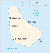
Barbados' total land area is 430 km² (166 sq mi), and it has a coastline of 97 km (60 mi) length. Sometimes compared to a pear
or leg of mutton for its physical shape. Along the north-south axis Barbados has a maximum length of 34 kilometres (21.1 mi), and east-west maximum breadth of 23 kilometres (14.3 mi).
The physical characteristics of Barbados are its lowlands or gently sloping, terraced plains, separated by rolling hills that generally parallel the coasts. Elevations in the interior range from 180 to 240 metres above sea level. Mount Hillaby is the highest point at 340 metres above sea level. Farther south, at Christ Church Ridge, elevations range from sixty to ninety metres. Eighty-five percent of the island's surface consists of coralline limestone twenty-four to thirty metres thick; Scotland District contains outcroppings of oceanic formations at the surface, however. Sugarcane is planted on almost 80 percent of the island's limestone surface. The soils vary in fertility; erosion is a problem, with crop loss resulting from landslides, washouts, and falling rocks. Most of the small streams are in Scotland District. The rest of the island has few surface streams; nevertheless, rainwater saturates the soil to produce underground channels such as the famous Coles Cave.
In 2009 and 2010, members of the upscale real estate industry in Barbados propose the creation of artificial island
s to be placed off the west coast. According to Paul Altman of Altman Realty the envisioned plan, would consist of two islands, one measuring 250 acres (1 km²) in size, and would house new tourism based developments and upscale boutique shops; while the second island would be 50 acres (202,343 m²) in size, and would serve as an open national park. Both proposed islands would be a short distance from the Deep Water Harbour in Bridgetown.
The south-eastern part of the island has undergone small scale oil and gas capturing from possibly as early as 1919 when the British Union Oil Company acquired over 75% of the drilling rights in Barbados. Similar to Trinidad and Tobago to the southwest, the territorial Atlantic Ocean surrounding Barbados has been found to contain fossil fuels, however ongoing research is being conducted to give estimates of actual quantities.
In 2006 a local Barbadian group has hinted that it may seek to form its own nation on Culpepper Island
. At present the group is not currently recognized by any nations. It is not known how this new nation could impact on the overall eastern EEZ of Barbados.http://www.pantribalconfederacy.com/confederacy/reclamation/
in the western Atlantic no longer observes Daylight Saving Time
, like many Caribbean nations. The last observance of the DST related time clock adjustment was between Sunday, 20 April 1980 at 2:00 AM – Thursday, 25 September 1980 at 2:00 AM. On 25 September of that year the clock was shifted from -3:00 –> -4:00 where it has remained since.
Geographic coordinates:
Map references:
Coastline:
Maritime claims:
Elevation extremes:
Irrigated land:
Total renewable water sources:
Freshwater withdrawal (domestic/industrial/agricultural)
Environment - international agreements:
Geography - note:
Atlantic Ocean
The Atlantic Ocean is the second-largest of the world's oceanic divisions. With a total area of about , it covers approximately 20% of the Earth's surface and about 26% of its water surface area...
; and is located at 13°10' north of the equator
Equator
An equator is the intersection of a sphere's surface with the plane perpendicular to the sphere's axis of rotation and containing the sphere's center of mass....
, and 59°32' west of the Prime Meridian
Prime Meridian
The Prime Meridian is the meridian at which the longitude is defined to be 0°.The Prime Meridian and its opposite the 180th meridian , which the International Date Line generally follows, form a great circle that divides the Earth into the Eastern and Western Hemispheres.An international...
. As the easternmost isle of the Lesser Antilles
Lesser Antilles
The Lesser Antilles are a long, partly volcanic island arc in the Western Hemisphere. Most of its islands form the eastern boundary of the Caribbean Sea with the Atlantic Ocean, with the remainder located in the southern Caribbean just north of South America...
in the West Indies, Barbados lies 100 kilometres (62 mi) east of the Windward Islands
Windward Islands
The Windward Islands are the southern islands of the Lesser Antilles, within the West Indies.-Name and geography:The Windward Islands are called such because they were more windward to sailing ships arriving in the New World than the Leeward Islands, given that the prevailing trade winds in the...
and Caribbean Sea
Caribbean Sea
The Caribbean Sea is a sea of the Atlantic Ocean located in the tropics of the Western hemisphere. It is bounded by Mexico and Central America to the west and southwest, to the north by the Greater Antilles, and to the east by the Lesser Antilles....
. The maritime claim for Barbados is a territorial sea of 12 nmi (22.2 km; 13.8 mi), with an exclusive economic zone
Exclusive Economic Zone
Under the law of the sea, an exclusive economic zone is a seazone over which a state has special rights over the exploration and use of marine resources, including production of energy from water and wind. It stretches from the seaward edge of the state's territorial sea out to 200 nautical...
of 200 nmi (370.4 km; 230.2 mi), this gives Barbados a total maritime area of 183,436 km2. Of the total EEZ area 70,000 km2, is already set aside for offshore oil exploration. A pending application to UNCLOS has placed for consideration a continental shelf
Continental shelf
The continental shelf is the extended perimeter of each continent and associated coastal plain. Much of the shelf was exposed during glacial periods, but is now submerged under relatively shallow seas and gulfs, and was similarly submerged during other interglacial periods. The continental margin,...
200 nmi (370.4 km; 230.2 mi) to the east and south (or to the edge of the continental margin). To the west, however, most of Barbados' maritime consist of a median lines with neighbours. These neighbours include: Martinique
Martinique
Martinique is an island in the eastern Caribbean Sea, with a land area of . Like Guadeloupe, it is an overseas region of France, consisting of a single overseas department. To the northwest lies Dominica, to the south St Lucia, and to the southeast Barbados...
, and Saint Lucia
Saint Lucia
Saint Lucia is an island country in the eastern Caribbean Sea on the boundary with the Atlantic Ocean. Part of the Lesser Antilles, it is located north/northeast of the island of Saint Vincent, northwest of Barbados and south of Martinique. It covers a land area of 620 km2 and has an...
to the northwest, Saint Vincent and the Grenadines
Saint Vincent and the Grenadines
Saint Vincent and the Grenadines is an island country in the Lesser Antilles chain, namely in the southern portion of the Windward Islands, which lie at the southern end of the eastern border of the Caribbean Sea where the latter meets the Atlantic Ocean....
to the west, Trinidad and Tobago
Trinidad and Tobago
Trinidad and Tobago officially the Republic of Trinidad and Tobago is an archipelagic state in the southern Caribbean, lying just off the coast of northeastern Venezuela and south of Grenada in the Lesser Antilles...
and Venezuela
Venezuela
Venezuela , officially called the Bolivarian Republic of Venezuela , is a tropical country on the northern coast of South America. It borders Colombia to the west, Guyana to the east, and Brazil to the south...
to the southwest, and Guyana
Guyana
Guyana , officially the Co-operative Republic of Guyana, previously the colony of British Guiana, is a sovereign state on the northern coast of South America that is culturally part of the Anglophone Caribbean. Guyana was a former colony of the Dutch and of the British...
to the southeast.
Barbados' total land area is 430 km² (166 sq mi), and it has a coastline of 97 km (60 mi) length. Sometimes compared to a pear
Pear
The pear is any of several tree species of genus Pyrus and also the name of the pomaceous fruit of these trees. Several species of pear are valued by humans for their edible fruit, but the fruit of other species is small, hard, and astringent....
or leg of mutton for its physical shape. Along the north-south axis Barbados has a maximum length of 34 kilometres (21.1 mi), and east-west maximum breadth of 23 kilometres (14.3 mi).
The physical characteristics of Barbados are its lowlands or gently sloping, terraced plains, separated by rolling hills that generally parallel the coasts. Elevations in the interior range from 180 to 240 metres above sea level. Mount Hillaby is the highest point at 340 metres above sea level. Farther south, at Christ Church Ridge, elevations range from sixty to ninety metres. Eighty-five percent of the island's surface consists of coralline limestone twenty-four to thirty metres thick; Scotland District contains outcroppings of oceanic formations at the surface, however. Sugarcane is planted on almost 80 percent of the island's limestone surface. The soils vary in fertility; erosion is a problem, with crop loss resulting from landslides, washouts, and falling rocks. Most of the small streams are in Scotland District. The rest of the island has few surface streams; nevertheless, rainwater saturates the soil to produce underground channels such as the famous Coles Cave.
In 2009 and 2010, members of the upscale real estate industry in Barbados propose the creation of artificial island
Artificial island
An artificial island or man-made island is an island or archipelago that has been constructed by people rather than formed by natural means...
s to be placed off the west coast. According to Paul Altman of Altman Realty the envisioned plan, would consist of two islands, one measuring 250 acres (1 km²) in size, and would house new tourism based developments and upscale boutique shops; while the second island would be 50 acres (202,343 m²) in size, and would serve as an open national park. Both proposed islands would be a short distance from the Deep Water Harbour in Bridgetown.
The south-eastern part of the island has undergone small scale oil and gas capturing from possibly as early as 1919 when the British Union Oil Company acquired over 75% of the drilling rights in Barbados. Similar to Trinidad and Tobago to the southwest, the territorial Atlantic Ocean surrounding Barbados has been found to contain fossil fuels, however ongoing research is being conducted to give estimates of actual quantities.
In 2006 a local Barbadian group has hinted that it may seek to form its own nation on Culpepper Island
Culpepper Island
Culpeper Island is a tiny rock in the Atlantic Ocean close to Bayfield and Ragged Point in Saint Philip, Barbados.The island is uninhabited and according to some accounts the island is now overgrown with bush and some coconut trees....
. At present the group is not currently recognized by any nations. It is not known how this new nation could impact on the overall eastern EEZ of Barbados.http://www.pantribalconfederacy.com/confederacy/reclamation/
DST
BarbadosBarbados
Barbados is an island country in the Lesser Antilles. It is in length and as much as in width, amounting to . It is situated in the western area of the North Atlantic and 100 kilometres east of the Windward Islands and the Caribbean Sea; therein, it is about east of the islands of Saint...
in the western Atlantic no longer observes Daylight Saving Time
Daylight saving time
Daylight saving time —also summer time in several countries including in British English and European official terminology —is the practice of temporarily advancing clocks during the summertime so that afternoons have more daylight and mornings have less...
, like many Caribbean nations. The last observance of the DST related time clock adjustment was between Sunday, 20 April 1980 at 2:00 AM – Thursday, 25 September 1980 at 2:00 AM. On 25 September of that year the clock was shifted from -3:00 –> -4:00 where it has remained since.
Location
- BarbadosBarbadosBarbados is an island country in the Lesser Antilles. It is in length and as much as in width, amounting to . It is situated in the western area of the North Atlantic and 100 kilometres east of the Windward Islands and the Caribbean Sea; therein, it is about east of the islands of Saint...
is Caribbean: an island between the Caribbean SeaCaribbean SeaThe Caribbean Sea is a sea of the Atlantic Ocean located in the tropics of the Western hemisphere. It is bounded by Mexico and Central America to the west and southwest, to the north by the Greater Antilles, and to the east by the Lesser Antilles....
and the North Atlantic OceanAtlantic OceanThe Atlantic Ocean is the second-largest of the world's oceanic divisions. With a total area of about , it covers approximately 20% of the Earth's surface and about 26% of its water surface area...
, northeast of VenezuelaVenezuelaVenezuela , officially called the Bolivarian Republic of Venezuela , is a tropical country on the northern coast of South America. It borders Colombia to the west, Guyana to the east, and Brazil to the south...
Geographic coordinates:
- 13°10′N 59°32′W
Map references:
- Central AmericaCentral AmericaCentral America is the central geographic region of the Americas. It is the southernmost, isthmian portion of the North American continent, which connects with South America on the southeast. When considered part of the unified continental model, it is considered a subcontinent...
and the Caribbean
Area comparative
- AustraliaAustraliaAustralia , officially the Commonwealth of Australia, is a country in the Southern Hemisphere comprising the mainland of the Australian continent, the island of Tasmania, and numerous smaller islands in the Indian and Pacific Oceans. It is the world's sixth-largest country by total area...
comparative: 5.5 times smaller than the Australian Capital TerritoryAustralian Capital TerritoryThe Australian Capital Territory, often abbreviated ACT, is the capital territory of the Commonwealth of Australia and is the smallest self-governing internal territory... - CanadaCanadaCanada is a North American country consisting of ten provinces and three territories. Located in the northern part of the continent, it extends from the Atlantic Ocean in the east to the Pacific Ocean in the west, and northward into the Arctic Ocean...
comparative: slightly larger than LondonLondon, OntarioLondon is a city in Southwestern Ontario, Canada, situated along the Quebec City – Windsor Corridor. The city has a population of 352,395, and the metropolitan area has a population of 457,720, according to the 2006 Canadian census; the metro population in 2009 was estimated at 489,274. The city...
in the Province of OntarioOntarioOntario is a province of Canada, located in east-central Canada. It is Canada's most populous province and second largest in total area. It is home to the nation's most populous city, Toronto, and the nation's capital, Ottawa.... - United KingdomUnited KingdomThe United Kingdom of Great Britain and Northern IrelandIn the United Kingdom and Dependencies, other languages have been officially recognised as legitimate autochthonous languages under the European Charter for Regional or Minority Languages...
comparative: slightly larger than the Isle of WightIsle of WightThe Isle of Wight is a county and the largest island of England, located in the English Channel, on average about 2–4 miles off the south coast of the county of Hampshire, separated from the mainland by a strait called the Solent...
or Saint HelenaSaint HelenaSaint Helena , named after St Helena of Constantinople, is an island of volcanic origin in the South Atlantic Ocean. It is part of the British overseas territory of Saint Helena, Ascension and Tristan da Cunha which also includes Ascension Island and the islands of Tristan da Cunha... - United StatesUnited StatesThe United States of America is a federal constitutional republic comprising fifty states and a federal district...
comparative: 2.5 times the size of Washington, DC, about the size of San Antonio, TexasSan Antonio, TexasSan Antonio is the seventh-largest city in the United States of America and the second-largest city within the state of Texas, with a population of 1.33 million. Located in the American Southwest and the south–central part of Texas, the city serves as the seat of Bexar County. In 2011,...
, or half the size of New York CityNew York CityNew York is the most populous city in the United States and the center of the New York Metropolitan Area, one of the most populous metropolitan areas in the world. New York exerts a significant impact upon global commerce, finance, media, art, fashion, research, technology, education, and...
Land boundaries
- 0 km
Coastline:
- 97 km
Maritime claims:
- Exclusive economic zone: 200 nmi (370.4 km; 230.2 mi)
- Territorial sea: 12 nmi (22.2 km; 13.8 mi)
Terrain
- Relatively flat; rises gently to central highland region
Elevation extremes:
- Lowest point: Atlantic OceanAtlantic OceanThe Atlantic Ocean is the second-largest of the world's oceanic divisions. With a total area of about , it covers approximately 20% of the Earth's surface and about 26% of its water surface area...
0 m - Highest point: Mount HillabyMount HillabyThe peak of Mount Hillaby is the highest point on the Eastern Caribbean island nation of Barbados. The peak is located in the parish of Saint Andrew. It immediately overlooks the area known as the Scotland District to the north and east which comprises geologically old sediments prone to...
336 m
Land use
- Arable land: 37.21%
- Permanent crops: 2.33%
- Other: 60.46% (2005)
Irrigated land:
- 50 km² (2003)
Total renewable water sources:
- 0.1 cu km (2003)
Freshwater withdrawal (domestic/industrial/agricultural)
- total: 0.09 cu km/yr (33%/44%/22%)
- per capita: 333 cu m/yr (2000)
Environment - current issues
- Pollution of coastal waters from waste disposal by ships; soil erosion; illegal solid waste disposal threatens contamination of aquifers
Environment - international agreements:
- Party to: Biodiversity, Climate Change, Climate Change-Kyoto Protocol, Desertification, Endangered Species, Hazardous Wastes, Law of the Sea, Marine Dumping, Ozone Layer Protection, Ship Pollution, Wetlands
- Signed, but not ratified: none of the selected agreements
Geography - note:
- Easternmost Caribbean island
Climate
Barbados lies within the tropics. Its generally pleasant maritime climate is influenced by northeast trade winds, which moderate the tropical temperature. Cool, northeasterly trade winds are prevalent during the December to June dry season. The overall annual temperature ranges from 24 to 28 °C (75.2 to 82.4 °F); slightly lower temperatures prevail at higher elevations. Humidity levels are between 71 percent and 76 percent year round. Rainfall occurs primarily between July and December and varies considerably with elevation. Rainfall may average 1875 millimetres (73.8 in) per year in the higher central area as compared with 1275 millimetres (50.2 in) in the coastal zone.External links
- GEOnet Names Server
- BajanNAV - Free satellite navigation software for Barbados