
Geography of Anguilla
Encyclopedia
This article describes the geography
of Anguilla
.
Anguilla is one of the Leeward Islands
, which lie between the Caribbean Sea in the west and the open Atlantic Ocean in the east. It is a long, flat, dry/wet, scrub-covered
coral island
, south and east of Puerto Rico
and north of the Windward
chain. It is an island of no significant elevations with its terrain consisting entirely of beaches, dunes, and low limestone bluffs.
, is 65 m (213 ft). Crocus Hill is among the cliffs that line the northern shore.
Geographic coordinates: 18 15 N, 63 10 W
Map references: Central America and the Caribbean
Area:
Area - comparative: about half the size of Washington DC
Land boundaries: 0 km
Coastline: 61 km
Maritime claims:
Climate: tropical moderated by northeast trade winds
Terrain: flat and low-lying island
of coral
and limestone
Elevation extremes:
Natural resources: salt
, fish
, lobster
Land use:
Irrigated land: NA
Natural hazards: frequent hurricanes and other tropical
storms (July to October)
Environment - current issues: supplies of potable water
sometimes cannot meet increasing demand largely because of poor distribution system.
. The city has a rather dry climate, moderated by northeast trade wind
s. Temperatures vary little throughout the year. Average daily maxima range from about 27 °C (80.6 °F) in December to 30 °C (86 °F) in July. Rainfall is erratic, averaging about 900 mm (35.4 in) per year, the wettest months being September and October, and the driest February and March. Anguilla is vulnerable to hurricanes from June to November, peak season August to mid-October.
The island suffered damage in 1995 from Hurricane Luis
.
s, woodland
, pasture
s, crops, or arable land
s. Its dry climate and thin soil hamper commercial agricultural development.
Geography
Geography is the science that studies the lands, features, inhabitants, and phenomena of Earth. A literal translation would be "to describe or write about the Earth". The first person to use the word "geography" was Eratosthenes...
of Anguilla
Anguilla
Anguilla is a British overseas territory and overseas territory of the European Union in the Caribbean. It is one of the most northerly of the Leeward Islands in the Lesser Antilles, lying east of Puerto Rico and the Virgin Islands and directly north of Saint Martin...
.
 |
|
| Continent Continent A continent is one of several very large landmasses on Earth. They are generally identified by convention rather than any strict criteria, with seven regions commonly regarded as continents—they are : Asia, Africa, North America, South America, Antarctica, Europe, and Australia.Plate tectonics is... |
North America North America North America is a continent wholly within the Northern Hemisphere and almost wholly within the Western Hemisphere. It is also considered a northern subcontinent of the Americas... |
| Subregion Subregion A subregion is a conceptual unit which derives from a larger region or continent and is usually based on location. Cardinal directions, such as south or southern, are commonly used to define a subregion.- United Nations subregions :... |
Caribbean Caribbean The Caribbean is a crescent-shaped group of islands more than 2,000 miles long separating the Gulf of Mexico and the Caribbean Sea, to the west and south, from the Atlantic Ocean, to the east and north... |
| Geographic coordinates | 18°15′N 63°10′W |
| Area Area Area is a quantity that expresses the extent of a two-dimensional surface or shape in the plane. Area can be understood as the amount of material with a given thickness that would be necessary to fashion a model of the shape, or the amount of paint necessary to cover the surface with a single coat... - Total - Water |
Ranked 220th 102 km² 1 E12 m² To help compare orders of magnitude of different surface areas, here is a list of areas between 1 million km2 and 10 million km2. See also areas of other orders of magnitude.* Areas smaller than 1 million km2* 1,000,000 km2 is equal to:** 1 E+12 m²... 0 km |
| Coastline | 61 km |
| Land boundaries | 0 km |
| Countries bordered | none |
| Highest point | Crocus Hill Crocus Hill Crocus Hill is the highest point of Anguilla, a British overseas territory in the Caribbean, with an altitude of .-External links: , Maplandia.com.... , 65 m |
| Lowest point | Caribbean Sea Caribbean Sea The Caribbean Sea is a sea of the Atlantic Ocean located in the tropics of the Western hemisphere. It is bounded by Mexico and Central America to the west and southwest, to the north by the Greater Antilles, and to the east by the Lesser Antilles.... , 0 m |
| Longest river | none |
| Largest inland body of water | |
| Land Use - Arable land - Permanent crops - Other |
0 % 0 % 100 % (2005 est.) |
| Irrigated Land: N/A | |
| Climate Climate Climate encompasses the statistics of temperature, humidity, atmospheric pressure, wind, rainfall, atmospheric particle count and other meteorological elemental measurements in a given region over long periods... : |
tropical |
| Terrain Terrain Terrain, or land relief, is the vertical and horizontal dimension of land surface. When relief is described underwater, the term bathymetry is used... : |
flat and low-lying island Island An island or isle is any piece of sub-continental land that is surrounded by water. Very small islands such as emergent land features on atolls can be called islets, cays or keys. An island in a river or lake may be called an eyot , or holm... of coral Coral Corals are marine animals in class Anthozoa of phylum Cnidaria typically living in compact colonies of many identical individual "polyps". The group includes the important reef builders that inhabit tropical oceans and secrete calcium carbonate to form a hard skeleton.A coral "head" is a colony of... and limestone Limestone Limestone is a sedimentary rock composed largely of the minerals calcite and aragonite, which are different crystal forms of calcium carbonate . Many limestones are composed from skeletal fragments of marine organisms such as coral or foraminifera.... |
| Natural resources | salt Salt In chemistry, salts are ionic compounds that result from the neutralization reaction of an acid and a base. They are composed of cations and anions so that the product is electrically neutral... , fish Fish Fish are a paraphyletic group of organisms that consist of all gill-bearing aquatic vertebrate animals that lack limbs with digits. Included in this definition are the living hagfish, lampreys, and cartilaginous and bony fish, as well as various extinct related groups... , lobster Lobster Clawed lobsters comprise a family of large marine crustaceans. Highly prized as seafood, lobsters are economically important, and are often one of the most profitable commodities in coastal areas they populate.Though several groups of crustaceans are known as lobsters, the clawed lobsters are most... |
| Natural hazards | hurricanes, tropical storms (July to October) |
| Environmental issues | low water Water Water is a chemical substance with the chemical formula H2O. A water molecule contains one oxygen and two hydrogen atoms connected by covalent bonds. Water is a liquid at ambient conditions, but it often co-exists on Earth with its solid state, ice, and gaseous state . Water also exists in a... supplies |
Anguilla is one of the Leeward Islands
Leeward Islands
The Leeward Islands are a group of islands in the West Indies. They are the northern islands of the Lesser Antilles chain. As a group they start east of Puerto Rico and reach southward to Dominica. They are situated where the northeastern Caribbean Sea meets the western Atlantic Ocean...
, which lie between the Caribbean Sea in the west and the open Atlantic Ocean in the east. It is a long, flat, dry/wet, scrub-covered
coral island
Coral island
A coral island is the result of an atoll whose lagoon has dried up or been filled in with coral sand and detritus. This state is typically the last in the life cycle of an island, the first being volcanic and the second being an atoll. Most of the world's coral islands are in the Pacific Ocean...
, south and east of Puerto Rico
Puerto Rico
Puerto Rico , officially the Commonwealth of Puerto Rico , is an unincorporated territory of the United States, located in the northeastern Caribbean, east of the Dominican Republic and west of both the United States Virgin Islands and the British Virgin Islands.Puerto Rico comprises an...
and north of the Windward
Windward Islands
The Windward Islands are the southern islands of the Lesser Antilles, within the West Indies.-Name and geography:The Windward Islands are called such because they were more windward to sailing ships arriving in the New World than the Leeward Islands, given that the prevailing trade winds in the...
chain. It is an island of no significant elevations with its terrain consisting entirely of beaches, dunes, and low limestone bluffs.
Hills
Anguilla’s highest elevation, Crocus HillCrocus Hill
Crocus Hill is the highest point of Anguilla, a British overseas territory in the Caribbean, with an altitude of .-External links: , Maplandia.com....
, is 65 m (213 ft). Crocus Hill is among the cliffs that line the northern shore.
Coastline
The numerous bays — Barnes, Little, Rendezvous, Shoal, and Road—lure many vacationers to this tropical island. The coast and the beautiful, pristine beaches are integral to the tourism-based economy of Anguilla. Because of Anguilla’s warm climate, the beaches can be used year-round.Statistics
Location: Caribbean, island in the Caribbean Sea, east of Puerto RicoPuerto Rico
Puerto Rico , officially the Commonwealth of Puerto Rico , is an unincorporated territory of the United States, located in the northeastern Caribbean, east of the Dominican Republic and west of both the United States Virgin Islands and the British Virgin Islands.Puerto Rico comprises an...
Geographic coordinates: 18 15 N, 63 10 W
Map references: Central America and the Caribbean
Caribbean
The Caribbean is a crescent-shaped group of islands more than 2,000 miles long separating the Gulf of Mexico and the Caribbean Sea, to the west and south, from the Atlantic Ocean, to the east and north...
Area:
- total: 91 km² (35 sq mi)
- land: 91 km² (35 sq mi)
- water: 0 km² (0 sq mi)
Area - comparative: about half the size of Washington DC
Land boundaries: 0 km
Coastline: 61 km
Maritime claims:
- exclusive fishing zone: 200 nmi (370.4 km; 230.2 mi)
- territorial sea: 3 nmi (5.6 km; 3.5 mi)
Climate: tropical moderated by northeast trade winds
Terrain: flat and low-lying island
Island
An island or isle is any piece of sub-continental land that is surrounded by water. Very small islands such as emergent land features on atolls can be called islets, cays or keys. An island in a river or lake may be called an eyot , or holm...
of coral
Coral
Corals are marine animals in class Anthozoa of phylum Cnidaria typically living in compact colonies of many identical individual "polyps". The group includes the important reef builders that inhabit tropical oceans and secrete calcium carbonate to form a hard skeleton.A coral "head" is a colony of...
and limestone
Limestone
Limestone is a sedimentary rock composed largely of the minerals calcite and aragonite, which are different crystal forms of calcium carbonate . Many limestones are composed from skeletal fragments of marine organisms such as coral or foraminifera....
Elevation extremes:
- lowest point: Caribbean Sea 0 m
- highest point: Crocus Hill 65 m
Natural resources: salt
Salt
In chemistry, salts are ionic compounds that result from the neutralization reaction of an acid and a base. They are composed of cations and anions so that the product is electrically neutral...
, fish
Fish
Fish are a paraphyletic group of organisms that consist of all gill-bearing aquatic vertebrate animals that lack limbs with digits. Included in this definition are the living hagfish, lampreys, and cartilaginous and bony fish, as well as various extinct related groups...
, lobster
Lobster
Clawed lobsters comprise a family of large marine crustaceans. Highly prized as seafood, lobsters are economically important, and are often one of the most profitable commodities in coastal areas they populate.Though several groups of crustaceans are known as lobsters, the clawed lobsters are most...
Land use:
- arable land: 0%
- permanent crops: 0%
- permanent pastures: 0%
- forests and woodland: 0%
- other: 100% (mostly rock with sparse scrub oak,trees, some commercial salt ponds)
Irrigated land: NA
Natural hazards: frequent hurricanes and other tropical
storms (July to October)
Environment - current issues: supplies of potable water
sometimes cannot meet increasing demand largely because of poor distribution system.
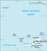
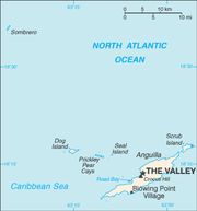
Islands and cays
The territory of Anguilla consists of the island of Anguilla itself (by far the largest), as well as numerous other islands and cays, most of which are very small and uninhabited. These include:- AnguillitaAnguillitaAnguillita is a small, uninhabited rocky island off the western tip of, and part of the country of Anguilla, located in the Caribbean. It's the dependency's southernmost point, located at coordinates 18°9' N, 63°11' W...
- Blowing Rock
- Cove Cay
- Crocus Cay
- Deadman's Cay
- Dog IslandDog Island, AnguillaDog Island is an uninhabited small island of 511 acres in size located approximately 13km to the northwest of Anguilla.-References:...
- East Cay
- Little Island
- Little Scrub Island
- Mid Cay
- North Cay
- Prickly Pear CaysPrickly Pear CaysThe Prickly Pear Cays, sometimes spelled Prickley Pear Cays, are a small pair of uninhabited islands about six miles from Road Bay, Anguilla, in the Leeward Islands of the Caribbean. They are divided by a narrow boat channel between Prickly Pear East and Prickly Pear West...
- Rabbit Island
- Sandy Island, also known as Sand Island
- Scilly Cay
- Scrub Island
- Seal IslandSeal Island, AnguillaSeal Island is a small island off the northwest coast of Anguilla. It is located some two kilometres to the west of the Prickly Pear Cays at 18° 16' N, 63° 9' W , and lies at the centre of the Seal island Reef System Marine Park. The area is popular with scuba divers....
- SombreroSombrero, AnguillaSombrero, also known as Hat Island, is the northernmost island of the Lesser Antilles in position 18° 60'N, 63° 40'W. It lies north west of Anguilla across the Dog and Prickly Pear Passage. The distance to Dog Island, the closest island of Anguilla, is . Sombrero is long north-south, and wide....
, also known as Hat Island - South Cay
- South Wager Island
- West Cay
Districts
Anguilla is divided into fourteen districts:- Blowing Point
- East EndEast End, AnguillaEast End is one of the fourteen Districts of Anguilla. Its population as of the 2001 census was 614.-Reference:...
- George HillGeorge Hill, AnguillaGeorge Hill is one of the fourteen Districts of Anguilla. Its population as of the 2001 census was 791.-Reference:...
- Island HarbourIsland Harbour, AnguillaIsland Harbour is one of the fourteen Districts of Anguilla. Its population as of the 2001 census was 855.- Politics :The incumbent is Othlyn Vanterpool of the Anguilla United Front.-Reference:...
- North HillNorth Hill, AnguillaNorth Hill is one of the fourteen Districts of Anguilla. Its population as of the 2001 census was 439.-Reference:...
- North SideNorth Side, AnguillaNorth Side is one of the fourteen Districts of Anguilla. Its population as of the 2001 census was 1,195.-Reference:...
- Sandy GroundSandy Ground, AnguillaThe village of Sandy Ground is Anguilla's main port/harbour. The long curved beach is backed by high cliffs and a salt pond. According to the 2001 census Sandy Ground has a population of 274....
- Sandy HillSandy Hill, AnguillaSandy Hill is one of the fourteen Districts of Anguilla. Its population as of the 2001 census was 557.- Politics :The incumbent is Jerome Roberts of the Anguilla Progressive Party.-Reference:...
- South HillSouth Hill, AnguillaSouth Hill is one of the fourteen Districts of Anguilla. Its population as of the 2001 census was 1,495.-Reference:...
- Stoney GroundStoney GroundStoney Ground is one of the fourteen Districts of Anguilla. Its population as of the 2001 census was 1,133.-Reference:...
- The FarringtonThe FarringtonThe Farrington is one of the fourteen Districts of Anguilla. Its population as of the 2001 census was 546.-Reference:...
- The QuarterThe Quarter, AnguillaThe Quarter is one of the fourteen Districts of Anguilla. Its population as of the 2001 census was 978.-Reference:...
- The ValleyThe Valley, Anguilla-Population:-References:...
- West EndWest End, AnguillaWest End is one of the fourteen Districts of Anguilla. Its population as of the 2001 census was 736.-Reference:...
Climate
Anguilla features a tropical wet and dry climate under the Koppen climate classificationKöppen climate classification
The Köppen climate classification is one of the most widely used climate classification systems. It was first published by Crimea German climatologist Wladimir Köppen in 1884, with several later modifications by Köppen himself, notably in 1918 and 1936...
. The city has a rather dry climate, moderated by northeast trade wind
Trade wind
The trade winds are the prevailing pattern of easterly surface winds found in the tropics, within the lower portion of the Earth's atmosphere, in the lower section of the troposphere near the Earth's equator...
s. Temperatures vary little throughout the year. Average daily maxima range from about 27 °C (80.6 °F) in December to 30 °C (86 °F) in July. Rainfall is erratic, averaging about 900 mm (35.4 in) per year, the wettest months being September and October, and the driest February and March. Anguilla is vulnerable to hurricanes from June to November, peak season August to mid-October.
The island suffered damage in 1995 from Hurricane Luis
Hurricane Luis
Hurricane Luis was one of the deadliest and most destructive hurricanes of the 1995 Atlantic hurricane season, with maximum sustained winds of 140 mph . The storm was the twelfth tropical storm, sixth hurricane, and second major hurricane of the season...
.
Vegetation
Anguilla’s coral and limestone terrain provide no subsistence possibilities for forestForest
A forest, also referred to as a wood or the woods, is an area with a high density of trees. As with cities, depending where you are in the world, what is considered a forest may vary significantly in size and have various classification according to how and what of the forest is composed...
s, woodland
Woodland
Ecologically, a woodland is a low-density forest forming open habitats with plenty of sunlight and limited shade. Woodlands may support an understory of shrubs and herbaceous plants including grasses. Woodland may form a transition to shrubland under drier conditions or during early stages of...
, pasture
Pasture
Pasture is land used for grazing. Pasture lands in the narrow sense are enclosed tracts of farmland, grazed by domesticated livestock, such as horses, cattle, sheep or swine. The vegetation of tended pasture, forage, consists mainly of grasses, with an interspersion of legumes and other forbs...
s, crops, or arable land
Arable land
In geography and agriculture, arable land is land that can be used for growing crops. It includes all land under temporary crops , temporary meadows for mowing or pasture, land under market and kitchen gardens and land temporarily fallow...
s. Its dry climate and thin soil hamper commercial agricultural development.
External links
- Caribbean-On-Line.com provides detailed maps of Anguilla.
- Districts of Anguilla, Statoids.com
- Anguilla 2001 Census, Government of Anguilla