
Frontenac State Park
Encyclopedia
Frontenac State Park is a state park
of Minnesota
, USA, on the Mississippi River
10 miles (16 km) southeast of Red Wing
. The park is notable both for its history and for its birdwatching
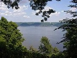
opportunities. The centerpiece of the park is a 430 feet (131.1 m), 3 miles (4.8 km) steep limestone bluff overlooking Lake Pepin
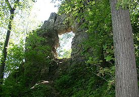
, a natural widening of the Mississippi. The bluff is variously called Garrard's Bluff or Point No-Point, the latter name coming from riverboat captains because of the optical illusion that it protruded into the Mississippi River. There is a natural limestone arch
on the blufftop called In-Yan-Teopa, a Dakota name meaning "Rock With Opening". Park lands entirely surround the town of Frontenac
, once a high-class resort at the end of the 19th century.
 The limestone
was laid down 500 million years ago as organic sediments settled to the bottom of a shallow sea that covered much of the Midwest
. Much later Glacial River Warren
carried torrents of runoff from the melting glaciers of the last ice age
. Flowing out of Lake Agassiz
, Glacial River Warren carved the Minnesota River
valley and the Mississippi River Valley, leaving steep bluffs along the latter's banks. At times Glacial River Warren overflowed its bed and Garrard's Bluff would have been an island. The area is near the northern extreme of the Driftless Area of Minnesota, a region that remained unglaciated during the phases of the last ice age
.
In the present day, a creek flows through the eastern end of the park into Lake Pepin. Wells Creek carries substantial amounts of sand eroded out of the nearby hills. As it hits the slow-moving river water, it drops its sediment load, creating a delta
and Sand Point, a sand spit
jutting perpendicularly out into the lake. Downstream the Chippewa River
performs the same action on a larger scale. This sediment blockage is what causes the Mississippi to widen into Lake Pepin.
, basswood, elm
, oak
, and aspen
. The back of the bluff transitions from this forest to lightly wooden meadows to prairie
. The eastern end of the park is a bottomland forest of cottonwood, maple, and willow
.
, the Frontenac area has been known for birdwatching since 1900. 260 bird species have been sighted in Frontenac State Park. Bald eagle
s and golden eagle
s are seen around the bluff. The bottomland forest is excellent habitat for warblers
. Sand Point is a popular rest-stop for migrants, including ruddy turnstones
and sanderling
s. One terrestrial species of note is the timber rattlesnake
, though it is rare in the park and only dangerous if provoked.
were living and dying within the park between 400 BCE and 300 CE. At the beginning of historical times Dakota
and Fox people lived in the region. The first Europeans to see this area were Father Louis Hennepin
and his exploration party in 1680. In 1727 a party from Montreal
led by René Boucher came ashore and built a fort. Fort Beauharnois
was intended as a base of operations for trade with the Dakota and for French explorers seeking a route to the Pacific. Ultimately a number of French posts were built on either shore of Lake Pepin until the territory was ceded to Britain after the French and Indian War
. Only one of those forts has been located by archaeologists.
The first American settler was James "Bully" Wells, who had a fur trading post near modern Frontenac town by 1840. Later he sold his interests to a Dutch immigrant named Evert Westervelt. However the Dakota were evicted onto reservations, and Westervelt was forced to diversify. He partnered with another settler, Israel Garrard, and established a town in 1857 which he named after himself. Two years later Garrard bought out Westervelt and renamed the town Frontenac, after Louis de Buade de Frontenac
who had been governor of New France
in the late 17th century. Garrard served in the Civil War
, rising to the rank of general. After the war he helped turn Frontenac into a summer resort for the leisure class. His brother Jeptha Garrard was an inventor of flying machines, which were tested, unsuccessfully, from the bluff overlooking the town. Wealthy visitors arrived in Frontenac by steamboat
from as far away as New Orleans
. Meanwhile limestone was quarried from the bluff. The Cathedral of Saint John the Divine
in New York City
was constructed of stone from Frontenac. Frontenac's heyday ended when railroads supplanted river travel at the end of the 1800s.
Proposals were made in the 1920s and 30s to protect Garrard's Bluff, Wells Creek, and Sand Point. However serious efforts didn't get underway until a local advocacy group purchased 160 acres (64.7 ha) in 1955. Their holdings more than doubled the next year when 200 acres (80.9 ha) of Garrard's Bluff were donated by the chairman of an insurance company. The group lobbied directly to state legislators and other influential people. However other residents of Frontenac were fiercely opposed to a park, fearing that heightened visitation would compromise the town's charm and disturb the wildlife. These concerns were not without merit; at one point there were plans for a "skyline drive" along the blufftop. A bill authorizing the park passed in 1957, with sharp restrictions on recreational development. Purchasing the land from its current owners was similarly contentious. The owner of Sand Point was a particularly adamant holdout, and several tracts had to be acquired through eminent domain
. Modest recreational facilities were not installed until the mid-1960s. Land has been added to the park over the years but the minimal-development ethic has been maintained.
State park
State parks are parks or other protected areas managed at the federated state level within those nations which use "state" as a political subdivision. State parks are typically established by a state to preserve a location on account of its natural beauty, historic interest, or recreational...
of Minnesota
Minnesota
Minnesota is a U.S. state located in the Midwestern United States. The twelfth largest state of the U.S., it is the twenty-first most populous, with 5.3 million residents. Minnesota was carved out of the eastern half of the Minnesota Territory and admitted to the Union as the thirty-second state...
, USA, on the Mississippi River
Mississippi River
The Mississippi River is the largest river system in North America. Flowing entirely in the United States, this river rises in western Minnesota and meanders slowly southwards for to the Mississippi River Delta at the Gulf of Mexico. With its many tributaries, the Mississippi's watershed drains...
10 miles (16 km) southeast of Red Wing
Red Wing, Minnesota
Red Wing is a city in Goodhue County, Minnesota, United States, on the Mississippi River. The population was 16,459 at the 2010 census. It is the county seat of Goodhue County....
. The park is notable both for its history and for its birdwatching
Birdwatching
Birdwatching or birding is the observation of birds as a recreational activity. It can be done with the naked eye, through a visual enhancement device like binoculars and telescopes, or by listening for bird sounds. Birding often involves a significant auditory component, as many bird species are...
opportunities. The centerpiece of the park is a 430 feet (131.1 m), 3 miles (4.8 km) steep limestone bluff overlooking Lake Pepin
Lake Pepin
Lake Pepin is a naturally occurring lake, and the widest naturally occurring part of the Mississippi River, located approximately 60 miles downstream from Saint Paul, Minnesota. It is a widening of the river on the border between Minnesota and Wisconsin. The formation of the lake was caused by the...
, a natural widening of the Mississippi. The bluff is variously called Garrard's Bluff or Point No-Point, the latter name coming from riverboat captains because of the optical illusion that it protruded into the Mississippi River. There is a natural limestone arch
Natural arch
A natural arch or natural bridge is a natural geological formation where a rock arch forms, with an opening underneath. Most natural arches form as a narrow ridge, walled by cliffs, become narrower from erosion, with a softer rock stratum under the cliff-forming stratum gradually eroding out until...
on the blufftop called In-Yan-Teopa, a Dakota name meaning "Rock With Opening". Park lands entirely surround the town of Frontenac
Frontenac, Minnesota
Frontenac is an unincorporated community in Florence Township, Goodhue County, Minnesota, United States, on the Mississippi River.-History:James Wells established a trading post in the location that would become Frontenac before 1850. He dealt mostly with Native Americans until the railroad was...
, once a high-class resort at the end of the 19th century.
Geology
Limestone
Limestone is a sedimentary rock composed largely of the minerals calcite and aragonite, which are different crystal forms of calcium carbonate . Many limestones are composed from skeletal fragments of marine organisms such as coral or foraminifera....
was laid down 500 million years ago as organic sediments settled to the bottom of a shallow sea that covered much of the Midwest
Midwestern United States
The Midwestern United States is one of the four U.S. geographic regions defined by the United States Census Bureau, providing an official definition of the American Midwest....
. Much later Glacial River Warren
Glacial River Warren
right|thumb|210px|The course of the Minnesota River follows the valley carved by Glacial River WarrenGlacial River Warren or River Warren was a prehistoric river that drained Lake Agassiz in central North America between 11,700 and 9,400 years ago...
carried torrents of runoff from the melting glaciers of the last ice age
Wisconsin glaciation
The last glacial period was the most recent glacial period within the current ice age occurring during the last years of the Pleistocene, from approximately 110,000 to 10,000 years ago....
. Flowing out of Lake Agassiz
Lake Agassiz
Lake Agassiz was an immense glacial lake located in the center of North America. Fed by glacial runoff at the end of the last glacial period, its area was larger than all of the modern Great Lakes combined, and it held more water than contained by all lakes in the world today.-Conception:First...
, Glacial River Warren carved the Minnesota River
Minnesota River
The Minnesota River is a tributary of the Mississippi River, approximately 332 miles long, in the U.S. state of Minnesota. It drains a watershed of nearly , in Minnesota and about in South Dakota and Iowa....
valley and the Mississippi River Valley, leaving steep bluffs along the latter's banks. At times Glacial River Warren overflowed its bed and Garrard's Bluff would have been an island. The area is near the northern extreme of the Driftless Area of Minnesota, a region that remained unglaciated during the phases of the last ice age
Wisconsin glaciation
The last glacial period was the most recent glacial period within the current ice age occurring during the last years of the Pleistocene, from approximately 110,000 to 10,000 years ago....
.
In the present day, a creek flows through the eastern end of the park into Lake Pepin. Wells Creek carries substantial amounts of sand eroded out of the nearby hills. As it hits the slow-moving river water, it drops its sediment load, creating a delta
River delta
A delta is a landform that is formed at the mouth of a river where that river flows into an ocean, sea, estuary, lake, reservoir, flat arid area, or another river. Deltas are formed from the deposition of the sediment carried by the river as the flow leaves the mouth of the river...
and Sand Point, a sand spit
Spit (landform)
A spit or sandspit is a deposition landform found off coasts. At one end, spits connect to land, and extend into the sea. A spit is a type of bar or beach that develops where a re-entrant occurs, such as at cove's headlands, by the process of longshore drift...
jutting perpendicularly out into the lake. Downstream the Chippewa River
Chippewa River (Wisconsin)
The Chippewa River in Wisconsin flows approximately 183 miles through west-central and northwestern Wisconsin. It was once navigable for approximately 50 miles of its length, from the Mississippi River, by Durand, northeast to Eau Claire. Its catchment defines a portion of the northern boundary...
performs the same action on a larger scale. This sediment blockage is what causes the Mississippi to widen into Lake Pepin.
Flora
The forest on the bluff is a mix of mapleMaple
Acer is a genus of trees or shrubs commonly known as maple.Maples are variously classified in a family of their own, the Aceraceae, or together with the Hippocastanaceae included in the family Sapindaceae. Modern classifications, including the Angiosperm Phylogeny Group system, favour inclusion in...
, basswood, elm
Elm
Elms are deciduous and semi-deciduous trees comprising the genus Ulmus in the plant family Ulmaceae. The dozens of species are found in temperate and tropical-montane regions of North America and Eurasia, ranging southward into Indonesia. Elms are components of many kinds of natural forests...
, oak
Oak
An oak is a tree or shrub in the genus Quercus , of which about 600 species exist. "Oak" may also appear in the names of species in related genera, notably Lithocarpus...
, and aspen
Aspen
Populus section Populus, of the Populus genus, includes the aspen trees and the white poplar Populus alba. The five typical aspens are all native to cold regions with cool summers, in the north of the Northern Hemisphere, extending south at high altitudes in the mountains. The White Poplar, by...
. The back of the bluff transitions from this forest to lightly wooden meadows to prairie
Prairie
Prairies are considered part of the temperate grasslands, savannas, and shrublands biome by ecologists, based on similar temperate climates, moderate rainfall, and grasses, herbs, and shrubs, rather than trees, as the dominant vegetation type...
. The eastern end of the park is a bottomland forest of cottonwood, maple, and willow
Willow
Willows, sallows, and osiers form the genus Salix, around 400 species of deciduous trees and shrubs, found primarily on moist soils in cold and temperate regions of the Northern Hemisphere...
.
Fauna
On the Mississippi FlywayMississippi Flyway
The Mississippi Flyway is a bird migration route that generally follows the Mississippi River in the United States and the Mackenzie River in Canada. The main endpoints of the flyway include central Canada and the region surrounding the Gulf of Mexico...
, the Frontenac area has been known for birdwatching since 1900. 260 bird species have been sighted in Frontenac State Park. Bald eagle
Bald Eagle
The Bald Eagle is a bird of prey found in North America. It is the national bird and symbol of the United States of America. This sea eagle has two known sub-species and forms a species pair with the White-tailed Eagle...
s and golden eagle
Golden Eagle
The Golden Eagle is one of the best known birds of prey in the Northern Hemisphere. Like all eagles, it belongs to the family Accipitridae. Once widespread across the Holarctic, it has disappeared from many of the more heavily populated areas...
s are seen around the bluff. The bottomland forest is excellent habitat for warblers
New World warbler
The New World warblers or wood-warblers are a group of small, often colorful, passerine birds restricted to the New World. They are not related to the Old World warblers or the Australian warblers....
. Sand Point is a popular rest-stop for migrants, including ruddy turnstones
Turnstone
Turnstones are the bird species in the genus Arenaria in the family Scolopacidae. They are closely related to calidrid sandpipers and might be considered members of the tribe Calidriini....
and sanderling
Sanderling
The Sanderling is a small wader. It is a circumpolar Arctic breeder, and is a long-distance migrant, wintering south to South America, South Europe, Africa, and Australia...
s. One terrestrial species of note is the timber rattlesnake
Crotalus horridus
Crotalus horridus, the timber rattlesnake, is a species of venomous pitviper found in the eastern United States. This is the only rattlesnake species in most of the populous northeastern United States. No subspecies are currently recognized....
, though it is rare in the park and only dangerous if provoked.
History
Village sites and burial mounds prove that members of the Hopewell cultureHopewell culture
The Hopewell tradition is the term used to describe common aspects of the Native American culture that flourished along rivers in the northeastern and midwestern United States from 200 BCE to 500 CE. The Hopewell tradition was not a single culture or society, but a widely dispersed set of related...
were living and dying within the park between 400 BCE and 300 CE. At the beginning of historical times Dakota
Sioux
The Sioux are Native American and First Nations people in North America. The term can refer to any ethnic group within the Great Sioux Nation or any of the nation's many language dialects...
and Fox people lived in the region. The first Europeans to see this area were Father Louis Hennepin
Louis Hennepin
Father Louis Hennepin, O.F.M. baptized Antoine, was a Catholic priest and missionary of the Franciscan Recollect order and an explorer of the interior of North America....
and his exploration party in 1680. In 1727 a party from Montreal
Montreal
Montreal is a city in Canada. It is the largest city in the province of Quebec, the second-largest city in Canada and the seventh largest in North America...
led by René Boucher came ashore and built a fort. Fort Beauharnois
Fort Beauharnois
Fort Beauharnois was a French fort built on the shores of Lake Pepin, a wide part of the upper Mississippi River, in 1727. The location chosen was on lowlands and the fort was rebuilt in 1730 on higher ground. It was the site of the first Roman Catholic chapel in Minnesota, which was dedicated to...
was intended as a base of operations for trade with the Dakota and for French explorers seeking a route to the Pacific. Ultimately a number of French posts were built on either shore of Lake Pepin until the territory was ceded to Britain after the French and Indian War
French and Indian War
The French and Indian War is the common American name for the war between Great Britain and France in North America from 1754 to 1763. In 1756, the war erupted into the world-wide conflict known as the Seven Years' War and thus came to be regarded as the North American theater of that war...
. Only one of those forts has been located by archaeologists.
The first American settler was James "Bully" Wells, who had a fur trading post near modern Frontenac town by 1840. Later he sold his interests to a Dutch immigrant named Evert Westervelt. However the Dakota were evicted onto reservations, and Westervelt was forced to diversify. He partnered with another settler, Israel Garrard, and established a town in 1857 which he named after himself. Two years later Garrard bought out Westervelt and renamed the town Frontenac, after Louis de Buade de Frontenac
Louis de Buade de Frontenac
Louis de Buade, Comte de Frontenac et de Palluau was a French soldier, courtier, and Governor General of New France from 1672 to 1682 and from 1689 to his death in 1698...
who had been governor of New France
New France
New France was the area colonized by France in North America during a period beginning with the exploration of the Saint Lawrence River by Jacques Cartier in 1534 and ending with the cession of New France to Spain and Great Britain in 1763...
in the late 17th century. Garrard served in the Civil War
American Civil War
The American Civil War was a civil war fought in the United States of America. In response to the election of Abraham Lincoln as President of the United States, 11 southern slave states declared their secession from the United States and formed the Confederate States of America ; the other 25...
, rising to the rank of general. After the war he helped turn Frontenac into a summer resort for the leisure class. His brother Jeptha Garrard was an inventor of flying machines, which were tested, unsuccessfully, from the bluff overlooking the town. Wealthy visitors arrived in Frontenac by steamboat
Steamboat
A steamboat or steamship, sometimes called a steamer, is a ship in which the primary method of propulsion is steam power, typically driving propellers or paddlewheels...
from as far away as New Orleans
New Orleans, Louisiana
New Orleans is a major United States port and the largest city and metropolitan area in the state of Louisiana. The New Orleans metropolitan area has a population of 1,235,650 as of 2009, the 46th largest in the USA. The New Orleans – Metairie – Bogalusa combined statistical area has a population...
. Meanwhile limestone was quarried from the bluff. The Cathedral of Saint John the Divine
Cathedral of Saint John the Divine
The Cathedral of St. John the Divine, officially the Cathedral Church of Saint John the Divine in the City and Diocese of New York, is the cathedral of the Episcopal Diocese of New York...
in New York City
New York City
New York is the most populous city in the United States and the center of the New York Metropolitan Area, one of the most populous metropolitan areas in the world. New York exerts a significant impact upon global commerce, finance, media, art, fashion, research, technology, education, and...
was constructed of stone from Frontenac. Frontenac's heyday ended when railroads supplanted river travel at the end of the 1800s.
Proposals were made in the 1920s and 30s to protect Garrard's Bluff, Wells Creek, and Sand Point. However serious efforts didn't get underway until a local advocacy group purchased 160 acres (64.7 ha) in 1955. Their holdings more than doubled the next year when 200 acres (80.9 ha) of Garrard's Bluff were donated by the chairman of an insurance company. The group lobbied directly to state legislators and other influential people. However other residents of Frontenac were fiercely opposed to a park, fearing that heightened visitation would compromise the town's charm and disturb the wildlife. These concerns were not without merit; at one point there were plans for a "skyline drive" along the blufftop. A bill authorizing the park passed in 1957, with sharp restrictions on recreational development. Purchasing the land from its current owners was similarly contentious. The owner of Sand Point was a particularly adamant holdout, and several tracts had to be acquired through eminent domain
Eminent domain
Eminent domain , compulsory purchase , resumption/compulsory acquisition , or expropriation is an action of the state to seize a citizen's private property, expropriate property, or seize a citizen's rights in property with due monetary compensation, but without the owner's consent...
. Modest recreational facilities were not installed until the mid-1960s. Land has been added to the park over the years but the minimal-development ethic has been maintained.
Recreation
- Camping: Atop the bluff there is a campground with 58 sites (19 with electrical hookups) and 6 walk-in campsites.
- Fishing: Walleye, northern pike, crappie, bluegill, and channel catfish can be caught in Lake Pepin.
- Sledding: On the substantial hill behind the park office. Warming hut nearby.
- Swimming: Walk or boat in to Sand Point. Very popular on summer weekends.
- Trails: The park has 13 miles (21 km) of hiking trails. In winter 5.7 miles (9.2 km) are groomed for cross-country skiing and 5.5 miles (8.9 km) for snowmobiling.
- Bluffview Trail (hiking): An interpretive loop dipping below the blufftop.
- Bluffside Trail (hiking): Follows the blufftop to In Yan Teopa and descends in switchbacks to loop back along the bluff's flank. 3 spurs give access to the stony shore. Hiking clockwise is slightly less strenuous.
- Hill Trail (hiking/snowmobiling): Ascends the meadows and wooded ravines from the park entrance to the campground (1.4 mi).
- Prairie Trail (hiking/skiing): Loops through prairie and oak savanna past the wooded shore of a small lake (2.7 mi).
- Sand Point Trail (hiking): Leads from a southern parking area through bottomland forest to Sand Point, the park's best birdwatching zones (0.7 mi).
- Indian Mound Trail (hiking): A short loop across the highway from the lower parking area, leading past some indistinct burial mounds (0.4 mi).