

National Route 9 (Argentina)
Encyclopedia

Argentina
Argentina , officially the Argentine Republic , is the second largest country in South America by land area, after Brazil. It is constituted as a federation of 23 provinces and an autonomous city, Buenos Aires...
, which runs from the center-east to the northwest of the country, crossing the provinces
Provinces of Argentina
Argentina is subdivided into twenty-three provinces and one autonomous city...
of Buenos Aires
Buenos Aires Province
The Province of Buenos Aires is the largest and most populous province of Argentina. It takes the name from the city of Buenos Aires, which used to be the provincial capital until it was federalized in 1880...
, Santa Fe
Santa Fe Province
The Invincible Province of Santa Fe, in Spanish Provincia Invencible de Santa Fe , is a province of Argentina, located in the center-east of the country. Neighboring provinces are from the north clockwise Chaco , Corrientes, Entre Ríos, Buenos Aires, Córdoba, and Santiago del Estero...
, Córdoba
Córdoba Province (Argentina)
Córdoba is a province of Argentina, located in the center of the country. Neighboring provinces are : Santiago del Estero, Santa Fe, Buenos Aires, La Pampa, San Luis, La Rioja and Catamarca...
, Santiago del Estero
Santiago del Estero Province
Santiago del Estero is a province of Argentina, located in the north of the country. Neighbouring provinces are from the north clockwise Salta, Chaco, Santa Fe, Córdoba, Catamarca and Tucumán.-History:...
, Tucumán
Tucumán Province
Tucumán is the most densely populated, and the smallest by land area, of the provinces of Argentina. Located in the northwest of the country, the capital is San Miguel de Tucumán, often shortened to Tucumán. Neighboring provinces are, clockwise from the north: Salta, Santiago del Estero and...
, Salta
Salta Province
Salta is a province of Argentina, located in the northwest of the country. Neighboring provinces are from the east clockwise Formosa, Chaco, Santiago del Estero, Tucumán and Catamarca. It also surrounds Jujuy...
and Jujuy
Jujuy Province
Jujuy is a province of Argentina, located in the extreme northwest of the country, at the borders with Chile and Bolivia. The only neighboring Argentine province is Salta to the east and south.-History:...
. It starts on Avenida General Paz
Avenida General Paz
Avenida General Paz is a beltway freeway surrounding the city of Buenos Aires. Roughly following the boundary between the city and Buenos Aires Province, it is one of the few motorways in Argentina that is toll-free...
, which marks the border between the Autonomous City of Buenos Aires
Buenos Aires
Buenos Aires is the capital and largest city of Argentina, and the second-largest metropolitan area in South America, after São Paulo. It is located on the western shore of the estuary of the Río de la Plata, on the southeastern coast of the South American continent...
and the surrounding province of the same name, and ends at the Horacio Guzmán International Bridge, on the La Quiaca river, traversing 1967 km (1,222 mi). The road is a limited access motorway from Buenos Aires
Buenos Aires
Buenos Aires is the capital and largest city of Argentina, and the second-largest metropolitan area in South America, after São Paulo. It is located on the western shore of the estuary of the Río de la Plata, on the southeastern coast of the South American continent...
to Rosario
Rosario
Rosario is the largest city in the province of Santa Fe, Argentina. It is located northwest of Buenos Aires, on the western shore of the Paraná River and has 1,159,004 residents as of the ....
.
Between the cities of San Nicolás de los Arroyos
San Nicolás de los Arroyos
San Nicolás de los Arroyos is a city in the province of Buenos Aires, Argentina, on the western shore of the Paraná River, 61 km from Rosario. It has about 138,000 inhabitants . It is the head town of the partido of the same name...
and Rosario
Rosario
Rosario is the largest city in the province of Santa Fe, Argentina. It is located northwest of Buenos Aires, on the western shore of the Paraná River and has 1,159,004 residents as of the ....
(distant about 65 km (40 mi) from each other), the road is named Teniente General Pedro Eugenio Aramburu.
Beginnings
The route originated as the "Camino Real del Perú" (Royal Road of Peru), used since colonial times to travel from Buenos Aires, through CórdobaCórdoba, Argentina
Córdoba is a city located near the geographical center of Argentina, in the foothills of the Sierras Chicas on the Suquía River, about northwest of Buenos Aires. It is the capital of Córdoba Province. Córdoba is the second-largest city in Argentina after the federal capital Buenos Aires, with...
, Santiago del Estero
Santiago del Estero
Santiago del Estero is the capital of Santiago del Estero Province in northern Argentina. It has a population of 244,733 inhabitants, making it the twelfth largest city in the country, with a surface area of 2,116 km². It lies on the Dulce River and on National Route 9, at a distance of...
, San Miguel de Tucumán, Salta
Salta
Salta is a city in northwestern Argentina and the capital city of the Salta Province. Along with its metropolitan area, it has a population of 464,678 inhabitants as of the , making it Argentina's eighth largest city.-Overview:...
, San Salvador de Jujuy
San Salvador de Jujuy
San Salvador de Jujuy , commonly known as Jujuy and locally often referred to as San Salvador, is the capital city of Jujuy Province in northwest Argentina. It lies near the southern end of the Humahuaca Canyon where wooded hills meet the lowlands....
, and Potosí
Potosí
Potosí is a city and the capital of the department of Potosí in Bolivia. It is one of the highest cities in the world by elevation at a nominal . and it was the location of the Spanish colonial mint, now the National Mint of Bolivia...
, continuing to Perú
Peru
Peru , officially the Republic of Peru , is a country in western South America. It is bordered on the north by Ecuador and Colombia, on the east by Brazil, on the southeast by Bolivia, on the south by Chile, and on the west by the Pacific Ocean....
. The section between Buenos Aires and the south of what it is today Cordoba Province, was shared with the "Camino Real del Oeste" (Royal Road of the West) which branched towards San Luis
San Luis, Argentina
-External links:* * *...
, Mendoza
Mendoza, Argentina
Mendoza is the capital city of Mendoza Province, in Argentina. It is located in the northern-central part of the province, in a region of foothills and high plains, on the eastern side of the Andes. As of the , Mendoza's population was 110,993...
and Santiago (Chile
Chile
Chile ,officially the Republic of Chile , is a country in South America occupying a long, narrow coastal strip between the Andes mountains to the east and the Pacific Ocean to the west. It borders Peru to the north, Bolivia to the northeast, Argentina to the east, and the Drake Passage in the far...
). The road had a system of small inns and establishments every 30–50 km where travellers could rest.
After the coming of the railroad, in the second half of the 19th Century, this road lost relevance, as the railroad provided faster service on any type of weather. The first train from Buenos Aires arrived in the town of La Quiaca
La Quiaca
La Quiaca is a small city in the north of the , on the southern bank of the La Quiaca River, opposite the town of Villazón, Bolivia. It lies at the end of National Route 9, from San Salvador de Jujuy , and at an altitude of above mean sea level.La Quiaca has 14,751 inhabitants as per the...
in Argentina's northern border with Bolivia
Bolivia
Bolivia officially known as Plurinational State of Bolivia , is a landlocked country in central South America. It is the poorest country in South America...
on 30 December, 1907.
With the advent of the automobile, the Federal Government decided to build roads throughout the Republic. In 1936 the road from Buenos Aires to La Quiaca was named Ruta Nacional 9 (National Route 9). In 1943 the road was open to traffic in its full length, even though most of it was unpaved.
The road started competing against the railroad, taking passengers and cargo. The last passenger train to La Quiaca arrived on December 1993, and the last cargo train in July 1994.
Pavement
The Buenos Aires to Rosario section was paved by 27 December 1936. The work reached Córdoba on 5 June 1937. It should be mentioned that National Route 9 had a different layout in those days, as the road traversed through PilarPilar, Buenos Aires
Pilar is a city in the province of Buenos Aires, Argentina. It has a population of more than 226,000 inhabitants as per the . Pilar is part of the Greater Buenos Aires urban conurbation and is the head of the administrative division of Pilar Partido...
to Pergamino
Pergamino, Buenos Aires
Pergamino is an Argentine city in the Province of Buenos Aires. It has a population of about 104.922 inhabitants as per the and is the seat of the partido of the same name. Its UN/LOCODE is ARPGO.-History:...
on the roadbed of today's National Route 8 and then it turned north going to Rosario.
The road between Congress Square (Plaza Congreso) in Buenos Aires and San Martín Square in Córdoba was 768 km (477 mi) long, with 42 bridges, 1,412 sewer covers and 17 level crossings, with a cost of 41,000,000 pesos moneda nacional
Argentine peso moneda nacional
The peso moneda nacional was the currency of Argentina between November 5, 1881 and December 31, 1969. It was subdivided into 100 centavos, with the argentino worth 5 pesos. Its symbol was m$n or $m/n. Its ISO 4217 code was ARM.-History:...
, equivalent to 12,000,000 US dollars
United States dollar
The United States dollar , also referred to as the American dollar, is the official currency of the United States of America. It is divided into 100 smaller units called cents or pennies....
at the time.
In 1939 access to Buenos Aires from Pilar was completed, passing through Campo de Mayo
Campo de Mayo
Campo de Mayo is a military base located in Greater Buenos Aires, Argentina, northwest of Buenos Aires.Campo de Mayo covers an area of and is one of the most important military bases in Argentina, including Argentine Army's:...
and San Martín
San Martín, Buenos Aires
Ciudad del Libertador General Don José de San Martín, more commonly known as San Martín is the head city of the General San Martín Partido in the Gran Buenos Aires metropolitan area.-Geography:...
.
.svg.png)
General Pacheco
General Pacheco is a city in Tigre Partido, Buenos Aires Province, Argentina. The city's position inside Tigre significantly sums up to its importance inside the partido...
- Campana - Zárate section was part of National Route 12
National Route 12 (Argentina)
National Route 12 is a road in Argentina, connecting the northeast section to the rest of the country. It runs through the provinces of Misiones, Corrientes, Entre Ríos and Buenos Aires....
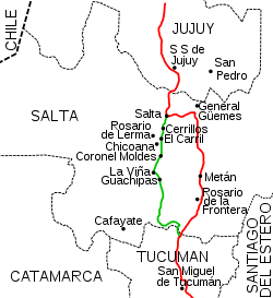
. In 1943 Buenos Aires Province transferred the road section Campana - San Nicolás under construction to the national government, making it part of National Route 9, along with the Buenos Aires - Campana section of Route 12. This way they shortened the road distance between the two most populous cities in Argentina. You can see in the map the new road layout of National Route 9 in red, and the old one in green.
In 1950 the Dirección Nacional de Vialidad (Public Works Dept) paved the Ramallo
Ramallo, Buenos Aires
Ramallo is a town in Buenos Aires Province, Argentina. It is the head town of the Ramallo Partido. It is located on next to the Río Paraná.-Economy:...
to San Nicolás de los Arroyos
San Nicolás de los Arroyos
San Nicolás de los Arroyos is a city in the province of Buenos Aires, Argentina, on the western shore of the Paraná River, 61 km from Rosario. It has about 138,000 inhabitants . It is the head town of the partido of the same name...
section, and between 1952 and 1953 they finished the Campana to Atucha section and in 1956 the road was fully paved from Buenos Aires to Rosario.
After the change of layout in 1979, the route was fully paved except for a short piece north of Humahuaca
Humahuaca
Humahuaca is a city in the province of Jujuy, Argentina. It has 11,369 inhabitants as per the , and is the principal town of the Department of Humahuaca...
, in Jujuy Province
Jujuy Province
Jujuy is a province of Argentina, located in the extreme northwest of the country, at the borders with Chile and Bolivia. The only neighboring Argentine province is Salta to the east and south.-History:...
, which was an improved road. Works to finalize the route started in 1997 and were extended until 30 April 2004, opening to the public on 21 January 2005.
Divided lanes
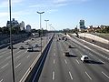
Buenos Aires - Rosario Highway
The section passing through Greater Buenos AiresGreater Buenos Aires
Greater Buenos Aires is the generic denomination to refer to the megalopolis comprising the autonomous city of Buenos Aires and the conurbation around it, over the province of Buenos Aires—namely the adjacent 24 partidos or municipalities—which nonetheless do not constitute a single administrative...
to the Port of Campana access road is part of Acceso Norte. The section between Avenida General Paz
Avenida General Paz
Avenida General Paz is a beltway freeway surrounding the city of Buenos Aires. Roughly following the boundary between the city and Buenos Aires Province, it is one of the few motorways in Argentina that is toll-free...
(Buenos Aires city border) to the start of National Route 8 is named Autopista Pascual Palazzo (by Decree 17/1981).
In 1943 the Dirección Nacional de Vialidad presented a plan for access to the city of Buenos Aires. Based on this plan, by the end of the forties work was started in what is known today as "Acceso Norte" (North Access) to Buenos Aires, reaching the town of Garín in 1959. In 1971 the section Garín-Campana was opened. In 1977 the Campana-Zárate highway was opened, allowing access to the Zárate-Brazo Largo Bridge
Zárate-Brazo Largo Bridge
The Zárate-Brazo Largo Bridges are two cable-stayed road and railway bridges in Argentina, crossing the Paraná River between the cities of Zárate, Buenos Aires Province, and Brazo Largo, Entre Ríos Province....
inaugurated that same year. In the year 1978 the section from San Nicolás de los Arroyos to Rosario was opened. This section is called "Teniente General Pedro Eugenio Aramburu
Pedro Eugenio Aramburu
Pedro Eugenio Aramburu Silveti was an Argentine Army General. Born in Río Cuarto, Córdoba on May 21, 1903. He was a major figure behind the military coup against Juan Perón in 1955. He became de facto president of Argentina from November 13, 1955 to May 1, 1958...
". (Decree 2,146/1979). In 1987 the last section of this highway was completed, between Campana and the Tala River.
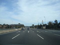
Rosario – Córdoba Highway
The Rosario – Córdoba highwayHighway
A highway is any public road. In American English, the term is common and almost always designates major roads. In British English, the term designates any road open to the public. Any interconnected set of highways can be variously referred to as a "highway system", a "highway network", or a...
project dates from 1970. On this project they would build a highway between these two cities over a new road, leaving the original road with one lane each way for local traffic, as it lies next to the Ferrocarril General Bartolomé Mitre
Ferrocarril General Bartolomé Mitre
Ferrocarril General Bartolomé Mitre , named after the former Argentine president Bartolomé Mitre, was one of the six state-owned Argentine railway companies formed after President Juan Perón's nationalisation of the railway network in 1948...
railroad, and traverses through the center of the different towns along its path.
On 12 November 1986, construction of the new highway between Córdoba and Villa María was bid, but the project never came to fruition. The highway was started by two of the contractor companies on this route in the 90s as part of the concession contracts. The agreement only included the sections from Avenida de Circunvalación de Córdoba
National Route A019 (Argentina)
National Route A019 is a beltway road around the city of Córdoba, capital of Córdoba Province in Argentina. When the final section on the northwest sector finishes construction, it will have a length of...
to Pilar and from Avenida de Circunvalación de Rosario
National Route A008 (Argentina)
National Route A008 is a beltway highway for the city of Rosario, Argentina. Built for traffic to avoid the congested city center, it allows drivers to bypass the city going around it in a much shorter time....
to Armstrong
Armstrong, Santa Fe
Armstrong is a city in the southwest of the province of Santa Fe, Argentina. It has 10,411 inhabitants as per the . It is located from the provincial capital Santa Fe, west of Rosario and from Cañada de Gómez, on National Route 9 near the intersection with National Route 178.The economy of the...
. On this last section, the Covicentro company only built the road to Carcarañá
Carcarañá
Carcarañá is a city in the , located in the San Lorenzo Department, on the southern banks of the Carcarañá River, west of Rosario on National Route 9, and south of the provincial capital...
.
In the year 2000 the national government opened a bid for the 109 km (68 mi) between Pilar and Villa María
Villa María
Villa María is a city in Córdoba Province, Argentina, and the head town of the General San Martín Department. It is located in the center of rich agricultural land. The area leads the country in production of milk...
, with the contract only covering one lane in the section from Oliva
Oliva, Córdoba
Oliva is a town in Córdoba Province in Argentina. It is the chief town of the Tercero Arriba Department....
to Villa María, with the winning bid from Benito Roggio e Hijos. In February 2006 the same group secured the contract from Oliva to Villa María and the 36 km (22 mi) from Villa María to Ballesteros, while the works on the 62 km (39 mi) between Ballesteros and Leones was given to the IECSA company, belonging to Grupo Macri.
On 3 May 2006, the national government opened the bidding process for the remaining sections of the highway in Santa Fe Province. The DYCASA company took charge of the section between Carcarañá and Armstrong, while a joint venture of Esuco and Chediack obtained the contracts for the highway between Armstrong and Tortugas...
The highway was fully inaugurated on 22 December 2010.
Salta Province
In the decade of the 2000s the section shared with National Route 34 in Salta Province became a four-lane road (two on each way).Right of way changes of 1979
The National Government by Decree 1595 in 1979 where several routes changed to provincial jurisdiction and viceversa, also changed the layout and right-of-way of some of them.Greater Buenos Aires
Greater Buenos Aires
Greater Buenos Aires is the generic denomination to refer to the megalopolis comprising the autonomous city of Buenos Aires and the conurbation around it, over the province of Buenos Aires—namely the adjacent 24 partidos or municipalities—which nonetheless do not constitute a single administrative...
, before the completion of the Accesso Norte, Route 9 ran through the present streets Boulogne Sur Mer, Presidente Sarmiento and Constituyentes Ave. in Tigre Partido
Tigre Partido
Tigre Partido is a partido or municipality of Buenos Aires Province, Argentina, situated in the north of Greater Buenos Aires. The department covers a large section of the Paraná Delta and its low-lying islands...
. This 15 km (9 mi) section from Don Torcuato and the border between Benavídez and Garín
Garin, Buenos Aires
Garin, Buenos Aires is located in Escobar, Buenos Aires, Argentina. Its geographical coordinates are 34° 25' 24" South, 58° 45' 43" West. Its a suburb of Buenos Aires.-References:*http://www.maplandia.com/argentina/buenos-aires/escobar/garin/...
left national jurisdiction by the aforementioned decree. Nowadays it is part of Provincial Route 9.
Buenos Aires - Santa Fe Province limits
Between San Nicolás de los ArroyosSan Nicolás de los Arroyos
San Nicolás de los Arroyos is a city in the province of Buenos Aires, Argentina, on the western shore of the Paraná River, 61 km from Rosario. It has about 138,000 inhabitants . It is the head town of the partido of the same name...
(Buenos Aires Province
Buenos Aires Province
The Province of Buenos Aires is the largest and most populous province of Argentina. It takes the name from the city of Buenos Aires, which used to be the provincial capital until it was federalized in 1880...
) and Rosario
Rosario
Rosario is the largest city in the province of Santa Fe, Argentina. It is located northwest of Buenos Aires, on the western shore of the Paraná River and has 1,159,004 residents as of the ....
(Santa Fe Province
Santa Fe Province
The Invincible Province of Santa Fe, in Spanish Provincia Invencible de Santa Fe , is a province of Argentina, located in the center-east of the country. Neighboring provinces are from the north clockwise Chaco , Corrientes, Entre Ríos, Buenos Aires, Córdoba, and Santiago del Estero...
), the road run closer to the Paraná River
Paraná River
The Paraná River is a river in south Central South America, running through Brazil, Paraguay and Argentina for some . It is second in length only to the Amazon River among South American rivers. The name Paraná is an abbreviation of the phrase "para rehe onáva", which comes from the Tupi language...
, northwest of the Ferrocarril General Bartolomé Mitre
Ferrocarril General Bartolomé Mitre
Ferrocarril General Bartolomé Mitre , named after the former Argentine president Bartolomé Mitre, was one of the six state-owned Argentine railway companies formed after President Juan Perón's nationalisation of the railway network in 1948...
railway. After construction of the San Nicolás de los Arroyos - Rosario highway southeast of said railway line at the end of the 1970s, this road changed to provincial control by the aforementioned decree. The transferred sections were 16.5 km (10.3 mi) in Buenos Aires Province (how secondary Provincial Route 098-06, also known as Presidente Illia access) and 68.8 km (42.8 mi) in Santa Fe Province (now Provincial Route 21).
Tucumán - Salta Province Limits
Salta Province
Salta is a province of Argentina, located in the northwest of the country. Neighboring provinces are from the east clockwise Formosa, Chaco, Santiago del Estero, Tucumán and Catamarca. It also surrounds Jujuy...
, 1 km (0.621372736649807 mi) north of the Salta-Tucumán border, the road turned to the west then north, turning into a mountain road, 104 km (65 mi) packed dirt until the town of La Viña. This section was transferred to Salta Province, changing its name to Provincial Route 6. Between the aforementioned town and the city of Salta, the road ran for 79 km (49 mi). This section remained under national jurisdiction, with the new name of National Route 68.
As of 2007 Provincial Route 6 is still unpaved and in some sections it is almost impassable.
On 30 October 1980 the Dirección Nacional de Vialidad and its provincial counterpart signed and agreement to transfer National Route 9 inside the city of Salta between the bridge over the Arenales river and Vidt street to provincial control. The agreement was ratified by de-facto provincial law.
The old road is shown in green and the new one in red in the map.
Distances and important cities
The following table shows the distances traversed by National Route 9 in each different province, and important cities that it passes by (or near).| Province | From | To | Length | Passes by |
|---|---|---|---|---|
| Buenos Aires | km 12 | km 237 | 225 km | Campana Campana, Buenos Aires Campana is a city in the Buenos Aires Province, Argentina, in the Campana Partido. It is located about from Buenos Aires City, on the right-hand margin of the Paraná River, Its population is 84,000 inhabitants as per the .... , Zárate Zárate, Buenos Aires Zárate is a city in the northeast of the . It lies on the western shore of the Paraná River, from Buenos Aires. Its population as per the is 101,271 inhabitants. It is the head town and the only city in the partido of the same name.... , San Nicolás de los Arroyos San Nicolás de los Arroyos San Nicolás de los Arroyos is a city in the province of Buenos Aires, Argentina, on the western shore of the Paraná River, 61 km from Rosario. It has about 138,000 inhabitants . It is the head town of the partido of the same name... |
| Santa Fe | km 237 | km 419 | 182 km | Villa Constitución Villa Constitución Villa Constitución is a city in the province of Santa Fe, Argentina, and the head town of the Constitución Department. It is located on the south-western banks of the Paraná River between the courses of the Arroyo Pavón and the Arroyo del Medio, about 214 km south from the provincial capital,... , Rosario Rosario Rosario is the largest city in the province of Santa Fe, Argentina. It is located northwest of Buenos Aires, on the western shore of the Paraná River and has 1,159,004 residents as of the .... , Cañada de Gómez Cañada de Gómez Cañada de Gómez is a city in the . It is the head town of the Iriondo Department and is located about west of Rosario and from the provincial capital, on National Route 9. It has a population of about 30,000 inhabitants .... |
| Córdoba | km 419 | km 910 | 491 km | Bell Ville Bell Ville Bell Ville is a city in center-south of the province of Córdoba, Argentina, located 200 km southeast from the capital Córdoba City, on the intersection of National Route 9 and Provincial Route 3 with the Córdoba–Rosario–Buenos Aires railroad.... , Villa María Villa María Villa María is a city in Córdoba Province, Argentina, and the head town of the General San Martín Department. It is located in the center of rich agricultural land. The area leads the country in production of milk... , Córdoba Córdoba, Argentina Córdoba is a city located near the geographical center of Argentina, in the foothills of the Sierras Chicas on the Suquía River, about northwest of Buenos Aires. It is the capital of Córdoba Province. Córdoba is the second-largest city in Argentina after the federal capital Buenos Aires, with... |
| Santiago del Estero | km 910 | km 1223 | 313 km | Santiago del Estero Santiago del Estero Santiago del Estero is the capital of Santiago del Estero Province in northern Argentina. It has a population of 244,733 inhabitants, making it the twelfth largest city in the country, with a surface area of 2,116 km². It lies on the Dulce River and on National Route 9, at a distance of... , Termas de Río Hondo Termas de Río Hondo Termas de Río Hondo is a city in the province of Santiago del Estero, Argentina. It has 27,838 inhabitants as per the . It is located on the banks of the Dulce River, 65 km north of the provincial capital Santiago del Estero, near the artificial Río Hondo Lake.... |
| Tucumán | km 1223 | km 1371 | 148 km | San Miguel de Tucumán |
| Salta | km 1371 | km 1648 | 277 km | Rosario de la Frontera Rosario de la Frontera Rosario de la Frontera is a city in the center-south of the province of Salta, Argentina. It has 24,819 inhabitants as per the , and is the head town of the Rosario de la Frontera Department. It is located on National Route 9, by the Horcones River.... , General Güemes General Güemes, Salta General Güemes is a city in the center of the province of Salta, Argentina. It has 29,168 inhabitants as per the , and is the head town of the General Güemes Department. It lies about 45 km west-northwest from the provincial capital Salta, on National Route 9... , Salta Salta Salta is a city in northwestern Argentina and the capital city of the Salta Province. Along with its metropolitan area, it has a population of 464,678 inhabitants as of the , making it Argentina's eighth largest city.-Overview:... |
| Jujuy | km 1648 | km 1979 | 318 km | San Salvador de Jujuy San Salvador de Jujuy San Salvador de Jujuy , commonly known as Jujuy and locally often referred to as San Salvador, is the capital city of Jujuy Province in northwest Argentina. It lies near the southern end of the Humahuaca Canyon where wooded hills meet the lowlands.... , Humahuaca Humahuaca Humahuaca is a city in the province of Jujuy, Argentina. It has 11,369 inhabitants as per the , and is the principal town of the Department of Humahuaca... , La Quiaca La Quiaca La Quiaca is a small city in the north of the , on the southern bank of the La Quiaca River, opposite the town of Villazón, Bolivia. It lies at the end of National Route 9, from San Salvador de Jujuy , and at an altitude of above mean sea level.La Quiaca has 14,751 inhabitants as per the... |
See also
- Pan-American HighwayPan-American HighwayThe Pan-American Highway is a network of roads measuring about in total length. Except for an rainforest break, called the Darién Gap, the road links the mainland nations of the Americas in a connected highway system. According to Guinness World Records, the Pan-American Highway is the world's...