
Avenida General Paz
Encyclopedia
Buenos Aires
Buenos Aires is the capital and largest city of Argentina, and the second-largest metropolitan area in South America, after São Paulo. It is located on the western shore of the estuary of the Río de la Plata, on the southeastern coast of the South American continent...
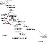
. Roughly following the boundary between the city and Buenos Aires Province
Buenos Aires Province
The Province of Buenos Aires is the largest and most populous province of Argentina. It takes the name from the city of Buenos Aires, which used to be the provincial capital until it was federalized in 1880...
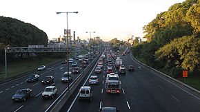
, it is one of the few motorways in Argentina that is toll-free. It carries three lanes of traffic in each direction during most of its length, and five lanes between the Pan-American Highway
Pan-American Highway
The Pan-American Highway is a network of roads measuring about in total length. Except for an rainforest break, called the Darién Gap, the road links the mainland nations of the Americas in a connected highway system. According to Guinness World Records, the Pan-American Highway is the world's...
and the Río de la Plata
Río de la Plata
The Río de la Plata —sometimes rendered River Plate in British English and the Commonwealth, and occasionally rendered [La] Plata River in other English-speaking countries—is the river and estuary formed by the confluence of the Uruguay River and the Paraná River on the border between Argentina and...
. There are feeder roads in both directions and there are service areas along its length, usually with a gas station and fast food restaurants.
History
Federal law number 2,089 of 1887 established the limits of the city of Buenos AiresBuenos Aires
Buenos Aires is the capital and largest city of Argentina, and the second-largest metropolitan area in South America, after São Paulo. It is located on the western shore of the estuary of the Río de la Plata, on the southeastern coast of the South American continent...
, including the Partido
Partido
A partido is an administrative subdivision of the . They are formally considered to be a single municipality, and usually contain one or more population centers...
s of Belgrano and San José de Flores. In Article 6 it declared that a road was to be built to delimit these with the city of Buenos Aires. Due to the plan of drawing straight lines for the road, an exchange of land was made between the Capital Federal and Buenos Aires Province
Buenos Aires Province
The Province of Buenos Aires is the largest and most populous province of Argentina. It takes the name from the city of Buenos Aires, which used to be the provincial capital until it was federalized in 1880...
.
Named after José María Paz
José María Paz
Brigadier General José María Paz y Haedo was an Argentine military figure, notable in the Argentine War of Independence and the Argentine Civil War.-Childhood:...
, the freeway was designed by Pascual Palazzo and construction was directed by José María Zaballa Carbó. It was the first freeway built in the country. The crossings with the most important avenues were grade-separated; more minor cross-streets were served with traffic circle
Traffic circle
A traffic circle or rotary is a type of circular intersection in which traffic must travel in one direction around a central island. In some countries, traffic entering the circle has the right-of-way and drivers in the circle must yield. In many other countries, traffic entering the circle must...
s. The road had four lanes, two on each direction and lateral feeder streets of one lane on each side. The pavement was made of reinforced concrete
Reinforced concrete
Reinforced concrete is concrete in which reinforcement bars , reinforcement grids, plates or fibers have been incorporated to strengthen the concrete in tension. It was invented by French gardener Joseph Monier in 1849 and patented in 1867. The term Ferro Concrete refers only to concrete that is...
.
Cloverleaf interchange
A cloverleaf interchange is a two-level interchange in which left turns, reverse direction in left-driving regions, are handled by ramp roads...
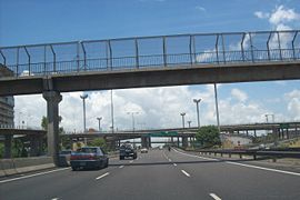
In 1996 the road was modernized and fully grade-separated, widening the road to three lanes on each direction and two feeder streets with two lanes each. To facilitate traffic it was decided that the colectivo
Colectivo
Colectivo is the name given in Argentina and Paraguay to a type of public transportation vehicles, especially those of Argentina's capital city, Buenos Aires...
bus lines travelled on these feeder roads, except the express service buses
Express bus
An express bus service is a bus service that is intended to run faster than normal bus services between the same two commuter points....
, which stop on these feeders. These streets have speed bumps of limit speed to 40 kilometers per hour (25 mph).