
Mara Rosa
Encyclopedia
| Mara Rosa | |
|---|---|
| State | Goiás Goiás Goiás is a state of Brazil, located in the central part of the country. The name Goiás comes from the name of an indigenous community... |
| Area: | 1,704 km² |
| Population: | 10,409 (IBGE 2007) |
| Elevation: | 530 m above sea level |
| Postcode (CEP): | 76490-000 |
| Became a city: | 1953 |
| Distance to Goiânia Goiânia -Climate:The city has a tropical wet and dry climate with an average temperature of . There's a wet season, from October to April, and a dry one, from May to September. Annual rainfall is around 1,520 mm.... : |
356 km. |
| IBGE statistical microregion: | Porangatu Microregion Porangatu Microregion The Porangatu Microregion is a statistical region created by IBGE in north-central Goiás state, Brazil. The most important city is Porangatu... |
| Website: | none |
Town
A town is a human settlement larger than a village but smaller than a city. The size a settlement must be in order to be called a "town" varies considerably in different parts of the world, so that, for example, many American "small towns" seem to British people to be no more than villages, while...
and municipality
Municipality
A municipality is essentially an urban administrative division having corporate status and usually powers of self-government. It can also be used to mean the governing body of a municipality. A municipality is a general-purpose administrative subdivision, as opposed to a special-purpose district...
in north-central Goiás
Goiás
Goiás is a state of Brazil, located in the central part of the country. The name Goiás comes from the name of an indigenous community...
state, Brazil
Brazil
Brazil , officially the Federative Republic of Brazil , is the largest country in South America. It is the world's fifth largest country, both by geographical area and by population with over 192 million people...
.
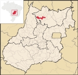
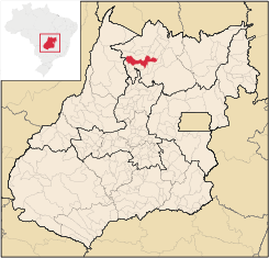
Location
Mara Rosa is located 356 kilometers north of GoiâniaGoiânia
-Climate:The city has a tropical wet and dry climate with an average temperature of . There's a wet season, from October to April, and a dry one, from May to September. Annual rainfall is around 1,520 mm....
in the Porangatu Microregion
Porangatu Microregion
The Porangatu Microregion is a statistical region created by IBGE in north-central Goiás state, Brazil. The most important city is Porangatu...
. It is 11 kilometers east of the Belém-Brasília highway, between the basins of the Araguaia River
Araguaia River
The Araguaia River or, in Portuguese, Rio Araguaia is one of the major rivers of Brazil, and the principal tributary of the Tocantins. It has a total length of approximately 2,627 km. Araguaia means "river of macaws" in the Tupi language....
and the Tocantins River
Tocantins River
The Tocantins is a river in Brazil, the central fluvial artery of the country. In the Tupi language, its name means "toucan's beak" . It runs from south to north for about 2,640 km. It is not really a branch of the Amazon River, although usually so considered, since its waters flow into the...
. Neighboring municipalities are: Alto Horizonte
Alto Horizonte
Alto Horizonte is a small town and municipality in north Goiás state, Brazil. The population was 3,136 in 2007 and the area of the municipality was 503.7 km².-Location:...
, Amaralina
Amaralina
Amaralina is a small town and municipality in north Goiás state, Brazil.-Location:*Distance from Goiânia: 485 km.*Highway access from Goiânia: GO-080 / Nerópolis / BR-153 / Jaraguá / GO-080 / Goianésia / Barro Alto / GO-342 / Uruaçu / Campinorte / GO-329.Amaralina is surrounded by the...
, Campinorte
Campinorte
Campinorte is a small city and municipality in north-central Goiás state, Brazil. The population was 9,697 in a total area of 1,068 km².-Location:...
, Campos Verdes de Goiás, Estrela do Norte
Estrela do Norte
Estrela do Norte refers to:*A municipality in the state of São Paulo, Brazil. See Estrela do Norte, São Paulo.*A municipality in the state of Goiás, Brazil. See Estrela do Norte, Goiás.*A football club from Cachoeiro de Itapemirim, Brazil....
, Formoso
Formoso
Formoso is a small town and municipality in north Goiás state, Brazil. The population was 5,241 in a total area of 844 km².Highway connections from Goiânia are made by GO-080 / Nerópolis / São Francisco de Goiás / BR-153 / Jaraguá / GO-080 / Goianésia / Barro Alto / GO-342 / BR-080 / BR-153 /...
, Mutunópolis
Mutunópolis
Mutunópolis is a small town and municipality in north Goiás state, Brazil.-Location:Mutunópolis is located in the extreme north of the state, 38 km south of the important regional center of Porangatu...
, Nova Iguaçu de Goiás
Nova Iguaçu de Goiás
Nova Iguaçu de Goiás is a small town and municipality in north Goiás state, Brazil.-Location:Nova Iguaçu de Goiás is located in the extreme north of the state and is 136 km from the regional center of Porangatu. Other towns nearby are Campinorte, 28 km. to the east; Alto Horizonte,...
, Santa Terezinha de Goiás
Santa Terezinha de Goiás
Santa Terezinha de Goiás is a small city and municipality in north Goiás state, Brazil. Santa Terezinha is sometimes written as ""Santa Teresinha".-Location:...
, and Uirapuru
Uirapuru
Uirapuru is a small town and municipality in northwestern Goiás state, Brazil.-Location:Uirapuru is in the São Miguel do Araguaia Microregion, west of the important BR-153 highway. It is connected by a paved road to Crixás, 35 kilometers to the south. The distance to the state capital, Goiânia,...
.
Highway communications with Goiânia
Goiânia
-Climate:The city has a tropical wet and dry climate with an average temperature of . There's a wet season, from October to April, and a dry one, from May to September. Annual rainfall is around 1,520 mm....
are made by GO-080 / Nerópolis
Nerópolis
Nerópolis is a small city and municipality in central Goiás state, Brazil.-Location:The municipality is part of the metropolitan region of Goiânia, which is 42 kilometers to the west. It is nationally known as the city of garlic and sweets...
/ São Francisco de Goiás
São Francisco de Goiás
São Francisco de Goiás is a small town and municipality in central Goiás state, Brazil.Municipal boundaries:*North: Jaraguá*South: Petrolina de Goiás*East: Pirenópolis*West: Jesúpolis and Jaraguá...
/ BR-153 / Jaraguá / GO-080 / Goianésia
Goianésia
Goianésia is a municipality in the state of Goiás, Brazil. It is a large producer of sugarcane for production of alcohol used as a source of fuel.-Location:...
/ Barro Alto
Barro Alto
Barro Alto is a small town and municipality in northern Goiás state, Brazil, famous for its nickel mine and production of rubber. The population was 6,446 in 2007 and the total area of the municipality was 1,231.8 km².-Location:...
/ GO-342 / BR-153 / Uruaçu
Uruaçu
Uruaçu is a small city and municipality in north Goiás state, Brazil.-Geography:Uruaçu is located north of Anápolis and Goiânia on the important interstate highway BR-153, which links Brasília to Belém. It is 269 km. from Goiânia and 244 km. from Brasília...
/ Campinorte
Campinorte
Campinorte is a small city and municipality in north-central Goiás state, Brazil. The population was 9,697 in a total area of 1,068 km².-Location:...
/ GO-239.
History
Mara Rosa is considered one of the oldest municipalities in the state. The discovery of gold took many people to the region. The first houses appeared in 1742, 15 years after the founding of Vila Boa, the former capital of the state. The first name was Amaro Leite, a tribute to its founder, Amaro Leite Moreira. The district of Amaro Leite belonged to the Comarca de Pilar in 1911. In 1933 it was a district of Santana de Uruaçu. In 1953 it separated from UruaçuUruaçu
Uruaçu is a small city and municipality in north Goiás state, Brazil.-Geography:Uruaçu is located north of Anápolis and Goiânia on the important interstate highway BR-153, which links Brasília to Belém. It is 269 km. from Goiânia and 244 km. from Brasília...
to become the city of Amaro Leite. This settlement was transferred to another site and in 1960 the name was changed to Mara Rosa as a tribute to José Maurício de Moura.
Political information
In January 2005 the mayor was Otávio Alves Neto and the vice-mayor was Ostervaldo Gomes de Aguiar. There were 9 members of the city council and the number of eligible voters was 8,347 in December 2007.Demographic information
The population density was 6.11 inhabitants/km² in 2007. The population has decreased greatly since 1980, when it was 21,524. From 1996 to 2007 the decrease was 3.19%. Most of this decrease has been in the rural area. In 1980 the rural population was 16,309 and by 2007 it had decreased to 2,700. Most of these people did not move into the town itself but most likely immigrated to the large urban centers of AnápolisAnápolis
Anápolis is the third largest city in the State of Goiás in Brazil. It lies in the center of a rich agricultural region and has become a leader in food processing and pharmaceutical plants.-Location and population:...
, Goiânia
Goiânia
-Climate:The city has a tropical wet and dry climate with an average temperature of . There's a wet season, from October to April, and a dry one, from May to September. Annual rainfall is around 1,520 mm....
, and Brasília
Brasília
Brasília is the capital city of Brazil. The name is commonly spelled Brasilia in English. The city and its District are located in the Central-West region of the country, along a plateau known as Planalto Central. It has a population of about 2,557,000 as of the 2008 IBGE estimate, making it the...
.
Economy
There are deposits of phosphates, lead, copper, gold, and silver. Mara Rosa is the biggest producer of saffron in the state of GoiásGoiás
Goiás is a state of Brazil, located in the central part of the country. The name Goiás comes from the name of an indigenous community...
and there are also important plantations of corn, soybeans, and rice. There are small industries producing cheese and furniture. In 2006 there 902 farms with 5,448 hectares of planted area and 76,000 hectares of pasture. Approximately 2,300 persons were dependent on the farming sector in 2005.
In 2007 there were 21 industrial units and 124 retail units. There was one dairy--Laticínios Mara Rosa Ltda. There was one bank institution--Banco do Brasil S.A. The biggest employer was the retail sector with 255 workers in 2006. There were 713 automobiles in 2007.
The cattle herd was quite large with 120,000 head in 2006. The main agricultural products in planted area were corn with 2,000 hectares in 2006 . Other crops were manioc, rice, sugarcane, soybeans, and bananas. Saffron has become a planting option in recent years.
Health and education
In 2007 there were 2 hospitals with 31 beds and 6 walk-in health clinics. The infant mortality rate was 27.56 in 2000.In 2006 there were 11 schools with 3,282 students. There were no courses in higher education. The adult literacy rate was 82.3% in 2000.
- 2000 Municipal Human Development IndexHuman Development IndexThe Human Development Index is a composite statistic used to rank countries by level of "human development" and separate "very high human development", "high human development", "medium human development", and "low human development" countries...
: 0.713 - State ranking: 192 (out of 246 municipalities)
- National ranking: 2,757 (out of 5,507 municipalities)