
Florida, Massachusetts
Encyclopedia
Florida is a town
in Berkshire County
, Massachusetts
, United States
. It is part of the Pittsfield
, Massachusetts
Metropolitan Statistical Area. The population was 676 at the 2000 census. It is home to the east portal of the Hoosac Tunnel
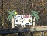
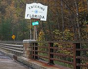
, as well as Whitcomb Summit (elevation 2,172 feet), the highest point of the Mohawk Trail
. Florida also contains the village of Drury.
, made sometime before 1771. The first settler, Dr. Daniel Nelson, arrived around 1783. The town was incorporated in 1805 and named Florida, perhaps because Spanish Florida
was a topic of conversation at the time.
The town was mostly agrarian, with maple syrup, wool and potatoes being the main products of the town for many years. However, in the mid-nineteenth century, the town was a boom town for the workers involved in the construction of the Hoosac Tunnel
, a rail tunnel which begins on the town's eastern border and extends through the Hoosac Range to neighboring North Adams. Today the town is sparsely populated, with most residents working in neighboring towns.
, the town has a total area of 24.6 square miles (63.7 km²), of which 24.4 square miles (63.2 km²) is land and 0.2 square mile (0.517997622 km²) (0.81%) is water.
Florida is located at 42° 39'57.77"N, 72° 56'29.38"W. Florida is bordered on the north by Stamford
, Vermont
, on the northeast by Monroe
, on the east by Rowe
, on the southeast by Charlemont
, on the south by Savoy
, on the southwest by Adams
, and on the west by North Adams
and Clarksburg
. The town's population is mostly concentrated along the Mohawk Trail
, which runs through the town, and its villages, Drury, Florida and Whitcomb Summit.
Florida is located near the highest points of the Hoosac Range
, which runs through the western part of town. There are several rivers and brooks, most of which lead to the Deerfield River
, which forms much of the eastern border. The town includes parts of three state forests - Monroe State Forest in the northeast, Savoy Mountain State Forest in the south, and Mohawk Trail State Forest in the southeast. The highest elevation in the town is 2830 feet (862.6 m) above sea level, on an unnamed hill northwest of Crum Hill in the neighboring town of Monroe.
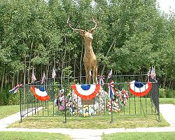
 Route 2, also known as the Mohawk Trail, runs from the southeast of town through to the west. Whitcomb Summit, near the western border of town, is the highest point along the trail, and has an observatory, as well as a monument to the Elks Club, whose members helped modernize the trails and worked on the Hoosac Tunnel. Just west of the town is the West Summit, which offers spectacular views of the Hoosic River Valley and the Taconic Range further west. There are no other state routes through town, and the nearest interstate highway is Interstate 91
to the east.
The Hoosac Tunnel carries the railway under the town, and as such has no stops in town. The nearest regional bus service can be found in North Adams, as can the nearest regional airport, Harriman-and-West Airport
. The nearest airport with national flights is Albany International Airport
.
of 2000, there were 676 people, 265 households, and 196 families residing in the town. Florida's population ranks 27th out of the 32 towns in Berkshire County, and 337th out of the 351 cities and towns in Massachusetts. The population density
was 27.7 people per square mile (10.7/km²), making it the 24th most densely populated town in the county, and 333rd in the Commonwealth. There were 294 housing units at an average density of 12.1 per square mile (4.7/km²). The racial makeup of the town was 97.49% White, 0.59% African American, 0.44% Native American, 0.44% Asian, 0.30% from other races
, and 0.74% from two or more races. Hispanic or Latino of any race were 0.44% of the population.
There were 265 households out of which 32.8% had children under the age of 18 living with them, 65.7% were married couples
living together, 4.9% had a female householder with no husband present, and 25.7% were non-families. 22.6% of all households were made up of individuals and 9.8% had someone living alone who was 65 years of age or older. The average household size was 2.55 and the average family size was 2.99.
In the town the population was spread out with 25.1% under the age of 18, 4.3% from 18 to 24, 30.8% from 25 to 44, 25.9% from 45 to 64, and 13.9% who were 65 years of age or older. The median age was 40 years. For every 100 females there were 109.3 males. For every 100 females age 18 and over, there were 107.4 males.
The median income for a household in the town was $43,000, and the median income for a family was $52,500. Males had a median income of $32,000 versus $23,906 for females. The per capita income
for the town was $16,979. About 3.3% of families and 5.8% of the population were below the poverty line, including 7.3% of those under age 18 and 8.6% of those age 65 or over.
 Florida is governed by an open town meeting
form of government, which is led by a board of selectmen
and a town secretary. The town has its own services, including fire and public works, as well as the Florida Free Library, a small library with association to the regional library services. The nearest hospital, North Adams Regional Hospital, is located in neighboring North Adams.
On the state level, Florida is represented in the Massachusetts House of Representatives
by the First Berkshire district, which covers northern Berkshire County, as well as portions of Franklin County. In the Massachusetts Senate
, the town is represented by the Berkshire, Hampshire and Franklin district, which includes all of Berkshire County and western Hampshire and Franklin Counties. The town's police services are provided by the Fourth (Cheshire) Station of Troop B of the Massachusetts State Police
.
On the national level, Florida is represented in the United States House of Representatives
as part of Massachusetts's 1st congressional district
, and has been represented by John Olver
of Amherst
since June 1991. Massachusetts is currently represented in the United States Senate
by senior Senator John Kerry
and junior senator Scott Brown
.
or Charles H. McCann Technical High School
, both of which are in North Adams.
The nearest community college is Berkshire Community College
, located in Pittsfield. The nearest public college is Massachusetts College of Liberal Arts
in neighboring North Adams, and the nearest university is the University of Massachusetts Amherst
. The nearest private college is Williams College
in Williamstown.
New England town
The New England town is the basic unit of local government in each of the six New England states. Without a direct counterpart in most other U.S. states, New England towns are conceptually similar to civil townships in other states, but are incorporated, possessing powers like cities in other...
in Berkshire County
Berkshire County, Massachusetts
Berkshire County is a non-governmental county located on the western edge of the U.S. state of Massachusetts. As of the 2010 census, the population was 131,219. Its largest city and traditional county seat is Pittsfield...
, Massachusetts
Massachusetts
The Commonwealth of Massachusetts is a state in the New England region of the northeastern United States of America. It is bordered by Rhode Island and Connecticut to the south, New York to the west, and Vermont and New Hampshire to the north; at its east lies the Atlantic Ocean. As of the 2010...
, United States
United States
The United States of America is a federal constitutional republic comprising fifty states and a federal district...
. It is part of the Pittsfield
Pittsfield, Massachusetts
Pittsfield is the largest city and the county seat of Berkshire County, Massachusetts, United States. It is the principal city of the Pittsfield, Massachusetts Metropolitan Statistical Area which encompasses all of Berkshire County. Its area code is 413. Its ZIP code is 01201...
, Massachusetts
Massachusetts
The Commonwealth of Massachusetts is a state in the New England region of the northeastern United States of America. It is bordered by Rhode Island and Connecticut to the south, New York to the west, and Vermont and New Hampshire to the north; at its east lies the Atlantic Ocean. As of the 2010...
Metropolitan Statistical Area. The population was 676 at the 2000 census. It is home to the east portal of the Hoosac Tunnel
Hoosac Tunnel
The Hoosac Tunnel is a 4.75-mile-long railroad tunnel in western Massachusetts which passes through the Hoosac Range, an extension of Vermont's Green Mountains. Work began in 1848 and was finally completed in 1875...
, as well as Whitcomb Summit (elevation 2,172 feet), the highest point of the Mohawk Trail
Mohawk Trail
- External links :* *...
. Florida also contains the village of Drury.
History
Most of what is now Florida was originally a grant to the town of Bernardston, MassachusettsBernardston, Massachusetts
Bernardston is a town in Franklin County, Massachusetts, United States. The population was 2,155 at the 2000 census. It is part of the Springfield, Massachusetts Metropolitan Statistical Area.- History :...
, made sometime before 1771. The first settler, Dr. Daniel Nelson, arrived around 1783. The town was incorporated in 1805 and named Florida, perhaps because Spanish Florida
Florida
Florida is a state in the southeastern United States, located on the nation's Atlantic and Gulf coasts. It is bordered to the west by the Gulf of Mexico, to the north by Alabama and Georgia and to the east by the Atlantic Ocean. With a population of 18,801,310 as measured by the 2010 census, it...
was a topic of conversation at the time.
The town was mostly agrarian, with maple syrup, wool and potatoes being the main products of the town for many years. However, in the mid-nineteenth century, the town was a boom town for the workers involved in the construction of the Hoosac Tunnel
Hoosac Tunnel
The Hoosac Tunnel is a 4.75-mile-long railroad tunnel in western Massachusetts which passes through the Hoosac Range, an extension of Vermont's Green Mountains. Work began in 1848 and was finally completed in 1875...
, a rail tunnel which begins on the town's eastern border and extends through the Hoosac Range to neighboring North Adams. Today the town is sparsely populated, with most residents working in neighboring towns.
Geography
According to the United States Census BureauUnited States Census Bureau
The United States Census Bureau is the government agency that is responsible for the United States Census. It also gathers other national demographic and economic data...
, the town has a total area of 24.6 square miles (63.7 km²), of which 24.4 square miles (63.2 km²) is land and 0.2 square mile (0.517997622 km²) (0.81%) is water.
Florida is located at 42° 39'57.77"N, 72° 56'29.38"W. Florida is bordered on the north by Stamford
Stamford, Vermont
Stamford is a town in Bennington County, Vermont, United States. The population was 813 at the 2000 census.-Geography:Stamford is located near the southwestern corner of Vermont, on the Massachusetts state line. To the south of Stamford lie Clarksburg, Massachusetts and Florida, Massachusetts...
, Vermont
Vermont
Vermont is a state in the New England region of the northeastern United States of America. The state ranks 43rd in land area, , and 45th in total area. Its population according to the 2010 census, 630,337, is the second smallest in the country, larger only than Wyoming. It is the only New England...
, on the northeast by Monroe
Monroe, Massachusetts
Monroe is a town in Franklin County, Massachusetts, United States. The population was 93 at the 2000 census. By area, population and population density, it is the smallest town in the county; and is the second-smallest town by population in the Commonwealth, with only Gosnold having fewer...
, on the east by Rowe
Rowe, Massachusetts
Rowe is a town in Franklin County, Massachusetts, United States. The population was 351 at the 2000 census. It is part of the Springfield, Massachusetts Metropolitan Statistical Area.-History:...
, on the southeast by Charlemont
Charlemont, Massachusetts
Charlemont is a town in Franklin County, Massachusetts, United States. The population was 1,358 at the 2000 census. It is part of the Springfield, Massachusetts Metropolitan Statistical Area.- History :...
, on the south by Savoy
Savoy, Massachusetts
Savoy is a town in Berkshire County, Massachusetts, United States. It is part of the Pittsfield, Massachusetts Metropolitan Statistical Area. The population was 705 at the 2000 census.- History :...
, on the southwest by Adams
Adams, Massachusetts
Adams is a town in Berkshire County, Massachusetts, United States. It is part of the Pittsfield, Massachusetts Metropolitan Statistical Area. The population was 8,485 at the 2010 census.-History:...
, and on the west by North Adams
North Adams, Massachusetts
North Adams is a city in Berkshire County, Massachusetts, United States. It is part of the Pittsfield, Massachusetts Metropolitan Statistical Area. The population was 13,708 as of the 2010 census, making it the least populous city in the state...
and Clarksburg
Clarksburg, Massachusetts
Clarksburg is a town in Berkshire County, Massachusetts, United States. It is part of the Pittsfield, Massachusetts Metropolitan Statistical Area...
. The town's population is mostly concentrated along the Mohawk Trail
Mohawk Trail
- External links :* *...
, which runs through the town, and its villages, Drury, Florida and Whitcomb Summit.
Florida is located near the highest points of the Hoosac Range
Hoosac Range
The Hoosac Range is part of both the Berkshires of western Massachusetts and the southern Green Mountains of Vermont; it is part of the greater Appalachian Mountain chain...
, which runs through the western part of town. There are several rivers and brooks, most of which lead to the Deerfield River
Deerfield River
Deerfield River is a river that runs for from southern Vermont through northwestern Massachusetts to the Connecticut River. The Deerfield was historically influential in the settlement of western Franklin County, Massachusetts, and its namesake town...
, which forms much of the eastern border. The town includes parts of three state forests - Monroe State Forest in the northeast, Savoy Mountain State Forest in the south, and Mohawk Trail State Forest in the southeast. The highest elevation in the town is 2830 feet (862.6 m) above sea level, on an unnamed hill northwest of Crum Hill in the neighboring town of Monroe.
Interstate 91
Interstate 91 is an Interstate Highway in the New England region of the United States. It provides the primary north–south thoroughfare in the western part of New England...
to the east.
The Hoosac Tunnel carries the railway under the town, and as such has no stops in town. The nearest regional bus service can be found in North Adams, as can the nearest regional airport, Harriman-and-West Airport
Harriman-and-West Airport
Harriman-and-West Airport , also known as Harriman & West or Harriman-West, is a public airport located three miles west of the central business district of North Adams, a city in Berkshire County, Massachusetts, United States. It is owned by the City of North Adams and is operated by a five...
. The nearest airport with national flights is Albany International Airport
Albany International Airport
Albany International Airport is a public use airport located six nautical miles northwest of the central business district of Albany, in Albany County, New York, United States. It is owned by the Albany County Airport Authority....
.
Demographics
As of the censusCensus
A census is the procedure of systematically acquiring and recording information about the members of a given population. It is a regularly occurring and official count of a particular population. The term is used mostly in connection with national population and housing censuses; other common...
of 2000, there were 676 people, 265 households, and 196 families residing in the town. Florida's population ranks 27th out of the 32 towns in Berkshire County, and 337th out of the 351 cities and towns in Massachusetts. The population density
Population density
Population density is a measurement of population per unit area or unit volume. It is frequently applied to living organisms, and particularly to humans...
was 27.7 people per square mile (10.7/km²), making it the 24th most densely populated town in the county, and 333rd in the Commonwealth. There were 294 housing units at an average density of 12.1 per square mile (4.7/km²). The racial makeup of the town was 97.49% White, 0.59% African American, 0.44% Native American, 0.44% Asian, 0.30% from other races
Race (United States Census)
Race and ethnicity in the United States Census, as defined by the Federal Office of Management and Budget and the United States Census Bureau, are self-identification data items in which residents choose the race or races with which they most closely identify, and indicate whether or not they are...
, and 0.74% from two or more races. Hispanic or Latino of any race were 0.44% of the population.
There were 265 households out of which 32.8% had children under the age of 18 living with them, 65.7% were married couples
Marriage
Marriage is a social union or legal contract between people that creates kinship. It is an institution in which interpersonal relationships, usually intimate and sexual, are acknowledged in a variety of ways, depending on the culture or subculture in which it is found...
living together, 4.9% had a female householder with no husband present, and 25.7% were non-families. 22.6% of all households were made up of individuals and 9.8% had someone living alone who was 65 years of age or older. The average household size was 2.55 and the average family size was 2.99.
In the town the population was spread out with 25.1% under the age of 18, 4.3% from 18 to 24, 30.8% from 25 to 44, 25.9% from 45 to 64, and 13.9% who were 65 years of age or older. The median age was 40 years. For every 100 females there were 109.3 males. For every 100 females age 18 and over, there were 107.4 males.
The median income for a household in the town was $43,000, and the median income for a family was $52,500. Males had a median income of $32,000 versus $23,906 for females. The per capita income
Per capita income
Per capita income or income per person is a measure of mean income within an economic aggregate, such as a country or city. It is calculated by taking a measure of all sources of income in the aggregate and dividing it by the total population...
for the town was $16,979. About 3.3% of families and 5.8% of the population were below the poverty line, including 7.3% of those under age 18 and 8.6% of those age 65 or over.
Government
Open town meeting
An open town meeting is a form of town meeting in which all registered voters of a town may vote . This form of government is typical of smaller municipalities in the New England region of the United States....
form of government, which is led by a board of selectmen
Board of selectmen
The board of selectmen is commonly the executive arm of the government of New England towns in the United States. The board typically consists of three or five members, with or without staggered terms.-History:...
and a town secretary. The town has its own services, including fire and public works, as well as the Florida Free Library, a small library with association to the regional library services. The nearest hospital, North Adams Regional Hospital, is located in neighboring North Adams.
On the state level, Florida is represented in the Massachusetts House of Representatives
Massachusetts House of Representatives
The Massachusetts House of Representatives is the lower house of the Massachusetts General Court, the state legislature of the Commonwealth of Massachusetts. It is composed of 160 members elected from single-member electoral districts across the Commonwealth. Representatives serve two-year terms...
by the First Berkshire district, which covers northern Berkshire County, as well as portions of Franklin County. In the Massachusetts Senate
Massachusetts Senate
The Massachusetts Senate is the upper house of the Massachusetts General Court, the bicameral state legislature of the Commonwealth of Massachusetts. The Senate comprises 40 elected members from 40 single-member senatorial districts in the state...
, the town is represented by the Berkshire, Hampshire and Franklin district, which includes all of Berkshire County and western Hampshire and Franklin Counties. The town's police services are provided by the Fourth (Cheshire) Station of Troop B of the Massachusetts State Police
Massachusetts State Police
The Massachusetts State Police is an agency of the Commonwealth of Massachusetts' Executive Office of Public Safety and Security responsible for criminal law enforcement and traffic vehicle regulation across the state...
.
On the national level, Florida is represented in the United States House of Representatives
United States House of Representatives
The United States House of Representatives is one of the two Houses of the United States Congress, the bicameral legislature which also includes the Senate.The composition and powers of the House are established in Article One of the Constitution...
as part of Massachusetts's 1st congressional district
Massachusetts's 1st congressional district
Massachusetts's 1st congressional district is in western and central Massachusetts. The largest Massachusetts district in area, it covers about one-third of the state and is more rural than the rest. It has the state's highest point, Mount Greylock...
, and has been represented by John Olver
John Olver
John Walter Olver is the U.S. Representative for , serving since 1991. He is a member of the Democratic Party. Early in his career, he was a chemistry professor and served in both chambers of the Massachusetts General Court....
of Amherst
Amherst, Massachusetts
Amherst is a town in Hampshire County, Massachusetts, United States in the Connecticut River valley. As of the 2010 census, the population was 37,819, making it the largest community in Hampshire County . The town is home to Amherst College, Hampshire College, and the University of Massachusetts...
since June 1991. Massachusetts is currently represented in the United States Senate
United States Senate
The United States Senate is the upper house of the bicameral legislature of the United States, and together with the United States House of Representatives comprises the United States Congress. The composition and powers of the Senate are established in Article One of the U.S. Constitution. Each...
by senior Senator John Kerry
John Kerry
John Forbes Kerry is the senior United States Senator from Massachusetts, the 10th most senior U.S. Senator and chairman of the Senate Foreign Relations Committee. He was the presidential nominee of the Democratic Party in the 2004 presidential election, but lost to former President George W...
and junior senator Scott Brown
Scott Brown
Scott Brown is a United States senator.Scott Brown may also refer to:-Sportsmen:*Scott Brown , American college football coach of Kentucky State...
.
Education
Florida has one school, the Gabriel Abbott Memorial School, which serves students from kindergarten through eighth grade. The school also serves the students of neighboring Monroe. The town sends its high school students to either Drury High SchoolDrury High School
Drury High SchoolDrury High School is a school located in North Adams, Massachusetts. It serves the towns of North Adams, Florida, Clarksburg, Monroe, Readsboro, Vermont, and Stamford, Vermont.-History:...
or Charles H. McCann Technical High School
Charles H. McCann Technical High School
Charles H. McCann Technical High School is a technical school located in North Adams, Massachusetts that serves grades 9-12. It serves the Northern Berkshire Vocational Regional School District made up of the City of North Adams, and the towns of Adams, Williamstown, Clarksburg, Florida, Savoy, and...
, both of which are in North Adams.
The nearest community college is Berkshire Community College
Berkshire Community College
Berkshire Community College is a two-year community college in Berkshire County, Massachusetts, United States. It offers associate degrees as well as a transfer program for students to earn credits for transfer to other colleges...
, located in Pittsfield. The nearest public college is Massachusetts College of Liberal Arts
Massachusetts College of Liberal Arts
The Massachusetts College of Liberal Arts is a public, residential, liberal arts college that offers both undergraduate and graduate programs. Located in North Adams, Massachusetts, it is part of the state university system of Massachusetts. It is a member of the Council of Public Liberal Arts...
in neighboring North Adams, and the nearest university is the University of Massachusetts Amherst
University of Massachusetts Amherst
The University of Massachusetts Amherst is a public research and land-grant university in Amherst, Massachusetts, United States and the flagship of the University of Massachusetts system...
. The nearest private college is Williams College
Williams College
Williams College is a private liberal arts college located in Williamstown, Massachusetts, United States. It was established in 1793 with funds from the estate of Ephraim Williams. Originally a men's college, Williams became co-educational in 1970. Fraternities were also phased out during this...
in Williamstown.