
Evergreen Point Floating Bridge
Encyclopedia
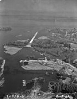
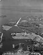
The Governor Albert D. Rosellini Bridge—Evergreen Point (formerly the Evergreen Point Floating Bridge, and commonly called the SR 520 Bridge or 520 Bridge) is the longest floating bridge
on Earth at 2285 metres (7,496.7 ft) and carries State Route 520 across Lake Washington
from Seattle
to Medina
.
The Evergreen Point
of the bridge's original name is the westernmost of the three small Eastside
peninsulas that SR-520 crosses. (The other two are Hunts Point
and Yarrow Point
.) In 1988, it was renamed for Rosellini, who had advocated its construction.
 The bridge was opened for commuter traffic on August 28, 1963, after three years of construction. It was built as a four-lane toll bridge
to provide easy access from Seattle to Eastside
communities such as Bellevue
, Kirkland
, and Redmond
. The total cost of the bridge, in 1961 dollars, was $21 million ($153 million in 2011 dollars). To make up for this cost, commuters paid a 35-cent toll in each direction until 1979. The toll booths were then converted into bus stops.
The bridge impacted many communities on the Eastside. Redmond's population saw a dramatic increase, jumping from less than 1,500 in 1960 to 11,000 in 1970. It was the second floating bridge to cross Lake Washington; the first was the Lake Washington Floating Bridge
, built in 1940 as part of U.S. Route 10, later part of Interstate 90, which at its construction was the largest floating structure ever built.
In 1989, an electrical fault caused the drawspan to open during rush hour, causing one death and five injuries. In 2000, a gravel barge
struck the bridge, closing it for eleven days and causing $500,000 worth of damage.
 Today the bridge is near the end of its useful life, according to the state Department of Transportation
. In 1997, Myint Lwin, WSDOT's chief bridge engineer at that time, said that even with repairs, the bridge could be expected to last only about twenty more years (until 2017). The bridge must be closed in high winds, and even after a seismic retrofit in 1999, it is at risk of collapse in an earthquake. Because of the weight of various reinforcements over the years, the bridge currently rides about 1 feet (30.5 cm) lower in the water than it did originally. The DOT is working on replacing the aging bridge with a new span of six lanes.
The bridge is anchored by a large number of high-strength cables. According to an interview conducted by local newspapers, a severe storm during the bridge's lifespan came within strands of breaking some of these cables, which would have resulted in the catastrophic collapse of the bridge. Since then, additional cables have been added, and much of the bridge has been replaced with lighter materials, but the danger remains. The bridge was originally designed to stand up to a 100-year storm, but the assumptions used actually reflected what is now considered to be a 20-year storm for the Seattle area.
Just five years after the bridge opened, a study commissioned by the state legislature was completed to figure out how to provide for the great demand for cross-lake transportation. That study evaluated bridge and tunnel crossings north and south of the bridge. To help provide the political lubrication needed for any plan to go forward, the Trans-Lake Study was commissioned by the State of Washington. The study brought together 47 representatives of public agencies, neighborhoods, businesses, and advocacy interests. Ten years later, the problems have not been solved. WSDOT is proceeding with plans to build the bridge replacement, with an opening in 2014. To fund these improvements, in May 2009, Gov. Gregoire signed ESHB 2211, which authorizes tolling on the SR 520 bridge beginning in 2010. The intent of tolling the SR 520 bridge is to allow WSDOT to secure revenue in order to begin pontoon construction in 2010, which is critical to replacing the SR 520 bridge by 2014. Tolling is expected to start in summer 2011. The State Transportation Commission has proposed a toll of US$3.50 each way during peak periods. The proposed rates during other hours are to range from $0 to $2.80. Many groups continue to fight the project, even as it steadily moves toward construction.
passes will be done by license plates. Toll readers will be placed on gantries at the east highrise.
 The bridge carries 115,000 vehicles per day but was only designed to carry 65,000. Because of this bottleneck, commuters often follow the motto "anything but the 520 bridge" during peak traffic, with I-90 or even a northbound loop around the lake via Bothell
and Kenmore
preferred as alternate routes.
Because Microsoft
, one of the area's largest employers, is on the Eastside just off 520, traffic on the bridge tends to be heaviest west-to-east (away from Seattle) in the morning and east-to-west (toward Seattle) in the evening, opposite from what one might expect, a so-called "reverse commute". (The I-90 floating bridge has more typical traffic patterns, with commuters going into Seattle in the morning and returning east in the evening.) Commuters often use this knowledge to take the bridge with the least traffic for their desired trip at various times of day. Electronic signs on I-405 display estimated times to Seattle for both 520 and I-90 routes. Commuters jest about the traffic bottleneck that is created around the 520 bridge and Interstate 405, nicknaming it "The Kirkland Crawl" as it becomes parking lot traffic during peak rush hour, around the city of Kirkland where 520 (coming from Redmond and Microsoft) and 405 (south from Everett and Boeing) meet.
Scenery visible westbound on clear days include the Olympic Mountains
and Husky Stadium
on the University of Washington
campus, as well as two metal sculptures. Eastbound are expensive waterfront homes in Medina
, including the large home
of Bill Gates
on the southern side, which is extensively lit during the holiday season.
On clear days, Mount Baker
is visible to the north, the Cascade Mountains are the backdrop, and Mount Rainier
is to the southeast. Mercer Island is to the south. On July 4
, fireworks are visible from many communities and homes along the lake.
The bridge incorporates an infrequently used drawspan
to allow large vessels to pass. Smaller vessels pass under the "high rises", elevated portions of the bridge on each end. The drawspan is also opened during major storms to relieve water pressure.
Pontoon bridge
A pontoon bridge or floating bridge is a bridge that floats on water and in which barge- or boat-like pontoons support the bridge deck and its dynamic loads. While pontoon bridges are usually temporary structures, some are used for long periods of time...
on Earth at 2285 metres (7,496.7 ft) and carries State Route 520 across Lake Washington
Lake Washington
Lake Washington is a large freshwater lake adjacent to the city of Seattle. It is the largest lake in King County and the second largest in the state of Washington, after Lake Chelan. It is bordered by the cities of Seattle on the west, Bellevue and Kirkland on the east, Renton on the south and...
from Seattle
Seattle, Washington
Seattle is the county seat of King County, Washington. With 608,660 residents as of the 2010 Census, Seattle is the largest city in the Northwestern United States. The Seattle metropolitan area of about 3.4 million inhabitants is the 15th largest metropolitan area in the country...
to Medina
Medina, Washington
Medina is a city located in the Eastside, a region of King County, Washington, United States. Surrounded on the north, west, and south by Lake Washington, opposite Seattle, Medina is bordered by Clyde Hill and Hunts Point, as well as the satellite city of Bellevue. The city's population was 2,969...
.
The Evergreen Point
Evergreen Point
Evergreen Point is the westernmost of a group of three small peninsulas on the east side of Lake Washington, King County, Washington. It is situated between the main body of the lake and Fairweather Bay. Most notable for being the namesake of the Evergreen Point Floating Bridge, it is part of the...
of the bridge's original name is the westernmost of the three small Eastside
Eastside (King County, Washington)
File:Seattle-lakewashington-lakesammamish.PNG|250px|right|The Eastside is to the right of Seattle.# rough city boundariespoly 137 256 148 256 158 194 172 179 172 237 212 266 133 266Renton...
peninsulas that SR-520 crosses. (The other two are Hunts Point
Hunts Point, Washington
Hunts Point is a town located in the Eastside, a region of King County, Washington, United States, and part of the Seattle metropolitan area. The town is located on a small peninsula surrounded by Lake Washington, and is near the suburbs of Medina , Clyde Hill , Yarrow Point , and Kirkland , as...
and Yarrow Point
Yarrow Point, Washington
Yarrow Point is a town in King County, Washington, United States. The population was 1,001 at the 2010 census.Based on per capita income, one of the more reliable measures of affluence, Yarrow Point ranks fifth of 522 areas in the state of Washington to be ranked.-Geography:Yarrow Point is located...
.) In 1988, it was renamed for Rosellini, who had advocated its construction.
History
Toll bridge
A toll bridge is a bridge over which traffic may pass upon payment of a toll, or fee.- History :The practice of collecting tolls on bridges probably harks back to the days of ferry crossings where people paid a fee to be ferried across stretches of water. As boats became impractical to carry large...
to provide easy access from Seattle to Eastside
Eastside (King County, Washington)
File:Seattle-lakewashington-lakesammamish.PNG|250px|right|The Eastside is to the right of Seattle.# rough city boundariespoly 137 256 148 256 158 194 172 179 172 237 212 266 133 266Renton...
communities such as Bellevue
Bellevue, Washington
Bellevue is a city in the Eastside region of King County, Washington, United States, across Lake Washington from Seattle. Long known as a suburb or satellite city of Seattle, it is now categorized as an edge city or a boomburb. The population was 122,363 at the 2010 census.Downtown Bellevue is...
, Kirkland
Kirkland, Washington
Kirkland is a city in King County, Washington, United States. It is a suburb of Seattle on the Eastside . The population was 48,787 at the 2010 census makes it the 9th largest city in King County and the 20th largest city in the state...
, and Redmond
Redmond, Washington
Redmond is a city in King County, Washington, United States, located east of Seattle. The population was 54,144 at the 2010 census,up from 45,256 in 2000....
. The total cost of the bridge, in 1961 dollars, was $21 million ($153 million in 2011 dollars). To make up for this cost, commuters paid a 35-cent toll in each direction until 1979. The toll booths were then converted into bus stops.
The bridge impacted many communities on the Eastside. Redmond's population saw a dramatic increase, jumping from less than 1,500 in 1960 to 11,000 in 1970. It was the second floating bridge to cross Lake Washington; the first was the Lake Washington Floating Bridge
Lacey V. Murrow Memorial Bridge
The Lacey V. Murrow Memorial Bridge is a floating bridge that carries the eastbound lanes of Interstate 90 across Lake Washington from Seattle to Mercer Island, Washington. It is the second longest floating bridge on Earth at , whereas the longest is the Evergreen Point Floating Bridge just a few...
, built in 1940 as part of U.S. Route 10, later part of Interstate 90, which at its construction was the largest floating structure ever built.
In 1989, an electrical fault caused the drawspan to open during rush hour, causing one death and five injuries. In 2000, a gravel barge
Barge
A barge is a flat-bottomed boat, built mainly for river and canal transport of heavy goods. Some barges are not self-propelled and need to be towed by tugboats or pushed by towboats...
struck the bridge, closing it for eleven days and causing $500,000 worth of damage.
Future replacement
Washington State Department of Transportation
The Washington State Department of Transportation , was established in 1905. The agency, led by a Secretary and overseen by the Governor, is a Washington governmental agency that constructs, maintains, and regulates the use of the state's transportation infrastructure...
. In 1997, Myint Lwin, WSDOT's chief bridge engineer at that time, said that even with repairs, the bridge could be expected to last only about twenty more years (until 2017). The bridge must be closed in high winds, and even after a seismic retrofit in 1999, it is at risk of collapse in an earthquake. Because of the weight of various reinforcements over the years, the bridge currently rides about 1 feet (30.5 cm) lower in the water than it did originally. The DOT is working on replacing the aging bridge with a new span of six lanes.
The bridge is anchored by a large number of high-strength cables. According to an interview conducted by local newspapers, a severe storm during the bridge's lifespan came within strands of breaking some of these cables, which would have resulted in the catastrophic collapse of the bridge. Since then, additional cables have been added, and much of the bridge has been replaced with lighter materials, but the danger remains. The bridge was originally designed to stand up to a 100-year storm, but the assumptions used actually reflected what is now considered to be a 20-year storm for the Seattle area.
Just five years after the bridge opened, a study commissioned by the state legislature was completed to figure out how to provide for the great demand for cross-lake transportation. That study evaluated bridge and tunnel crossings north and south of the bridge. To help provide the political lubrication needed for any plan to go forward, the Trans-Lake Study was commissioned by the State of Washington. The study brought together 47 representatives of public agencies, neighborhoods, businesses, and advocacy interests. Ten years later, the problems have not been solved. WSDOT is proceeding with plans to build the bridge replacement, with an opening in 2014. To fund these improvements, in May 2009, Gov. Gregoire signed ESHB 2211, which authorizes tolling on the SR 520 bridge beginning in 2010. The intent of tolling the SR 520 bridge is to allow WSDOT to secure revenue in order to begin pontoon construction in 2010, which is critical to replacing the SR 520 bridge by 2014. Tolling is expected to start in summer 2011. The State Transportation Commission has proposed a toll of US$3.50 each way during peak periods. The proposed rates during other hours are to range from $0 to $2.80. Many groups continue to fight the project, even as it steadily moves toward construction.
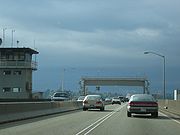
Tolling
In December 2011, tolling will start on the SR 520 floating bridge. The revenue generated from the tolls will help pay for the replacement bridge. All tolling will be done automatically with no tollbooths. Tolling for people without Good To Go!Good To Go!
Good To Go! is the electronic toll collection system used by the Washington State Department of Transportation on all current and future toll projects in the state of Washington. Good To Go! customers prepay their tolls into an account, the tolls are then electronically deducted as the customer...
passes will be done by license plates. Toll readers will be placed on gantries at the east highrise.
Toll Schedule
Toll rates for two-axle vehicles (includes motorcycles). Multi-axle vehicles will pay a higher rate.| Day | Time | Rate: Good to Go | Rate: License plate tolling |
|---|---|---|---|
| Monday-Friday | Midnight to 5 a.m. | $0.00 | $0.00 |
| 5 a.m. to 6 a.m. | $1.60 | $3.10 | |
| 6 a.m. to 7 a.m. | $2.80 | $4.30 | |
| 7 a.m. to 9 a.m. | $3.50 | $5.00 | |
| 9 a.m. to 10 a.m. | $2.80 | $4.30 | |
| 10 a.m. to 2 p.m. | $2.25 | $3.75 | |
| 2 p.m. to 3 p.m. | $2.80 | $4.30 | |
| 3 p.m. to 6 p.m. | $3.50 | $5.00 | |
| 6 p.m. to 7 p.m. | $2.80 | $4.30 | |
| 7 p.m. to 9 p.m. | $2.25 | $3.75 | |
| 9 p.m. to 11 p.m. | $1.60 | $3.10 | |
| 11 p.m. to 11:59 p.m. | $0.00 | $0.00 | |
| Saturdays and Sundays | Midnight to 5 a.m. | $0.00 | $0.00 |
| 5 a.m. to 8 a.m. | $1.10 | $2.60 | |
| 8 a.m. to 11 a.m. | $1.65 | $3.15 | |
| 11 a.m. to 6 p.m. | $2.20 | $3.70 | |
| 6 p.m. to 9 p.m. | $1.65 | $3.15 | |
| 9 p.m. to 11 p.m. | $1.10 | $2.60 | |
| 11 p.m. to 11:59 p.m. | $0.00 | $0.00 |
Usage
Bothell, Washington
Bothell is a city located in King and Snohomish Counties in the state of Washington. It is part of the Seattle metropolitan area. The population was 33,505 as of the 2010 census...
and Kenmore
Kenmore, Washington
Kenmore is a city in King County, Washington, United States, along the northernmost shores of Lake Washington...
preferred as alternate routes.
Because Microsoft
Microsoft
Microsoft Corporation is an American public multinational corporation headquartered in Redmond, Washington, USA that develops, manufactures, licenses, and supports a wide range of products and services predominantly related to computing through its various product divisions...
, one of the area's largest employers, is on the Eastside just off 520, traffic on the bridge tends to be heaviest west-to-east (away from Seattle) in the morning and east-to-west (toward Seattle) in the evening, opposite from what one might expect, a so-called "reverse commute". (The I-90 floating bridge has more typical traffic patterns, with commuters going into Seattle in the morning and returning east in the evening.) Commuters often use this knowledge to take the bridge with the least traffic for their desired trip at various times of day. Electronic signs on I-405 display estimated times to Seattle for both 520 and I-90 routes. Commuters jest about the traffic bottleneck that is created around the 520 bridge and Interstate 405, nicknaming it "The Kirkland Crawl" as it becomes parking lot traffic during peak rush hour, around the city of Kirkland where 520 (coming from Redmond and Microsoft) and 405 (south from Everett and Boeing) meet.
Scenery visible westbound on clear days include the Olympic Mountains
Olympic Mountains
The Olympic Mountains is a mountain range on the Olympic Peninsula of western Washington in the United States. The mountains, part of the Pacific Coast Ranges, are not especially high - Mount Olympus is the highest at - but the western slopes of the Olympics rise directly out of the Pacific...
and Husky Stadium
Husky Stadium
Husky Stadium is an outdoor athletic stadium on the campus of the University of Washington in Seattle, Washington, United States. It is the home of the Washington Huskies...
on the University of Washington
University of Washington
University of Washington is a public research university, founded in 1861 in Seattle, Washington, United States. The UW is the largest university in the Northwest and the oldest public university on the West Coast. The university has three campuses, with its largest campus in the University...
campus, as well as two metal sculptures. Eastbound are expensive waterfront homes in Medina
Medina, Washington
Medina is a city located in the Eastside, a region of King County, Washington, United States. Surrounded on the north, west, and south by Lake Washington, opposite Seattle, Medina is bordered by Clyde Hill and Hunts Point, as well as the satellite city of Bellevue. The city's population was 2,969...
, including the large home
Bill Gates' house
Bill Gates' house is a large mansion in the side of a hill overlooking Lake Washington in Medina, Washington. The house is noted for its design and the technology it incorporates...
of Bill Gates
Bill Gates
William Henry "Bill" Gates III is an American business magnate, investor, philanthropist, and author. Gates is the former CEO and current chairman of Microsoft, the software company he founded with Paul Allen...
on the southern side, which is extensively lit during the holiday season.
On clear days, Mount Baker
Mount Baker
Mount Baker , also known as Koma Kulshan or simply Kulshan, is an active glaciated andesitic stratovolcano in the Cascade Volcanic Arc and the North Cascades of Washington State in the United States. It is the second-most active volcano in the range after Mount Saint Helens...
is visible to the north, the Cascade Mountains are the backdrop, and Mount Rainier
Mount Rainier
Mount Rainier is a massive stratovolcano located southeast of Seattle in the state of Washington, United States. It is the most topographically prominent mountain in the contiguous United States and the Cascade Volcanic Arc, with a summit elevation of . Mt. Rainier is considered one of the most...
is to the southeast. Mercer Island is to the south. On July 4
Independence Day (United States)
Independence Day, commonly known as the Fourth of July, is a federal holiday in the United States commemorating the adoption of the Declaration of Independence on July 4, 1776, declaring independence from the Kingdom of Great Britain...
, fireworks are visible from many communities and homes along the lake.
The bridge incorporates an infrequently used drawspan
Retractable bridge
A retractable bridge is a type of movable bridge in which the deck can be rolled or slid backwards to open a gap for crossing traffic, usually a ship on a waterway. This type is sometimes referred to as a thrust bridge....
to allow large vessels to pass. Smaller vessels pass under the "high rises", elevated portions of the bridge on each end. The drawspan is also opened during major storms to relieve water pressure.