
Eurobodalla Shire
Encyclopedia
New South Wales
New South Wales is a state of :Australia, located in the east of the country. It is bordered by Queensland, Victoria and South Australia to the north, south and west respectively. To the east, the state is bordered by the Tasman Sea, which forms part of the Pacific Ocean. New South Wales...
, Australia
Australia
Australia , officially the Commonwealth of Australia, is a country in the Southern Hemisphere comprising the mainland of the Australian continent, the island of Tasmania, and numerous smaller islands in the Indian and Pacific Oceans. It is the world's sixth-largest country by total area...
. It is located in a largely mountainous coastal region on the South Coast of New South Wales. It is on the Pacific Ocean
Pacific Ocean
The Pacific Ocean is the largest of the Earth's oceanic divisions. It extends from the Arctic in the north to the Southern Ocean in the south, bounded by Asia and Australia in the west, and the Americas in the east.At 165.2 million square kilometres in area, this largest division of the World...
, the Princes Highway
Princes Highway
The Princes Highway extends from Sydney to Port Augusta via the coast through the states of New South Wales, Victoria and South Australia, a distance of 1941 km or 1898 km via the former alignments of the highway ....
and the Kings Highway
Kings Highway, Australia
The Kings Highway connects Canberra and Batemans Bay. It starts at the junction with the Monaro Highway on Canberra Avenue in the Australian Capital Territory crossing over the border into New South Wales near Queanbeyan, passing through Queanbeyan itself, briefly crossing back into the Kowen...
.
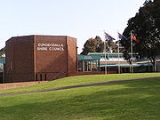
The shire chambers are located in the town of Moruya
Moruya, New South Wales
Moruya is a small regional centre in New South Wales, Australia, situated on the Moruya River, approximately 300 kilometers south of Sydney. At the 2006 census, Moruya had a population of 10,278 people. The town relies predominantly on agriculture, aquaculture, and tourism...
in the central part of the Shire. Other major towns within the shire include Batemans Bay
Batemans Bay, New South Wales
- Media :Radio Stations*East Coast Radio 2EC *Power FM NSW South Coast - POWER FM from Nowra can also be received in parts of Batemans Bay on FM 94.9....
and Narooma
Narooma, New South Wales
Narooma is a town in the Australian state of New South Wales on the far south coast. The town is on the Princes Highway. The name is said to be derived from the Aboriginal word meaning ‘clear blue waters’. At the 2006 census, Narooma had a population of 3,100 people.Montague Island, a National...
. Smaller towns and hamlets include Durras
South Durras, New South Wales
South Durras is a small village on the South Coast of New South Wales, Australia. South Durras is located approximately 280 kilometres south of Sydney and 15 kilometres north of Batemans Bay, in the local government area of Eurobodalla Shire...
, Nelligen
Nelligen, New South Wales
Nelligen is a village on the Clyde River on the South Coast of New South Wales, Australia. It is located on the Kings Highway.-Location and services :The village is situated on the western bank of the River near a junction with Nelligen Creek,...
, Mogo
Mogo, New South Wales
Mogo is a small town in the South Coast region of the state of New South Wales, Australia. Mogo is administered by the Eurobodalla Shire council. The town is located on the Princes Highway , south of Batemans Bay and north of Moruya...
, Malua Bay
Malua Bay, New South Wales
Malua Bay is a locality in the South Coast region of the state of New South Wales, Australia. It is situated in the Eurobodalla Shire. At the 2006 census, Malua Bay had a population of 1,907 people....
, Broulee
Broulee, New South Wales
Broulee is a town on the south coast of New South Wales between Batemans Bay and Moruya. In 2006, the town had a population of 1,292 people. Just off the beach is a Broulee Island, currently joined to the mainland, but in past years the connecting spit has been covered by water, at times a very ...
, Mossy Point, Rosedale
Rosedale, New South Wales
Rosedale is a beachside settlement in New South Wales, Australia. It is south of Batemans Bay on the south coast. The area is administered by the Eurobodalla Shire. At the 2006 census, Rosedale had a population of 127 people.- History :...
, Bodalla
Bodalla, New South Wales
Bodalla is a small town on the South Coast of New South Wales, Australia, and located in the local government area of Eurobodalla Shire. The town sits on the Princes Highway, and is connected by road to Moruya, Narooma, Nerrigundah, Eurobodalla and Potato Point.The Yuin people are consider to be...
, Potato Point
Potato Point, New South Wales
Potato Point is a village in the Eurobodalla Shire lying on the south coast of New South Wales, Australia. It is connected by road to the town of Bodalla, and surrounded by the Eurobodalla National Park. The Yuin are considered to be the traditional owners of the region. At the 2006 census, Potato...
, Nerrigundah
Nerrigundah, New South Wales
thumb|right|220px|Nerrigundah & memorial obeliskNerrigundah is a small village on the Eurobodalla Nature Coast in south eastern New South Wales. Situated at the head of the Tuross River Valley, it is nineteen kilometres inland from Bodalla. At the 2006 census, Nerrigundah had a population of 100...
, Mystery Bay
Mystery Bay, New South Wales
Mystery Bay is a small town on the south coast of New South Wales, Australia. Mystery Bay is located halfway between Central Tilba and Narooma, two kilometers off the Princes Highway on Mystery Bay Road. At the 2006 census, Mystery Bay had a population of 168 people. Mystery Bay features a camping...
, Central Tilba, and Wallaga Lake Koori Village.
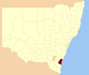
The Eurobodalla Shire Council was formed in 1913 with the responsibility for administering local government functions along 110 kilometres of the NSW coast between Durras and Wallaga Lake. The Council administers only about 30% of the area of the Shire as the remaining 70% is non-rateable crown land
Crown land
In Commonwealth realms, Crown land is an area belonging to the monarch , the equivalent of an entailed estate that passed with the monarchy and could not be alienated from it....
held as national park and state forest: 40% of the shire is national park, 30% is state forest, 20% is productive farmland and 10% is urban settlement.
The Shire is unusual in that nearly half of ratepayers are non-residents. Just over 17% of ratepayers are residents of Canberra
Canberra
Canberra is the capital city of Australia. With a population of over 345,000, it is Australia's largest inland city and the eighth-largest city overall. The city is located at the northern end of the Australian Capital Territory , south-west of Sydney, and north-east of Melbourne...
. Although the permanent population is around 34,100, the visiting population (who stay more than 3 nights) is 3.1 million per year.
The main growth industries in the area are Construction, Government Services, Real Estate, Retail, Retirement, Aged Care, Tourism, while dairy farming, forestry, sawmilling and commercial fishing are traditional industries in decline. Eurobodalla Shire is serviced by two highways - the Princes Highway
Princes Highway
The Princes Highway extends from Sydney to Port Augusta via the coast through the states of New South Wales, Victoria and South Australia, a distance of 1941 km or 1898 km via the former alignments of the highway ....
between Sydney
Sydney
Sydney is the most populous city in Australia and the state capital of New South Wales. Sydney is located on Australia's south-east coast of the Tasman Sea. As of June 2010, the greater metropolitan area had an approximate population of 4.6 million people...
and Melbourne
Melbourne
Melbourne is the capital and most populous city in the state of Victoria, and the second most populous city in Australia. The Melbourne City Centre is the hub of the greater metropolitan area and the Census statistical division—of which "Melbourne" is the common name. As of June 2009, the greater...
(part of the renowned Highway One
Highway 1 (Australia)
Australia's Highway 1 is a network of highways that circumnavigate the Australian continent, joining all mainland state capitals. At a total length of approximately it is the longest national highway in the world, longer than the Trans-Siberian Highway and the Trans-Canada Highway...
around Australia), and the Kings Highway
Kings Highway, Australia
The Kings Highway connects Canberra and Batemans Bay. It starts at the junction with the Monaro Highway on Canberra Avenue in the Australian Capital Territory crossing over the border into New South Wales near Queanbeyan, passing through Queanbeyan itself, briefly crossing back into the Kowen...
(National Route 52) linking Batemans Bay to Canberra
Canberra
Canberra is the capital city of Australia. With a population of over 345,000, it is Australia's largest inland city and the eighth-largest city overall. The city is located at the northern end of the Australian Capital Territory , south-west of Sydney, and north-east of Melbourne...
, the national capital. Moruya Airport
Moruya Airport
Moruya Airport is an airport located Moruya, New South Wales, Australia.-History:Built in 1942, at Moruya Heads by the RAAF consisting of three runways...
, just east of the township of Moruya, is serviced by regular scheduled commuter flights to Sydney and Melbourne. There are no railways or major seaports in Eurobodalla Shire.
The Eurobodalla Shire was originally the home of the South Coast Bugelli-Manji and Yuin
Yuin
Yuin people are those Australian Aborigines from the South Coast of New South wales who are considered to be the traditional owners of the land and water from Merimbula to Port Jackson.- Country :...
Aboriginal peoples. The Council signed a Commitment to Indigenous Australians and a Local Agreement with the Aboriginal Community.
Council
Eurobodalla Shire Council is composed of eight councillors elected proportionally, in addition to the mayor, who is elected directly. The current makeup of the council, including the mayor, is as follows:| Party | Councillors | |
|---|---|---|
| Independents Independent (politician) In politics, an independent or non-party politician is an individual not affiliated to any political party. Independents may hold a centrist viewpoint between those of major political parties, a viewpoint more extreme than any major party, or they may have a viewpoint based on issues that they do... |
5 | |
| Eurobodalla First | 3 | |
| Shire Wide Action Group | 1 | |
| Total | 9 | |
The current council, elected in 2008, is:
| Councillor | Party | Notes | |
|---|---|---|---|
| Fergus Thomson | Independent Independent (politician) In politics, an independent or non-party politician is an individual not affiliated to any political party. Independents may hold a centrist viewpoint between those of major political parties, a viewpoint more extreme than any major party, or they may have a viewpoint based on issues that they do... |
Mayor | |
| Rob Pollock | Eurobodalla First | ||
| Alan Morton | Independent Independent (politician) In politics, an independent or non-party politician is an individual not affiliated to any political party. Independents may hold a centrist viewpoint between those of major political parties, a viewpoint more extreme than any major party, or they may have a viewpoint based on issues that they do... |
||
| Keith Dance | Independent Independent (politician) In politics, an independent or non-party politician is an individual not affiliated to any political party. Independents may hold a centrist viewpoint between those of major political parties, a viewpoint more extreme than any major party, or they may have a viewpoint based on issues that they do... |
||
| Lindsay Brown | Eurobodalla First | ||
| Allan Brown | Shire Wide Action | ||
| Chris Vardon | Eurobodalla First | Deputy Mayor | |
| Chris Kowal | Independent Independent (politician) In politics, an independent or non-party politician is an individual not affiliated to any political party. Independents may hold a centrist viewpoint between those of major political parties, a viewpoint more extreme than any major party, or they may have a viewpoint based on issues that they do... |
||
| Graham Scobie | Independent Independent (politician) In politics, an independent or non-party politician is an individual not affiliated to any political party. Independents may hold a centrist viewpoint between those of major political parties, a viewpoint more extreme than any major party, or they may have a viewpoint based on issues that they do... |
||
Census 2001 statistics
Population: 33,167Area: 3,422 square kilometres
Population density: 9.8 people per square kilometre
Aged 15 years and over: 80.7%
A significant proportion of young people leave the shire to continue their studies or seek work.
Aged 65 years and over: 22.2%
The proportion of older residents is growing as retirees move into the shire.
Median age: 44
Aboriginal or Torres Strait Islander: 4.2%
Nation of birth:
Australia
Australia
Australia , officially the Commonwealth of Australia, is a country in the Southern Hemisphere comprising the mainland of the Australian continent, the island of Tasmania, and numerous smaller islands in the Indian and Pacific Oceans. It is the world's sixth-largest country by total area...
- 86.0%
United Kingdom
United Kingdom
The United Kingdom of Great Britain and Northern IrelandIn the United Kingdom and Dependencies, other languages have been officially recognised as legitimate autochthonous languages under the European Charter for Regional or Minority Languages...
- 6.8%
New Zealand
New Zealand
New Zealand is an island country in the south-western Pacific Ocean comprising two main landmasses and numerous smaller islands. The country is situated some east of Australia across the Tasman Sea, and roughly south of the Pacific island nations of New Caledonia, Fiji, and Tonga...
- 1.2%
Germany
Germany
Germany , officially the Federal Republic of Germany , is a federal parliamentary republic in Europe. The country consists of 16 states while the capital and largest city is Berlin. Germany covers an area of 357,021 km2 and has a largely temperate seasonal climate...
- 1.0%
Netherlands
Netherlands
The Netherlands is a constituent country of the Kingdom of the Netherlands, located mainly in North-West Europe and with several islands in the Caribbean. Mainland Netherlands borders the North Sea to the north and west, Belgium to the south, and Germany to the east, and shares maritime borders...
- 0.7%
Switzerland
Switzerland
Switzerland name of one of the Swiss cantons. ; ; ; or ), in its full name the Swiss Confederation , is a federal republic consisting of 26 cantons, with Bern as the seat of the federal authorities. The country is situated in Western Europe,Or Central Europe depending on the definition....
- 0.5%
Median weekly rent: $100-$149
Median monthly home loan repayments: $600-$799
Median weekly individual income: $200-$299
Median weekly household income: $400-$499
Mean household size: 2.3
Unemployment rate: 13.0%
Labour force participation rate: 46.7%
In 2004, the Shire had 10,338 jobs.
Languages spoken at home:
Speaks English only - 96.1%
German - 0.7%
Italian - 0.4%
Croatian - 0.4%
Netherlandic - 0.3%
Religion:
Anglican Church - 31.3%
Roman Catholic Church
Roman Catholic Church
The Catholic Church, also known as the Roman Catholic Church, is the world's largest Christian church, with over a billion members. Led by the Pope, it defines its mission as spreading the gospel of Jesus Christ, administering the sacraments and exercising charity...
- 25.2%
Uniting Church in Australia
Uniting Church in Australia
The Uniting Church in Australia was formed on 22 June 1977 when many congregations of the Methodist Church of Australasia, the Presbyterian Church of Australia and the Congregational Union of Australia came together under the Basis of Union....
- 6.0%
Presbyterian and Reformed Churches - 4.7%
Other Christian denominations - 6.4%
Non-Christian religions - 1.2%
No religion - 15.5%
Did not answer question - 9.7%
Household car ownership:
No car - 8.8%
One car - 53.3%
Two cars - 29.9%
Three or more cars - 8.0%
Housing tenure:
Fully owned - 54.5%
Being purchased - 18.5%
Department of Housing (public housing) - 2.4%
Private rental - 21.0%
Other type of tenure - 3.7%
Structure of inhabited dwellings:
Fully detached house - 82.0%
Semi-detached, terrace or town house - 6.9%
Apartment - 5.8%
Caravan, cabin, houseboat, etc. - 3.7%
Other - 1.5%
Housing stock vacancy rate: 29.5%
Internet usage rate: 27.3%