
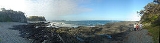
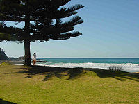
Malua Bay, New South Wales
Encyclopedia
South Coast, New South Wales
The South Coast refers to the narrow coastal belt from Sydney in the north to the border with Victoria in the south in the south-eastern part of the State of New South Wales, Australia. It is bordered to the west by the coastal escarpment of the Southern Tablelands, which is largely covered by a...
of the state of New South Wales
New South Wales
New South Wales is a state of :Australia, located in the east of the country. It is bordered by Queensland, Victoria and South Australia to the north, south and west respectively. To the east, the state is bordered by the Tasman Sea, which forms part of the Pacific Ocean. New South Wales...
, Australia
Australia
Australia , officially the Commonwealth of Australia, is a country in the Southern Hemisphere comprising the mainland of the Australian continent, the island of Tasmania, and numerous smaller islands in the Indian and Pacific Oceans. It is the world's sixth-largest country by total area...
. It is situated in the Eurobodalla Shire
Eurobodalla Shire
Eurobodalla Shire is a Local Government Area in the state of New South Wales, Australia. It is located in a largely mountainous coastal region on the South Coast of New South Wales. It is on the Pacific Ocean, the Princes Highway and the Kings Highway....
. At the 2006 census
Census in Australia
The Australian census is administered once every five years by the Australian Bureau of Statistics. The most recent census was conducted on 9 August 2011; the next will be conducted in 2016. Prior to the introduction of regular censuses in 1961, they had also been run in 1901, 1911, 1921, 1933,...
, Malua Bay had a population of 1,907 people.
Malua Bay is located on George Bass Drive, about 15 minutes’ drive from the town of Batemans Bay
Batemans Bay, New South Wales
- Media :Radio Stations*East Coast Radio 2EC *Power FM NSW South Coast - POWER FM from Nowra can also be received in parts of Batemans Bay on FM 94.9....
. It is about 280 km (174 mi) south of Sydney
Sydney
Sydney is the most populous city in Australia and the state capital of New South Wales. Sydney is located on Australia's south-east coast of the Tasman Sea. As of June 2010, the greater metropolitan area had an approximate population of 4.6 million people...
, and 160 km east of Canberra
Canberra
Canberra is the capital city of Australia. With a population of over 345,000, it is Australia's largest inland city and the eighth-largest city overall. The city is located at the northern end of the Australian Capital Territory , south-west of Sydney, and north-east of Melbourne...
via the Kings Highway
Kings Highway, Australia
The Kings Highway connects Canberra and Batemans Bay. It starts at the junction with the Monaro Highway on Canberra Avenue in the Australian Capital Territory crossing over the border into New South Wales near Queanbeyan, passing through Queanbeyan itself, briefly crossing back into the Kowen...
.
Facilities
- Malua Bay website
- Batemans Bay Surf Life Saving Club
- Malua Bay Bowling & Recreation Club
- LJ Hooker Malua Bay