

Broulee, New South Wales
Encyclopedia
New South Wales
New South Wales is a state of :Australia, located in the east of the country. It is bordered by Queensland, Victoria and South Australia to the north, south and west respectively. To the east, the state is bordered by the Tasman Sea, which forms part of the Pacific Ocean. New South Wales...
between Batemans Bay
Batemans Bay, New South Wales
- Media :Radio Stations*East Coast Radio 2EC *Power FM NSW South Coast - POWER FM from Nowra can also be received in parts of Batemans Bay on FM 94.9....
and Moruya
Moruya, New South Wales
Moruya is a small regional centre in New South Wales, Australia, situated on the Moruya River, approximately 300 kilometers south of Sydney. At the 2006 census, Moruya had a population of 10,278 people. The town relies predominantly on agriculture, aquaculture, and tourism...
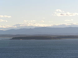
. In 2006, the town had a population of 1,292 people. Just off the beach is a Broulee Island
Broulee Island Nature Reserve
The Broulee Island Nature Reserve is a 43–hectare reserve on the south coast of New South Wales, Australia. The reserve was created in 1972 and is managed by the New South Wales Department of Environment and Climate Change. The reserve is adjacent to the village of Broulee.- External links :*...
, currently joined to the mainland, but in past years the connecting spit has been covered by water, at times a very deep navigable channel with a strong current.
The first harbour in the area south of Batemans Bay was established at Broulee behind what is now known as the island. Although settlement had already commenced on the shores of the nearby Moruya River
Moruya River
The Moruya River is in southern New South Wales, Australia. Its freshwater reaches are known as the Deua River.The headwaters of the Moruya River rise as the Deua River south of Braidwood...
, it was not easily navigable due to a sandbar at its mouth.
The Broulee area was surveyed and gazetted in 1837 and land sales commenced in 1840. At that time a post office was opened with mail being delivered each week over the mountains from Braidwood
Braidwood, New South Wales
Braidwood is a town in the Southern Tablelands of New South Wales, Australia, in Palerang Shire. It is located on the busy Kings Highway linking Canberra to Batemans Bay on the coast. It is about 200 kilometres south west of Sydney and about 60 kilometres inland from the coast...
. Henry Clarke
Henry Clarke (Australian politician)
Henry Clarke was an Australian businessman and politician in the New South Wales Legislative Assembly.Clarke was born in Maghera, County Londonderry, Ireland, he emigrated to New South Wales in 1841 and he farmed for a while at Broulee. He returned to Sydney and married Jane Rayner in 1847 and...
took up farming in the Broulee area in the 1840s after emigrating from Ireland. The first court in the district was established also in 1840 and in 1841 Broulee was made the centre of a police district which covered the area from Jervis Bay
Jervis Bay Territory
The Jervis Bay Territory is a territory of the Commonwealth of Australia. It was surrendered by the state of New South Wales to the Commonwealth Government in 1915 so that the Federal capital at Canberra would have "access to the sea"....
to Eden, New South Wales
Eden, New South Wales
Eden is a coastal town in the South Coast region of New South Wales, Australia. The town, south of the state capital Sydney near the border with Victoria, is located between Nullica Bay to the south and Calle Calle Bay, the northern reach of Twofold Bay, and built on undulating land adjacent to a...
.
In 1841 a flood washed away the sandbar at the mouth of the Moruya River. Land up the river was for sale from 1848 and the Moruya town site surveyed in 1850 and the town gazetted in 1851. That year gold was discovered at Araluen
Araluen, New South Wales
Araluen is a small town near Braidwood in the Southern Tablelands of New South Wales, Australia, in Palerang Council. It lies in the valley of Araluen creek, that joins the Deua River at roughly the mid point in its course. On Census night 2006, Araluen had a population of 215 people.The name...
inland from Moruya and near Braidwood. The road from Moruya to Araluen became the preferred route and the functions that had been at Broulee shifted to the growing town of Moruya.
In 1859 the court, including the building, was relocated to Moruya. The building of the Erin-go-Bragh Hotel was also shifted from Broulee Island to Campbell St, Moruya. The inn building was first used as a store and later became the storekeeper's home. The building was demolished in 1978 as part of the development of the new Eurobodalla Shire
Eurobodalla Shire
Eurobodalla Shire is a Local Government Area in the state of New South Wales, Australia. It is located in a largely mountainous coastal region on the South Coast of New South Wales. It is on the Pacific Ocean, the Princes Highway and the Kings Highway....
offices. Footings of the inn building can still be seen on the island.
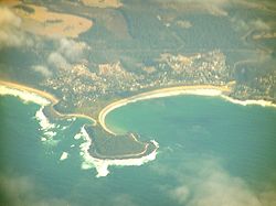
Broulee harbour was lost in 1873 as removal of vegetation for an access road on the land spit eroded the spit and isolated what is now known as Broulee Island. In the last decades of the twentieth century, the spit or tombolo
Tombolo
A tombolo, from the Italian tombolo, derived from the Latin tumulus, meaning 'mound,' and sometimes translated as ayre , is a deposition landform in which an island is attached to the mainland by a narrow piece of land such as a spit or bar. Once attached, the island is then known as a tied island...
has reformed.
From 1972 the island has been managed as the Broulee Island Nature Reserve
Broulee Island Nature Reserve
The Broulee Island Nature Reserve is a 43–hectare reserve on the south coast of New South Wales, Australia. The reserve was created in 1972 and is managed by the New South Wales Department of Environment and Climate Change. The reserve is adjacent to the village of Broulee.- External links :*...
.
There is a lighthouse on Burrewarra Point
Burrewarra Point
Burrewarra Point is to the north of Broulee and 25 kilometers to the south of Batemans Bay on the south coast of New South Wales, Australia.An active lighthouse, Burrewarra Point Light, is located at Burrewarra Point. It was built in 1974....
to the north of Broulee.
Businesses in the town include a general store / post office / liquor outlet / fuel. There is a newsagent, a take-away food outlet and a real estate agency.
The southern beach has a Surf Lifesaving Club with facilities including toilets, accessed from a road below the headland. There is also a boat launching ramp here, but weather conditions need to be right.
There is a modern caravan park with on-site vans and cabins available. Another camping area (basic) is located at the southern end of the South Beach, adjacent to Moruya Airport and Moruya River (boat ramp).
There are other accommodation options including a motel, bed and breakfast establishments, and holiday cottages for rent.
There are a number of schools in the area.
There is no police station or medical facility, the closest being Moruya. The Rural Fire Service has a volunteer station.
Activities in the area include surfing, swimming, wind surfing, fishing (beach, rock, estury, ocean) walks, bicycling. Vehicle touring to nearby scenic beaches and headlands is popular. There are 4WD opportunities in nearby State Forests and National Parks.
Mogo is a nearby village with artists, crafts and food, as well as historic Mogo Goldfields and the Mogo Zoo.
Broulee is a popular weekend destination for residents of Canberra and the Australian Capitol Territory.