
Yuin
Encyclopedia
Yuin people are those Australian Aborigines
from the South Coast of New South wales
who are considered to be the traditional owners of the land and water from Merimbula to Port Jackson
.
, Walbanga, or Wandandian.
The country the Yuin ancestors occupied, used, and enjoyed reached across from Cape Howe
to the Shoalhaven River
and inland to the Great Dividing Range
.
Two of the Yuin groups include:
and Batemans Bay
. The population was reduced to only 600 by the mid nineteenth century due to smallpox
epidemics in 1789
and 1830
, as well as tribal battles and the spread of venereal disease from whaler
s.
The Eurobodalla Shire Council
signed a Local Agreement with the Yuin people in 1998. In 2001, a Memorandum of Understanding was signed between the Bega, Eden and Merrimans Local Aboriginal Land Councils, the Native Title Holders and the Bega Valley Shire Council
.
 The Yuin are considered as the traditional owners of Wallaga Lake land. The former Wallaga Lake National Park is incorporated into Gulaga National Park
.
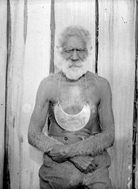
Merriman Island in Wallaga Lake is a sacred place for the Yuin people. On 25 November 1977, it was the first place in New South Wales to be declared an Aboriginal Heritage site by the New South Wales National Parks and Wildlife Service (NPWS). The island was named after King Merriman, leader of the Yuin, who died in 1904. His Aboriginal name was Umbarra. His wife was Queen Narelle.
Mumbulla Mountain, located in the middle of Bega Valley Shire
, was named in November 1973, after Jack Mumbulla, who was a senior man of the Yuin people. Mumbulla Mountain is the central place of significance in Biamanga National Park
. Certain areas have been recognised as a ceremonial meeting places for Aboriginal men and women.
Mount Dromedary, recently renamed Gulaga Mountain, in the Gulaga National Park
, is described by Aboriginal people as the place of ancestral origin for Yuin people. Gulaga itself symbolises the mother and provides a basis for Aboriginal spiritual identity, for Aboriginal women and men.
On 6 May 2006 the freehold titles to Gulaga and Biamanga National Parks were handed back to the Yuin people by the New South Wales Government. Freehold title of Gulaga National Park will be held in trust for the aboriginal owners by Merrimans and Wagonga Local Aboriginal Lands Councils, while that of Biamanga will be held in trust by Merrimans and Bega Local Aboriginal Lands Councils.
Montague Island
is known to the Yuin people as Barranguba. Barranguba is regarded as being the son of Gulaga, along with Najanuga; Barranguba being the oldest son and allowed out to sea, whereas Najanuga had to stay close to his mother.
Australian Aborigines
Australian Aborigines , also called Aboriginal Australians, from the latin ab originem , are people who are indigenous to most of the Australian continentthat is, to mainland Australia and the island of Tasmania...
from the South Coast of New South wales
New South Wales
New South Wales is a state of :Australia, located in the east of the country. It is bordered by Queensland, Victoria and South Australia to the north, south and west respectively. To the east, the state is bordered by the Tasman Sea, which forms part of the Pacific Ocean. New South Wales...
who are considered to be the traditional owners of the land and water from Merimbula to Port Jackson
Port Jackson
Port Jackson, containing Sydney Harbour, is the natural harbour of Sydney, Australia. It is known for its beauty, and in particular, as the location of the Sydney Opera House and Sydney Harbour Bridge...
.
Country
All Yuin people share in common, ancestors who spoke as their first preferred language, one or more of the Yuin language dialects, including Djiringanj, ThauaThaua people
Thaua people, or Thauaira or Thawa or Tharawal people of the Yuin nation of the South Coast of New South Wales.The associated language name is Thurga /Thoorga / Durga/ Dhurga.-Country:...
, Walbanga, or Wandandian.
The country the Yuin ancestors occupied, used, and enjoyed reached across from Cape Howe
Cape Howe
Cape Howe is a coastal headland in Australia, forming the south-eastern end of the Black-Allen Line, the border between New South Wales and Victoria.-History:...
to the Shoalhaven River
Shoalhaven River
The Shoalhaven River is a river rising from the Southern Tablelands and flowing into the ocean near Nowra on the South Coast of New South Wales, Australia.- History :...
and inland to the Great Dividing Range
Great Dividing Range
The Great Dividing Range, or the Eastern Highlands, is Australia's most substantial mountain range and the third longest in the world. The range stretches more than 3,500 km from Dauan Island off the northeastern tip of Queensland, running the entire length of the eastern coastline through...
.
Two of the Yuin groups include:
- Walbanga, north of present day, NaroomaNarooma, New South WalesNarooma is a town in the Australian state of New South Wales on the far south coast. The town is on the Princes Highway. The name is said to be derived from the Aboriginal word meaning ‘clear blue waters’. At the 2006 census, Narooma had a population of 3,100 people.Montague Island, a National...
- Dyiringanj, or Djiringanj, from Narooma, south to BegaBega, New South WalesBega is a town in the south-east of New South Wales, Australia in the Bega Valley Shire. It is the economic centre for the Bega Valley.-Place name:One claim is that place name Bega is derived from the local Aboriginal word meaning "big camping ground"....
and west to the top of the range.
History
The population before 1788 has been estimated at about 11 000 between Cape HoweCape Howe
Cape Howe is a coastal headland in Australia, forming the south-eastern end of the Black-Allen Line, the border between New South Wales and Victoria.-History:...
and Batemans Bay
Batemans Bay, New South Wales
- Media :Radio Stations*East Coast Radio 2EC *Power FM NSW South Coast - POWER FM from Nowra can also be received in parts of Batemans Bay on FM 94.9....
. The population was reduced to only 600 by the mid nineteenth century due to smallpox
Smallpox
Smallpox was an infectious disease unique to humans, caused by either of two virus variants, Variola major and Variola minor. The disease is also known by the Latin names Variola or Variola vera, which is a derivative of the Latin varius, meaning "spotted", or varus, meaning "pimple"...
epidemics in 1789
1789 in Australia
See also:1788 in Australiaother events of 1789,1790 in Australia and theTimeline of Australian history.-Leaders:*Governor of New South Wales – Captain Arthur Phillip*Governor of Norfolk Island – Philip Gidley King...
and 1830
1830 in Australia
See also:1829 in Australia,other events of 1830,1831 in Australia and theTimeline of Australian history.-Governors:Governors of the Australian colonies:*Governor of New South Wales - Ralph Darling*Lieutenant-Governor of Tasmania - Colonel George Arthur...
, as well as tribal battles and the spread of venereal disease from whaler
Whaling
Whaling is the hunting of whales mainly for meat and oil. Its earliest forms date to at least 3000 BC. Various coastal communities have long histories of sustenance whaling and harvesting beached whales...
s.
The Eurobodalla Shire Council
Eurobodalla Shire
Eurobodalla Shire is a Local Government Area in the state of New South Wales, Australia. It is located in a largely mountainous coastal region on the South Coast of New South Wales. It is on the Pacific Ocean, the Princes Highway and the Kings Highway....
signed a Local Agreement with the Yuin people in 1998. In 2001, a Memorandum of Understanding was signed between the Bega, Eden and Merrimans Local Aboriginal Land Councils, the Native Title Holders and the Bega Valley Shire Council
Bega Valley
Bega Valley Shire is located on the south-eastern coastline of New South Wales and extends from Bermagui in the north to the Victorian border in the south. It includes the towns of Bega, Tathra, Merimbula, Tura Beach, Wolumla, Cobargo, Bemboka, Pambula, Pambula Beach, Towamba and the former whaling...
.
Places
Gulaga National Park
Gulaga is a national park on the south coast of New South Wales, Australia. The park was created in 2001. It is 46.73 km² in area.On 6 May 2006 the freehold titles to Gulaga and Biamanga National Parks were handed back to the Yuin people by the New South Wales Government...
.
Merriman Island in Wallaga Lake is a sacred place for the Yuin people. On 25 November 1977, it was the first place in New South Wales to be declared an Aboriginal Heritage site by the New South Wales National Parks and Wildlife Service (NPWS). The island was named after King Merriman, leader of the Yuin, who died in 1904. His Aboriginal name was Umbarra. His wife was Queen Narelle.
Mumbulla Mountain, located in the middle of Bega Valley Shire
Bega Valley
Bega Valley Shire is located on the south-eastern coastline of New South Wales and extends from Bermagui in the north to the Victorian border in the south. It includes the towns of Bega, Tathra, Merimbula, Tura Beach, Wolumla, Cobargo, Bemboka, Pambula, Pambula Beach, Towamba and the former whaling...
, was named in November 1973, after Jack Mumbulla, who was a senior man of the Yuin people. Mumbulla Mountain is the central place of significance in Biamanga National Park
Biamanga National Park
Biamanga National Park is a national park in New South Wales, Australia, 307 km south of Sydney....
. Certain areas have been recognised as a ceremonial meeting places for Aboriginal men and women.
Mount Dromedary, recently renamed Gulaga Mountain, in the Gulaga National Park
Gulaga National Park
Gulaga is a national park on the south coast of New South Wales, Australia. The park was created in 2001. It is 46.73 km² in area.On 6 May 2006 the freehold titles to Gulaga and Biamanga National Parks were handed back to the Yuin people by the New South Wales Government...
, is described by Aboriginal people as the place of ancestral origin for Yuin people. Gulaga itself symbolises the mother and provides a basis for Aboriginal spiritual identity, for Aboriginal women and men.
On 6 May 2006 the freehold titles to Gulaga and Biamanga National Parks were handed back to the Yuin people by the New South Wales Government. Freehold title of Gulaga National Park will be held in trust for the aboriginal owners by Merrimans and Wagonga Local Aboriginal Lands Councils, while that of Biamanga will be held in trust by Merrimans and Bega Local Aboriginal Lands Councils.
Montague Island
Montague Island
Montague Island is 9 kilometres offshore from Narooma on the south coast of New South Wales, Australia.-Lighthouse:On the island is a lighthouse maintained by the Australian Maritime Safety Authority. The lighthouse was designed by James Barnet and built in 1881. It was automated in 1986 and...
is known to the Yuin people as Barranguba. Barranguba is regarded as being the son of Gulaga, along with Najanuga; Barranguba being the oldest son and allowed out to sea, whereas Najanuga had to stay close to his mother.
Alternative names
The Yuin are also known as: Yuwin, Djiringanj, Dyirringan, Jeringin or Juwin.External links
- AusAnthrop Australian Aboriginal tribal database entry for Thaua (aka Thurga, aka Yuin) Accessed 9 June 2008
- Tindale, Norman (1974) "Djiringanj" (dialect of Yuin) in his Catalogue of Australian Aboriginal Tribes. South Australian Museum. Accessed 9 2008
- Portion of Norman Tindale's (1974) Tribal Boundary Map including Djiringanj, Thaua, Walbanga, & Wandandian Accessed from South Australian Museum website 9 June 2008