

English Riviera Geopark
Encyclopedia
Torbay
Torbay is an east-facing bay and natural harbour, at the western most end of Lyme Bay in the south-west of England, situated roughly midway between the cities of Exeter and Plymouth. Part of the ceremonial county of Devon, Torbay was made a unitary authority on 1 April 1998...
is one of ten Geopark
Geopark
A Geopark is defined by the United Nations Educational, Scientific and Cultural Organization in its UNESCO Geoparks International Network of Geoparks programme as follows:...
s in the United Kingdom
United Kingdom
The United Kingdom of Great Britain and Northern IrelandIn the United Kingdom and Dependencies, other languages have been officially recognised as legitimate autochthonous languages under the European Charter for Regional or Minority Languages...
, and one of fifty-three worldwide. It is the only urban
Urban area
An urban area is characterized by higher population density and vast human features in comparison to areas surrounding it. Urban areas may be cities, towns or conurbations, but the term is not commonly extended to rural settlements such as villages and hamlets.Urban areas are created and further...
Geopark, and was declared a Geopark on 16 September 2007. The Geopark covers 6,200 hectare
Hectare
The hectare is a metric unit of area defined as 10,000 square metres , and primarily used in the measurement of land. In 1795, when the metric system was introduced, the are was defined as being 100 square metres and the hectare was thus 100 ares or 1/100 km2...
s of land and 4,100 hectares of sea bed.
Geopark status was granted to Torbay on the grounds that the area has a varied geology
Geology
Geology is the science comprising the study of solid Earth, the rocks of which it is composed, and the processes by which it evolves. Geology gives insight into the history of the Earth, as it provides the primary evidence for plate tectonics, the evolutionary history of life, and past climates...
covering several geological periods, which are exposed to the surface in many areas, and also that Torbay Council and other bodies have worked to promote the area's distinctive geology to the community via education.
Selected sites

Babbacombe
"Babbacombe" may also refer to John 'Babbacombe' LeeBabbacombe is a district of Torquay, Devon, England. It is notable for Babbacombe Model Village, and its clifftop green, Babbacombe Downs, from which Oddicombe Beach is accessed via Babbacombe Cliff Railway.There is a miniature village in the area....
cliffs has upside down layering of slate
Slate
Slate is a fine-grained, foliated, homogeneous metamorphic rock derived from an original shale-type sedimentary rock composed of clay or volcanic ash through low-grade regional metamorphism. The result is a foliated rock in which the foliation may not correspond to the original sedimentary layering...
s and limestone
Limestone
Limestone is a sedimentary rock composed largely of the minerals calcite and aragonite, which are different crystal forms of calcium carbonate . Many limestones are composed from skeletal fragments of marine organisms such as coral or foraminifera....
formed during the Variscan orogeny
Variscan orogeny
The Variscan orogeny is a geologic mountain-building event caused by Late Paleozoic continental collision between Euramerica and Gondwana to form the supercontinent of Pangaea.-Naming:...
. Permian
Permian
The PermianThe term "Permian" was introduced into geology in 1841 by Sir Sir R. I. Murchison, president of the Geological Society of London, who identified typical strata in extensive Russian explorations undertaken with Edouard de Verneuil; Murchison asserted in 1841 that he named his "Permian...
red breccia
Breccia
Breccia is a rock composed of broken fragments of minerals or rock cemented together by a fine-grained matrix, that can be either similar to or different from the composition of the fragments....
is also visible there. Berry Head
Berry Head
Berry Head is a coastal headland at the southern end of Torbay, to the southeast of Brixham, Devon, England.-National Nature Reserve:Berry Head to Sharkham Point is a haven for several nationally rare and threatened species which are dependent upon the thin limestone soils, mild climate and exposed...
to Sharkham Point
Sharkham Point
thumb|Sharkham Point.Sharkham Point is a headland located close to the Devon fishing town of Brixham. It overlooks St. Mary's Bay and is a short walk away from Berry Head Country Park. This stretch was originally the Coastguard Walk along which the coastguards regularly patrolled. At St...
has exposed marine cave systems. Black Head to Anstey's Cove has Torbay's largest outcrop of igneous rock
Igneous rock
Igneous rock is one of the three main rock types, the others being sedimentary and metamorphic rock. Igneous rock is formed through the cooling and solidification of magma or lava...
. Crystal Cove has a 25 metre wide zone of calcite
Calcite
Calcite is a carbonate mineral and the most stable polymorph of calcium carbonate . The other polymorphs are the minerals aragonite and vaterite. Aragonite will change to calcite at 380-470°C, and vaterite is even less stable.-Properties:...
. Kents Cavern and Brixham Cavern contained fossils of the Woolly Rhinoceros
Woolly Rhinoceros
The woolly rhinoceros is an extinct species of rhinoceros that was common throughout Europe and Asia during the Pleistocene epoch and survived the last glacial period. The genus name Coelodonta means "cavity tooth"...
and Cave Lion
Cave lion
Panthera leo spelaea also known as the European or Eurasian cave lion, is an extinct subspecies of lion known from fossils and many examples of prehistoric art.-Physical characteristics:This subspecies was one of the largest lions...
. Dyers Quarry is rich in coral
Coral
Corals are marine animals in class Anthozoa of phylum Cnidaria typically living in compact colonies of many identical individual "polyps". The group includes the important reef builders that inhabit tropical oceans and secrete calcium carbonate to form a hard skeleton.A coral "head" is a colony of...
fossilised in its growing position, as well as Late Eifelian limestone. Hollicombe Head to Corbyn Head have features of alluvial fan
Alluvial fan
An alluvial fan is a fan-shaped deposit formed where a fast flowing stream flattens, slows, and spreads typically at the exit of a canyon onto a flatter plain. A convergence of neighboring alluvial fans into a single apron of deposits against a slope is called a bajada, or compound alluvial...
conglomerate
Conglomerate (geology)
A conglomerate is a rock consisting of individual clasts within a finer-grained matrix that have become cemented together. Conglomerates are sedimentary rocks consisting of rounded fragments and are thus differentiated from breccias, which consist of angular clasts...
deposits and seasonal river sandstone
Sandstone
Sandstone is a sedimentary rock composed mainly of sand-sized minerals or rock grains.Most sandstone is composed of quartz and/or feldspar because these are the most common minerals in the Earth's crust. Like sand, sandstone may be any colour, but the most common colours are tan, brown, yellow,...
s, both Permian
Permian
The PermianThe term "Permian" was introduced into geology in 1841 by Sir Sir R. I. Murchison, president of the Geological Society of London, who identified typical strata in extensive Russian explorations undertaken with Edouard de Verneuil; Murchison asserted in 1841 that he named his "Permian...
in origin. Hopes Nose features gold
Gold
Gold is a chemical element with the symbol Au and an atomic number of 79. Gold is a dense, soft, shiny, malleable and ductile metal. Pure gold has a bright yellow color and luster traditionally considered attractive, which it maintains without oxidizing in air or water. Chemically, gold is a...
and palladium
Palladium
Palladium is a chemical element with the chemical symbol Pd and an atomic number of 46. It is a rare and lustrous silvery-white metal discovered in 1803 by William Hyde Wollaston. He named it after the asteroid Pallas, which was itself named after the epithet of the Greek goddess Athena, acquired...
mineral deposits left by hydrothermal fluids, and the area is also important for the study of Quaternary
Quaternary
The Quaternary Period is the most recent of the three periods of the Cenozoic Era in the geologic time scale of the ICS. It follows the Neogene Period, spanning 2.588 ± 0.005 million years ago to the present...
stratigraphy
Stratigraphy
Stratigraphy, a branch of geology, studies rock layers and layering . It is primarily used in the study of sedimentary and layered volcanic rocks....
and sea level change. Long Quarry features evidence of the development, formation and growth of a stromatoporoid reef
Reef
In nautical terminology, a reef is a rock, sandbar, or other feature lying beneath the surface of the water ....
. Lummaton Quarry's shell deposits led to the naming of the Devonian
Devonian
The Devonian is a geologic period and system of the Paleozoic Era spanning from the end of the Silurian Period, about 416.0 ± 2.8 Mya , to the beginning of the Carboniferous Period, about 359.2 ± 2.5 Mya...
period. Saltern Cove
Saltern Cove
Saltern Cove is a Site of Special Scientific Interest. It is in Paignton, Devon on the South coast of England.-Flora and fauna:The rocky coastline at Saltern Cove supports diverse communities of intertidal plants and animals...
is a regionally important unconformity
Unconformity
An unconformity is a buried erosion surface separating two rock masses or strata of different ages, indicating that sediment deposition was not continuous. In general, the older layer was exposed to erosion for an interval of time before deposition of the younger, but the term is used to describe...
and Site of Special Scientific Interest
Site of Special Scientific Interest
A Site of Special Scientific Interest is a conservation designation denoting a protected area in the United Kingdom. SSSIs are the basic building block of site-based nature conservation legislation and most other legal nature/geological conservation designations in Great Britain are based upon...
.
Devonian
The earliest rocks within the Geopark were deposited in environments not unlike the Caribbean today, warm, life rich shallow seas provided the geopark with the Torbay Limestones and sandstones. At the same time volcanic eruptions blanketed the sediments with volcanic ash.The limestone was held together by hard sponges known as stromatoporoids - modern corals that we are accustomed to day were yet to evolve; but early corals did thrive alongside crinoids and trilobites alongside early relatives of ammonites. At this time the landmass was below the equator.
Carboniferous
During the Carboniferous the limestones and sandstones of the Devonian were forced up within the Variscan OrogenyVariscan orogeny
The Variscan orogeny is a geologic mountain-building event caused by Late Paleozoic continental collision between Euramerica and Gondwana to form the supercontinent of Pangaea.-Naming:...
which stretched across Devon and Cornwall (forming the granites of Dartmoor
Dartmoor
Dartmoor is an area of moorland in south Devon, England. Protected by National Park status, it covers .The granite upland dates from the Carboniferous period of geological history. The moorland is capped with many exposed granite hilltops known as tors, providing habitats for Dartmoor wildlife. The...
) as far afield as the Czech Republic in the West and North America in the East (although at his point the Atlantic did not exist). This mountain building event had a massive effect on the future geopark, tilting sediments and forming the beautiful fold on the island of Ore Stone.
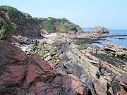
Permian
280 million years ago continental collision had brought the geopark into the centre of Pangea and into the middle of a huge desert, at a similar latitude to the Sahara. This desert is preserved as both wind blown, fine sandstones which form Roundham Head, and brecciaBreccia
Breccia is a rock composed of broken fragments of minerals or rock cemented together by a fine-grained matrix, that can be either similar to or different from the composition of the fragments....
which was deposited after large storms and flash floods that periodically occurred within the usually parched desert, these rocks stretch across the UK and is found as far afield as Yorkshire. Collectively they are known as the New Red Sandstone
New Red Sandstone
The New Red Sandstone is a chiefly British geological term for the beds of red sandstone and associated rocks laid down throughout the Permian to the beginning of the Triassic that underlie the Jurassic Lias; the term distinguishes it from the Old Red Sandstone which is largely Devonian in...
. Their red colour (and thus the colour of the soil overlaying them) is derived from groundwater under the desert caused iron in the sediments to alter to haematite.
Mesozoic and Tertiary
During the TriassicTriassic
The Triassic is a geologic period and system that extends from about 250 to 200 Mya . As the first period of the Mesozoic Era, the Triassic follows the Permian and is followed by the Jurassic. Both the start and end of the Triassic are marked by major extinction events...
, Jurassic
Jurassic
The Jurassic is a geologic period and system that extends from about Mya to Mya, that is, from the end of the Triassic to the beginning of the Cretaceous. The Jurassic constitutes the middle period of the Mesozoic era, also known as the age of reptiles. The start of the period is marked by...
, Cretaceous
Cretaceous
The Cretaceous , derived from the Latin "creta" , usually abbreviated K for its German translation Kreide , is a geologic period and system from circa to million years ago. In the geologic timescale, the Cretaceous follows the Jurassic period and is followed by the Paleogene period of the...
and Tertiary
Tertiary
The Tertiary is a deprecated term for a geologic period 65 million to 2.6 million years ago. The Tertiary covered the time span between the superseded Secondary period and the Quaternary...
sediments continued to be deposited over the Geopark; but later erosion has removed them, leaving no trace; however activity elsewhere across the globe has left impressions on the geopark; the collision of Africa and Europe
Geology of the Alps
The Alps form part of a Tertiary orogenic belt of mountain chains, called the Alpide belt, that stretches through southern Europe and Asia from the Atlantic all the way to the Himalayas. This belt of mountain chains was formed during the Alpine orogeny. A gap in these mountain chains in central...
has been felt in the geoaprk, leaving the bay criss-crossed with faults as a result of the huge pressures.