
Deschutes River
Encyclopedia
The Deschutes River in central Oregon
is a major tributary of the Columbia River
. The river provides much of the drainage on the eastern side of the Cascade Range
in Oregon, gathering many of the tributaries that descend from the eastern, drier flank of the mountains. It provided a major route to and from the Columbia for Native Americans
and later pioneers on the Oregon Trail
. It flows mostly through rugged and arid country, and its valley provides a cultural heart for central Oregon. Today the river provides irrigation
and is popular in the summer for whitewater
rafting
and fishing
.
, a lake
in the Cascade Mountains located approximately 26 miles (42 km) northwest of the city of LaPine. The river flows south into Crane Prairie Reservoir
then into a second reservoir (the Wickiup Reservoir
, from there it heads in a northeasterly direction past the resort community of Sunriver
into the city of Bend
). In Bend, much of the river's waters is diverted for irrigation
; as a result, the river is much smaller when it leaves the city.
The river continues north from Bend, past the city of Redmond
. As it heads north through the central Oregon desert; the river carves a gorge. By the time it reaches Lake Billy Chinook west of Madras
, the river is approximately 300 feet (91 m) below the surrounding plateau, Little Agency Plains and Agency Plains
. At Lake Billy Chinook (a lake formed by Round Butte Dam
), the river is joined by the Crooked
and Metolius
rivers.
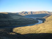
Beyond the dam, the river continues to flow north in a gorge well below the surrounding countryside. It passes through the Warm Springs Indian Reservation
, including the city of Warm Springs
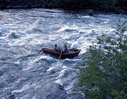
and the Kah-Nee-Ta resort. There are two main sections of the river that are popular for whitewater
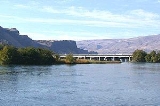
rafting. The upstream section is a short segment upriver from the city of Bend. The lower and more heavily used section is from the town of Warm Springs downstream to just above Sherars Falls. The river ends at its confluence with the Columbia
, 5 miles (8 km) southwest of Biggs Junction
.
, had diverted the river westward to its present day location.
 The river was named
Riviere des Chutes or Riviere aux Chutes, French
for River of the Falls, during the period of fur trading. The waterfall
it referred to was the Celilo Falls
on the Columbia River
, near where the Deschutes flowed into it. (These falls no longer exist, having been inundated by the lake behind The Dalles Dam).
Lewis and Clark
encountered the river on October 22, 1805, and referred to it by the Native American name Towarnehiooks; on their return journey they gave it the new name Clarks River. Variant names include Clarks River, River of the Falls, Riviere des Chutes, Chutes River, and Falls River.
During the middle 19th century, the river was a major obstacle for immigrants on the Oregon Trail. The major crossing point on the river was near its mouth in present-day Deschutes River State Recreation Area
. Many immigrants camped on the bluff on the west side of the river after making the crossing. The remains of the trail leading up to the top of the bluff are still visible.
 The river is world renowned for its fly fishing
. It is home to a unique wild and native strain of Rainbow trout
known locally as "redsides" or redband trout
. The redsides grow larger than most and also have a distinct darker red stripe than most wild rainbow trout. They are abundant in this stretch of the river, which has counts of 1,700 fish of 7 inches in size per mile (1,100 fish of 18 centimeters in size per kilometer) above Sherars Falls, and they are noticeably stronger than trout who do not have to cope with life in such a big, powerful river. The average catch for these fish is 8 inches (20 cm) to 15 inches (38 cm), and some are much larger. These redside or redband trout are found throughout the river. Fishing for them is most popular from Warm Springs down to Macks Canyon. (Warm Springs Reservation owns the entire Deschutes West Bank from 16 miles (26 km) south of Maupin
to Lake Billy Chinook and on up to Jefferson Creek on the Metolius River
arm) below Pelton Dam. Fishing from Tribal lands requires special permits. From Pelton Dam to the mouth the Deschutes is one of America's most productive trout waters and a top producer of summer steelhead, managed primarily for wild trout. This 100-mile (160 km) stretch of river drops 1233 feet (376 m), carving a volcanic rock canyon 700 feet (213 m) to 2200 feet (671 m) deep.
Fly fishermen come from around the world in the last two weeks in May through the first two weeks in June to take advantage of the Stoneflies (both salmonflies and golden stones) hatch. These bugs are in the river year-round; however their large adults are a major food source for the fish. Weighted stonefly nymph patterns are a staple for Deschutes anglers and produce year round.
Sport fishing for Steelhead occurs in the river from the mouth to Round Butte Dam
. Sport fishing for spring and fall chinook salmon occurs from the mouth to Sherars Falls. Tribal fishing for chinook and steelhead occurs at Sherars Falls.
In Lake Billy Chinook (reservoir), there are fisheries for kokanee, bull trout
, rainbow trout
, brown trout
, and several warm water species such as large mouth bass and a very large population of small mouth bass. There are also periodic commercial fisheries for crayfish
. The bull trout that are caught in this reservoir are some of the largest bull trout caught on the west coast. The numbers are scarce because the bull's are endangered; however, numbers have risen every year since they became protected. The lake allows an individual to keep a bull trout that measures more than 24 inches (61 cm). (This is included for a daily bag limit.)
 Much of the flow of the upper Deschutes River is diverted into canal
s to irrigate farmland; Irrigation Districts take as much as 97% of the river's flow in the summer months. The growth of cities like Bend
and Redmond
also increased demand on the river's water, which is over allocated. Because the existing canals lose about 65% of their water due to leaks and evaporation, there is pressure to convert these canals into pipelines, a move that is resisted by many locals for historic or scenic reasons. Golf courses have also been an issue with water allocation. There are thirteen golf courses throughout Bend, Redmond, and Sunriver.
The lower river is used primarily for recreation.
The river flows north, which is unusual in the United States. Several other Oregon tributaries of the Columbia River
, including the Willamette
and John Day
Rivers, also flow in a northerly direction.
Oregon
Oregon is a state in the Pacific Northwest region of the United States. It is located on the Pacific coast, with Washington to the north, California to the south, Nevada on the southeast and Idaho to the east. The Columbia and Snake rivers delineate much of Oregon's northern and eastern...
is a major tributary of the Columbia River
Columbia River
The Columbia River is the largest river in the Pacific Northwest region of North America. The river rises in the Rocky Mountains of British Columbia, Canada, flows northwest and then south into the U.S. state of Washington, then turns west to form most of the border between Washington and the state...
. The river provides much of the drainage on the eastern side of the Cascade Range
Cascade Range
The Cascade Range is a major mountain range of western North America, extending from southern British Columbia through Washington and Oregon to Northern California. It includes both non-volcanic mountains, such as the North Cascades, and the notable volcanoes known as the High Cascades...
in Oregon, gathering many of the tributaries that descend from the eastern, drier flank of the mountains. It provided a major route to and from the Columbia for Native Americans
Native Americans in the United States
Native Americans in the United States are the indigenous peoples in North America within the boundaries of the present-day continental United States, parts of Alaska, and the island state of Hawaii. They are composed of numerous, distinct tribes, states, and ethnic groups, many of which survive as...
and later pioneers on the Oregon Trail
Oregon Trail
The Oregon Trail is a historic east-west wagon route that connected the Missouri River to valleys in Oregon and locations in between.After 1840 steam-powered riverboats and steamboats traversing up and down the Ohio, Mississippi and Missouri rivers sped settlement and development in the flat...
. It flows mostly through rugged and arid country, and its valley provides a cultural heart for central Oregon. Today the river provides irrigation
Irrigation
Irrigation may be defined as the science of artificial application of water to the land or soil. It is used to assist in the growing of agricultural crops, maintenance of landscapes, and revegetation of disturbed soils in dry areas and during periods of inadequate rainfall...
and is popular in the summer for whitewater
Whitewater
Whitewater is formed in a rapid, when a river's gradient increases enough to disturb its laminar flow and create turbulence, i.e. form a bubbly, or aerated and unstable current; the frothy water appears white...
rafting
Rafting
Rafting or white water rafting is a challenging recreational outdoor activity using an inflatable raft to navigate a river or other bodies of water. This is usually done on white water or different degrees of rough water, in order to thrill and excite the raft passengers. The development of this...
and fishing
Fishing
Fishing is the activity of trying to catch wild fish. Fish are normally caught in the wild. Techniques for catching fish include hand gathering, spearing, netting, angling and trapping....
.
Description
The headwaters of the Deschutes River is Little Lava LakeLittle Lava Lake
Little Lava Lake is located about southwest of Bend, Oregon, United States. The lake is approximately in size and has a maximum depth of about . The lake lies at the elevation of . The lake lies about a half mile south of Big Lava Lake. The lake has a small forest service campground and a...
, a lake
Lake
A lake is a body of relatively still fresh or salt water of considerable size, localized in a basin, that is surrounded by land. Lakes are inland and not part of the ocean and therefore are distinct from lagoons, and are larger and deeper than ponds. Lakes can be contrasted with rivers or streams,...
in the Cascade Mountains located approximately 26 miles (42 km) northwest of the city of LaPine. The river flows south into Crane Prairie Reservoir
Crane Prairie Reservoir
Crane Prairie Reservoir is a man-made reservoir located about southwest of Bend, in Deschutes County, Oregon, United States, that also serves as one of Oregon's largest rainbow trout fisheries. It was so named because cranes often fish there. The dam was constructed in 1922 to prevent flooding to...
then into a second reservoir (the Wickiup Reservoir
Wickiup Reservoir
Wickiup Reservoir is the second-largest reservoir in the U.S. state of Oregon. It is located southwest of Bend, and is the largest of the Cascade Lakes. Wickiup Reservoir is close to Twin Lakes, Davis Lake, Crane Prairie Reservoir, Cultus Lake, and Little Cultus Lake...
, from there it heads in a northeasterly direction past the resort community of Sunriver
Sunriver, Oregon
Sunriver, Oregon is a private planned resort community in Deschutes County, Oregon, United States. It is part of the Bend, Oregon Metropolitan Statistical Area...
into the city of Bend
Bend, Oregon
Bend is a city in and the county seat of Deschutes County, Oregon, United States, and the principal city of the Bend, Oregon Metropolitan Statistical Area. Bend is Central Oregon's largest city, and, despite its modest size, is the de facto metropolis of the region, owing to the low population...
). In Bend, much of the river's waters is diverted for irrigation
Irrigation
Irrigation may be defined as the science of artificial application of water to the land or soil. It is used to assist in the growing of agricultural crops, maintenance of landscapes, and revegetation of disturbed soils in dry areas and during periods of inadequate rainfall...
; as a result, the river is much smaller when it leaves the city.
The river continues north from Bend, past the city of Redmond
Redmond, Oregon
Redmond is a city in Deschutes County, Oregon, United States. Incorporated on July 6, 1910, the city is located on the eastern side of Oregon's Cascade Range, in the High Desert, and is considered the geographical heart of Central Oregon...
. As it heads north through the central Oregon desert; the river carves a gorge. By the time it reaches Lake Billy Chinook west of Madras
Madras, Oregon
Madras is a city in Jefferson County, Oregon, United States. Originally called The Basin after the circular valley the city is located in, it is unclear as to whether Madras was named in 1903 for the cotton fabric called "Madras" that originated in the Madras area in India, or from the city of...
, the river is approximately 300 feet (91 m) below the surrounding plateau, Little Agency Plains and Agency Plains
Agency Plains (Oregon)
Agency Plains is a plateau just north of the city of Madras, Oregon, United States. It extends approximately north to south and east to west some in elevation above the east side of the Deschutes River. The area is composed of arable land and was the homestead area of the Guard, Campbell, and...
. At Lake Billy Chinook (a lake formed by Round Butte Dam
Round Butte Dam
Round Butte Dam is a rockfill-type hydroelectric dam on the Deschutes River, in the U.S. state of Oregon. It is located in Jefferson County. Its reservoir is called Lake Billy Chinook.-References:...
), the river is joined by the Crooked
Crooked River (Oregon)
The Crooked River is a tributary, long, of the Deschutes River in the U.S. state of Oregon. The river begins at the confluence of South Fork Crooked River and Beaver Creek. Of the two tributaries, the South Fork Crooked River is the larger and is sometimes considered part of the Crooked River proper...
and Metolius
Metolius River
The Metolius River is a tributary of the Deschutes River in Central Oregon, United States, near the city of Sisters. The river flows north from springs near Black Butte, then turns sharply east, descending through a series of gorges before ending in the western end of the lake...
rivers.
Beyond the dam, the river continues to flow north in a gorge well below the surrounding countryside. It passes through the Warm Springs Indian Reservation
Warm Springs Indian Reservation
The Warm Springs Indian Reservation consists of 1,019.385 sq mi in north central Oregon, in the United States, and is occupied and governed by the Confederated Tribes of Warm Springs.-Tribes:...
, including the city of Warm Springs
Warm Springs, Oregon
Warm Springs is a census-designated place and an unincorporated community in Jefferson County, Oregon, United States. Located on the Warm Springs Indian Reservation, the community is also known as the "Warm Springs Agency." The population was 2,431 at the 2000 census.-Geography:Warm Springs is...
and the Kah-Nee-Ta resort. There are two main sections of the river that are popular for whitewater
Whitewater
Whitewater is formed in a rapid, when a river's gradient increases enough to disturb its laminar flow and create turbulence, i.e. form a bubbly, or aerated and unstable current; the frothy water appears white...
rafting. The upstream section is a short segment upriver from the city of Bend. The lower and more heavily used section is from the town of Warm Springs downstream to just above Sherars Falls. The river ends at its confluence with the Columbia
Columbia River
The Columbia River is the largest river in the Pacific Northwest region of North America. The river rises in the Rocky Mountains of British Columbia, Canada, flows northwest and then south into the U.S. state of Washington, then turns west to form most of the border between Washington and the state...
, 5 miles (8 km) southwest of Biggs Junction
Biggs Junction, Oregon
Biggs Junction is an unincorporated community in Sherman County, Oregon, United States. For statistical purposes, the United States Census Bureau has defined Biggs Junction as a census-designated place...
.
History
Prior to 80,000 years ago, the river ran along the east side of Pilot Butte and a lava flow from Lava Top Butte filled in this ancient channel. Previously, the Basalt of the Bend lava flow, associated with the Lava River CaveLava River Cave
The Lava River Cave near Bend, Oregon, is part of the Newberry National Volcanic Monument, which is managed by the United States Forest Service. The cave is an excellent example of a lava tube. At 5,211 feet in length, the northwest section of the cave is the longest continuous lava tube in Oregon...
, had diverted the river westward to its present day location.
Oregon Geographic Names
Oregon Geographic Names is an authoritative compilation of the origin and meaning of place names in the U.S. state of Oregon. , the book is in its seventh edition and is compiled and edited by Lewis L. McArthur, who took over from his father, Lewis A. McArthur, as of the fourth edition...
Riviere des Chutes or Riviere aux Chutes, French
French language
French is a Romance language spoken as a first language in France, the Romandy region in Switzerland, Wallonia and Brussels in Belgium, Monaco, the regions of Quebec and Acadia in Canada, and by various communities elsewhere. Second-language speakers of French are distributed throughout many parts...
for River of the Falls, during the period of fur trading. The waterfall
Waterfall
A waterfall is a place where flowing water rapidly drops in elevation as it flows over a steep region or a cliff.-Formation:Waterfalls are commonly formed when a river is young. At these times the channel is often narrow and deep. When the river courses over resistant bedrock, erosion happens...
it referred to was the Celilo Falls
Celilo Falls
Celilo Falls was a tribal fishing area on the Columbia River, just east of the Cascade Mountains, on what is today the border between the U.S. states of Oregon and Washington...
on the Columbia River
Columbia River
The Columbia River is the largest river in the Pacific Northwest region of North America. The river rises in the Rocky Mountains of British Columbia, Canada, flows northwest and then south into the U.S. state of Washington, then turns west to form most of the border between Washington and the state...
, near where the Deschutes flowed into it. (These falls no longer exist, having been inundated by the lake behind The Dalles Dam).
Lewis and Clark
Lewis and Clark Expedition
The Lewis and Clark Expedition, or ″Corps of Discovery Expedition" was the first transcontinental expedition to the Pacific Coast by the United States. Commissioned by President Thomas Jefferson and led by two Virginia-born veterans of Indian wars in the Ohio Valley, Meriwether Lewis and William...
encountered the river on October 22, 1805, and referred to it by the Native American name Towarnehiooks; on their return journey they gave it the new name Clarks River. Variant names include Clarks River, River of the Falls, Riviere des Chutes, Chutes River, and Falls River.
During the middle 19th century, the river was a major obstacle for immigrants on the Oregon Trail. The major crossing point on the river was near its mouth in present-day Deschutes River State Recreation Area
Deschutes River State Recreation Area
The Deschutes River State Recreation Area is a park at the confluence of the Deschutes and Columbia rivers in the U.S. state of Oregon. It is a few miles east of The Dalles. The park offers opportunities for camping, fishing, hiking, mountain biking, and equestrian trail riding.-History:The...
. Many immigrants camped on the bluff on the west side of the river after making the crossing. The remains of the trail leading up to the top of the bluff are still visible.
Fishing
Fly fishing
Fly fishing is an angling method in which an artificial 'fly' is used to catch fish. The fly is cast using a fly rod, reel, and specialized weighted line. Casting a nearly weightless fly or 'lure' requires casting techniques significantly different from other forms of casting...
. It is home to a unique wild and native strain of Rainbow trout
Rainbow trout
The rainbow trout is a species of salmonid native to tributaries of the Pacific Ocean in Asia and North America. The steelhead is a sea run rainbow trout usually returning to freshwater to spawn after 2 to 3 years at sea. In other words, rainbow trout and steelhead trout are the same species....
known locally as "redsides" or redband trout
Redband trout
Redband trout is a fish name that may be a synonym for the rainbow trout, Oncorhynchus mykiss, but is also used more narrowly for inland subspecies with well-defined geographical distributions in the United States...
. The redsides grow larger than most and also have a distinct darker red stripe than most wild rainbow trout. They are abundant in this stretch of the river, which has counts of 1,700 fish of 7 inches in size per mile (1,100 fish of 18 centimeters in size per kilometer) above Sherars Falls, and they are noticeably stronger than trout who do not have to cope with life in such a big, powerful river. The average catch for these fish is 8 inches (20 cm) to 15 inches (38 cm), and some are much larger. These redside or redband trout are found throughout the river. Fishing for them is most popular from Warm Springs down to Macks Canyon. (Warm Springs Reservation owns the entire Deschutes West Bank from 16 miles (26 km) south of Maupin
Maupin, Oregon
Maupin is a city in Wasco County, Oregon, United States. Located on the Deschutes River, much of the city's economy is related to the river through outdoor activities, such as fishing and rafting...
to Lake Billy Chinook and on up to Jefferson Creek on the Metolius River
Metolius River
The Metolius River is a tributary of the Deschutes River in Central Oregon, United States, near the city of Sisters. The river flows north from springs near Black Butte, then turns sharply east, descending through a series of gorges before ending in the western end of the lake...
arm) below Pelton Dam. Fishing from Tribal lands requires special permits. From Pelton Dam to the mouth the Deschutes is one of America's most productive trout waters and a top producer of summer steelhead, managed primarily for wild trout. This 100-mile (160 km) stretch of river drops 1233 feet (376 m), carving a volcanic rock canyon 700 feet (213 m) to 2200 feet (671 m) deep.
Fly fishermen come from around the world in the last two weeks in May through the first two weeks in June to take advantage of the Stoneflies (both salmonflies and golden stones) hatch. These bugs are in the river year-round; however their large adults are a major food source for the fish. Weighted stonefly nymph patterns are a staple for Deschutes anglers and produce year round.
Sport fishing for Steelhead occurs in the river from the mouth to Round Butte Dam
Round Butte Dam
Round Butte Dam is a rockfill-type hydroelectric dam on the Deschutes River, in the U.S. state of Oregon. It is located in Jefferson County. Its reservoir is called Lake Billy Chinook.-References:...
. Sport fishing for spring and fall chinook salmon occurs from the mouth to Sherars Falls. Tribal fishing for chinook and steelhead occurs at Sherars Falls.
In Lake Billy Chinook (reservoir), there are fisheries for kokanee, bull trout
Bull trout
The bull trout, Salvelinus confluentus, is a char of the family Salmonidae native to northwestern North America. Historically, S. confluentus has been known as the "Dolly Varden" , but was re-classified as a separate species in 1980. Bull trout are listed as a threatened species under the U.S....
, rainbow trout
Rainbow trout
The rainbow trout is a species of salmonid native to tributaries of the Pacific Ocean in Asia and North America. The steelhead is a sea run rainbow trout usually returning to freshwater to spawn after 2 to 3 years at sea. In other words, rainbow trout and steelhead trout are the same species....
, brown trout
Brown trout
The brown trout and the sea trout are fish of the same species....
, and several warm water species such as large mouth bass and a very large population of small mouth bass. There are also periodic commercial fisheries for crayfish
Crayfish
Crayfish, crawfish, or crawdads – members of the superfamilies Astacoidea and Parastacoidea – are freshwater crustaceans resembling small lobsters, to which they are related...
. The bull trout that are caught in this reservoir are some of the largest bull trout caught on the west coast. The numbers are scarce because the bull's are endangered; however, numbers have risen every year since they became protected. The lake allows an individual to keep a bull trout that measures more than 24 inches (61 cm). (This is included for a daily bag limit.)
River use
Canal
Canals are man-made channels for water. There are two types of canal:#Waterways: navigable transportation canals used for carrying ships and boats shipping goods and conveying people, further subdivided into two kinds:...
s to irrigate farmland; Irrigation Districts take as much as 97% of the river's flow in the summer months. The growth of cities like Bend
Bend, Oregon
Bend is a city in and the county seat of Deschutes County, Oregon, United States, and the principal city of the Bend, Oregon Metropolitan Statistical Area. Bend is Central Oregon's largest city, and, despite its modest size, is the de facto metropolis of the region, owing to the low population...
and Redmond
Redmond, Oregon
Redmond is a city in Deschutes County, Oregon, United States. Incorporated on July 6, 1910, the city is located on the eastern side of Oregon's Cascade Range, in the High Desert, and is considered the geographical heart of Central Oregon...
also increased demand on the river's water, which is over allocated. Because the existing canals lose about 65% of their water due to leaks and evaporation, there is pressure to convert these canals into pipelines, a move that is resisted by many locals for historic or scenic reasons. Golf courses have also been an issue with water allocation. There are thirteen golf courses throughout Bend, Redmond, and Sunriver.
The lower river is used primarily for recreation.
The river flows north, which is unusual in the United States. Several other Oregon tributaries of the Columbia River
Columbia River
The Columbia River is the largest river in the Pacific Northwest region of North America. The river rises in the Rocky Mountains of British Columbia, Canada, flows northwest and then south into the U.S. state of Washington, then turns west to form most of the border between Washington and the state...
, including the Willamette
Willamette River
The Willamette River is a major tributary of the Columbia River, accounting for 12 to 15 percent of the Columbia's flow. The Willamette's main stem is long, lying entirely in northwestern Oregon in the United States...
and John Day
John Day River
The John Day River is a tributary of the Columbia River, approximately long, in northeastern Oregon in the United States. Undammed along its entire length, the river is the third longest free-flowing river in the conterminous United States. There is extensive use of its waters for irrigation. Its...
Rivers, also flow in a northerly direction.
See also
- List of Oregon rivers
- List of longest streams of Oregon
- List of National Wild and Scenic Rivers
- Boxcar RapidsBoxcar RapidsThe Boxcar Rapids are Class 3 rapids on the Deschutes River, located south and upriver from Maupin, Oregon, United States.-History:...